You also want an ePaper? Increase the reach of your titles
YUMPU automatically turns print PDFs into web optimized ePapers that Google loves.
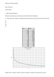
466<br />
465<br />
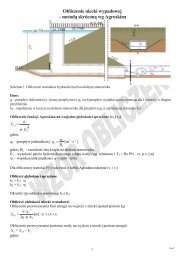
Legend<br />
Q 1%<br />
Q 10%<br />
Q50%<br />
Poziom terenu<br />
Rzędna terenu Elevation [m (m) n.p.m.]<br />
464<br />
463<br />
462<br />
461<br />
460<br />
55<br />
56<br />
57<br />
459<br />
3080 3090 3100 3110 3120 3130 3140 3150 3160 3170<br />
Main Channel Odległość Distance [m] (m)<br />
Profil podłużny dla przepływu Q 1% , Q 10% , Q 50% w przekroju<br />
mostowym nr 56<br />
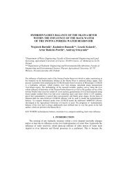
Legend<br />
Rzędna Elevation terenu (m) [m n.p.m.]<br />
498<br />
497<br />
496<br />
Q 1%<br />
Q 10%<br />
Q 50%<br />
Poziom terenu<br />
495<br />
58<br />
59<br />
3980 3990 4000 4010 4020 4030 4040 4050<br />
Odległość [m]<br />
Main Channel Distance (m)<br />
Profil podłużny dla przepływu Q 1% , Q 10% , Q 50% w przekroju<br />
mostowym nr 59