- Page 1 and 2:
~ı~~T.C.KÜLTÜR VE TURİzM BAKANL
- Page 3 and 4:
içiNDEKİLERMehmetTOPHakkari ili v
- Page 5:
Mehmet KARAOSMANOGLU, Mehmet ışı
- Page 8 and 9:
11.30x5.00 m. ölçülerinde, dikd
- Page 10 and 11:
kilde korunmaktadır. Bu yönüyle
- Page 12 and 13:
ii No.lu Mezar Taşı: Toprak üzer
- Page 14 and 15:
vÇizim 1: Kerpil Kilisesi planıÇ
- Page 16 and 17:
Resim 1 : Kerpil Kilisesi, batıcep
- Page 18 and 19:
Resim 6 : Şavita Kilisesi, kuzeyde
- Page 20 and 21:
...III~E.:!ciz..:T""T""E"iiiGlD:cbE
- Page 22 and 23:
Kalkolitik Dônem'Bu döneme ait ma
- Page 24 and 25:
parça, iç kısmındaki (Çizim 5:
- Page 26 and 27:
Urartu Dönemi (Orta Demir çağı)
- Page 28 and 29:
2.2 : Hazinetepe. Krem. Devetüyün
- Page 30 and 31:
10.9: Gre Herşe. Kiremidimsi kahve
- Page 32 and 33:
ÖZFIRAT, A., in press b: ''The Mid
- Page 34 and 35:
iiJ'., 1J"":~.;-; i;.\ ...1," \''''
- Page 36 and 37:
\' ,-,-,--!:{~ F-< ~~i:"l.~'7n'-=-'
- Page 38 and 39:
Resim 3 : Kasım TığıResim 4 : K
- Page 40 and 41:
şik lonoz örtüludü. Güney duva
- Page 42 and 43:
(takriben 1 km.) bir sahayt ihtiva
- Page 44 and 45:
10,01.2002A.Bıı:ır.....zErdll101
- Page 46 and 47:
Resim 10 : Erzen Şehri içkalesiRe
- Page 48 and 49:
in der Frage nach den architektonis
- Page 50 and 51:
gehauene Vertiefung befindet, bei d
- Page 52 and 53:
Abb 1 : Grab des Siderija in Limyra
- Page 54 and 55:
'If .;'"11...Abb 7: Grab des Nturig
- Page 56 and 57: Abb 13 : Grab des iprisida inKyanea
- Page 58 and 59: 1.3..Öksüz Minare: Besni iıçesi
- Page 60 and 61: ~.J...s)J.:,y\y...~.Jiı:JA~~.J ...
- Page 62 and 63: u..,. 4 ~.;b YI> .,;\.1y::. .ı:ı
- Page 64 and 65: ~~~=:=21l1ç;zen:c SALMAN l2003)=.=
- Page 66 and 67: , izim 8: Eski Besni, Bekir Bey Ham
- Page 68 and 69: Resim 4: Eski Besni, Ali Paşa Maha
- Page 70 and 71: decrit dans le rapport 2001. Ason e
- Page 72 and 73: que beaucoup plus tardive que le re
- Page 74 and 75: disparu). Ces sieqes d'honneur repo
- Page 76 and 77: au centre de l'hernicycle a ete evi
- Page 78 and 79: Photo 1: Theatre, vue generalePhoto
- Page 80 and 81: zıtlar ya tamamen silinmiştir ya
- Page 82 and 83: "Adil Tanrılar" (Theoi Dikaioi) ta
- Page 84 and 85: anatolischen Siedlungen Gültigkeit
- Page 86 and 87: (Abb.11), den Verlauf der Leitung z
- Page 88 and 89: Abb 4: Nordtor: Aufsicht; die Felds
- Page 90 and 91: Abb 10: Einziger erhaltener Bogen d
- Page 92 and 93: zü Köyü'nün Taşoluk Mahallesi'
- Page 94 and 95: Üçüncü Aşama27 Ağustos - 2 Ey
- Page 96 and 97: D E NZSAMSUN2ükmil----------"==---
- Page 98 and 99: 1'..uIıUIlIJ(tıı-ı~,ııs.Y;lk1
- Page 100 and 101: Resim: 6Resim: 7Resim: 896
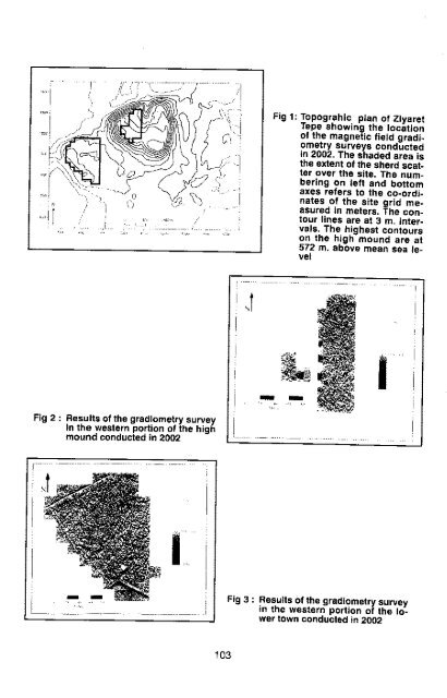
- Page 102 and 103: During the Late Bronze and Iran Age
- Page 104 and 105: epresent the metal survey pins for
- Page 108 and 109: Recent Sediments of the Tigris Rive
- Page 110 and 111: özel viIIaları süslemek için, A
- Page 112 and 113: Fig: 1Fig: 2Fig: 3 ceFig:4Fig: 5108
- Page 114 and 115: hen Brücke in Pepouza führende St
- Page 116 and 117: In den verschiedenen Fundfeldern ko
- Page 118 and 119: pepouu2002Setlioflsol Nymptıaeunı
- Page 120 and 121: ı,::-----JPepouza 2002Terrace iVAr
- Page 122 and 123: Abb:12Abb: 13Abb: 14118
- Page 124 and 125: geçirildiği Çingenetepe ilk ara
- Page 126 and 127: Yaykın yakınındaki Çalkıtepe z
- Page 128 and 129: • •• 1 1 \, .__-_-----_--....
- Page 130 and 131: .,.-------1l2L..•••Resim:_8
- Page 132 and 133: nin özellikle de Niniveh 5 seramik
- Page 134 and 135: iKiNCi BÖLGEikinci bölge olarak e
- Page 136 and 137: ESKi HOP HiRBESiBeşiri'den 10 km.
- Page 138 and 139: Resim 5: Taht-ı Reş, genel görü
- Page 140 and 141: Resim 10: Rıdvan Höyük, seramikb
- Page 142 and 143: Resim 15: Hanik Köyü Camii'ndeki
- Page 144 and 145: olmasıdır. Bunlardan biri, ii. So
- Page 146 and 147: veriler, doğu yönde iki kademeli
- Page 148 and 149: ikisi aynı usta elinde çıkan aya
- Page 150 and 151: leden söz eder ve kalenin Çubuko
- Page 152 and 153: CENGiZ, Yusuf;CUINET, Vital;ÇAY, A
- Page 154 and 155: ...Çizim 3 : Tunceli Merkez, Anbar
- Page 156 and 157:
Resim 1 : Harput iç kale, BüyükB
- Page 158 and 159:
Resim 7 : Aslanyurdu, kaya mezarıR
- Page 160 and 161:
aylarında burada yapılan bir kaç
- Page 162 and 163:
Adana ili'ndeki çalışmalara Yumu
- Page 164 and 165:
yayınlanmamış yazıtlar bu yerle
- Page 166 and 167:
Resim 1 : Karasis Dağı'nın güne
- Page 168 and 169:
Resim 5 : AlCleai'in batısındakih
- Page 170 and 171:
Resim 10 : Eyüplü Köyü'nde tüm
- Page 172 and 173:
Resim 14 : Kırobası ile Uzuncabur
- Page 174 and 175:
geçirildiği Tekirdağ il merkezin
- Page 176 and 177:
.Jiı:'",u...... DClX
- Page 178 and 179:
Ayrıca, Afyon kesimindeki araştı
- Page 180 and 181:
ğu-batı doğrultusu 20Q m. boyutl
- Page 182 and 183:
301.08.02.08 (Maltepesi):301.08.02.
- Page 184 and 185:
7. i1Ji i!·1 iiii)'\:';:·····
- Page 186 and 187:
Resim: 2Resim: 3Resim: 4182
- Page 188 and 189:
•Resim: 7- Resim: 8---" \1 \i 'f
- Page 190 and 191:
geçirilmiştir. 82x50x40 cm. ölç
- Page 192 and 193:
HaritaÇizim: 1188
- Page 194 and 195:
Resim: 4Resim: 5Resim: 6190
- Page 196 and 197:
.".•aa-.eResim: 13 _ ............
- Page 198 and 199:
şum göstermektedir. Tepenin eteğ
- Page 200 and 201:
pılan çalışma esnasında Çamk
- Page 202 and 203:
iskan izlerine rastlanmıştır. Pe
- Page 204 and 205:
Resim 1 : Karadere Köyü, BörenYa
- Page 206 and 207:
Resim 7 : Burhaniye, Ören, Yılanl
- Page 208 and 209:
Çomeklı Höyük: Meram ilçesi,
- Page 210 and 211:
Kısıkyayla Höyük: Gökhüyük'
- Page 212 and 213:
la çevrilidir. Doğu ve batısınd
- Page 214 and 215:
201.01.02.37 (Köydağı): Açık k
- Page 217 and 218:
I:::::::::;;',;\i \/"/-------------
- Page 219 and 220:
Resim: 5iResim: 6215
- Page 221 and 222:
MERSiN-siLiFKE, SEYRANlıK KÖYÜGE
- Page 223 and 224:
Kilisenin kireçtaşından yapılm
- Page 225 and 226:
6. yüzyıla tarihlendirilir 25 . B
- Page 227 and 228:
Bizans Döneminde, Hellenistik kule
- Page 229 and 230:
,ıi: :~ R--i!iPLAN.i~ cl0:1/100Çi
- Page 231 and 232:
Resim 3: Seyranlık Kilisesi,kuzey
- Page 233 and 234:
KIBYRA 2002Thomas CORSTEN*Die seit
- Page 235 and 236:
und so lst es naheliegend, anzunehm
- Page 237 and 238:
Abb.3Abb.4233
- Page 239 and 240:
ARTViN iLi-çORUH VADisi'NDEKi TARi
- Page 241 and 242:
Abdurrahman Erdem Evi (Leloğlu Evi
- Page 243 and 244:
ekten oluşan yapı veyanındaki tu
- Page 245 and 246:
elirlenen yüzeye sahiptir. Kemerin
- Page 247 and 248:
tın giriş holüne yerleştirilen
- Page 249 and 250:
an tarihi yol qüzerqahırun saptan
- Page 251 and 252:
Çizim 4: Vusufeli-Kömürlü Köy
- Page 253 and 254:
Resim 5: Yusufeli-inanlı Köyü,Mu
- Page 255 and 256:
SURVEY IN DER MYKALE2. KAMPAGNE 200
- Page 257 and 258:
Hiller von Gaertringen, die auch di
- Page 259 and 260:
dessen Tal auch im Hochsommer noch
- Page 261 and 262:
182). Hier war offenbar die Schiffs
- Page 263 and 264:
Zusammenfassung: Im Jahre 2002 wurd
- Page 265 and 266:
"t.·.. ,ı.A~" a••••••
- Page 267 and 268:
Abb. 7: Mykale-Nordwest, oberhalb Z
- Page 269 and 270:
TREBENNA VE ÇEVRESi YÜZEY ARAŞTI
- Page 271 and 272:
de kalmıştır. 195, 196 ve 197 No
- Page 273 and 274:
Belen: 2002 sezonunun en özgün bu
- Page 275 and 276:
m. uzunluğunda, 9.16 m. genişliğ
- Page 277 and 278:
önünde işlik teknesine ait küç
- Page 279 and 280:
Resim 3: Trebenna, Elmin Nekropolü
- Page 281 and 282:
Resim 9: Belen Garnizonu, kışlaRe
- Page 283 and 284:
DAGLlK KiLiKiA'OA TÜLÜ ASAR (LAMO
- Page 285 and 286:
maktadır. Bunların dışında tap
- Page 287 and 288:
şının altına soffit yapıımı
- Page 289 and 290:
dedir. Ostothek, hem alt kısmında
- Page 291 and 292:
Resim 2: Yerli kaya yüzeyineaçıl
- Page 293 and 294:
Resim 8: Tapınağın kuzey duvarı
- Page 295 and 296:
arrus ÇEVRESi 2003 YILI ARAŞTIRMA
- Page 297 and 298:
Türkçe Anlamı:"Bu kabir saide,
- Page 299 and 300:
Bitlis lli'nde, Zeydan Mahallesi, K
- Page 301 and 302:
nr-\tlı--O- i--w....ı.-l--oÇizim
- Page 303 and 304:
Resim 4: Ayrancılar Köyü,Şeyh M
- Page 305 and 306:
2002 PAsiNLER OVASI YÜZEY ARAŞTIR
- Page 307 and 308:
Mezarlık civarında düz alanda ya
- Page 309 and 310:
Övenler HöyüğüTaşkaynakve Öv
- Page 311 and 312:
\---r-ı\---"c:r -,L- ':-::==~f- --
- Page 313 and 314:
Resim: 7Resim: 8309
- Page 315 and 316:
2002 YILI ADANA iLi VE ÇEVRESi YÜ
- Page 317 and 318:
esinden seramikler toplanmıştır
- Page 319 and 320:
testilere ait parçalar; çok aşı
- Page 321 and 322:
ma mezar tespit edilmiştir. Köyü
- Page 323 and 324:
Resim 2: 8astamba, Paleolitik çağ
- Page 325 and 326:
••,,""~......~•... ŞARKÖY -
- Page 327 and 328:
·.- -.- .)~.!iResim 10: Gala Tepe,
- Page 329 and 330:
ağlı Tepecik Höyüğü, 2001 yı
- Page 331 and 332:
TEKKE TEPESi (Harita: 1. 41)Büyük
- Page 333 and 334:
ilMlk,\ii\DENIzLIEGE\\MUCIAHarita 1
- Page 335 and 336:
Resim 4: Tepecik Höyüğü çevres
- Page 337 and 338:
2002 YılıNDA DOGU ANADOLU BÖLGES
- Page 339 and 340:
PESTEKAN KANALIDeniz seviyesinden 3
- Page 341 and 342:
'-._-_..-"r"'------' }\..1~·,..,r\
- Page 343 and 344:
--40d .'214 '.2024","ÜZTEPE GÖLET
- Page 345 and 346:
Resim 4: Çuh Göleti'ne su taşıy
- Page 347 and 348:
PISIDIEN SURVEY PROJEKT:SURVEY-KAMP
- Page 349 and 350:
Vermutlich wurden beim ursprünglic
- Page 351 and 352:
Ein unk/arer monumenta/er Bau (Zoll
- Page 353 and 354:
ya Müzesi), Epigraf Raif Behrwald
- Page 355 and 356:
düzgün kesmetaş bloklardan inşa
- Page 357 and 358:
Abb 1: Pednelissos. Dievorlaufige t
- Page 359 and 360:
Abb 7: Pednelissos. Girlandenfriesd
- Page 361 and 362:
l\.\'{.Abb 11: Pednelissos. Grundri