- Page 1 and 2: T.C. KÜLTÜR BAKANLIGIANITLAR VE M
- Page 3 and 4: içiNDEKiLERSayfaErdemYÜCELAyasofy
- Page 5 and 6: Nurettin YARDıMCı1992 Şanlıurfa
- Page 7 and 8: AYASOFYA'DA TÜRK SANATıÇALIŞMAL
- Page 9 and 10: Ayasofya'nın camiye dönüştürü
- Page 11 and 12: çiniler arasından türbeyi çepe
- Page 13 and 14: Sultan III. Mehmed türbesinin seki
- Page 15 and 16: ARCHAOLOGIE UND DENKMALPFLEGE IMBER
- Page 17 and 18: des ephernaren Mosaikfundes offenge
- Page 19 and 20: dem 1\1osaikboden, um Anhaltspunkte
- Page 21 and 22: die Landgüter des kaiserlichen Hof
- Page 23 and 24: Abb. 3- RestaurierungsmaBnahmen am
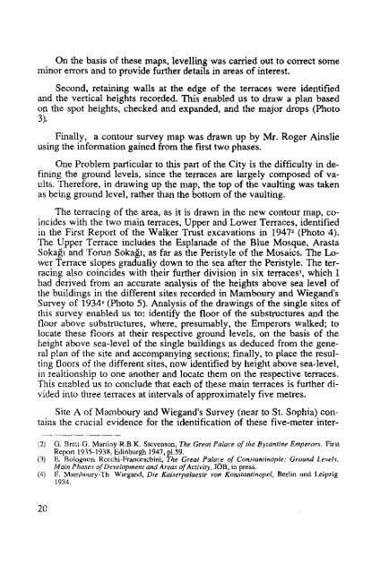
- Page 25: *THE GREAT PALACE SURVEY:THE FIRST
- Page 30: .": ..~ ."; \,)j. '"24
- Page 33: i')l.'"t,ı'"tırJLır~, ,tl'ıi 1>
- Page 38 and 39: 32............
- Page 40 and 41: 34('
- Page 42 and 43: Saha araştırmalarımız, Kubad-Ab
- Page 44 and 45: Malanda'daki yapı kalıntısında
- Page 46 and 47: Resim: 3Resim: 440
- Page 49 and 50: SURVEYS IN THE UNDERGROUNDCITIES OF
- Page 51 and 52: PURPOSES OF PLURIENNAL PROJECT OF R
- Page 53 and 54: een published on newspapers and mag
- Page 55 and 56: 2) UNDERGROUND STRUCTURESIn this se
- Page 57: 151
- Page 60 and 61: o'i: ı-ı--1'O'mt: O54
- Page 62 and 63: ))ı~UINIUJY1J ))OR~I1JŞ·S HOlJ J
- Page 64 and 65: lan bir giz değildir. Özellikle H
- Page 66 and 67: tik limanın dolgu taşlarının bu
- Page 68 and 69: Gerçekte, tahmin edildiği gibi, S
- Page 70 and 71: 5AMANDAGIAKDENizA N TA K YAKÖR F E
- Page 72 and 73: -Le second objectif consistait a et
- Page 74 and 75: est importante. Mais les effets les
- Page 76 and 77:
nommee localement Kırkmerdiven; pl
- Page 79 and 80:
SURVEY AT BUZLUCA, TRABZON VILAYET,
- Page 81 and 82:
locks, but, by contrast, above it t
- Page 83 and 84:
further study of the architecture,
- Page 85 and 86:
1992 YILI BUZLUCA ARAŞTIRMASI, TRA
- Page 87 and 88:
kilise olduğuna dair herhangi bir
- Page 89 and 90:
BUZLUCAPlan83
- Page 91 and 92:
1992 ÇANKIRI VE KASTAMONU'DAARAŞT
- Page 93 and 94:
15 [Znvoqı]ovnç Znvoqıovou Flccc
- Page 95 and 96:
105 l t lo ii rtc t o ô c KOL ı:w
- Page 97 and 98:
I\Efl .. e . EGe; * Nr. 18,12 (unbe
- Page 99 and 100:
hodischen Peraia im 2.Jh. ein Pries
- Page 101 and 102:
vgl. im al1gemeinen L. Migeotte, Le
- Page 103 and 104:
[-------------------------- ]LEOI [
- Page 105:
nacapEWV "(ile; urrt o onôAEWe;
- Page 108 and 109:
Kastamonu Ne. 1PataraNe.2102
- Page 110 and 111:
104
- Page 112 and 113:
Das Don Karafasil im ilçe Azdavay
- Page 114 and 115:
Nach Angaben der Dorfbewohner wurde
- Page 117 and 118:
DOKİMEİoN'DAN YENİ YAZITLARThoma
- Page 119 and 120:
ustanın işi olduğu (Latincesi: "
- Page 121 and 122:
Başkanı Sayın Kayahan İzmirlio
- Page 123 and 124:
Resim: 3Resim: 4117
- Page 125 and 126:
Resim: 7Resim: 8119
- Page 127:
Resim: IIResim: ıı121
- Page 130 and 131:
Am Nachmittag des 1 ı. und vom 12.
- Page 132 and 133:
sondere Beziehungen gehabt haben, d
- Page 134 and 135:
'Ayaen 'tu;cn.A-op(ıl~oç) Aptcr['
- Page 136 and 137:
den bulduk'. Üzerindeki bir satır
- Page 138 and 139:
şılamak üzere su yolunun çeşit
- Page 140 and 141:
.....~TIll'l'ASUJ>eadıı1(/IMRIl:C
- Page 142 and 143:
136
- Page 144 and 145:
ni kesin olarak belirlemek ilk bak
- Page 146 and 147:
olan Seyhan nehri havzasına kadar
- Page 148 and 149:
Göreken, Akören, Mazılık, Kayab
- Page 150 and 151:
(Harita)«. Mallos Kilikya'nın en
- Page 152 and 153:
İçel ilindeki çalışmalanmıza
- Page 154 and 155:
'
- Page 156 and 157:
Resim: 5- Akören yerleşmesinin do
- Page 158 and 159:
Resim: 9- Akören, güney kilise ap
- Page 160 and 161:
Resim: 13- Gökören'deki kilisenin
- Page 162 and 163:
Resim: 17- Tumlu kalesinin güneyin
- Page 164 and 165:
Resim: 21- Çal dağı civarındaki
- Page 166 and 167:
Resim: 25- Doğu yarısı tesviye e
- Page 168 and 169:
trict of Kocaeli in Bithynia and no
- Page 170 and 171:
Besides information of broader rele
- Page 172 and 173:
daea to cope with the most serious
- Page 175 and 176:
ARCHAEOLOGICAL SURVEY IN THEGULF OF
- Page 177 and 178:
2) The survey activity of the Missi
- Page 179 and 180:
Fig. 1- Ancient marble quarries nea
- Page 181 and 182:
@ .. ' 0'0 h" -~:,·A-··:'.:~.;"'
- Page 183 and 184:
uilt with rather smal1 stones. The
- Page 185 and 186:
Further surveys were carried out in
- Page 187 and 188:
It was possible to identify, dean a
- Page 189 and 190:
~.-ı.-r----r------,-....L'"'Ti.•
- Page 191 and 192:
Dr:-::ı~LIMESTONEQUARTZY STONEF7"I
- Page 193 and 194:
Fig. 10- Bargylia: lintel with the
- Page 195:
Fig. 13a- Milas Museum: detail ofth
- Page 198 and 199:
Mnıcvôptcç 'tfjç'Ia'tpOlCAdouç
- Page 200 and 201:
Das wiehtigste Ergebnis meiner Fors
- Page 202 and 203:
Ersatz für den ihr genommenen Ante
- Page 205 and 206:
URANİoN KENTİ VE ÇEVRESİ/STRATO
- Page 207 and 208:
tur«. Daha önce de orkestrada bul
- Page 209 and 210:
Resim: 1- Kentin girişi, kuzeydeki
- Page 211 and 212:
VESPASİANUS-TİTUS TÜNELİ VE YOL
- Page 213 and 214:
KAP/SUYU DERESİ VE TİTUS TÜNELİ
- Page 215 and 216:
ermektedir (Şekil: 16). O dönemde
- Page 217 and 218:
toplam sediment değerini bulmak i
- Page 219 and 220:
PıRAZOLLl P.A., LABOREL, I., SALIE
- Page 221 and 222:
\'-sorı ~~\)
- Page 223 and 224:
Nergizli TKU'CQijız T12BI".t.(/ii\
- Page 225 and 226:
N~
- Page 227 and 228:
Şekil: 11- Kapalı bölümün biti
- Page 229 and 230:
NsA,BJRZ Pod"D'y'"d Tou"HKL. A"op'"
- Page 231 and 232:
Şekil: 18- Seleukia Pieria kentini
- Page 233 and 234:
KARAİN ÇEVRESİNDE YENİ BİR MAG
- Page 235 and 236:
MAGARA PLANIHenüz son şeklini alm
- Page 237 and 238:
SONUÇBibiş mağarası, insanlar t
- Page 239 and 240:
•wl"_ı---~oNzwOi•
- Page 242 and 243:
Resim: 1236
- Page 244 and 245:
gemacht sondem zugleich auch die za
- Page 246 and 247:
derart gleichfönnig gebildeter Rau
- Page 248 and 249:
Abb. 2- Göllüdağ, Gebaude in K-L
- Page 250 and 251:
nin 4-5 km kuzeybatısında, Argaz
- Page 252 and 253:
İlkindi Köyü, Kayaönü/Mağra T
- Page 254 and 255:
DURBIN, G.E.S., "lron Age Pottery f
- Page 256 and 257:
Resim: 3- Kabasakal Höyüğü'nün
- Page 258 and 259:
Resim: 7- Argaz Höyüğü, Demir
- Page 260 and 261:
Resim: 11- Sinekli Höyüğü bulun
- Page 262 and 263:
Resim: 15- Karayün Höyüğü bulu
- Page 264 and 265:
Resim: 19- Tatlıcak Höyüğü, Es
- Page 266 and 267:
4. Arazide yüzey toplaması yapmak
- Page 268 and 269:
laması yapıldı. Keramiklerin gen
- Page 270 and 271:
Resim: 1- Kuşaklı, kuzey teras, z
- Page 272 and 273:
Omurtepe Höyük'ün boyutlan kuzey
- Page 274 and 275:
tabakasında tahribata neden olmuş
- Page 276 and 277:
Resim: 1- Külünçe köyünün uza
- Page 278 and 279:
Resim: 5- Omurtepe, yüzey bulun tu
- Page 280 and 281:
Resim: 7- Taşbasan'dan genel bir g
- Page 282 and 283:
Resim: 11- Köprü1ü Höyük yüze
- Page 284 and 285:
Resim: 13- Çamurlu Höyük ve yama
- Page 286 and 287:
i/R.12em.[ıç/ ///)5OR.13em.?~ıh~
- Page 288 and 289:
Resim: ı 9- Tel Kazane yüzey bulu
- Page 291 and 292:
1992 YILI ORDU-MESUDİYE YÜZEYARA
- Page 293 and 294:
kılı olup orta pişkinliktedir. D
- Page 295 and 296:
YARDERE-BAHÇELER (UZUNKAVAK) (Hari
- Page 297 and 298:
~~,~~2.~:ıl"~ .S\~·7:7~ .....,;z'
- Page 299 and 300:
Resim: 3- Ilışar II, güneydenRes
- Page 301 and 302:
Resim: 7- Atyolu buluntulanndan ör
- Page 303 and 304:
Resim: 11- Fırışlık bu1untu1ar
- Page 305 and 306:
Resim: 15- Azmikale, güneybatıdan
- Page 307 and 308:
1992 YILI ISPARTA-GELENDOSTYÜZEY A
- Page 309 and 310:
mektedir-, Biz de, son derece tahri
- Page 311 and 312:
• Kıyo.kdede... ,..Gcırip..~~ğ
- Page 313 and 314:
Resim: 3- Taşlı Höyük:, doğuda
- Page 315 and 316:
309
- Page 317 and 318:
1992 YıLıNDA iç ANADOLU'DA YÜR
- Page 319 and 320:
sında Türk mezarlığı vardır.
- Page 321 and 322:
14. Hôyük-Kınkkuyu (Resim: 1-14)
- Page 323 and 324:
u höyüğün, doğu-batı istikame
- Page 325 and 326:
mel taşlan ve kaçak kazı izleri
- Page 327 and 328:
terası vardır. Derlenen çanak-ç
- Page 329 and 330:
48. Külhöyük-SuyugüzelAnkara il
- Page 331 and 332:
-.§~325
- Page 334 and 335:
, lOemi===, ' . 2.5.8.9.11.12.14O 1
- Page 336 and 337:
CC5IJOf o r,'4o10cm: , 5.7.9,10,13,
- Page 338 and 339:
: ZCJ i ii~\ t U iC\ ,,~) i v;' '~i
- Page 340 and 341:
(::cc3i\0 i U15~"o 10",! ! 2-5 .9.
- Page 342 and 343:
\0Ji 13~f w2l 9 . 1"'-".:'-'H'o !'i
- Page 344 and 345:
dır. Baraja en yakın köy, Hacı
- Page 346 and 347:
üyük değildir (Resim: 5). Ancak
- Page 348 and 349:
uzunluğunun 70 m, genişliğinin d
- Page 350 and 351:
VJt.J''''''.... ,KARADEt'lIZ,.",..J
- Page 352 and 353:
Çizim: 1- Reşan barajı ve yakın
- Page 354 and 355:
Çizim: 3- Sünnet Nebi barajı ve
- Page 356 and 357:
Göresor T.2339Çizim: 5- Gövelek
- Page 358 and 359:
Resim: 1- Sulann getirdiği toprak
- Page 360 and 361:
Resim: 5- Sünnet Nebi GölüResim:
- Page 362 and 363:
Resim: 9- Gövelek köyü ve gölü
- Page 364 and 365:
Resim: 13- Duvarın üstünde halk
- Page 366 and 367:
ulunmuştu. Türkiye'de özellikle
- Page 368 and 369:
ilgili keramik malzeme (Resim: 6,
- Page 370 and 371:
son çalışmasında, bu boyalılar
- Page 372 and 373:
Dinkha O O Hasanlu~\~'~-,\~o:::~~VJ
- Page 374:
Resim: 3- Kazılmış mezarlarResim
- Page 377 and 378:
Jı l"''ı ....._-- //'---'---,,(2.
- Page 379 and 380:
i· i 'i?~,ç~~" \Iİ i \J ı ('/'/
- Page 381 and 382:
:~:0..i
- Page 383:
Resim: 12- Nurettin köyü kurganla
- Page 386 and 387:
maktadır? (Harita: 1). Köyün yak
- Page 388 and 389:
Urartu karakteri gösteren diğer k
- Page 390 and 391:
getirilmemişolmakla beraber, Urart
- Page 392 and 393:
üzere, dört bir yanı Urartu kal
- Page 394 and 395:
, Çizim: 1388
- Page 396 and 397:
Resim: 3Resim: 4390
- Page 398 and 399:
Resim: 7Resim: 8392
- Page 400 and 401:
Resim: IIResim: 12394
- Page 403 and 404:
MYRA, TLOS VE PHASELİs TYATRüLARI
- Page 405 and 406:
Sahnebinası detaylı incelendiğin
- Page 407 and 408:
Yirmi oturma sırası bulunan kavea
- Page 409 and 410:
R~,im ; J. Myra uyatrosunun tonozla
- Page 411 and 412:
KELENDERİs ANIT MEZARINDAKİFİZİ
- Page 413 and 414:
Bu sorunlar çeşitli yükler karş
- Page 415 and 416:
lardaki eksik ve bozunan taşlar da
- Page 417:
Resim: 4- Anıt mezar, genel görü
- Page 420 and 421:
projesinin ikinci evresinde ise, Bu
- Page 422 and 423:
Konservasyon ProjesiDemir Buluntula
- Page 424 and 425:
Alkali sülfit işlemi tamamlanmı
- Page 427 and 428:
DIE KONSERVIERUNG DER KNIDISCHENFRE
- Page 429 and 430:
Damit werden die Friese vor weitere
- Page 431 and 432:
An den markantesten Punkten wurden
- Page 433 and 434:
terrutscht. Deshalb wurden als Abst
- Page 435 and 436:
BALBOURA RESEARCH PROJECT 1992John
- Page 437 and 438:
Just above the north end of lake th
- Page 439 and 440:
clearly attested in the nearby Elma
- Page 441 and 442:
Fig. 1- Gölçük, votive relief sh
- Page 443 and 444:
ATTİKA SİYAH FiGÜR SERAMİGİNİ
- Page 445 and 446:
6. yüzyılın 2. çeyreğine aitti
- Page 447 and 448:
Chios (Sakız) adasının 6. yüzy
- Page 449 and 450:
LidyaLidya'nın merkezi Sardeis'in"
- Page 451 and 452:
KX Ressamı ve çevresinin üretti
- Page 453 and 454:
Resim: 1- Küçük olpe, İst. Ark.
- Page 455 and 456:
Resim: 5- Amphora parçalan, Bayrak
- Page 457:
Resim: 9- Lekythos, İst. Ark. Müz
- Page 460 and 461:
avine about 15 m deep that lay betw
- Page 462 and 463:
nious; but his distinction between
- Page 464 and 465:
iipart of*"(Jl00,. .. _ .t'L:~::it=
- Page 466 and 467:
ii1 i1r - -- - - - - - - - - - -4ii
- Page 468 and 469:
Fig. 6- Aspendos Basilica; general
- Page 470 and 471:
Fig. 10- Aspendos Basilica; lower,
- Page 472 and 473:
Bu "çevre yollanndan" batıdaki il
- Page 474 and 475:
Roma çağı onanınına ait ön du
- Page 476 and 477:
AuBerdem waren aber Wege au8en um d
- Page 478 and 479:
vor dem römischen Umbau eingetrete
- Page 480 and 481:
~~ATHENA-~Q1"1 i Ilk. ! ıL.&',2'6;
- Page 482 and 483:
...........~..·"·~-..°ı", ~ft·
- Page 484 and 485:
o IOmi i i i i i i i iAbb. 7- Prien
- Page 486 and 487:
uh6
- Page 489 and 490:
PROKONNESOS- 1992 ÇALIŞMALARINuş
- Page 491 and 492:
lamaktaydılar.tam işliOcaklarda s
- Page 493 and 494:
Böylece Geç Antik Çağ'da çeşi
- Page 495 and 496:
mıştır (Şekil: 6 Oc. 313 ve No.
- Page 497 and 498:
SARAYLAR· YILLIK 8ULUNTULARIN ARTI
- Page 499 and 500:
~~+ ~~~~E..",--fL
- Page 501 and 502:
RED LO (JUAmy 5AMJ1.EBLUE = ARTEFAC
- Page 503 and 504:
· Resim: 3- Tam işli, Korint çif
- Page 505 and 506:
Resim: 7- Yarı-işli (evre B) Geç
- Page 507 and 508:
Resim: 11- Roma İmparatorluk çağ
- Page 509 and 510:
Resim: 15- çatı mahya kiremiti Oc
- Page 511 and 512:
AKDENİZ BÖLGESİ ANTİK ÇAG ZEYT
- Page 513 and 514:
Trapetumlar ve bunlara ilişkin yan
- Page 515 and 516:
Yuvarlak pres yatağı ve önde bir
- Page 517 and 518:
nan taş ağırlıklar yaygın biç
- Page 519 and 520:
Resim: 3- Çatıören. ezme çukuru
- Page 521 and 522:
Resim: -t; Kaunos, yağ i~liği, tr
- Page 523 and 524:
Resim: 11- Mylome yağ işliğl pre
- Page 525 and 526:
Resim: 15- Hasanaliler, şarap işl
- Page 527 and 528:
ENEZ AYASOFYASI FRESKO ARAŞTIRMALA
- Page 529 and 530:
eyaz renkler görülür. Gövdeden
- Page 531:
Resim: 3- Sağ yan kapı üzerinde,
- Page 534 and 535:
sesler ve bunlann kabartınalar üz
- Page 536 and 537:
yalar'daki sahnelerde, Yunan ikonog
- Page 538 and 539:
Şekil: lO'daki yazıtta bulunan TE
- Page 540 and 541:
Bu şekilde, yere düşerken hafif
- Page 542 and 543:
Görüldüğü gibi, bölgede 1964-
- Page 544 and 545:
,~i,'. '~'!.'.C? ,,'",AOAMKA'ılILA
- Page 546 and 547:
Şekil: 3- Adamkayalar kabartmalar
- Page 548 and 549:
Şekil: 7- Ölü ziyafeti sahnesi (
- Page 550 and 551:
Şekil: 11- Paltolu adam (solda, A4
- Page 552 and 553:
Şekil: 15Şekil: 15- Çantali adam
- Page 554 and 555:
Yerleşimin kuzeye ve doğuya doğr
- Page 556 and 557:
tEast RangeDOCU KıSıMSouth Rangec
- Page 558 and 559:
Resim: 5Resim: 6552
- Page 560 and 561:
gun olduğu zamanlarda. ise, özelo
- Page 562 and 563:
Resim: 3- Çevrili alanlar. Kale so
- Page 565 and 566:
ANADOLU ORTA ÇAO KALELERİ ETÜDÜ
- Page 567 and 568:
Buna rağmen, sonradan eklenen iki
- Page 569 and 570:
. A circuit wall around the lower c
- Page 571 and 572:
565
- Page 573 and 574:
Resim: 3Resim: 4567
- Page 575 and 576:
Resim: 7Resim: 8569
- Page 577 and 578:
1992 yıLıNDA KÜTAHYA, BİLECİK
- Page 579 and 580:
10.5 m yüksekliğindedir. Höyüğ
- Page 581 and 582:
dece Klasik devir malzemesi ele ge
- Page 583 and 584:
Esnemez (38)Daha önce tanıtılmay
- Page 585 and 586:
Höyük (8) gelmektedir. Yerleşme
- Page 587 and 588:
YERLEŞME YERLERİNİN liSTESİ(Res
- Page 589 and 590:
Resim: 1- Hacıkebir, kuzeybatıdan
- Page 591 and 592:
Resim: 5- Subak, doğudanResim: 6-
- Page 593 and 594:
Resim: 9- İkizhüyük, çanak çö
- Page 595 and 596:
Resim: 13- Hacıhamza- canak çöml
- Page 597 and 598:
-L°'\.". \"~\~\....,"\,tliiIIi-i1\


