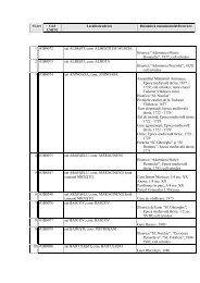
pdf (15 MB) - cIMeC
pdf (15 MB) - cIMeC
pdf (15 MB) - cIMeC

You also want an ePaper? Increase the reach of your titles
YUMPU automatically turns print PDFs into web optimized ePapers that Google loves.
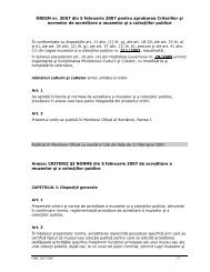
Cronica cercetărilor arheologice din România – campania 2006<br />
3. Dan Buzea, Gheorghe Lazarovici, Descoperirile Cucuteni-<br />
Ariuşd de la Păuleni Ciuc – Ciomortan „Dâmbul Cetăţii”.<br />
Campaniile 2003 – 2005. Raport Preliminar. Angustia 9, 2005,<br />
p. 25 – 88<br />
4. Gheorghe Lazarovici: New Archaeological Research about<br />
Cucuteni–Ariuşd Culture. Transylvania. În: Tripolian<br />
Settlements – Gigants. The international symposium material,<br />
Kiev, 2003, p. 217-231<br />
Abstract:<br />
The prehistorically settlement from Păuleni Ciuc is known<br />
under the name of Ciomortan or Şoimeni. The settlement is<br />
situated at about 8 km northeast from Miercurea-Ciuc city and<br />
at about 1 km north-east from Şoimeni village, in the place<br />
called by the villagers Várdomb (Dâmbul Cetăţii).<br />
The settlement has oval shape, with a surface of about 60<br />
(north - south) x 90 (east - west). The site’s emplacement in<br />
this point was well choose by the prehistorically communities.<br />
The settlement is well hidden between the hills from the west<br />
slope of Ciucului Mountain and it offers a good visibility over<br />
the Ciuc Valley.<br />
The settlement was discovered in the interwar period by Al.<br />
Ferenczi who included it in the repertory of Dacian fortresses<br />
from Transylvania. Between 1956, 1960 and 1967<br />
archaeological researches were made here by Székely Zoltán.<br />
The settlement was inhabited in the Early Copper Age<br />
(Cucuteni-Ariuşd and Bodrogkeresztur Cultures), in the Late<br />
Copper Age (Coţofeni Culture) and in the Middle Bronze Age<br />
(Costişa - Ciomortan and Wietenberg Cultures).<br />
Between 1999 and 2006 the director of The Museum of<br />
Eastern Carpathians from Saint George, Valeriu Cavruc,<br />
coordinated the archaeological researches.<br />
In the 2006 campaign were researched the traces of three<br />
complexes which were used to inhabit:<br />
House No. 21, has a rectangular shape, the dimensions of 3.8<br />
- 4 x 2.5 - 3 m with every corner lightly rounded. After the<br />
house was put on fire, the floor burnt and became red with<br />
shades of brown and black a.<br />
Complex No. 23 (hut). The complex’s pit had the<br />
dimensions of about 2.2 x 2.8 m and it was oriented on the<br />
direction NE-SV. In its northern side, the complex’s pit has a<br />
channel (ditch) with a length of about 0.8 m and a breadth of<br />
0.4 m (it probably represents the place used as entrance in the<br />
house “hut”).<br />
House No. 24. The house was disposed on the direction<br />
NE-SV. It had a rectangular shape with the dimensions of<br />
about 4,5 x 4 m. A part of the floor’s smooth daub was very<br />
well kept; it has 4.5 x 1.5 m. The house was discovered in the<br />
northern side of the settlement, were the ground is inclined.<br />
Pit No. 8. The pit has a circular shape with the diameter of<br />
1.3 m; the walls are vertical towards the flat base. The pit was<br />
dogged approximately 0.4 m on the hill’s natural rock. The<br />
padding was formed from earth mixed with stones, ceramic<br />
fragments, carbonized wood and ashes.<br />
Pit No. 9 was partially researched. The pit in its western<br />
side has a semicircular shape with the diameter 1.4 m. In<br />
section, the pit’s profile has the shape of a “clepsydra” with a<br />
lightly spherical base; it was dogged at about 1.2 m on the hill’s<br />
natural rock. The pit’s padding is compound of stony earth with<br />
a brown-yellowish colour, mixed with brown earth combined<br />
with remains of carbonized wood, burnt wood and a few traces<br />
of ashes.<br />
364<br />
Post holes.<br />
There have been researched 35 post pits, of different types<br />
and shapes. Some of them belong to the house’s infrastructure<br />
and others belong probably to some interior arrangements.<br />
Fire hearths<br />
There have been discovered and researched 3 fire<br />
installations; Hearth No. 25, Hearth No. 26 and Hearth No. 27.<br />
All researched hearths had a stone made pavement over<br />
which it was applied a clay stratum. Another hearth or house<br />
floor was partially researched; it remains to be set on our next<br />
archaeological research.<br />
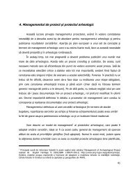
Simultaneously with the archaeological research an<br />
experiment was realised concerning the construction o a fire<br />
installation (hearth) after the type of those discovered inside<br />
the Cucutenian houses.<br />
187. Şuţeşti, com. Şuţeşti, jud. Brăila<br />
Punct: Popină, Val<br />
Cod sit: 44<strong>15</strong>9.01, 44<strong>15</strong>9.02<br />
Autorizaţia de cercetare arheologică preventivă nr.<br />
422/2006<br />
Colectiv: Valeriu Sîrbu - responsabil, Stănică Pandrea,<br />
Viorel Stoian (M Brăila), Costin Croitoru (MJI Galaţi)<br />
Punctul „Val”<br />
Situl este situat la marginea vestică a satului Şuţeşti şi<br />
urmează un traseu ce începe la marginea cimitirului satului, în<br />
stânga DN 22 Brăila – Rm. Sărat, şi se mai poate observa pe<br />
un traseu de cca. 1 Km. Cercetarea preventivă s-a impus<br />
datorită riscului distrugerii acestui val de către activitatea<br />
cotidiană a locuitorii comunei: la capătul nord-estic al valului se<br />
află cimitirul satului, iar locuitorii au început să sape în el<br />
pentru a-şi înmormânta defuncţii, iar pe traseul său au fost<br />
executate patru căi de acces spre zone cultivată deoarece el<br />
închide, practic, accesul spre lunca Buzăului.<br />
Primele informaţii despre acest sistem de fortificaţii le<br />
avem de la Pamfil Polonic. Acesta a menţionat existenţa unui<br />
val, cu l de 20 m şi h de 2-4 m, şi a două şanţuri (primul cu l de<br />
11 m şi ad. de cca. 2 m, iar al doilea şanţ cu l de 7 m şi ad. de<br />
cca. 1 m), ce se întindeau pe o distanţe de cca. 900 m.<br />
Anterior săpăturii a avut loc o evaluare de teren, efectuată de<br />
Stănică Pandrea, Viorel Stoian şi Costin Croitoru, în perioada<br />
14–27 august 2007.<br />
Obiectivele acestei cercetări preventive au fost identificarea<br />
traseului păstrat al fortificaţiei şi modul de amenajare a valului<br />
şi a şanţului.<br />
Valul. Este dificil de stabilit întinderea sa iniţială întrucât a fost<br />
puternic afectat de-a lungul timpului; dacă ar fi să judecăm<br />
utilitatea sa, atunci el ar fi trebuit să aibă minimum 10 Km,<br />
adică să bareze accesul spre două vaduri naturale ce coborau<br />
în lunca Buzăului, izolând, astfel, o suprafaţă de câteva zeci de<br />
hectare. Acum se mai observă pe o L de cca. 1 Km, la V de<br />
DN 22 Brăila – Rm. Sărat, având orientarea NE-SV, la E de<br />
acest drum naţional el a fost distrus de localnici când şi-au<br />
ridicat locuinţele.<br />
În zonele unde valul se păstrează cel mai bine el are o<br />
formă trapezoidală, cu h de 2,5-3 m, cu baza de cca. <strong>15</strong> m şi<br />
cu partea superioară, aproape plată, lată de cca. 6 m. În<br />
vederea cercetării lui s-a trasat secţiunea S1=36 x 2 m, din