84 | ARTIGOSAS NOVAS ÁREAS DE EXPANSÃONO INÍCIO DO SÉCULO XXPoucos anos depois da primeira expansão para oAltinho, o governador Eduardo Galhardo (1900-1905) decidiu abrir uma nova via, a avenidade circunvalação que ligava as Fontainhas aoaglomerado de Taleigão situado a sul-poente dePangim no caminho para a foz do Mandovi, e a SantaInês. Contornando todo o monte a sul de Pangim,o objectivo era que “levasse à construção de casaspor toda essa encosta 68 ”, abrindo as Fontainhas,a sul e oeste, melhorando as suas condições desalubridade. Esta avenida, desenhada pelo capitãoJosé Norton de Matos 69 , na época director daRepartição de Agrimensura, foi inaugurada em 1904e designada por Avenida 25 de Junho 70 . No entanto,a urbanização desta área só se realizou efectivamentea partir de após 1961, com a integração do territóriode Goa na União Indiana.Provavelmente na mesma época, uma outra zonade expansão foi desenhada abrangendo as áreas doCampal e de Miramar, ou seja, toda a área poenteda cidade. Em 1904 o administrador do Concelhodas Ilhas referia que se tinha de “proceder aoprolongamento da alameda de Gaspar Dias atéCaranzalém, dando origem á construção d’um bairro”71 . O facto de se pensar numa zona de expansãopara a área da actual Miramar, continuação naturaldo Campal, juntamente com a publicação, emFevereiro de 1903, da Lista de nomes de ruas, largos,travessas e becos da cidade de Nova Goa 72 , onde aparecemjá referenciadas as diversas ruas do Campal,leva a crer que esta expansão já estava planeadadesde os primeiros anos do novo século.O Campal situa-se entre a Ponte de Minerva e aPonte de Santa Inês 73 como eram designadas em1870. E embora não se conheça a autoria do planoque lhe deu forma, o início das obras data de 1907. 74Uma avenida continuava a marginal ao rio Mandoviaté à Rua Gaspar Dias 75 , esta já existente na zonacentral da cidade, estruturando uma série de lotesque dividiam o Campo de D. Manuel. O directordas Obras Públicas, Pedro Bessone Bastos, mencionouem 1909, ”obras de construção de passeios,aterro, regularização, de caldeiras, arborização, etc.,(…) na Avenida Ayres d’Ornellas e no novo bairrono Campo de D. Manuel” 76 . O tipo de obra referidomostra que a construção da avenida já se encontravanuma fase terminal.<strong>THE</strong> NEW AREAS OF EXPANSIONIN <strong>THE</strong> EARLY 20 TH CENTURYA few years after the fi rst expansion of the city in theAltinho direction, the Governor Eduardo Galhardo(1900-1905) decided to open up a ring roadconnecting Fontainhas to the village of Taleigao,to the southwest of Panjim towards the Mandovi’smouth, and to Santa Inês. As it went round the wholehill to the south of Panjim, the aim was that it wouldlead to the construction of housing on the wholeslope 68 , thus opening up to the south and west andimproving the health and hygiene conditions. Thisavenue, designed by captain José Norton de Matos 69 ,who was, at the time, Director of the Departmentof Land Surveying, was opened in 1904 and giventhe name of Avenida 25 de Junho 70 . However, theurbanisation of the area only effectively took placeafter 1961 with the integration of Goa in the IndianUnion.Most likely at the same time, another area of expansionwas planned that included the areas of Campaland Miramar, i.e. the whole western zone of thecity. In 1904, the administrator of the Municipalityof Ilhas, reported that one had “to proceed with theextension of Gaspar Dias avenue to Caranzalem,giving rise to the construction of a neighbourhood”71 . The fact that one was thinking of expandinginto the area of what is now Miramar, thenatural continuation of Campal, together with thepublication, in February 1903, of a “list of names ofstreets, squares, side streets and lanes in the city ofNew Goa” 72 , in which the various streets in Campalwere included, leads to believe that this expansionwas already planned in the early years of the newcentury.Campal lies between Minerva and Santa Inêsbridges 73 , the names they were known by in 1870.Although we do not know who drew up the plan,we do know the respective work was begun in1907 74 . An avenue continued the waterfront roadon the banks of the River Mandovi as far as Ruade Gaspar Dias, that already existed in the centralzone of the city 75 , and structured a string of plotsthat divided up Campo de Dom Manuel.In 1909 the Director of Public Works, PedroBessone Bastos, referred to “construction work onpavements, landfi lls, levelling, tree pots, the plantingof trees, etc. (...) on Avenida Ayres d’OrnellasMURPHY 2 | Julho 2007Pangim entre o Passado e a Modernidade
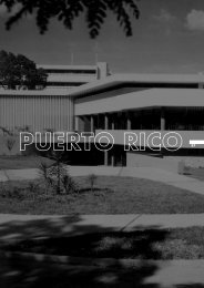
ARTICLES | 85{Fig 13}Ruas de Santa Inez e do Campal. Fotografia Sousa & Paul(s.d. / in’ cio do século XX). [PCL]Ruas de Santa Inez and Campal. Photo Sousa & Paul(undated / beginning of the 20th century). [PCL]Panjim between the past and modernityJuly 2007 | MURPHY 2