Create successful ePaper yourself
Turn your PDF publications into a flip-book with our unique Google optimized e-Paper software.
Rede DGPS (Differential GPS) Portuguesa<br />
Sardinha Monteiro<br />
PRIMEIRO-TENENTE<br />
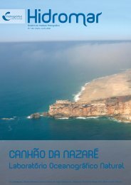
Resumo Foi lança<strong>do</strong>, em Maio de 2001, o Concurso Público Internacional para a aquisição e instalação da componente<br />
Continental da rede DGPS Portuguesa, constituída por uma Estação de Controlo e duas Estações DGPS, que se prevê<br />
comecem a transmitir correcções diferenciais em 2002.<br />
A transmissão de correcções diferenciais permite eliminar a maior parte <strong>do</strong>s erros <strong>do</strong> GPS e melhorar significativamente<br />
a integridade <strong>do</strong> serviço: enquanto o GPS não fornece avisos de integridade em tempo-real, a utilização de Estações DGPS –<br />
que monitorizam permanentemente a qualidade <strong>do</strong>s sinais <strong>do</strong>s satélites visíveis – permite notificar os utiliza<strong>do</strong>res de qualquer<br />
avaria ou falha em menos de 15 segun<strong>do</strong>s. No entanto, o fim da Selective Availability em Maio de 2000, ao permitir<br />
uma melhoria na exactidão <strong>do</strong> GPS natural, obrigou a uma re-avaliação <strong>do</strong>s benefícios que justificavam a existência de serviços<br />
diferenciais. Esses benefícios <strong>do</strong> DGPS serão discuti<strong>do</strong>s e apresenta<strong>do</strong>s neste artigo, com o fim de mostrar que a opção<br />
pelo DGPS é, ainda, a mais adequada e útil aos navegantes, em águas Portuguesas.<br />
Vai-se descrever, também, a arquitectura prevista para a rede DGPS Portuguesa, que, além das Estações no Continente,<br />
inclui uma Estação DGPS em cada um <strong>do</strong>s Arquipélagos <strong>do</strong>s Açores e da Madeira. Espera-se lançar o Concurso Público Internacional<br />
para a aquisição das Estações DGPS <strong>do</strong>s Açores e da Madeira no início de 2003.<br />
Abstract The tender for the acquisition and installation of the Continental component of the Portuguese DGPS<br />
network has been launched in May 2001. This component will be composed of a Control Station and two DGPS Stations,<br />
which are expected to start broadcasting differential corrections in 2002.<br />
The transmission of differential corrections allows elimination of most of the errors of GPS and improves significantly<br />
the integrity of the service: while GPS <strong>do</strong>es not provide instantaneous integrity warnings, the use of DGPS Stations – which<br />
monitor permanently the signals of the visible satellites – enables the timely warning of any malfunction or failure in less<br />
than 15 seconds. However, the discontinuation of Selective Availability in May 2000, which led to an improvement in standalone<br />
GPS accuracy, urged a re-evaluation of the premises that justified differential services. DGPS benefits for mariners<br />
will be discussed and presented in this paper, with the aim of showing that the option to embrace DGPS is still the most<br />
adequate and useful for mariners, in Portuguese waters.<br />
In this paper, the architecture of the Portuguese DGPS network will also be described. This network includes, besides<br />
the mainland stations, one DGPS Station in each of Azores and Madeira archipelagos. The tender for the acquisition and<br />
installation of Azores and Madeira DGPS Stations is expected to be launched in the beginning of 2003.<br />
1. Importância de um posicionamento<br />
muito exacto<br />
Apreocupação com a segurança marítima e a segurança<br />
da navegação têm aumenta<strong>do</strong> muito nos últimos<br />
anos. A opinião pública, Portuguesa e Mundial,<br />
está cada vez mais sensível e atenta aos acidentes marítimos<br />
e aos seus efeitos sobre o meio ambiente. A costa<br />
Portuguesa é uma via de acesso prioritária, tanto para o<br />
Norte da Europa como para o Mediterrâneo, conforme se<br />
pode depreender da figura 1, que ilustra o tráfego marítimo<br />
de petroleiros em 1994.<br />
Os únicos da<strong>do</strong>s consistentes sobre o tráfego marítimo<br />
nas nossas águas foram recolhi<strong>do</strong>s pelo <strong>Instituto</strong><br />
<strong>Hidrográfico</strong>, através de uma viatura equipada com um<br />
radar de controlo de tráfego marítimo, no já longínquo<br />
ano de 1987 [Ref. 1]. Foram feitas contagens nos Cabos<br />
de S. Vicente, Roca e Carvoeiro, ten<strong>do</strong>-se obti<strong>do</strong> os<br />
seguintes resulta<strong>do</strong>s:<br />
❚❘ Cabo de S. Vicente: 76 navios/dia (27.700 navios/<br />
/ano)<br />
❚❘ Cabo da Roca: 62 navios/dia (22.600 navios/ano)<br />
❚❘ Cabo Carvoeiro: 59 navios/dia (21.500 navios/<br />
/ano)