Plano de Manejo Completo - Secretaria do Meio Ambiente ...
Plano de Manejo Completo - Secretaria do Meio Ambiente ...
Plano de Manejo Completo - Secretaria do Meio Ambiente ...

You also want an ePaper? Increase the reach of your titles
YUMPU automatically turns print PDFs into web optimized ePapers that Google loves.
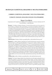
7420000<br />
7413000<br />
7406000<br />
7399000<br />
1<br />
Estrada<br />
2<br />
Estrada<br />
3<br />
Santa<br />
4<br />
da Vista<br />
Ribeirão Santa Inês<br />
Rosa<br />
19<br />
Alegre<br />
Córrego<br />
328000<br />
5<br />
328000<br />
6<br />
Cabuçu<br />
7<br />
8<br />
9<br />
Rio Cabuçu <strong>de</strong> Baixo<br />
10<br />
Reservatório<br />
Paiva<br />
Castro<br />
Reservatório<br />
Águas<br />
Claras<br />
Estrada<br />
Santa<br />
Núcleo<br />
Pedra Gran<strong>de</strong><br />
17<br />
14<br />
15<br />
18 16<br />
12<br />
13<br />
Inês<br />
Córrego<br />
11<br />
<strong>do</strong><br />
Ribeirão<br />
Avenida<br />
Bispo<br />
Córrego Vila Amália<br />
Núcleo<br />
Águas Claras<br />
das Águas<br />
Parada<br />
Pinto<br />
Córrego<br />
Claras<br />
Inês<br />
Juqueri<br />
Avenida Santa<br />
Estrada<br />
da<br />
Roseira<br />
£ £<br />
£<br />
£ £ 53<br />
52 £ 51<br />
£<br />
Ribeirão<br />
Av.<br />
58 56<br />
57 55<br />
50<br />
54<br />
49<br />
Sen.<br />
335000<br />
José Ermirio <strong>de</strong> Moraes<br />
47<br />
£<br />
22<br />
21<br />
20<br />
335000<br />
27<br />
23<br />
24<br />
25<br />
Estr. da Cassununga<br />
Tremembé<br />
£<br />
Córrego São Pedro<br />
62<br />
26<br />
28<br />
Reservatório<br />
<strong>do</strong><br />
Engorda<strong>do</strong>r<br />
66<br />
£<br />
65<br />
Av.<br />
£<br />
Cel.<br />
61<br />
33<br />
29<br />
30<br />
Sezefre<strong>do</strong><br />
32<br />
31<br />
34<br />
35<br />
41<br />
40<br />
38 37<br />
36<br />
39<br />
Núcleo<br />
Engorda<strong>do</strong>r<br />
Fagun<strong>de</strong>s<br />
Ro<strong>do</strong>via Fernão Dias<br />
Ribeirão<br />
Engorda<strong>do</strong>r<br />
Rio<br />
46<br />
45<br />
Cabuçu<br />
<strong>de</strong><br />
Ribeirão<br />
1 - Represa da Cuca<br />
2 - Marco da RAE<br />
Cima<br />
3 - Represa <strong>do</strong> Canivete<br />
4 - Aqueduto<br />
Barrocada<br />
5 - Represa <strong>do</strong> Depósito I<br />
7 - Represa <strong>do</strong> Depósito ll<br />
7 - Represa <strong>do</strong> Manino<br />
8 - Marco da RAE<br />
9 - Represa <strong>do</strong> Ytaguassu<br />
10 - Aqueduto <strong>do</strong> Matheus<br />
11 - Represa <strong>do</strong> Bispo<br />
12 - Vestígio <strong>de</strong> sinais em rocha<br />
13 - Caixa <strong>de</strong> concreto<br />
14 - Vestígio <strong>de</strong> aqueduto<br />
342000<br />
15 - Aqueduto Passagem <strong>de</strong> Montesinos<br />
16 - Vestígio <strong>de</strong> edificação<br />
15 - Aqueduto Passagem <strong>de</strong> Montesinos<br />
18 - Aqueduto <strong>do</strong> Bispo<br />
19 - Represa da Divisa<br />
20 - Represa no 1 <strong>do</strong> Cassununga<br />
21 - Represa no 2 <strong>do</strong> Cassununga<br />
22 - Represa no 3 <strong>do</strong> Cassununga<br />
£<br />
64<br />
342000<br />
59<br />
44<br />
£<br />
43<br />
Reservatório<br />
<strong>do</strong><br />
Cabuçu<br />
42<br />
Núcleo Cabuçu<br />
Ro<strong>do</strong>via Presi<strong>de</strong>nte Dutra<br />
Rio Tiête<br />
Ribeirão<br />
23 - Caixa <strong>de</strong> respiro <strong>do</strong> encanamento<br />
<strong>do</strong>s<br />
Macacos<br />
Córrego<br />
24 - Caixa <strong>do</strong> Sifão no 1 e casa <strong>do</strong> guarda parque<br />
25 - Caixa <strong>do</strong> Sifão no 2<br />
26 - Aqueduto aéreo - atravessa a grota<br />
27 - Encanamento com as marcas Causer Hopkins<br />
28 - Represa <strong>do</strong> Cachoeiro<br />
29 - Barragem <strong>do</strong> Engorda<strong>do</strong>r<br />
30 - Caixa <strong>do</strong> Gonçalves<br />
31 - Antigo Tanque <strong>do</strong> Engorda<strong>do</strong>r<br />
32 - Antiga Represa no 01<br />
33 - Antiga Represa no 02<br />
34 - Aqueduto - trecho aéreo<br />
35 - Aqueduto - trecho em superfície<br />
36 - Casa da Bomba<br />
37 - Casa da Cal<strong>de</strong>ira com forno alemão<br />
38 - Vestigios <strong>de</strong> Chaminé<br />
39 - Casa da Bomba secundária<br />
40 - Equipamento marítimo a diesel - auxiliar<br />
da bomba a vapor<br />
41 - 2 bombas a vapor <strong>de</strong> 1898, fabrica<strong>do</strong> pela<br />
Robey & Co.<strong>de</strong> Li<br />
42 - Barragem <strong>do</strong> Cabuçu<br />
43 - Se<strong>de</strong> administrativa<br />
44 - Clarifica<strong>do</strong>r<br />
<strong>do</strong> Pari<br />
Estrada<br />
<strong>do</strong>s<br />
Veigas<br />
349000<br />
45 - Represa <strong>do</strong> Barrocada e Clarifica<strong>do</strong>r<br />
46 - Clarifica<strong>do</strong>r<br />
47 - Caixa <strong>de</strong> Juncão <strong>do</strong> Guapira<br />
48 - Represa <strong>do</strong> Toucinho<br />
49 - Vestígios <strong>de</strong> edificação<br />
50 - Reservatório A <strong>de</strong> acumulação<br />
51 - Casa das Máquinas<br />
52 - Represa <strong>do</strong> Guatemy<br />
53 - Edificação com vestígios <strong>de</strong> uma<br />
bica <strong>de</strong> água<br />
54 - Comporta <strong>de</strong> entrada das águas <strong>do</strong><br />
Cassununga<br />
55 - Vestígios <strong>de</strong> encanamento com a marca<br />
<strong>do</strong> fabricante<br />
56 - Reservatório A <strong>de</strong> Acumulação<br />
57 - Portal <strong>de</strong> Entrada e Bica em ferro fundi<strong>do</strong><br />
58 - Estação <strong>de</strong> Acumulação <strong>do</strong> Tramway da<br />
Cantareira<br />
59 - Capela <strong>do</strong> Bom Jesus<br />
60 - Fazenda da Candinha<br />
61 - Adutora <strong>do</strong> Cabuçu<br />
62 - Adutora <strong>do</strong> Cabuçu<br />
64 - Adutora <strong>do</strong> Cabuçu<br />
65 - Sítio Santa Maria<br />
66 - Fazenda Santa Maria<br />
349000<br />
£<br />
60<br />
7420000<br />
7413000<br />
7406000<br />
7399000<br />
Localização da Área <strong>de</strong> Estu<strong>do</strong><br />
Caieiras<br />
Convenções Cartográficas<br />
Hidrografia<br />
®<br />
Escala Gráfica:<br />
0 500 1.000 2.000<br />
Metros<br />
Escala Numérica:<br />
1:40.000<br />
Sistema Viário Principal<br />
Sistema Viário Secundário<br />
Limite <strong>do</strong>s Núcleos <strong>do</strong> Parque<br />
Estadual da Cantareira<br />
Limite <strong>do</strong> Parque Estadual<br />
da Cantareira<br />
Limite <strong>do</strong> Parque Estadual<br />
Alberto Löfgren<br />
Trilha<br />
São Paulo<br />
Mairiporã<br />
Guarulhos<br />
j Se<strong>de</strong> <strong>do</strong> Núcleo Cabuçu<br />
Barragem<br />
ú<br />
kh<br />
x<br />
Á<br />
Ì<br />
£<br />
Zona Histórica Arqueológica<br />
Represa<br />
Aqueduto<br />
Vestígios <strong>de</strong> Edificações<br />
Marcos da RAE<br />
Clarifica<strong>do</strong>r<br />
Antigo Tanque <strong>do</strong> Engorda<strong>do</strong>r<br />
Caixa <strong>de</strong> Concreto<br />
Vestigios Arqueológicos<br />
Patrimônios localiza<strong>do</strong>s no<br />
entorno <strong>do</strong> Parque Estadual<br />
Oceano Atlântico<br />
Entorno <strong>de</strong> 300 metros <strong>do</strong> Parque Estadual<br />
da Cantareira<br />
<strong>Plano</strong> <strong>de</strong> <strong>Manejo</strong><br />
Parque Estadual<br />
da Cantareira<br />
Patrimônio Histórico<br />
e Arqueológico<br />
Fonte: IBGE fl. Guarulhos (1984) e Itaquaquecetuba (1984)<br />
vetorizadas pela SMA/CPLA em escala 1:50.000<br />
Projeção: UTM Fuso 23º S Datum SAD 69<br />
Levantamento <strong>de</strong> da<strong>do</strong>s: equipe Patrimônio Cultural<br />
Org. Cartogr.: Ewerton Talpo - março, 2009