habitat rupestre.pdf - Società Friulana di Archeologia
habitat rupestre.pdf - Società Friulana di Archeologia
habitat rupestre.pdf - Società Friulana di Archeologia

Create successful ePaper yourself
Turn your PDF publications into a flip-book with our unique Google optimized e-Paper software.
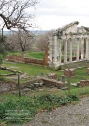
INTEGRATED SURVEYING SYSTEMS FOR BURIED ARCHITECTUREM. PasquiniDipartimento <strong>di</strong> Architettura, Disegno, Storia, Progetto; Facoltà <strong>di</strong> Architettura; Università degli Stu<strong>di</strong> <strong>di</strong> Firenze, ItaliaThe development of the methods and the expected resultsin the field of surveyThe study and practice of architectural mapping now applywell-rooted methods, in continuous evolution, that use themost up-to-date technology for the <strong>di</strong>gital acquisition of metricdata and the consequent graphical projection for numerous<strong>di</strong>fferent purposes.Computer technology has, in fact, revolutionized - from the1980s onwards - the surveying and representation proceduresof constructed spaces, both in terms of measuring the spacesand that of the restitution of the finished product.The changes in procedures and methods have progressedhand-in-hand - cause and effect being strongly correlated -with the expectations and the requests of <strong>di</strong>fferent consumersfrom <strong>di</strong>fferent categories, who are also in a state of flux. Thetechnical surveys that represent architecture in a tra<strong>di</strong>tionalmanner, accor<strong>di</strong>ng to the standards of the descriptive geometryby Monge, have become more and more insufficient inthe overall view of three-<strong>di</strong>mensional representations, whichpermit <strong>di</strong>rect interaction between the consumer and the finalproduct (the development of which was aided, most probablyin a decisive manner, by the <strong>di</strong>ffusion of video-games).The representation of architecture for scientific and popularpurposes has opened new horizons, meeting the necessitiesof a wider, more heterogeneous au<strong>di</strong>ence. In particular, withregards to the preservation and enhancement of Cultural Heritagethe development of surveying and representation technologieshave made it possible to create systems, more andmore up-to-date, for the employment of both technical anddescriptive information and data.The specific case of rupestrian or hypogeum architecture presentsus with, compared to those built sub <strong>di</strong>vo, further questionsabout accessibility; in many cases, in fact, for reasons ofsafety or organization, entire, absolutely invaluable structuresremain neither accessible nor visitable. Even the attempt tosurvey these complexes can sometimes be dangerous. (Fig. 1)Producing documents that are comprehensible, usable and thatcan be shared easily, therefore, is, in this case, absolutely essential,not just for the transmission of knowledge and the historicalmemory of the heritage, but also for the correct managementwhen it comes to preservation and enhancement.A correct measuring systemThe experience gained in past years has underlined how <strong>di</strong>gitalsurveying technology is perfectly suited to this type ofoperation, especially in the study of structures cut in rock,where mapping parameters with classical instruments usuallyrequires extremely long periods of time, with scarce resultsin terms of overall reliability; the lack of alignment and sharpFig. 1 Examples of limited accessibility to rupestrian or underground sites.175volumeRicerca_OK_2012-11-15.indd 175 16/11/2012 15:03:04