habitat rupestre.pdf - Società Friulana di Archeologia
habitat rupestre.pdf - Società Friulana di Archeologia
habitat rupestre.pdf - Società Friulana di Archeologia

Create successful ePaper yourself
Turn your PDF publications into a flip-book with our unique Google optimized e-Paper software.
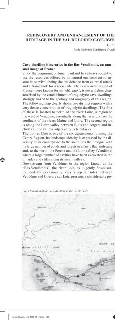
REDISCOVERY AND ENHANCEMENT OF THE INHABITED BUT FRAGILE CAVE-DWELLINGHERITAGE IN THE VAL DE LOIRE: CAVE-DWELLING ITINERARIES IN THE BAS-VENDÖMOISE. CrescenziEcole Nationale Supérieure d’Architecture de Paris La Villette, FranceCave-dwelling itineraries in the Bas-Vendömois, an unusualimage of FranceSince the beginning of time, mankind has always sought touse the resources offered by its natural environment to ensureits survival, being shelter, defence from external attackand a framework for a social life. The centre-west region ofFrance, more known for its “châteaux”, is nevertheless characterisedby the establishment of troglodytic cave-dwellingsstrongly linked to the geology and orography of this region.The following map clearly shows two <strong>di</strong>stinct regions with avery dense concentration of troglodytic dwellings. The firstof these is located to north of the river Loire, a region tothe west of Vendôme, essentially along the river Loir on theconfluent of the rivers Maine and Loire. The second regionis along the Loire valley between Blois and Angers and includesall the valleys adjacent to its tributaries.The Loir et Cher is one of the six departments forming theCentre Region. Its landscape identity is expressed by the <strong>di</strong>versityof its countryside: to the south lies the Sologne withits large number of ponds and forests in a fairly flat landscapeand, to the north, the Perche and the Loir valley (Vendôme)where a large number of cavities have been excavated in thehillsides and cliffs along its small valleys.Downstream from Vendôme, in the region known as the“Bas-Vendômois”, the river Loir, as it gently flows surroundedby occasionally very steep hillsides betweenVendôme and Couture sur Loir, presents a considerable potentialfor sizeable underground cavities. Due to its largenumber of meanders, the landscape is one of villages setback on spurs, such as those to be found in Lavar<strong>di</strong>n, or<strong>di</strong>rectly overhanging the river and built up over terraces asin Trôo. The troglodytic dwellings occupied and continueto occupy a large part of the rural space. Although occasionallyisolated, they are generally grouped into villages,all of which presenting structuring social amenities, suchas the church, the well and the oven. Examples of these canbe found in the hillsides of Trôo, Roches l’Evêque, and StAndré in Villiers sur Loir. The reasons for the establishmentof these troglodytic sites are explained by the geologicalhistory of the area. The Val de Loir forms part of thoseregions that were covered by the “mer de Craie” sea around100 million years ago and, much later by the shallow (-300m) but hot “mer des faluns” which left se<strong>di</strong>mentary rock,being the shelly sand and sandy chalk that can be picked outin the orographic network.There are three types of sandy chalk: chalky marl, whitesandy chalk in the form of regular and homogenous banks(used as a construction material), and yellow sandy chalkin the form of irregular strata with layers of flint. The latteris more porous than the white chalk and can be found inlarge e<strong>di</strong>fices such as the Tours cathedral. Its porosity is theresult of the “washing” action of surface waters penetratingthe soil by infiltration. This phenomenon is particularlyvisible in Trôo, in the petrifying cave we shall subsequentlyFig. 1 Situation of the cave-dwelling in the Val de Loire.141volumeRicerca_OK_2012-11-15.indd 141 16/11/2012 15:02:30