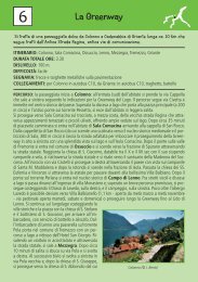
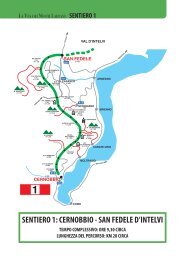
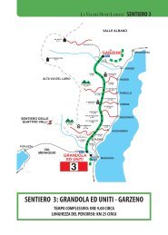
5MONTI DI NAVADa Croce si sale attraversa il bosco <strong>con</strong> scorcisulla Val <strong>Menaggio</strong> ai pascoli dei Monti <strong>di</strong> Navaper poi scendere lungo una bella mulattiera <strong>con</strong>stupenda vista del centro lago e la montagna circostante,a Griante.- punto <strong>di</strong> partenza per la passeggiata: Croce393 m (2km da <strong>Menaggio</strong>)- <strong>Menaggio</strong> - Croce in autobus: linea C12- ritorno: Griante-<strong>Menaggio</strong> in autobus lineaC10 oppure a <strong>pie<strong>di</strong></strong> lungo la statale (40 min)- durata della passeggiata: ore 3.30- <strong>di</strong>slivello: 450 m- segnavia: rosso-bianco-rosso 2 fino ai Monti<strong>di</strong> NavaPercorso: Dalla fermata del bus <strong>di</strong> Croce si prosegueuna decina <strong>di</strong> metri sulla carrozzabile, poi la si attraversaimboccando la strada verso il Golf seguendo lasegnaletica della “Via dei Monti Lariani”. (La Via deiMonti Lariani è un percorso <strong>di</strong> trekking lungo 125 kmche collega i monti sulla sponda ovest del lago. Il nostropercorso segue un piccolo tratto della “Via” fino allaBocchetta <strong>di</strong> Nava). Si passa davanti a un bellissimolavatoio e poco oltre si prende a destra il sentiero chesale alla chiesetta della Madonna <strong>di</strong> Paullo, dal cuisagrato si gode una bella vista sulla Val <strong>Menaggio</strong>.Continuando sulla carrareccia in ripida salita, si attraversala località Mié e, semore seguendo la segnaleticadella Via dei Monti Lariani si arriva ai bei prati deiMonti <strong>di</strong> Nava sovrastati del impressionante mole delMonte Crocione. Il più antico tracciato della StradaRegina, via <strong>di</strong> transito ai valichi Alpini, passava dallaBocchetta <strong>di</strong> Nava per scendere a Griante, strada usataanche per il pellegrinaggio verso Roma. Quasi in pianosi giunge alla Bocchetta <strong>di</strong> Nava e all'altezza dell'ultimacasa (segnavia Griante) si lascia la mulattiera <strong>con</strong> lasegnaletica della “Via dei Monti Lariani 2” e si prendea sinistra per imboccare la mulattiera, che a tornantiscende verso il lago <strong>con</strong> ampia vista sul promontorio <strong>di</strong>Lavedo e i paesi <strong>di</strong> Tremezzo, Mezzegra e Lenno. Piùavanti il sentiero gira verso il versante sopra Griante <strong>con</strong>una bella vista sul Sasso San Martino e l’omonima chiesetta.Si passa la deviazione per la cappella degli alpini,raggiungibile in 10 minuti, e subito dopo si giunge adun altro bivio dove si tiene la sinistra. Si sbuca sulla stradache collega Rogaro <strong>con</strong> Griante e la si segue a sinistraverso Griante. Dopo un centinaio <strong>di</strong> metri si oltrepassauna deviazione per la chiesetta <strong>di</strong> San Martino, si<strong>con</strong>tinue però sempre <strong>di</strong>ritto e poco più avanti si scenderipidamente per sbucare in Via S. Martino. Dopo unadecina <strong>di</strong> metri c’è una se<strong>con</strong>da deviazione per la chiesetta<strong>di</strong> S. Martino, che per chi volesse è raggiungibile,per una comoda mulattiera in ca. 40 min.Lungo il sentiero acciottolato che <strong>con</strong>duce a S. Martinosi susseguono <strong>di</strong>verse cappelle <strong>con</strong> decorazioni amosaico, raffiguranti episo<strong>di</strong> della vita <strong>di</strong> Cristo. Ametà strada si in<strong>con</strong>tra la Cappella degli Alpini, de<strong>di</strong>cataa S. Carlo. La chiesa <strong>di</strong> S. Martino fu costruita nelXVI secolo e <strong>di</strong>venne poi un venerato santuario marianoin seguito al ritrovamento <strong>di</strong> una quattrocentescastatua lignea della Madonna <strong>con</strong> il Bambino. La leggendanarra infatti che nel Seicento la statua fu trovatada una fanciulla del paese in una grotta della montagna,dove era stata messa in salvo cent’anni prima daun abitante <strong>di</strong> <strong>Menaggio</strong>, quando il paese venne devastatodai Grigioni. Portata la notizia in paese, i fedeliaccorsero e trasportarono il simulacro nella parrocchiale<strong>di</strong> SS. Nabore e Felice, ma da qui miracolosamenteesso sparì e venne ritrovato ancora sul Sasso <strong>di</strong>S. Martino. Ciò venne interpretato come il desiderio <strong>di</strong>Maria <strong>di</strong> essere venerata sul posto, per cui sorse primauna nicchia e poi l’attuale costruzione. Ancora oggiessa è meta <strong>di</strong> numerosi fedeli.Passata la deviazione per la Chiesa <strong>di</strong> S. Martino, si <strong>con</strong>tinuain Via S. Martino e dopo una decina <strong>di</strong> metri si puòscegliere <strong>di</strong> seguire a destra la <strong>con</strong>tinuazione <strong>di</strong> Via S.Martino, che entra nel centro storico <strong>di</strong> Griante, chemerita una visita, oppure <strong>di</strong> <strong>con</strong>tinuare in Via al Vignoloche sbuca in Via Belvedere. La si segue a sinistra perarrivare sulla statale proprio davanti alla fermata del bus(dall'altra parte della strada). Tragitto a <strong>pie<strong>di</strong></strong> a<strong>Menaggio</strong> ca. 40 min.
MONTI DI NAVA 5This itinerary leads from Croce through thewoods up to the pasture fields of Monti <strong>di</strong> Navaand then descends to Griante with a marvelousview of the center lake area and the surroun<strong>di</strong>ngmountains.- starting point: Croce 393 m (2 km from<strong>Menaggio</strong>)- <strong>Menaggio</strong> – Croce by bus: line C12- return: Griante – <strong>Menaggio</strong> by bus line C10or by foot 3 km- total walking time: 3.30 hrs- ascent: 450 m.- trail signs: red/white/red 2 as far asBocchetta <strong>di</strong> Nava.Route: From the bus stop at Croce in front of HotelAdler, <strong>con</strong>tinue for about 30 m on the main road andthen cross it. Pick up the road in the <strong>di</strong>rection of thegolf course in<strong>di</strong>cated with the trail signs of the “Viadei Monti Lariani” trail n° 2. The Via dei MontiLariani is a trekking route of 125 km that <strong>con</strong>nects the“Monti” on the west side of the lake. This walk followsa small part of this marvelous route as far asBocchetta <strong>di</strong> Nava. You pass a typical washhouse onyour right and slightly further you pick up the path onthe right that leads up to the church of the Madonna <strong>di</strong>Paullo. From the churchyard you have a nice view ofthe <strong>Menaggio</strong> valley. From here you follow the steepcart track that with the signs of the “Via dei MontiLariani” ascends through the woods to the area Miéand from there to the beautiful pastures of “Monti <strong>di</strong>Nava” at the foot of Monte Crocione. An even trackleads to “Bocchetta <strong>di</strong> Nava” and near the last buil<strong>di</strong>ng(sign Griante) you leave the “Via dei Monti Lariani”(path 2 <strong>con</strong>tinues as far as San Fedele d’Intelvi) andyou pick up the trail to the left. The old roman road“L’antica Strada Regina”, one of the main <strong>con</strong>nectionroads with the alpine passes, used to lead overBocchetta <strong>di</strong> Nava down to Griante. The track leadsdown in wide bends with a most beautiful view of thepeninsula of Lavedo, and the towns of Tremezzo,Mezzegra and Lenno. The trail then turns to the slopeabove Griante with a splen<strong>di</strong>d view of Sasso SanMartino and its little church. You pass the deviation forthe “Cappella degli Alpini” (reachable in 10 minutes)and shortly after you arrive at a fork where you keepleft. The track ends up on a road that <strong>con</strong>nects Rogarowith Griante; turn left in the <strong>di</strong>rection of Griante andafter a few hundred meters you will pass a deviationlea<strong>di</strong>ng to the church S. Martino on the left. You <strong>con</strong>tinuestraight on though, in Via Cruziada that after awhile descends steeply and eventually ends in Via S.Martino. Slightly ahead on the left there is a se<strong>con</strong>ddeviation for the church S. Martino which, if youwish, can be reached from here in about in 40 min.Along the path to San Martino there are a series of littlechapels decorated with mosaics representingvarious stages of Christ’s life. About half way youencounter the chapel Cappella degli Alpini, de<strong>di</strong>catedto S. Carlo. The S. Martino church was built in the XVIcentury to house the wooden statue of the 14th centuryrepresenting the Madonna with Child. The legendtells that the statue was found in the 16th century by ashepherd girl in a cave in the mountains where it wasput a century before by an inhabitant of <strong>Menaggio</strong>when the town was destroyed by the Grigioni. The statuewas brought down to the parish church where itmiraculously <strong>di</strong>sappeared and was found again on theSasso <strong>di</strong> S. Martino. This was interpreted as the desireof Maria to be venerated on the mountain. First asmall shrine was built and then the church.Past the deviation for the church you <strong>con</strong>tinue in ViaS. Martino and after 30 meters you can choose to followthe <strong>con</strong>tinuation of Via S. Martino to the right thatleads into the historical center of Griante, that is wortha visit, or you can <strong>con</strong>tinue in Via Vignolo that ends inVia Belvedere. Follow it to the left in order to arriveon the main lake side, right in front of the bus stop (byfoot to <strong>Menaggio</strong> 40 minutes).