Itinerari consigliati a piedi nei dintorni di Menaggio con piantina
Itinerari consigliati a piedi nei dintorni di Menaggio con piantina
Itinerari consigliati a piedi nei dintorni di Menaggio con piantina
- No tags were found...

You also want an ePaper? Increase the reach of your titles
YUMPU automatically turns print PDFs into web optimized ePapers that Google loves.
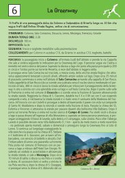
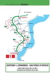
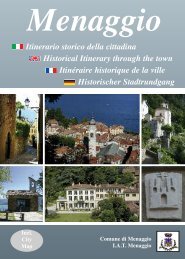
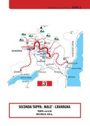
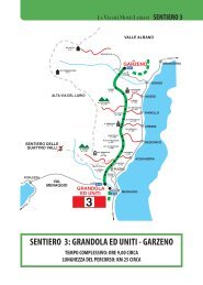
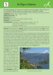
Passeggiate<strong>nei</strong> <strong><strong>di</strong>ntorni</strong> <strong>di</strong> <strong>Menaggio</strong>Si è tentato <strong>di</strong> fare una scelta valida tra i tanti itinerari possibili nella zona intorno a <strong>Menaggio</strong> e<strong>di</strong> proporre dei percorsi <strong>di</strong> <strong>di</strong>versa lunghezza e <strong>di</strong>fficoltà. Ogni percorso è preceduto da una piccolanota introduttiva e <strong>di</strong> seguito le in<strong>di</strong>cazioni tecniche: punto <strong>di</strong> partenza, durata della passeggiata,<strong>di</strong>slivello, segnavia e infine la descrizione dell’itinerario. Nel libretto troverete oltre a una<strong>piantina</strong> <strong>di</strong> <strong>Menaggio</strong>, una piccola cartina che illustra i percorsi che sono numerati e segnati ciascuno<strong>con</strong> un colore <strong>di</strong>verso. Si <strong>con</strong>siglia comunque la seguente cartografia: la cartina “Kompass91, Lago <strong>di</strong> Como/Lago <strong>di</strong> Lugano scala 1:50.000” reperibile in cartoleria o in e<strong>di</strong>cola, oppure la“Carta Topografica Escursionistica” della Comunità Montana Alpi Lepontine scala 1:25.000.Per gli spostamenti <strong>con</strong> l'autobus si ricorda che i biglietti vanno acquistati a terra.Si fa presente che, oltre al libretto “Lago <strong>di</strong> Como Trekking” che descrive i percorsi <strong>di</strong> trekking“La Via dei Monti Lariani”, “Il Sentiero delle 4 Valli” e “La Dorsale del Triangolo Lariano”, sono<strong>di</strong>sponibili delle schede <strong>con</strong> altre passeggiate nella Provincia <strong>di</strong> Como reperibili presso l'UfficioI.A.T. <strong>di</strong> <strong>Menaggio</strong>. Buona Passeggiata!Walksin the surroun<strong>di</strong>ngs of <strong>Menaggio</strong>It is not easy to choose from the many walks that the area around <strong>Menaggio</strong> offers; belowyou will find eight of various length and <strong>di</strong>fficulty. They all start with a small introduction,then follows the detailed information: starting point, time, ascent, trail signs and the routedescription. In this booklet there is a small map showing the itineraries which here are numberedand each in<strong>di</strong>cated with a <strong>di</strong>fferent color and a map of <strong>Menaggio</strong>.More detailed topographical maps like the Kompass map 91 Lago <strong>di</strong> Como/Lago <strong>di</strong>Lugano scale 1:50.000 and the map “Carta Topografica Escursionistica” della ComunitàMontana Alpi Lepontine scale 1:25.000 are available at the bookstores. We remind you thatif you go the trailhead by bus, tickets must be bought before boar<strong>di</strong>ng.Apart from this brochure the tourist office provides information about the major trekkingroutes around lake Como like “The Via dei Monti Lariani”, a 6 day hike, “Il Sentiero delle4 Valli”, a 3 day hike and “La Dorsale del Triangolo Lariano”, a 2 day hike; they are collecte<strong>di</strong>n a brochure called “Lake Como Trekking”. The leaflet “On Foot in the Province ofComo” <strong>con</strong>tains 22 mostly easy walks in the Province of Como. Enjoy your walks!