You also want an ePaper? Increase the reach of your titles
YUMPU automatically turns print PDFs into web optimized ePapers that Google loves.
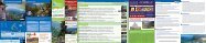
01 Percorso di Torcegno<br />
04 Percorso Ponte del Salton<br />
07 Percorso Le Parti<br />
10 Percorso dell’Arboreto<br />
13 3 T BIKE Percorso dei Castagni<br />
WWW.VALSUGANA.INFO<br />
IT<br />
GB<br />
Lasciato l’abitato di Torcegno il percorso si snoda nella immediata periferia, tra dolci<br />
salite all’ombra di castagni secolari nella parte iniziale e tra strette stradine di campagna<br />
nella parte terminale dello sterrato. Le suggestioni sulle montagne circostanti e sullo<br />
stesso Torcegno rendono l’anello di grande impatto paesaggistico. Per chi lo desidera,<br />
dopo metà strada, è possibile abbreviare il percorso in modo autonomo prendendo delle<br />
strade secondarie asfaltate che conducono al campo sportivo, punto di partenza. In tutto<br />
4,9 km che si sviluppano in parte su fondo sterrato regolare in parte su strada asfaltata<br />
di tipo urbano.<br />
Leaving the village of Torcegno the track leads to the outskirts, at the beginning among<br />
gentle uphill paths in the shade of ancient chestnut trees and in narrow country lanes<br />
at the end of the track. This circular walk has a great landscape impact thanks to the<br />
surrounding mountains and Torcegno. If you wish, after half way, you can shorten the<br />
path taking paved paths that lead to the sports field, the starting point. 4.9 km of overall<br />
length developed on dirt paths and on asphalt road.<br />
IT<br />
GB<br />
Dal Ponte del Salton (1067 mt), in Val Calamento, si arriva sull’altopiano di Musiera<br />
(1400 mt). È questo il percorso più lungo e impegnativo del Nordic Walking Park Lagorai:<br />
oltre 11 km, 5.6 all’andata + 5.6 al ritorno lungo la stessa strada forestale, che permettono<br />
di apprezzare le due principali aree turistiche del Comune di Telve. Il tracciato si sviluppa<br />
intermante su sfondo sterrato regolare all’interno di un maestoso bosco di abete rosso.<br />
Alla conclusione del percorso, per arrivare sull’altopiano di Musiera e godere dei suoi<br />
suggestivi panorami, è necessario proseguire per circa 1 km lungo la strada principale.<br />
From Ponte del Salton (1067 mt), in Val Calamento, you can reach Musiera (1400 mt). This<br />
is the longest and demanding track of Nordic Walking Park Lagorai: over 11 km, 5.6 to go +<br />
5.6 to come back from the same road, which allow you to appreciate the two main tourist<br />
areas of Telve. The track is entirely on dirt road in a majestic spruce pine forest. At the end<br />
of the path, to reach Musiera and enjoy its beautiful landscapes, is necessary to go on for<br />
about 1 km along the main road.<br />
IT<br />
GB<br />
Un campo scuola nella zona sportiva di Castello Tesino. Il tracciato è ideale per muovere<br />
i primi passi accompagnati da un istruttore o affinare la tecnica in tutta tranquillità.<br />
Il percorso, di facile e breve percorrenza, interamente pianeggiante, si articola in parte<br />
su fondo sterrato regolare in parte su strada asfaltata, con partenza e arrivo dal Pub<br />
Canterbury. Situato a pochi minuti dal centro abitato permette una piacevole e rilassante<br />
passeggiata anche ai meno allenati, godendo di una splendida veduta dell’abitato di<br />
Castello Tesino.<br />
A school camp in the sporting zone of Castello Tesino. The walk is ideal to have the first<br />
experience accompanied by an istructor or improve your technique. The easy, short and<br />
flat itinerary winds along dirt road and partly on asphalt road, starting and arrival point<br />
pub Canterbury. Only few minutes from the town center this relaxing track is also suitable<br />
to beginners from the path you can enjoy the panoramic view of Castello Tesino.<br />
IT<br />
GB<br />
Il tracciato si sviluppa lungo un sentiero didattico a carattere botanico ottimamente<br />
curato. Lungo il breve e facile percorso sarà possibile attraversare differenti ambienti e<br />
imparare a riconoscere, in modo del tutto autonomo, le loro caratteristiche principali e le<br />
differenti specie vegetali che caratterizzano l’altopiano del Tesino. Il tracciato, strutturato<br />
ad anello, si articola, per 1,9 km su sfondo sterrato regolare. Significativi e degni di nota<br />
sono l’attraversamento di una torbiera naturale e la sosta presso il Giardino d’Europa,<br />
inaugurato nel 2011.<br />
The track runs along an educational trail with botanical character. Along the short and<br />
easy path is possible to go trough different environments and learn to recognize their<br />
main characteristics and different plant species that characterize the plateau Tesino.<br />
The circular track is for 1.9 km on dirt road. Significant and noteworthy are the crossing of<br />
a natural peat-bog and the Garden of Europe, opened in 2011.<br />
IT<br />
GB<br />
Partendo dal centro di Torcegno ci si immerge fin da subito nel verde dei campi che<br />
conducono alla chiesetta della Madonna Ausiliatrice. Un antico selciato conduce poi<br />
verso la sommità del Colle di San Pietro (conosciuto anche come Monte Cioplina), un<br />
punto strategico che domina il territorio della <strong>Valsugana</strong> orientale. Stupendi capitelli in<br />
legno della Via Crucis fanno compagnia lungo la discesa verso l’abitato di Telve di Sopra.<br />
A monte dello stesso ci si dirige verso la Loc. Parise, per iniziare la suggestiva salita tra<br />
le coltivazioni di castagni secolari. Questo paesaggio unico accompagna gli escursionisti<br />
fino alla frazione di Campestrini; a questo punto basta percorrere solo un piccolo tratto<br />
prima di ritornare al punto di partenza.<br />
Starting from the town center of Torcegno you will be in the middle of green fields that<br />
surround the country road which leads to the church of Madonna Ausiliatrice. The ancient<br />
track leads to the top of the hill of San Pietro (also known as Mt Cioplina), a strategic look<br />
out on the eastern territory of <strong>Valsugana</strong>. Beautiful capitals made of wood follow you on<br />
the way down to the village of Telve di Sopra, from here you head towards Loc. Parise<br />
where starts the uphill among the chestnut trees. This unique landscape takes hikers to<br />
the sourranding of Campestrini; at this point you just need to go on along a little stretch<br />
before arriving to the starting point.<br />
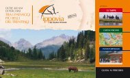
Lagorai<br />
Nordic Walking Park<br />
Camminare nella natura<br />
E TU<br />
DI CHE<br />
VACANZA<br />
SEI<br />
WHAT TYPE<br />
OF HOLIDAY<br />
SUITS<br />
YOU BEST<br />
Scopri altri tipi di vacanza in <strong>Valsugana</strong>:<br />
Find out other types of holiday in <strong>Valsugana</strong>:<br />
Famiglie<br />
Family<br />
Turismo accessibile<br />
Accessible tourism<br />
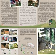
Foto:<br />
Fototeca Trentino Marketing S.p.A.<br />
foto di Ronny Kiaulehn - Daniele Lira<br />
Walter Turcato<br />
Bike<br />
Bike<br />
VALSUGANA<br />
Azienda per il Turismo<br />
Viale V. Emanuele, 3 - 38056 Levico Terme (TN)<br />
Tel. +39 0461 727700 - Fax +39 0461 727799<br />
info@valsugana.info<br />
Terme&Benessere<br />
Thermal Spa&Wellness<br />
OFFICIAL SPONSOR:<br />
Campings<br />
Camping<br />
Turismo Rurale<br />
Rural tourism<br />
Inverno<br />
Winter<br />
IT<br />
GB<br />
02<br />
Percorso Naturalistico G. Caccia Franco Furlan<br />
Nature Trail Franco Furlan<br />
Un percorso dentro il percorso, questo è il sentiero naturalistico Franco Furlan. Adatto<br />
a chi vuole praticare Nordic Walking in tutta tranquillità e nel contempo conoscere le<br />
risorse ambientali che caratterizzano il territorio. Immersi dall’inizio alla fine in un bosco<br />
a prevalenza di abete rosso, lungo quasi 2 km del facile anello si possono incontrare<br />
numerose tabelle informative in materia di flora, fauna e gestione forestale. Le tante aree<br />
di sosta presenti lungo il tracciato permettono un piacevole pic-nic all’aria aperta o momenti<br />
di svago per i più piccoli. Il percorso si sviluppa interamente su sfondo sterrato regolare.<br />
Suitable for anyone who wants to practice Nordic Walking and at the same time learn<br />
something about the environmental resources that characterize the area. Immersed from<br />
the beginning to the end in a spruce pine wood, almost 2 km long. Along this circular track<br />
you can easily find numerous signs on flora, fauna and forest management. There are<br />
many areas which allow to have a pic nic and outdoor leisure time for children. The track is<br />
entirely on dirt paths.<br />
IT<br />
GB<br />
05<br />
Percorso dell’acqua<br />
Un percorso ad anello di media difficoltà che permette di apprezzare le varietà di<br />
paesaggi dell’incantata Val Campelle. Per lunghi tratti si costeggia il torrente Maso, per<br />
poi incamminarsi verso l’Agritur malga Casarina dove è possibile una piacevole sosta<br />
gastronomica o una osservazione della lavorazione del latte. Nella parte conclusiva,<br />
avvolti da boschi di abete rosso, è possibile ammirare un’affascinate panorama sulla valle<br />
aperta e sulle cime più alte. Il tracciato si sviluppa in prevalenza su strada sterrata con<br />
fondo regolare e solo a tratti su strada asfaltata.<br />
A circular track of moderate difficulty that allows you to appreciate the variety of<br />
landscapes of Val Campelle. For long stretches the walk follows the stream Maso then<br />
goes on towards the Agritur Malga Casarina where you can taste typical products or<br />
experience the milk processing. In the end, surrounded by forests of spruce pine, you<br />
can admire a fascinating landscape of the open valley and the highest peaks. The trail is<br />
mostly on dirt roads and only occasionally on an paved road.<br />
IT<br />
GB<br />
08 Percorso di Celado<br />
11 Percorso Pian di Mela<br />
Il percorso si contraddistingue per la sua bellezza e unicità paesaggistica. Si attraversa<br />
infatti buona parte del Celado, altopiano caratteristico e suggestivo per via degli ampi<br />
prati fioriti e dei dolci pendii che offrono vedute mozzafiato e allo stesso tempo rilassanti.<br />
La partenza del tracciato è situata presso il ristorante “Ai Larici”, l’ arrivo presso il ristorante<br />
“Al Cacciatore”. I locali presenti lungo il percorso offrono la possibilità di una piacevole<br />
sosta gastronomica con prodotti tipici.<br />
The path is characterized for its beauty and unique landscape. It runs through Celado<br />
plateau characteristic and suggestive because of the large meadows and rolling hills that<br />
offer breathtaking and relaxing view. Starting point by restaurant “Ai Larici”, arrival point<br />
by restaurant “Al Cacciatore”. On the way there are few restaurants where stop and taste<br />
local products. 5 km (2.5 km + 2.5 km) of overall length that runs entirely on dirt road<br />
along the same track.<br />
IT<br />
GB<br />
A ridosso dell’abitato di Cinte Tesino, questo percorso ad anello, permette una piacevole<br />
e semplice uscita senza allontanarsi troppo dal cuore del paese. Lungo i 4,4 km che<br />
costituiscono il tracciato si attraversano tratti di bosco e spazi più aperti caratterizzati da<br />
campi, vecchi masi e scorci paesaggistici sul gruppo di Cima d’Asta e l’abitato di Castello<br />
Tesino. Il percorso si sviluppa in parte su strada asfaltata e in parte su fondo sterrato regolare.<br />
Close to the town of Cinte Tesino, this circular track is a nice and simple walk not far away<br />
from the town centre. The track, 4.4 km long, takes you through forest and open spaces<br />
characterized by fields, old farmhouses and landscapes on the group of Cima d’Asta and the<br />
village of Castle Tesino. The route is partly on paved road and partly on dirt roads.<br />
IT<br />
GB<br />
14<br />
3 T BIKE Percorso Parco Fluviale<br />
e Piccoli Frutti<br />
Partendo dal centro di Telve ci si dirige verso il fondovalle in direzione di Castelnuovo,<br />
ammirando lunghi vigneti e colture di piccoli frutti, le coltivazioni pregiate alle quali è<br />
particolarmente vocato questo territorio. Un breve tratto pianeggiante permette di<br />
raggiungere il bellissimo Parco fluviale di Carzano, che con i suoi prati, il laghetto e le<br />
passeggiate in riva al torrente Maso, è una meta pregiata per trascorrere ore tranquille<br />
con la propria famiglia. Si risale poi verso il paese di Carzano e, lungo la strada che conduce<br />
a nord, prima si incrocia l’antica Via Claudia Augusta e poi si ritorna in un batter d’occhio al<br />
centro dell’abitato di Telve.<br />
Starting from the town centre of Telve go towards the valley bottom in direction of<br />
Castelnuovo. This walking track allows you to admire long vineyards and crops of small<br />
fruits, crops which are particularly suited for this territory. Trough a short flat path you<br />
reach the beautiful Carzano River Park. With its meadows, the pond and the walking<br />
tracks along the river Maso, this is a prized destination for spending quiet hours with your<br />
family. Then you will reach Carzano village and, along the road that leads north, you will<br />
cross the ancient Via Claudia Augusta and then in a few minutes you will be in the town<br />
center of Telve.<br />
€ 2,00<br />
- best in the alps!<br />
Corsi di gruppo, lezioni individuali ed uscite di Nordic Walking<br />
Group courses, individual lessons and Nordic Walking trips<br />
Via De Le Parti 8/A - 38053 - Castello Tesino (TN)<br />
Cell.+39 347 8462891 - Cell. +39 345 2934692<br />
www.asd-sportivamentetesino.blogspot.it<br />
asd.sportivamentetesino@gmail.com<br />
GB<br />
ASD Sportiva-mente Tesino<br />
03<br />
Percorso di Musiera<br />
06<br />
Percorso di Conseria - Val Campelle<br />
09 Percorso di Spiado<br />
12 Percorso Col dei Duri<br />
15<br />
3 T BIKE Percorso Storia e Leggenda<br />
History and Legend<br />
GB<br />
IT<br />
GB<br />
Un percorso pensato per collegare due strutture ricettive e godere di momenti rilassanti<br />
sull’altopiano di Musiera, piccola “perla verde” che permette di ammirare il Lagorai da una<br />
prospettiva diversa dal solito. La partenza è presso l’albergo-ristorante “La Ruscoletta”,<br />
a Musiera bassa, l’arrivo presso il ristorante “Laghetto”, a Musiera alta, dove è possibile<br />
praticare anche la pesca sportiva dopo una piacevole sosta gastronomica. Una semplice<br />
e corta camminata in parte su strada asfaltata che, solo nella parte terminale, attraversa<br />
per un breve tratto un sentiero in mezzo al bosco su fondo sterrato non regolare. Il<br />
ritorno è sul medesimo tracciato, sebbene siano possibili alcune scorciatoie non segnate.<br />
A trail designed to connect two facilities and enjoy relaxing moments on Musiera,<br />
that allows you to admire the Lagorai chain from a different perspective than usual.<br />
Starting point by hotel-restaurant “La Ruscoletta” in Musiera bassa, ending point by<br />
restaurant “Laghetto”, Musiera alta, where you can go sport fishing after trying our<br />
local products. A nice and short walk on paved road, only at the end the track goes<br />
through the woods on dirt path. The return is on the same track, although there may<br />
be some unmarked shortcuts.<br />
IT<br />
GB<br />
Dal Ponte Conseria al bivacco Nàssare: un’andata e ritorno di media difficoltà lungo<br />
la medesima strada forestale. Il tracciato permette di conoscere i paesaggi che<br />
caratterizzano il limite della vegetazione arborea. Dai boschi di abete rosso frammisti a<br />
larice della partenza si giunge, in prossimità del bivacco, a pascoli aperti punteggiati da<br />
affascinati esemplari di pino cembro (in dialetto “zirmo”), essenza forestale propria delle<br />
quote alto-montane. Il percorso si sviluppa interamente su fondo sterrato regolare. In<br />
modo autonomo, continuando lungo il medesimo sentiero, si può arrivare, dopo 1.8 km al<br />
ponte Caldenave, luogo di rara bellezza paesaggistica.<br />
From the bridge Conseria to the bivouac Nàssare: a return of moderate difficulty along<br />
the same forest road. The path allows you to know the landscapes that characterize the<br />
treelined. After walking through spruce pines and beech forest you will reach the bivouac<br />
which lies in open grasslands with facinating Cembro pines (in dialect called “zirmo”). The<br />
route is entirely on dirt road. By yourself, going on along the same tracks, you can get,<br />
after 1,8 km to the bridge Caldenave, a place of rare beauty.<br />
IT<br />
GB<br />
Quasi 7 km per un lungo tracciato ad anello che permette di conoscere più da vicino il<br />
vasto territorio di Pieve Tesino. Il percorso è adatto a chi è già mediamente allenato e ha<br />
voglia di passare un’intera mezza giornata a stretto contatto con la natura. Si attraversano<br />
formazioni forestali perlopiù di abete rosso e in parte a faggio. Il bosco, per lunghi tratti<br />
fitto, in più occasioni si apre regalando, come d’improvviso, preziosi scorci paesaggistici<br />
sulla <strong>Valsugana</strong>. Il tracciato si snoda in gran parte lungo una strada forestale. Nella sua<br />
parte iniziale è interamente su sfondo sterrato regolare, nella sua parte conclusiva su<br />
strada asfaltata.<br />
Nearly 7 km for a circular track which allows you to get closer to the territory of Pieve<br />
Tesino. The path is suitable for trained people or for those who would like to spend half<br />
day immersed in nature. It is mostly through spurce pines and beech tree forests. The<br />
thick wood, suddenly offer the opportunity to see precious landscapes of <strong>Valsugana</strong>. The<br />
track runs mostly along a forest road. The first part is entirely on dirt roads, in the end on<br />
paved road.<br />
IT<br />
GB<br />
Questo percorso ad anello, adatto a chi è provvisto di un minimo di allenamento, permette<br />
di praticare il Nordic Walking in uno scenario di indiscutibile bellezza quale quello di Monte<br />
Mezza. Il tracciato ripercorre una strada forestale ancora in uso e si sviluppa interamente<br />
su fondo sterrato regolare. Le suggestioni paesaggistiche sono fornite dagli estesi boschi<br />
di faggio presenti e dagli scorci sull’Altopiano del Tesino e l’abitato di Castello. Degno di<br />
una sosta è lo spettacolare punto panoramico sulla <strong>Valsugana</strong> con pareti a strapiombo,<br />
che si incontra non molto dopo la partenza.<br />
This circular track, suitable for those who provided a minimum of training, allows to<br />
practice the Nordic Walking in a beautiful setting such as Monte Mezza. The route goes<br />
through a forest road still in use and developed entirely on dirt road. The beech trees<br />
forest and views on Tesino plateau and Castello Tesino town are the subject of the<br />
beautiful landscapes of this area. Worth a visit the spectacular panoramic spot on<br />
<strong>Valsugana</strong> with sheer cliffs, which can be observed not long after departure.<br />
IT<br />
GB<br />
Partendo da Piazza Maggiore nell’abitato di Telve si percorre la strada panoramica che<br />
porta ai Masi di Carzano (i masi Caverna) e si imbocca la salita di Sant’Antonio affrontando<br />
una pendenza del 15% fino ad incrociare la SP 31 del Passo Manghen. Una breve discesa<br />
è il preludio alla salita per Maso Tezza, dal quale si imbocca la strada forestale di Restena<br />
immersi in un ricco bosco di conifere e latifoglie. Giunti al punto più alto dell’intero<br />
percorso (Loc. Frisanco, 950 m s.l.m.) inizia una vertiginosa discesa che conduce in un<br />
borgo medioevale adiacente a Castellalto, maniero risalente al XIII secolo. Il ritorno a Telve<br />
avviene lungo una suggestiva mulattiera, e solo dopo aver toccato con mano la curiosa<br />
leggenda del “secio e la secia”.<br />
Starting from Piazza Maggiore in the town of Telve walk along the scenic road that<br />
leads to Masi di Carzano (also called Masi Caverna) and take the ascent of St. Antonio<br />
with a gradient of 15% until you reach the SP 31 of Passo Manghen. After a short walk<br />
downhill the track goes uphill reaching Maso Tezza, from where starts the forest road<br />
Restena immersed in a rich forest of conifers and broad-leaved woods. Having reached<br />
the highest point of the path (Loc Frisanco, 950 m) begins a steep descent that leads<br />
into a medieval village close to Castellalto, a manor house dates back to the thirteenth<br />
century. The way back to Telve is along a mule track, after having experienced first hand<br />
the curious legend of the “secio and secia”.<br />
IT Presentazione: 15 percorsi per un totale di 80 km. Il<br />
Nordic Walking Park Lagorai, realizzato con il supporto<br />
di 6 amministrazioni comunali e la collaborazione della<br />
Scuola Italiana Nordic Walking, vuole stimolare la scoperta<br />
paesaggistica in modo attivo ma non invasivo per l’ambiente,<br />
mettendo in risalto preziosi angoli di natura che caratterizzano<br />
il variegato territorio del Lagorai, autentica perla da scoprire.<br />
I tracciati selezionati, differenti tra loro per caratteristiche<br />
tecniche e lunghezza, offrono la possibilità a tutti di avvicinarsi,<br />
perfezionare o praticare questa attività sportiva in assoluta<br />
tranquillità, da soli o in compagnia di un istruttore.<br />
Buona camminata! A passo di Nordic!<br />
3<br />
Camping Valmalene: un tuffo nella natura / A dive into nature<br />
Istruttore di nordic walking in loco abilitato anche per winter nordic<br />
e riabilitazione oncologica.<br />
Nordic walking instructor on site available for winter Nordic<br />
and oncology rehabilitation.<br />
38050 Pieve Tesino (TN) - Tel. +39 0461 594214<br />
www.valmalene.com - info@valmalene.com<br />
IT<br />
GB<br />
4<br />
IT<br />
2<br />
instructors, offers group courses and individual lessons. Special Nordic<br />
Walking tours naturalistic and meditative. Special activities with children.<br />
Cell. +39 392 5598258 - Cell. +39 333 3213449<br />
www.ambios.it – info@ambios.it<br />
In tutto il territorio della <strong>Valsugana</strong> e Tesino, con i suoi istruttori certificati,<br />
offre corsi di gruppo e lezioni individuali. Speciali uscite di Nordic Walking a<br />
carattere naturalistico e meditativo. Speciali attività con bambini.<br />
In the whole territory of <strong>Valsugana</strong> and Tesino, with its certified<br />
AmBios - Per una comunicazione dell’ambiente<br />
For a communication environment<br />
1<br />
IT<br />
Per contattare gli istruttori di zona - To contact the instructors of the area:<br />
Presentation: 15 tracks, 80 km of overall length. The Nordic<br />
Walking Park Lagorai, with the support of 6 municipalities and<br />
the collaboration of the Italian School Nordic Walking, allow<br />
you to discover the territory without damage the environment,<br />
highlighting the nature that characterize Lagorai territory, a<br />
place to be discovered. All the selected walking tracks have<br />
different characteristic in their technique and length, they<br />
offer everyone the chance to get closer this sport or practise it,<br />
alone or with instructors. Good walk!<br />
GB<br />
Rifugio Carlettini<br />
IT Il rifugio Carlettini, immerso nel verde e nella tranquillità della Val<br />
Campelle, è punto ideale per avventurarsi in passeggiate ed escursioni di<br />
tutte le difficoltà. Punto di ristoro con piatti della tradizione locale, offre anche<br />
la possibilità di noleggio bastoncini per il nordic walking.<br />
The refuge Carlettini, immersed in the greenery and peacefulness of<br />
the Val Campelle, it’s the perfect starting point for walking and hiking of<br />
all difficulties. It offers a restaurant with traditional local dishes and the<br />
opportunity to hire Nordic Walking poles.<br />
Località Val Campelle - 38050 Scurelle (TN) - Cell. +39 345 9724899<br />
www.rifugiocarlettini.it - info@rifugiocarlettini.it<br />
GB
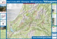
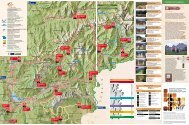
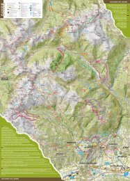
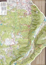
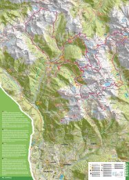
SIMBOLI / PICTOGRAMS<br />
Alloggi / Accomodation<br />
Ristori / Refreshment<br />
Malga / Alpine hut<br />
Bivacco / Bivouac<br />
Ufficio informazioni / Information<br />
Info stagionale / Seasonal Information<br />
Parcheggio / Parking<br />
Punto panoramico / Viewpoint<br />
Cimitero / Cemetery<br />
Chiesa / Church<br />
Stazione treni / Railway Station<br />
Scala / Scale: 1:70.000<br />
Legenda / Legend:<br />
viabilità / road network<br />
Confine regione / Border region<br />
Sentieri segnati SAT / Marked Paths SAT<br />
Ciclabile della <strong>Valsugana</strong> / Cycling Path <strong>Valsugana</strong><br />
Partenza percorsi / Starting point<br />
Superstrada / Highway<br />
Strada importante / Main roads<br />
Strade secondarie / Minor road<br />
Stradine e strade forestali / Roads and forest roads<br />
Ferrovia / Railroad<br />
ISTRUTTORI DI ZONA / instructors of the area:<br />
1 AMBIOS<br />
CAMPING VALMALENE - Pieve Tesino<br />
2<br />
ASD SPORTIVA-MENTE - Castello Tesino<br />
3<br />
4<br />
RIFUGIO CARLETTINI - Scurelle<br />
grado di difficoltà / difficulty<br />
Premesso che nella pratica del Nordic Walking non esistono<br />
percorsi difficili nel presente parco è stata adottata la seguente<br />
catalogazione:<br />
Given that in the Nordic Walking there aren’t difficult trails, in<br />
this park was adopted the following classification:<br />
Percorso NW Facile / Easy<br />
Percorso lungo da 0 a 3 km con dislivello in salita<br />
pressoché nullo o inferiore ai 200 m.<br />
Path from 0 to 3 km long, with almost no height<br />
difference or less than 200 m.<br />
Percorso NW Medio / Medium<br />
Percorso lungo da 3 a 5 km con dislivello in salita<br />
inferiore ai 300 m.<br />
Path from 3 to 5 km long with height difference less<br />
than 300 m.<br />
Percorso NW Difficile / Difficult<br />
Percorso lungo dai 5 ai 12 km con dislivello in salita<br />
compreso tra i 200 e i 500 m.<br />
Path from 5 to 12 km long with height difference<br />
between 200 and 500 m.<br />
4<br />
Cos’ è il Nordic Walking.<br />
What is<br />
nordic walking<br />
IT Il Nordic Walking è una camminata con appositi bastoncini. Può essere a ragione<br />
considerato una delle attività sportive più complete in assoluto. Si pratica all’aria aperta, fa<br />
bene al cuore e alla circolazione, rafforza braccia e spalle, migliora la postura della schiena e<br />
tonifica glutei e addominali.<br />
Facile e alla portata di tutti. Sport per tutti e per tutto l’anno che offre un modo facile,<br />
poco costoso e divertente per gustare uno stile di vita sano e attivo. Per praticarlo bastano un<br />
abbigliamento sportivo e due bastoncini, appositamente studiati, per ottenere il massimo dei<br />
benefici.<br />
I benefici. Con una corretta tecnica si possono ottenere enormi benefici:<br />
> fa perdere peso, si stima che faccia bruciare circa il 45% in più di una normale camminata<br />
> è un movimento veramente completo, si muove fino al 90% della nostra muscolatura<br />
> grazie all’uso dei bastoncini si riducono le sollecitazioni sulle articolazioni<br />
> è un ottimo allenamento cardiocircolatorio e riduce i fattori di stress e depressione<br />
> migliora la capacità aerobica.<br />
Imparare il Nordic Walking Per apprendere il Nordic Walking potete rivolgervi agli istruttori<br />
che sono garanzia di professionalità e competenza. I bastoncini verranno prestati con le lezioni!<br />
GB Nordic Walking is a walking performed with specially designed walking poles. It can be<br />
considered one of the most comprehensive sport. Practiced outdoors is good for the heart and<br />
circulation, strengthen arms and shoulders, improves posture and tones buttocks and abdomen.<br />
Easy to do for everyone. Sport for everyone to practice all the year around. It offers an easy,<br />
inexpensive and funny way to enjoy a healthy and active lifestyle. You need only sportswear<br />
and two poles specially designed to obtain maximum benefits.<br />
Benefits. With proper technique you can get good benefits:<br />
> lose weight, you can burn 45% calories more than a normal walk<br />
> move up to 90% of our muscles<br />
> thanks to the use of the poles it will reduce the stress on the joints<br />
> it is a great cardiovascular workout and it reduces stress factors and depression<br />
> it improves aerobic capacity<br />
Learn the Nordic Walking To learn the Nordic Walking please contact the instructors of<br />
Italian School Nordic Walking, which are a guarantee of professionalism and competence. The<br />
poles will be provided with the lessons!<br />
3<br />
2<br />
WWW.VALSUGANA.INFO<br />
1<br />
map<br />
Realizzazione cartografica: Pradel Marcello<br />
Loc.Stiozze, 38054 TRANSACQUA (TN)<br />
Tel. +39 333 1365227 - pradelm@gmail.com