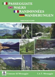
Passeggiate in Tremezzina - Comune di Menaggio
Passeggiate in Tremezzina - Comune di Menaggio
Passeggiate in Tremezzina - Comune di Menaggio

Create successful ePaper yourself
Turn your PDF publications into a flip-book with our unique Google optimized e-Paper software.
PASSEGGIATE IN TREMEZZINA<br />
WALKS IN TREMEZZINA<br />
<strong>Comune</strong> <strong>di</strong> Tremezzo<br />
Unione Comuni<br />
della Tremezz<strong>in</strong>a
<strong>Passeggiate</strong> <strong>in</strong> Tremezz<strong>in</strong>a<br />
Si è tentato <strong>di</strong> fare una scelta valida tra i tanti it<strong>in</strong>erari possibili nella zona della Tremezz<strong>in</strong>a e<br />
<strong>di</strong> proporre dei percorsi <strong>di</strong> <strong>di</strong>versa lunghezza e <strong>di</strong>fficoltà. Ogni percorso è preceduto da una piccola<br />
nota <strong>in</strong>troduttiva e <strong>di</strong> seguito le <strong>in</strong><strong>di</strong>cazioni tecniche: punto <strong>di</strong> partenza, durata della passeggiata,<br />
<strong>di</strong>slivello, segnavia e <strong>in</strong>f<strong>in</strong>e la descrizione dell’it<strong>in</strong>erario. Nel libretto troverete oltre<br />
a una piant<strong>in</strong>a <strong>di</strong> Tremezzo, una piccola cart<strong>in</strong>a che illustra i percorsi che sono numerati e<br />
segnati ciascuno con un colore <strong>di</strong>verso. Si consiglia comunque la seguente cartografia: la cart<strong>in</strong>a<br />
“Kompass 91, Lago <strong>di</strong> Como/Lago <strong>di</strong> Lugano scala 1:50.000” oppure la “Carta Carta<br />
dei Sentieri” della Comunità Montana Lario Intelvese scala 1:35.000.<br />
Si fa presente che, oltre ai libretti “<strong>Passeggiate</strong> <strong>Menaggio</strong>” e “Lago <strong>di</strong> Como Trekk<strong>in</strong>g” che<br />
descrivono i percorsi <strong>di</strong> trekk<strong>in</strong>g “La Via dei Monti Lariani”, “Il Sentiero delle 4 Valli” e<br />
“La Dorsale del Triangolo Lariano”, sono <strong>di</strong>sponibili delle schede con altre passeggiate nella<br />
Prov<strong>in</strong>cia <strong>di</strong> Como reperibili presso gli Uffici I.A.T.<br />
Buona Passeggiata!
Walks <strong>in</strong> Tremezz<strong>in</strong>a<br />
It is not easy to choose from the various walks that the area around Tremezzo offers; below<br />
you will f<strong>in</strong>d five of various length and <strong>di</strong>fficulty. They all start with a small <strong>in</strong>troduction,<br />
then follows the detailed <strong>in</strong>formation: start<strong>in</strong>g po<strong>in</strong>t, time, ascent, trail signs and the route<br />
description. In this booklet there is a small map show<strong>in</strong>g the it<strong>in</strong>eraries which here are numbered<br />
and each <strong>in</strong><strong>di</strong>cated with a <strong>di</strong>fferent color and a map of Tremezzo.<br />
More detailed topographical maps like the Kompass map 91 Lago <strong>di</strong> Como/Lago <strong>di</strong><br />
Lugano scale 1:50.000 or the “Carta Carta dei Sentieri” della Comunità Montana Lario<br />
Intelvese scala 1:35.000. Apart from this brochure the tourist offices provide <strong>in</strong>formation<br />
about the major trekk<strong>in</strong>g routes around lake Como like “The Via dei Monti Lariani”, a 6<br />
day hike, “Il Sentiero delle 4 Valli”, a 3 day hike and “La Dorsale del Triangolo<br />
Lariano”, a 2 day hike; they are collected <strong>in</strong> a brochure called “Lake Como Trekk<strong>in</strong>g”.<br />
The leaflet Walks <strong>Menaggio</strong> conta<strong>in</strong>s 9 mostly easy walks <strong>in</strong> the area around <strong>Menaggio</strong>.<br />
Enjoy your walks!
1<br />
CAPPELLA DEGLI ALPINI<br />
La cappelletta degli alp<strong>in</strong>i (568 m) de<strong>di</strong>cata alla<br />
Madonna <strong>di</strong> Panoort, si trova sui pen<strong>di</strong>i <strong>di</strong> Tremezzo<br />
<strong>in</strong> una posizione molto panoramica. Dalla cappelletta<br />
si può proseguire f<strong>in</strong>o ai Monti <strong>di</strong> Nava (868<br />
m) godendo <strong>di</strong> un panorama mozzafiato per ri<strong>di</strong>scendere<br />
a Tremezzo passando da Pra della Sala<br />
lungo una ripida mulattiera. Di seguito vengono<br />
descritti i due it<strong>in</strong>erari.<br />
It<strong>in</strong>erario: Tremezzo - Intignano - Cappelletta<br />
degli Alp<strong>in</strong>i - 1) Rogaro - Tremezzo<br />
Durata totale: ore 1.30<br />
Dislivello: 368 m<br />
oppure<br />
It<strong>in</strong>erario: Tremezzo - Intignano - Capelletta degli<br />
Alp<strong>in</strong>i - 2) Monti <strong>di</strong> Nava 868 m - Pra della Sala -<br />
Intignano<br />
Durata totale: ore 3.30<br />
Dislivello: 680 m<br />
Difficolta: ripi<strong>di</strong>ssima <strong>di</strong>scesa da Pra della Salla a<br />
Intignano - consigliate buone scarpe da trekk<strong>in</strong>g e<br />
bastonc<strong>in</strong>i<br />
A Tremezzo, accanto all’<strong>in</strong>gresso del Hotel Villa<br />
Marie, si prende Via Monte Crocione. All’altezza del<br />
cimitero si attraversa la strada asfaltata, e si prende la<br />
cont<strong>in</strong>uazione <strong>di</strong> Via Monte Crocione che <strong>in</strong>terseca<br />
una seconda volta una strada asfaltata, proprio alle<br />
porte del borgo <strong>di</strong> Balogno. Sempre cont<strong>in</strong>uando <strong>in</strong><br />
via Monte Crocione ci si addentra nei borghi <strong>di</strong><br />
Balogno e <strong>di</strong> Volesio. Questi borghi sono ricchi <strong>di</strong><br />
palazzi sei- settecenteschi, lascito delle importanti<br />
famiglie <strong>di</strong> mercanti che da qui partirono per il Nord<br />
Europa alla ricerca <strong>di</strong> fortuna. Notate come, sull’arcata<br />
posta <strong>di</strong> fronte alla chiesa <strong>di</strong> San Pietro e Paolo, è<br />
ancora visibile lo stemma dei Carli, una delle più<br />
potenti famiglie della zona. Proseguendo per ca. 30 m<br />
sulla destra si <strong>in</strong>contra il portone <strong>di</strong> Palazzo Ma<strong>in</strong>one<br />
(n° civico 12) con lo stemma sull’arcata. Giunti a<br />
Intignano, oltrepassata un’arcata, si gira a destra<br />
seguendo le <strong>in</strong><strong>di</strong>cazioni per Monti <strong>di</strong> Nava - Monte<br />
Crocione. Sul lato s<strong>in</strong>istro della via si scorge un’antica<br />
corte fortificata. Dopo ca. 100 m, <strong>in</strong> prossimità delle<br />
ultime abitazioni <strong>di</strong> Intignano, si svolta a destra (ve<strong>di</strong><br />
la segnaletica <strong>in</strong> vernice rossa e bianca) seguendo un<br />
sentiero <strong>in</strong> leggera <strong>di</strong>scesa che costeggia la valle. Al<br />
prossimo bivio tenere la s<strong>in</strong>istra e costeggiando un<br />
ruscello che attraverserete su delle pedane metalliche.<br />
Si segue la mulattiera che, risalendo l’altro versante<br />
della valle, giunge f<strong>in</strong>o ad una bella casc<strong>in</strong>a con una<br />
fontana dall’acqua potabile. Si attraversa un piccolo<br />
ruscello tenendosi sulla destra (segno) e si sale ad un<br />
ampio prato <strong>in</strong> località Runch. Proseguendo sul marg<strong>in</strong>e<br />
destro del prato, <strong>di</strong>etro ad una delle prime casc<strong>in</strong>e<br />
si scavalca un piccolo muretto <strong>in</strong> pietra (segno).<br />
Cont<strong>in</strong>uare, sempre tenendosi sulla destra, sul sentiero<br />
più evidente f<strong>in</strong>o a raggiungere un ampio pianoro<br />
dal quale si può scorgere la Cappelletta degli Alp<strong>in</strong>i,<br />
raggiungibile <strong>in</strong> breve. La vista sul centro lago è impagabile.<br />
Dalla cappelletta si prosegue sul tracciato attraverso<br />
i prati passando accanto ad un area pic-nic per<br />
giungere all’ex strada militare che pr<strong>in</strong>cipia da<br />
Rogaro.<br />
1) Chi non volesse affrontare la salita ai Monti <strong>di</strong><br />
Nava, scenda a destra tenendosi, al prossimo bivio,<br />
sulla s<strong>in</strong>istra per raggiungere <strong>in</strong> ca. 25 m<strong>in</strong>uti il parcheggio<br />
<strong>di</strong> Rogaro. Seguire la strada asfaltata a destra<br />
per ca. 400 m e, appena superato l’Hotel Rusall, prendere<br />
la via con l’<strong>in</strong><strong>di</strong>cazione per il ristorante la<br />
Fagurida, che entra nel borgo <strong>di</strong> Rogaro. In fondo alla<br />
scal<strong>in</strong>ata, seguire la strada asfaltata per ca. 50 m e<br />
all’altezza del cartello per Rogaro prendere la strada a<br />
s<strong>in</strong>istra per prendere dopo ca. 20 m una ripida scal<strong>in</strong>ata<br />
sulla destra che porta a Tremezzo e si congiunge con<br />
la statale all’altezza dell’Ufficio Turistico.<br />
2) Chi <strong>in</strong>vece <strong>in</strong>tendesse proseguire per i Monti <strong>di</strong><br />
Nava, salga a s<strong>in</strong>istra, seguendo l’ex strada militare<br />
dalla quale si gode <strong>di</strong> splen<strong>di</strong><strong>di</strong> scorci sulla penisola <strong>di</strong><br />
Lavedo, Sasso San Mart<strong>in</strong>o, Bellagio e le vette delle<br />
Grigne. La strada militare term<strong>in</strong>a a Nava. In corrispondenza<br />
<strong>di</strong> una segnaletica <strong>in</strong> vernice rossa, prendere<br />
una breve strada cementata che sale costeggiando un<br />
casolare e che si collega alla Via dei Monti Lariani<br />
(sentiero 2). Si segue la strada a s<strong>in</strong>istra e, dopo due tornanti,<br />
giunti <strong>in</strong> località Pra della Sala (ca. 500 m da<br />
Nava), si lascia il sentiero 2 per prendere una mulattiera<br />
che scende nettamente sulla s<strong>in</strong>istra (la <strong>di</strong>scesa è<br />
molto ripida e può essere resa scivolosa dal fogliame).<br />
Superata una stretta valle, si arriva a dei casolari nella<br />
località Dogo. Cont<strong>in</strong>uare a scendere sul sentiero <strong>in</strong><br />
mezzo ai prati f<strong>in</strong>o a raggiungere un bivio segnalato da<br />
cartelli gialli <strong>in</strong><strong>di</strong>canti “Monte Crocione” e “Monte <strong>di</strong><br />
Nava”. Si cont<strong>in</strong>ua la <strong>di</strong>scesa e al prossimo bivio si<br />
prende a s<strong>in</strong>istra per ricongiungersi <strong>in</strong>f<strong>in</strong>e alla via <strong>in</strong>iziale,<br />
<strong>in</strong> corrispondenza delle prime case del borgo <strong>di</strong><br />
Intignano.
CAPPELLA DEGLI ALPINI 1<br />
The chapel of the Alp<strong>in</strong>i (568 m), de<strong>di</strong>cated to the<br />
Madonna <strong>di</strong> Panoort, is located on the slopes above<br />
Tremezo <strong>in</strong> a wonderful position overlook<strong>in</strong>g the<br />
Centre Lake Area. From the chapel you can extend<br />
your walk to Monti <strong>di</strong> Nava (868 m) with breathtak<strong>in</strong>g<br />
views of the lake and the surround<strong>in</strong>g mounta<strong>in</strong>s.<br />
The descent back to Tremezzo leads along a steep<br />
mule track that starts at Pra della Sala. Below are the<br />
descriptions of both it<strong>in</strong>eraries.<br />
It<strong>in</strong>erary: Tremezzo - Intignano - Cappelletta degli<br />
Alp<strong>in</strong>o - 1) Rogaro –Tremezzo<br />
Duration of the walk: 1.30 h<br />
Ascent: 368 m<br />
Or<br />
It<strong>in</strong>erary: Tremezzo - Intignano - Capelletta degli<br />
Alp<strong>in</strong>i - 2) Monti <strong>di</strong> Nava 868 m - Pra della Sala -<br />
Intignano<br />
Duration of the walk: 3.30 h<br />
Ascent: 680 m<br />
Difficulty: Very steep descent from Pra della Salla to<br />
Intignano - we advise hik<strong>in</strong>g boots and walk<strong>in</strong>g sticks.<br />
At Tremezzo, just next to the entrance gate of the<br />
Hotel Villa Marie, pick up Via Monte Crocione. At<br />
the height of the cemetery, cross a paved road and follow<br />
the cont<strong>in</strong>uation of via Monte Crocione. Further<br />
up, right at the beg<strong>in</strong>n<strong>in</strong>g of the hamlet Balogno, cross<br />
another paved road and cont<strong>in</strong>ue <strong>in</strong> Via Monte<br />
Crocione, which leads <strong>in</strong>to the hamlets of Balogno<br />
and Volesio. These hamlets are rich with palaces of<br />
the 16th and 17th century, a heritage of the important<br />
merchant families who left these hamlets for the north<br />
of Europe <strong>in</strong> search of fortune. On the arch opposite<br />
the church of San Pietro and Paolo you can see the<br />
coat of arms of the Carli, one of the affluent families<br />
of the region. Just after 30 m on the right is the portal<br />
of Palazzo Ma<strong>in</strong>one with the coat of arms above the<br />
arch. You reach the hamlet of Intignano, just past an<br />
arch, turn right follow<strong>in</strong>g the trail signs for Monti <strong>di</strong><br />
Nava - Monte Crocione. On the left you can see an<br />
antique fortified court. After ca. 100 m, near the last<br />
houses of Intignano, turn right (red white red sign)<br />
and follow the trail that <strong>in</strong> a slight descent skirts the<br />
valley. At the next <strong>in</strong>tersection keep left and proceed<br />
uphill and then walk along a small stream that you<br />
cross over some metal footboards. The track on the<br />
opposite side of the valley leads to a renovated farm<br />
house. You cross a small stream and you keep to the<br />
right (sign) and you ascend to the large pasture of<br />
Runch. Follow the trail that runs along the right marg<strong>in</strong>s<br />
of the pasture. Beh<strong>in</strong>d one of the first build<strong>in</strong>gs<br />
you surmount a small stone wall (sign). Keep to the<br />
right, and cont<strong>in</strong>ue on the trail that w<strong>in</strong>ds up to a large<br />
clear<strong>in</strong>g from where you can now see the chapel that<br />
you can reach briefly. The view on the central lake<br />
area is breathtak<strong>in</strong>g. From the chapel you proceed on<br />
the path lead<strong>in</strong>g through the fields past a picnic area.<br />
It ends out on a large cart track that leads up from<br />
Rogaro.<br />
You now have two choices:<br />
1. Those who do not want to walk up to Monti <strong>di</strong><br />
Nava should turn right and at the next fork keep left.<br />
The track leads down <strong>in</strong> bends to the park<strong>in</strong>g lot at<br />
Rogaro (approx. 25 m<strong>in</strong>). In order to reach Tremezzo<br />
follow the paved road to the right and after 400 m,,<br />
just past Hotel Rusall, pick up the alley with the sign<br />
“ristorante La Fagurida” that enters the hamlet of<br />
Rogaro. At the end of the flight of steps, proceed on<br />
the paved road and at the height of the road sign<br />
“Rogaro” turn <strong>in</strong>to the street on the left. After just 20<br />
m go down the steep steps on the right which lead<br />
down to Tremezzo. You end up on the ma<strong>in</strong> road near<br />
the tourist <strong>in</strong>formation office of Tremezzo.<br />
2. Those who wish to cont<strong>in</strong>ue to Monti <strong>di</strong> Nava turn<br />
left. The track, leads uphill with a great view of the<br />
promontory of Lavedo, the rocky face of Sasso San<br />
Mart<strong>in</strong>o, and Bellagio with on the background the<br />
Grigne mounta<strong>in</strong>s. Once at the first build<strong>in</strong>gs of Nava,<br />
near a dot of red pa<strong>in</strong>t, follow the track covered with<br />
cement that leads along a house and ends on a wide<br />
cart track. This track is part of the Via dei Monti<br />
Lariani trail n°2, a hik<strong>in</strong>g trail of 125 km. You follow<br />
it to the left and after two bends you arrive at Pra della<br />
Sala (500 m from Nava). Here you leave the Via dei<br />
Monti Lariani and pick up the trail that descends<br />
steeply on the left (the descent can be slippery because<br />
of the leaves on the cobble stone path). You pass a<br />
small valley and some farm houses <strong>in</strong> the area called<br />
Dogo. You cont<strong>in</strong>ue the descent among fields towards<br />
the lake and you reach a fork with two yellow signs<br />
<strong>in</strong><strong>di</strong>cat<strong>in</strong>g Monti <strong>di</strong> Nava / Monte Crocione. Cont<strong>in</strong>ue<br />
downhill and at the next fork keep to the left <strong>in</strong> order<br />
to return to Intignano. You now retrace your footsteps<br />
back to the lake.
2<br />
SAN MARTINO<br />
San Mart<strong>in</strong>o è una chiesetta che si trova sul pen<strong>di</strong>o<br />
del Sasso <strong>di</strong> San Mart<strong>in</strong>o a 475 m sovrastante il paese<br />
<strong>di</strong> Griante <strong>in</strong> uno dei punti più panoramici della zona.<br />
punto <strong>di</strong> partenza: Tremezzo imbarcadero (oppure<br />
parcheggio <strong>di</strong> Rogaro raggiungibile <strong>in</strong> automobile -<br />
ve<strong>di</strong> percorso 3<br />
it<strong>in</strong>erario: Tremezzo - Rogaro - San Mart<strong>in</strong>o -<br />
Griante - Cadenabbia - Tremezzo<br />
durata totale ore: 2.30<br />
<strong>di</strong>slivello: 240 m. circa<br />
<strong>di</strong>fficolta: consigliate buone scarpe da trekk<strong>in</strong>g<br />
Percorso: Dall’imbarcadero <strong>di</strong> Tremezzo, accanto<br />
all’Ufficio Turistico, attraversare la statale e imboccare<br />
il viottolo selciato, via Selve <strong>di</strong> Rogaro, che porta<br />
alla frazione <strong>di</strong> Rogaro. Alla f<strong>in</strong>e della lunga e ripida<br />
scal<strong>in</strong>ata si giunge sull’asfalto nei pressi della torre<br />
<strong>di</strong>roccata <strong>di</strong> Rogaro, appartenuta ai Visconti e un<br />
tempo <strong>in</strong>serita nel sistema <strong>di</strong>fensivo dell’Isola<br />
Comac<strong>in</strong>a. Prima <strong>di</strong> voltare a s<strong>in</strong>istra si consiglia una<br />
breve deviazione a destra per ammirare “la<br />
Catapecchia”, villa costruita a f<strong>in</strong>e Ottocento e<strong>di</strong>ficio<br />
<strong>in</strong> stile eccletico per volere del Monsignor<br />
Francesco Tavani, vescovo <strong>di</strong> M<strong>in</strong>do. Si torna <strong>in</strong><strong>di</strong>etro<br />
per sbucare sulla strada asfaltata che sale da<br />
Tremezzo e la si segue a destra per salire dopo una<br />
vent<strong>in</strong>a <strong>di</strong> metri la scal<strong>in</strong>ata sulla destra che porta<br />
all’antico borgo rurale <strong>di</strong> Rogaro. Si gira a s<strong>in</strong>istra nel<br />
Vicolo alla Chiesa per ammirare la chiesa della<br />
Madonna <strong>di</strong> E<strong>in</strong>siedeln. Questa bella costruzione<br />
barocca, e<strong>di</strong>ficata nel 1733, conserva al suo <strong>in</strong>terno<br />
un’antica statua <strong>in</strong> legno <strong>di</strong> tiglio della Madonna<br />
nera <strong>di</strong> E<strong>in</strong>siedeln, opera <strong>di</strong> uno scultore svizzero,<br />
portata sul lago da mercanti locali. Dalla piazza della<br />
chiesa prendere a destra il proseguimento del vicolo e<br />
poi procedere a s<strong>in</strong>istra. Superato il ristorante Rusall<br />
si prosegue sulla strada asfaltata per ca. 400 m per<br />
arrivare al parcheggio <strong>di</strong> Rogaro. Si cont<strong>in</strong>ua un altro<br />
cent<strong>in</strong>aio <strong>di</strong> metri sulla strada asfaltata per prendere a<br />
s<strong>in</strong>istra la strad<strong>in</strong>a per S. Mart<strong>in</strong>o (cartello). Appena<br />
superato un uliveto si raggiunge un <strong>in</strong>crocio, dove si<br />
prosegue <strong>di</strong>ritto. Sulla destra si passa accanto ad<br />
un’area a<strong>di</strong>bita al recupero dei cervi, per poi scendere<br />
<strong>in</strong> una stretta valle. Si risale l’altro versante della<br />
valle seguendo la ripida scal<strong>in</strong>ata. Dopo un tratto<br />
rilassante con una bellissima vista su Bellagio, si risale<br />
una ripida scal<strong>in</strong>ata che esce sui prati degradanti del<br />
Monte Crocione. Si avanza verso la parete rocciosa<br />
del Sasso San Mart<strong>in</strong>o superando la deviazione per<br />
Pilone e poco dopo si piega a destra proseguendo <strong>in</strong><br />
leggera <strong>di</strong>scesa. Si sbuca sul sentiero che sale da<br />
Griante, all’altezza <strong>di</strong> una cappella votiva e ci si <strong>di</strong>rige<br />
verso la chiesa che si raggiunge <strong>in</strong> breve. La chiesa<br />
<strong>di</strong> S. Mart<strong>in</strong>o fu costruita nel XVI secolo e <strong>di</strong>venne<br />
poi un venerato santuario mariano <strong>in</strong> seguito al<br />
ritrovamento <strong>di</strong> una quattrocentesca statua lignea<br />
della Madonna con il Bamb<strong>in</strong>o. La leggenda narra<br />
<strong>in</strong>fatti che nel Seicento la statua fu trovata da una fanciulla<br />
del paese <strong>in</strong> una grotta della montagna, dove<br />
era stata messa <strong>in</strong> salvo cent’anni prima da un abitante<br />
<strong>di</strong> <strong>Menaggio</strong>, quando il paese venne devastato dai<br />
Grigioni. Portata la notizia <strong>in</strong> paese, i fedeli accorsero<br />
e trasportarono il simulacro nella parrocchiale <strong>di</strong><br />
SS. Nabore e Felice a Griante, ma da qui miracolosamente<br />
esso sparì e venne ritrovato ancora sul Sasso<br />
<strong>di</strong> S. Mart<strong>in</strong>o. Ciò venne <strong>in</strong>terpretato come il desiderio<br />
<strong>di</strong> Maria <strong>di</strong> essere venerata sul posto, per cui sorse<br />
prima una nicchia e poi l’attuale costruzione. Ancora<br />
oggi essa è meta <strong>di</strong> numerosi fedeli. Si ritorna sui propri<br />
passi f<strong>in</strong>o al bivio per Pilone per poi seguire i grad<strong>in</strong>i<br />
selciati che scendono a Griante. Lungo il percorso<br />
si susseguono <strong>di</strong>verse cappelle con decorazioni a<br />
mosaico, raffiguranti episo<strong>di</strong> della vita <strong>di</strong> Cristo. A<br />
metà strada si <strong>in</strong>contra la Cappella degli Alp<strong>in</strong>i,<br />
de<strong>di</strong>cata a S. Carlo con due <strong>di</strong>p<strong>in</strong>ti del pittore locale<br />
Bruno Azimonti. In fondo alla scal<strong>in</strong>ata si sbuca sulla<br />
strada asfaltata (via S. Mart<strong>in</strong>o) che si segue a s<strong>in</strong>istra.<br />
Dopo 30 m proseguire <strong>in</strong> via S.Mart<strong>in</strong>o sulla destra.<br />
Giunti alla piccola chiesa <strong>di</strong> S. Rocco si imbocca la<br />
strad<strong>in</strong>a lastricata che passa sul lato destro della chiesetta.<br />
Ci si trova nel nucleo storico <strong>di</strong> Griante dove si<br />
consiglia <strong>di</strong> vagare per i suoi vicoli per ammirare i<br />
suoi meravigliosi palazzi. Si prosegue poi lungo via<br />
Tomaso Grossi per giungere alla parrocchiale <strong>di</strong> SS.<br />
Nabore e Felice e<strong>di</strong>ficata nella prima metà del<br />
Settecento. Sorpassata la chiesa si prende a s<strong>in</strong>istra<br />
Via Franzani (il quale nome non è <strong>in</strong><strong>di</strong>cato da alcun<br />
cartello), <strong>in</strong> fondo alla quale, nei pressi del municipio,<br />
si attraversa la strada asfaltata per poi scendere lungo<br />
la scal<strong>in</strong>ata che term<strong>in</strong>a nei pressi del Hotel Britannia,<br />
<strong>in</strong> breve si raggiunge la statale e la si segue a destra<br />
per raggiungere Tremezzo.
SAN MARTINO 2<br />
San Mart<strong>in</strong>o is a small church located at an altitude of<br />
475 m on the slopes of Sasso S.Mart<strong>in</strong>o above<br />
Griante An easy path leads to the church from where<br />
you have a lovely view of the central lake area.<br />
Start<strong>in</strong>g po<strong>in</strong>t: Tremezzo (or the park<strong>in</strong>g lot at<br />
Rogaro – see walk 3 how to reach it)<br />
It<strong>in</strong>erary: Tremezzo - Rogaro - San Mart<strong>in</strong>o -<br />
Griante - Cadenabbia - Tremezzo<br />
Total duration of the walk: 2.30 hours<br />
ascent: 275m - some signs <strong>in</strong><strong>di</strong>cat<strong>in</strong>g S.Mart<strong>in</strong>o<br />
<strong>di</strong>fficulty: good walk<strong>in</strong>g shoes required<br />
Route: From the boat dock of Tremezzo next to the<br />
tourist <strong>in</strong>formation office cross the ma<strong>in</strong> road and<br />
pick up the cobble stone alley called, via Selve <strong>di</strong><br />
Rogaro, that leads to the hamlet Rogaro. At the end<br />
of the long steep flight of steps you end up on a paved<br />
road near the tower of Rogaro. This watch tower<br />
belonged to the important family Visconti and it was<br />
part of the defensive system of the Comac<strong>in</strong>a Island.<br />
Before turn<strong>in</strong>g left we recommend a small deviation<br />
to the right <strong>in</strong> order to admire “la Catapecchia”, a<br />
villa built at the end of the 18 th century by the bishop<br />
of M<strong>in</strong>do <strong>in</strong> an eclectic style. Walk back <strong>in</strong> order to<br />
reach the road that w<strong>in</strong>ds up from Tremezzo to<br />
Rogaro that you follow to the right for 50 m. Go up<br />
the steps that lead to the rural settlement of Rogaro.<br />
Turn left <strong>in</strong>to Vicolo alla Chiesa that br<strong>in</strong>gs you to the<br />
church of the Madonna <strong>di</strong> E<strong>in</strong>siedeln. This baroque<br />
church was built <strong>in</strong> 1733 and <strong>in</strong>side it still preserves<br />
an old black wooden statue called “Black Lady from<br />
E<strong>in</strong>siedeln” made by a Swiss sculptor and brought<br />
here by the rich local merchants. From the church<br />
square follow the cont<strong>in</strong>uation of Vicolo alla Chiesa<br />
and then proceed to the left.<br />
You will pass the restaurant la Fagurida and shortly<br />
after the restaurant Rusall. Now cont<strong>in</strong>ue on the<br />
paved road for about 400 m until you reach the park<strong>in</strong>g<br />
area with pick nick tables and founta<strong>in</strong>.<br />
Proceed another 100 m and then take the cart track to<br />
the left to San Mart<strong>in</strong>o (sign). At the <strong>in</strong>tersection,<br />
just past a small olive grove, cont<strong>in</strong>ue straight on. On<br />
the right you will notice an area used by the wild life<br />
rangers as recovery for deer that have been either<br />
wounded or rejected by their mother.<br />
You descend <strong>in</strong>to a small valley and then ascend its<br />
opposite side along the steep steps.<br />
Then follows a more relax<strong>in</strong>g stretch with a great<br />
view of Bellagio. A steep flight of steps br<strong>in</strong>gs you to<br />
the degrad<strong>in</strong>g fields of the Monte Crocione while<br />
advanc<strong>in</strong>g towards the impress<strong>in</strong>g rocky face of<br />
Sasso San Mart<strong>in</strong>o.<br />
You pass the deviation for Pilone and follow the trail<br />
<strong>in</strong> a slight descent to the right. It ends on to the trail<br />
that leads up from Griante to San Mart<strong>in</strong>o that you<br />
reach shortly.<br />
The S. Mart<strong>in</strong>o church was built <strong>in</strong> the XVI century<br />
to house the wooden statue of the 14th century represent<strong>in</strong>g<br />
the Madonna with Child. The legend tells<br />
that the statue was found <strong>in</strong> the 16th century by a<br />
shepherd girl <strong>in</strong> a cave <strong>in</strong> the mounta<strong>in</strong>s where it was<br />
put a century before by an <strong>in</strong>habitant of <strong>Menaggio</strong><br />
when the town was destroyed by the Grigioni. The<br />
statue was brought down to the parish church where<br />
it miraculously <strong>di</strong>sappeared and was found aga<strong>in</strong> on<br />
the Sasso <strong>di</strong> S. Mart<strong>in</strong>o.<br />
This was <strong>in</strong>terpreted as the desire of Maria to be venerated<br />
on the mounta<strong>in</strong>.<br />
First a small shr<strong>in</strong>e was built and then the church. On<br />
your way down from the church you will follow the<br />
cobble stone steps that lead down <strong>in</strong> wide bends to<br />
Griante. Along your way you will pass a series of little<br />
chapels decorated with mosaics represent<strong>in</strong>g various<br />
stages of Christ’s life.<br />
About half way you encounter the chapel Cappella<br />
degli Alp<strong>in</strong>i, de<strong>di</strong>cated to S. Carlo. At the end of the<br />
steps you end up on the paved road (via S. Mart<strong>in</strong>o)<br />
that you follow to the left. After 30 m pick up the cont<strong>in</strong>uation<br />
of Via San Mart<strong>in</strong>o to the right.<br />
You reach the church S. Rocco where you take the<br />
cobble stone street that runs along the right side of the<br />
church. You are now <strong>in</strong> the historic centre of Griante<br />
where we advise a stroll through it’s narrow alley<br />
ways to admire its beautiful palaces.<br />
Then walk along via Tomaso Grossi <strong>in</strong> order to reach<br />
the parish church SS. Narbore e Felice built dur<strong>in</strong>g<br />
the first half of the 17th century. Just past the church<br />
pick up the street to the left via Franzani (no sign),<br />
then at the end near the town hall, cross the paved<br />
road and pick up the flight of steps that end near the<br />
Hotel Britannia of Cadenabbia. Proceed towards the<br />
lake side road and turn right <strong>in</strong> order to reach<br />
Tremezzo.
3<br />
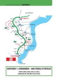
SASSO SAN MARTINO E MONTI DI NAVA<br />
Splen<strong>di</strong>da passeggiata che risale il Sasso San<br />
Mart<strong>in</strong>o, da dove lo sguardo può spaziare <strong>in</strong> tutte<br />
le <strong>di</strong>rezioni.<br />
Punto <strong>di</strong> partenza: Parcheggio <strong>di</strong> Rogaro 2 km<br />
sopra Tremezzo (360 m)<br />
It<strong>in</strong>erario: Parcheggio <strong>di</strong> Rogaro - Monti <strong>di</strong><br />
Pilone - Sasso San Mart<strong>in</strong>o - Monti <strong>di</strong> Pilone -<br />
Monti <strong>di</strong> Nava - Parcheggio <strong>di</strong> Rogaro<br />
Durata totale ore: 4.00<br />
Dislivello: 540 m. circa<br />
Difficoltà: percorso per escursionisti - attenzione<br />
nel tratto che porta da Monti Piloni ai Monti <strong>di</strong><br />
Nava, - consigliate buone scarpe da trekk<strong>in</strong>g<br />
Percorso <strong>in</strong> auto: Da Tremezzo, all’altezza del<br />
parco Olivelli, si imbocca via Peduzzi, che poi<br />
<strong>di</strong>venta via Ugo Ricci, che conduce verso le frazioni.<br />
Dopo ca. 300 m si gira a destra per la frazione<br />
<strong>di</strong> Rogaro. Si supera il ristorante Rusall e<br />
dopo ca. 300 m. si giunge al parcheggio. (per<br />
raggiungere il parcheggio a pie<strong>di</strong> ve<strong>di</strong> it<strong>in</strong>erario<br />
2 - durata 0h30 - <strong>di</strong>slivello 160 m)<br />
Percorso a pie<strong>di</strong>: Dal parcheggio <strong>di</strong> Rogaro si<br />
prosegue un altro cent<strong>in</strong>aio <strong>di</strong> metri per prendere<br />
a s<strong>in</strong>istra la strada per S. Mart<strong>in</strong>o (cartello).<br />
Appena superato un uliveto si raggiunge un<br />
<strong>in</strong>crocio, dove si prosegue <strong>di</strong>ritto. Sulla destra si<br />
passa accanto ad un’area a<strong>di</strong>bita al recupero dei<br />
cervi, per poi scendere <strong>in</strong> una stretta valle. Si<br />
risale l’altro versante della valle seguendo la<br />
ripida scal<strong>in</strong>ata. Dopo un tratto rilassante con<br />
una bellissima vista su Bellagio, si risale una<br />
ripida scal<strong>in</strong>ata che esce sui prati degradanti del<br />
Monte Crocione. Si avanza verso la parete rocciosa<br />
del Sasso San Mart<strong>in</strong>o e, attenzione,<br />
appena superata una casc<strong>in</strong>a <strong>di</strong>roccata, e all’altezza<br />
dell’<strong>in</strong>izio <strong>di</strong> una r<strong>in</strong>ghiera, si svolta a s<strong>in</strong>istra<br />
per Pilone - Forcolette (<strong>in</strong><strong>di</strong>cazione sulla<br />
roccia), lasciando cosi il sentiero che porta alla<br />
chiesa <strong>di</strong> San Mart<strong>in</strong>o. Il sentiero si alza a tornant<strong>in</strong>i<br />
<strong>in</strong> mezzo ai ripi<strong>di</strong> prati con una vista<br />
mozzafiato sulla piana <strong>di</strong> Rogaro, Griante e la<br />
chiesetta <strong>di</strong> San Mart<strong>in</strong>o. Il sentiero entra <strong>in</strong> una<br />
profonda gola offrendo degli scorci suggestivi<br />
del lago per giungere alle casc<strong>in</strong>e <strong>di</strong> Monti<br />
Pilone 800 m - ore 1.30 dalla partenza.<br />
Qui si lascia il sentiero che porta ai Monti <strong>di</strong><br />
Nava e si devia a destra per il Sasso San<br />
Mart<strong>in</strong>o. Arrivati al tavolo pic-nic si attraversa il<br />
gruppo <strong>di</strong> casc<strong>in</strong>e e dopo un cent<strong>in</strong>aio <strong>di</strong> metri al<br />
bivio, si prende a destra per Sasso San Mart<strong>in</strong>o<br />
ignorando il sentiero per Croce (frazione <strong>di</strong><br />
<strong>Menaggio</strong>).<br />
Il sentiero sale a tornanti sul versante nord per<br />
poi portarsi sul lato meri<strong>di</strong>onale del Dosso.<br />
Dopo ca. 10 m<strong>in</strong>uti <strong>di</strong> salita si riscende alla<br />
conca sottostante per poi <strong>di</strong>rigersi verso l’estremità<br />
del Sasso San Mart<strong>in</strong>o (818 m - ore 2.00<br />
dalla partenza). Da qui lo sguardo può spaziare<br />
<strong>in</strong> tutte le <strong>di</strong>rezioni: il centro lago contornato<br />
dalle Grigne e tutto l’alto Lario con <strong>Menaggio</strong> <strong>in</strong><br />
primo piano. Questa zona faceva parte della l<strong>in</strong>ea<br />
Cadorna, la l<strong>in</strong>ea <strong>di</strong> <strong>di</strong>fesa costruita durante la<br />
prima guerra mon<strong>di</strong>ale, che ha lasciato <strong>in</strong> memoria<br />
le sue tr<strong>in</strong>cee e appostamenti. Si ritorna sui<br />
propri passi f<strong>in</strong>o ai Monti Pilone per riprendere il<br />
sentiero che sale ai monti <strong>di</strong> Nava. Il sentiero si<br />
str<strong>in</strong>ge e sale a ripi<strong>di</strong> tornanti. Nel corso della<br />
salita <strong>in</strong>contrerete due piccole frane, f<strong>in</strong>o a giungere<br />
ad un largo sentiero erboso che attraversa<br />
prima <strong>in</strong> piano e poi <strong>in</strong> <strong>di</strong>scesa il Dossone.<br />
Si sbuca su uno sterrato <strong>in</strong> località monti <strong>di</strong> Nava<br />
(885 m ore 3.00 dalla partenza) all’altezza <strong>di</strong> una<br />
cappella votiva. Si prende a s<strong>in</strong>istra seguendo un<br />
piccolissimo tratto della “Via dei Monti<br />
Lariani” sentiero n° 2 (percorso <strong>di</strong> trekk<strong>in</strong>g<br />
lungo 125 km che collega i monti sulla sponda<br />
ovest del lago). Dopo ca 400 m, all’altezza dell’ultima<br />
casa dei monti <strong>di</strong> Nava, si lascia la “Via<br />
dei Monti Lariani”, e si prende a s<strong>in</strong>istra per<br />
imboccare la strada <strong>in</strong> cemento che costeggia<br />
l’ultimo abitato dei monti <strong>di</strong> Nava (segnavia<br />
Griante).<br />
Si scende a tornanti verso il lago con ampia vista<br />
sul promontorio <strong>di</strong> Lavedo e i paesi <strong>di</strong><br />
Tremezzo, Mezzegra e Lenno. Più avanti il sentiero<br />
tenderà sul versante sovrastante Griante con<br />
una bella vista sul Sasso San Mart<strong>in</strong>o e l’omonima<br />
chiesetta. Si passa la deviazione per la cappella<br />
degli alp<strong>in</strong>i, raggiungibile <strong>in</strong> 10 m<strong>in</strong>uti;<br />
subito dopo, ad un altro bivio, si tiene la s<strong>in</strong>istra<br />
per giungere <strong>in</strong> breve al parcheggio <strong>di</strong> Rogaro.
SASSO SAN MARTINO E MONTI DI NAVA 3<br />
Splen<strong>di</strong>d walk that leeds up to Sasso San<br />
Mart<strong>in</strong>o from where the wonderful view faces all<br />
<strong>di</strong>rections.<br />
Start<strong>in</strong>g po<strong>in</strong>t of the walk : Park<strong>in</strong>g lot at Rogaro<br />
2 km above Tremezzo (360 m)<br />
It<strong>in</strong>erary: Parcheggio <strong>di</strong> Rogaro - Monti <strong>di</strong> Pilone<br />
- Sasso San Mart<strong>in</strong>o - Monti <strong>di</strong> Pilone - Monti <strong>di</strong><br />
Nava - Parcheggio <strong>di</strong> Rogaro<br />
Duration of the walk: 4.00<br />
Ascent: 540 m.<br />
Difficulty: A walk for tra<strong>in</strong>ed hikers – some small<br />
landslips are between Pilone and Monti <strong>di</strong> Nava.<br />
Good hik<strong>in</strong>g boots are recommended.<br />
Car route from Tremezzo to the park<strong>in</strong>g lot of<br />
Rogaro:At Tremezzo, near the park Olivelli, you pick<br />
up via Peduzzi which turns <strong>in</strong>to via Ugo Ricci. After<br />
300 m turn right <strong>in</strong> the <strong>di</strong>rection of Rogaro. Past the<br />
restaurant Rusall, cont<strong>in</strong>ue another 400 m <strong>in</strong> order to<br />
reach the park<strong>in</strong>g lot on the left with a picnic area. (For<br />
those who wish to reach the park<strong>in</strong>g lot by foot, it<br />
takes 0h30 with an ascent of 160 m - see it<strong>in</strong>erary 1.)<br />
Route by foot: From the park<strong>in</strong>g lot at Rogaro proceed<br />
another 100 m on the paved road and then pick<br />
up the cart track to the left to San Mart<strong>in</strong>o (sign). At<br />
<strong>in</strong>tersection, just past a small olive grove, cont<strong>in</strong>ue<br />
straight on. On the right you will notice an area used<br />
by the wildlife rangers as recovery for deer that have<br />
been either wounded or rejected by their mother. You<br />
descend <strong>in</strong>to a small valley and then ascend its opposite<br />
side either over the steep trail or along the steep<br />
steps. The trail then follows a more relax<strong>in</strong>g stretch<br />
with a great view of Bellagio. A steep flight of steps<br />
br<strong>in</strong>gs you to the degrad<strong>in</strong>g fields of the Monte<br />
Crocione while advanc<strong>in</strong>g towards the impress<strong>in</strong>g<br />
rocky face of Sasso San Mart<strong>in</strong>o. Attention: just past<br />
the ru<strong>in</strong>s of a farmstead and at the beg<strong>in</strong>n<strong>in</strong>g of a guard<br />
rail, turn left for Pilone - Forcolette (pa<strong>in</strong>ted sign on the<br />
rock). You will be leav<strong>in</strong>g the trail that leads to the<br />
church of San Mart<strong>in</strong>o. The trail ascends <strong>in</strong> small<br />
bends among the steep fields with a breathtak<strong>in</strong>g view<br />
of the pla<strong>in</strong> of Rogaro, Griante and the church of San<br />
Mart<strong>in</strong>o. The path enters a deep narrow section that<br />
offers suggestive views between the rocks of the lake.<br />
You then arrive at the build<strong>in</strong>gs of Monte Pilone, 800<br />
m and 1h30 from the park<strong>in</strong>g lot at Rogaro. You abandon<br />
the path that cont<strong>in</strong>ues to Monti <strong>di</strong> Nava <strong>in</strong> order<br />
to reach Sasso San Mart<strong>in</strong>o. You head towards the picnic<br />
table and walk between the build<strong>in</strong>gs. After 150 m<br />
there is an <strong>in</strong>tersection where you take to the right for<br />
Sasso San Mart<strong>in</strong>o. In the beg<strong>in</strong>n<strong>in</strong>g the path w<strong>in</strong>ds<br />
up <strong>in</strong> bends on the northern part of the hill before turn<strong>in</strong>g<br />
to the southern face. After an accent of about 10<br />
m<strong>in</strong>utes the trail descends to a wide grassy bas<strong>in</strong>. From<br />
here the trail leads to the most outer po<strong>in</strong>t of Sasso San<br />
Mart<strong>in</strong>o, 818 m and 2h00 from departure. The view<br />
faces all <strong>di</strong>rections: the Centre Lake area with the<br />
Grigne mounta<strong>in</strong>s on the background, and the whole<br />
northern end of the lake with <strong>Menaggio</strong> <strong>in</strong> the foreground.<br />
This area was part of the great defence l<strong>in</strong>e<br />
called “L<strong>in</strong>ea Cadorna”, built <strong>in</strong> 1915 along the<br />
Swiss-Italian border, to block a possible German<br />
offence. In the prov<strong>in</strong>ce of Como it extended from<br />
Monte Bisb<strong>in</strong>o near Como to Sasso Cordona, Monte<br />
Galbiga and Monte Crocione and from there down to<br />
Sasso San Mart<strong>in</strong>o and the Crocetta. In fact you can<br />
notice trenches and defence posts. After you have<br />
enjoyed the view, return on your previous path to<br />
Monte Pilone. Here you pick up the trail that ascends<br />
to Monti <strong>di</strong> Nava. The path w<strong>in</strong>ds up <strong>in</strong> bends and<br />
comes <strong>in</strong>to an area of landslips where you must pay<br />
attention. The ascent f<strong>in</strong>ishes right <strong>in</strong> front of a large<br />
grassy trail situated between two slopes. Follow this,<br />
first flat, then downhill trail across the Dossone to<br />
Monti <strong>di</strong> Nava, 885m and 3h00 from the departure.<br />
The trail ends on a cart track near a small shr<strong>in</strong>e. Turn<br />
left. This cart track is part of the Via dei Monti Lariani<br />
path 2, a trekk<strong>in</strong>g tour of 125 km which connects the<br />
mounta<strong>in</strong> settlements on the west side of the lake.<br />
After 400 m at the height of the last houses of Monti<br />
<strong>di</strong> Nava (sign Griante), you leave the Via dei Monti<br />
Lariani and pick up the trail paved with cement which<br />
passes along the last houses of Monti <strong>di</strong> Nava. The<br />
track leads down <strong>in</strong> wide bends with a most beautiful<br />
view of the pen<strong>in</strong>sula of Lavedo, and the towns of<br />
Tremezzo, Mezzegra and Lenno. It then turns to the<br />
slope above Griante with a splen<strong>di</strong>d view of Sasso San<br />
Mart<strong>in</strong>o and the little church. You pass the deviation<br />
for the “Cappella degli Alp<strong>in</strong>i” (reachable <strong>in</strong> 10 m<strong>in</strong>utes)<br />
and shortly after you arrive at a fork, where you<br />
keep left. You aga<strong>in</strong> reach the pla<strong>in</strong> of Rogaro and end<br />
on the paved road right next to the park<strong>in</strong>g lot of<br />
Rogaro.
4<br />
DA LENNO A TREMEZZO<br />
<strong>Passeggiate</strong> per strade secondarie e vecchie mulattiere<br />
che collegano nuclei abitati <strong>di</strong> grande <strong>in</strong>teresse<br />
storico. L’escursione si snoda appena sopra il lago,<br />
tra vecchi palazzi, maestose ville, suggestivi vicoli e<br />
piazzette.<br />
It<strong>in</strong>erario: Lenno - Mezzegra - Pola - Bonzanigo -<br />
Viano - Intignano - Volesio - Balogno - Tremezzo<br />
Durata totale: ore 2.00<br />
Dislivello: 80 m. circa<br />
Difficoltà: facile<br />
Collegamenti da Tremezzo per Lenno: aliscafo,<br />
battello, autobus l<strong>in</strong>ea C10<br />
Percorso: Dall’imbarcadero <strong>di</strong> Lenno si segue il<br />
lungo lago a s<strong>in</strong>istra (Viale C. Lomazzi) f<strong>in</strong>o a<br />
raggiungere la piazza XI Febbraio, dove si trovano<br />
la chiesa <strong>di</strong> S. Stefano e l’antico battistero<br />
ottagonale, databile alla seconda metà dell’XI<br />
secolo.<br />
Si attraversa la statale tramite il sottopassaggio,<br />
qu<strong>in</strong><strong>di</strong> ci si <strong>di</strong>rige a s<strong>in</strong>istra e appena oltrepassato<br />
l’ufficio postale (poco <strong>di</strong>stante dalla fermata del<br />
bus) si imbocca il viottolo a s<strong>in</strong>istra per il<br />
Santuario della B.V. del Soccorso.<br />
Si sale leggermente per ca. 200 m e dopo aver passato<br />
sulla destra “La Cooperativa” ci si immette a<br />
destra nella via omonima che corre <strong>di</strong>etro al<br />
campo <strong>di</strong> bocce. Imboccare subito il viottolo selciato<br />
sulla destra seguendo l’<strong>in</strong><strong>di</strong>cazione ru<strong>di</strong>mentale<br />
per Mezzegra - Pola, per poi scendere una<br />
scal<strong>in</strong>ata che conduce ad un ponte sopra il torrente<br />
Pola. Si risale l’altro versante della valletta f<strong>in</strong>o<br />
a Pola, frazione <strong>di</strong> Mezzegra.<br />
Ci si immette su una strada asfaltata e la si segue<br />
per ca. 500 metri, per poi svoltare a s<strong>in</strong>istra <strong>in</strong> Via<br />
Pola Vecchia. Ci si trova ora su un tratto della<br />
Green Way (passeggiata <strong>di</strong> ca. 10 km che collega<br />
Colonno a Cadennabia). Sbucati <strong>in</strong> Via G.<br />
Brentano la si percorre a destra, passando il modesto<br />
oratorio <strong>di</strong> San Giuseppe del primo<br />
Settecento, f<strong>in</strong>o alla chiesa <strong>di</strong> S. Abbon<strong>di</strong>o, dal cui<br />
piazzale si gode <strong>di</strong> una bella vista del lago.<br />
Probabilmente fondata nel XII secolo, la chiesa è<br />
stata poi ricostruita nel 1702 ad opera <strong>di</strong> emigrati<br />
locali. Passata la chiesa, si prosegue sulla strada <strong>in</strong><br />
<strong>di</strong>scesa per arrivare al settecentesco Palazzo<br />
Brentano. L’antico palazzo apparteneva alla<br />
potente famiglia lariana, che fecero la loro fortuna<br />
con il commercio soprattutto <strong>in</strong> Olanda e<br />
Germania. I mercanti della Tremezz<strong>in</strong>a, partiti<br />
come mercanti <strong>di</strong> agrumi, olio d’oliva, alloro e<br />
castagne prodotti del territorio, occuparono posti<br />
chiave del commercio europeo. In tutte le città del<br />
nord dove la Compagnia delle In<strong>di</strong>e Orientali portava<br />
le prime spezie, c’erano rappresentanti delle<br />
famiglie Brentano, Ma<strong>in</strong>oni, P<strong>in</strong>i e Carli. Con il<br />
tempo molti <strong>di</strong> questi commercianti si arricchirono<br />
notevolmente e costruirono nei loro paesi natali<br />
splen<strong>di</strong><strong>di</strong> palazzi.<br />
Si attraversa il nucleo antico <strong>di</strong> Bonzanigo (si consiglia<br />
<strong>di</strong> esplorare i suggestivi vicoli) per poi sbucare<br />
sulla strada nei pressi del Palazzo Rosati del<br />
XVII secolo con all’<strong>in</strong>terno notevoli affreschi.<br />
Qui si lascia la Greenway e si prosegue <strong>di</strong>ritto per<br />
arrivare subito ad un piccolo parcheggio.<br />
Ignorando la Via delle Mele si imbocca a s<strong>in</strong>istra<br />
il viale <strong>in</strong> salita che conduce <strong>in</strong> mezzo ad un uliveto<br />
<strong>in</strong> una bella posizione soleggiata e riparata.<br />
In fondo al viale si volta a destra, arrivati ad un<br />
lavatoio nella frazione <strong>di</strong> Viano, si segue a s<strong>in</strong>istra<br />
Via Ma<strong>in</strong>one d’Intignano e al bivio si percorre a<br />
s<strong>in</strong>istra Via Interna. In fondo alla via prendere a<br />
destra poi subito a s<strong>in</strong>istra per arrivare alla chiesetta<br />
<strong>di</strong> San Rocco, costruita dagli abitanti della<br />
frazione nel 1690; la si supera, poi, sul tornante,<br />
salire a s<strong>in</strong>istra per Via Romolo Quagl<strong>in</strong>o; dopo<br />
circa 100 metri si arriva alla frazione <strong>di</strong> Intignano.<br />
Si cont<strong>in</strong>ua sempre <strong>di</strong>ritto s<strong>in</strong>o alla f<strong>in</strong>e del paese<br />
e si scende lungo il vialotto che costeggia la piccola<br />
valle.<br />
Passati davanti a un altro lavatoio si giunge alla<br />
frazione <strong>di</strong> Volesio e si prosegue sempre <strong>di</strong>ritto <strong>in</strong><br />
<strong>di</strong>scesa; sulla s<strong>in</strong>istra notare al n° 12 il portone <strong>di</strong><br />
Palazzo Ma<strong>in</strong>oni. Poco avanti sempre sulla s<strong>in</strong>istra,<br />
si <strong>in</strong>contra la chiesa dei SS. Pietro e Paolo,<br />
mentre sull’arcata posta <strong>di</strong> fronte alla chiesa è<br />
ancora visibile lo stemma dei Carli.<br />
Si cont<strong>in</strong>ua <strong>di</strong>ritto <strong>in</strong> via Monte Crocione <strong>in</strong>tersecando<br />
la strada che sale da Tremezzo. Si prosegue<br />
la <strong>di</strong>scesa <strong>in</strong> Via Crocione e dopo aver attraversato<br />
una seconda via asfaltata si giunge sulla statale<br />
all’altezza dell’Hotel Villa Marie all’estremità sud<br />
del paese <strong>di</strong> Tremezzo.
DA LENNO A TREMEZZO 4<br />
This walk leads over secondary roads, alley-ways,<br />
and old cobble stone tracks through small hamlets of<br />
historical <strong>in</strong>terest among old palaces, antique houses<br />
and churches, and picturesque village squares.<br />
Start<strong>in</strong>g po<strong>in</strong>to of the walk: Lenno<br />
It<strong>in</strong>erary: Lenno - Mezzegra - Bonzanigo - Viano -<br />
Volesio - Balogno - Tremezzo<br />
From Tremezzo to Lenno: by busl<strong>in</strong>e C10 by boat<br />
or hydrofoil<br />
Ascent: 80m<br />
Total walk<strong>in</strong>g time: 2.00 hrs.<br />
Difficulty: easy<br />
At Lenno, from the boat land<strong>in</strong>gstage, you follow<br />
the lake side to the left (Viale C. Lomazzi) <strong>in</strong> ordeR<br />
to reach the church square called piazza XI Febbraio<br />
where the church St. Stefano and the XII century<br />
baptistery stand. Cross the ma<strong>in</strong> road (there is an<br />
underpass), head north and just past the post office<br />
(close to the bus stop) pick up the alley to the left <strong>in</strong><br />
the <strong>di</strong>rection of the Santuario della B.V. del<br />
Soccorso. It leads slightly uphill and after 200 m just<br />
past a build<strong>in</strong>g with the writ<strong>in</strong>g “La Coopertiva”,<br />
pick up the via “Cooperativa” to the right.<br />
It leads beh<strong>in</strong>d the “bocce game” of the<br />
Cooperativa. Turn ime<strong>di</strong>ately <strong>in</strong>to the lane on the<br />
right follow<strong>in</strong>g the ru<strong>di</strong>mental sign for Mezzagra –<br />
Pola. You then follow a flight of steps that lead<br />
down to a little bridge over the stream Pola. Ascend<br />
the opposte side of the valley <strong>in</strong> order to reach Pola,<br />
part of the township of Mezzegra.<br />
You follow the paved secondary road for about<br />
500m and then pick up “Via Pola Vecchia” on the<br />
left. You now f<strong>in</strong>d yourself on a stretch of the<br />
Greenway, a walk of about 10 km <strong>in</strong> between<br />
Colonno and Cadenabbia.<br />
You come out onto via Brentano which you follow<br />
to the right, past the oratory of San Giuseppe (built<br />
at the beg<strong>in</strong>n<strong>in</strong>g of the 17 th century), to the church<br />
of S. Abbon<strong>di</strong>o. From the churchyard you have a<br />
nice view of the lake. The church was probably<br />
founded <strong>in</strong> the XII century but rebuilt <strong>in</strong> the 17th<br />
century, spar<strong>in</strong>g the old roman church on the right<br />
now used as parish house.<br />
From the church you cont<strong>in</strong>ue along via Brentano<br />
and slightly downhill you arrive at Palazzo<br />
Brentano. This palace of the 17 th century was built<br />
by the <strong>in</strong>fluent local Brentano family, who made<br />
their fortune as merchants, ma<strong>in</strong>ly <strong>in</strong> Holland and<br />
Germany.<br />
They left their native towns, like other local families,<br />
as merchants of local the products such as<br />
lemons, chesnuts and olive oil, and achieved posi-<br />
tions <strong>in</strong> the European commerce. In all the towns of<br />
northern Europe where the East In<strong>di</strong>an Trade<br />
Company brought the first spices, there was a member<br />
of these local families like the Brentano,<br />
Ma<strong>in</strong>oni, P<strong>in</strong>i and Carli. With time some of these<br />
merchants became so rich that it enabled them to<br />
built beautiful palaces <strong>in</strong> their native towns.<br />
Part of Palazzo Brentano is nowadays used as<br />
townhall. You pass through the antique urban centre<br />
of Bozzanigo - we reccomend a stroll through its little<br />
alleys - and then you end up on the paved road<br />
near Palazzo Rosati of the 17th century.<br />
Here you leave the Green Way and proceed straight<br />
on to a small park<strong>in</strong>g lot. Ignore the Via delle Mele<br />
and pick up the small lane that ascends through an<br />
olive grove with a nice view of Mezzegra.<br />
At the end of the lane, turn right and, at the washhouse<br />
<strong>in</strong> the hamlet of Viano, follow via Ma<strong>in</strong>oni<br />
d’Intignano to the left.<br />
At the next <strong>in</strong>tersection pick up via Interna on the<br />
left. At the end of the street turn right and then left<br />
past the little church San Rocco, built <strong>in</strong> 1690. At the<br />
next bend, turn left <strong>in</strong>to via Romolo Quagl<strong>in</strong>o which<br />
leads uphill to the hamlet Intignano. Cont<strong>in</strong>ue<br />
straight on till the end of the town. A track leads<br />
downhill along the valley and just past the public<br />
wash place you enter the hamlet Volesio.<br />
Cont<strong>in</strong>ue the descent along via Monte Crocione<br />
and note on the left, at house n° 12, the portal of<br />
Palazzo Ma<strong>in</strong>oni with the family coat of arms on<br />
the arcade. Slightly ahead thare is the little church<br />
of San Pietro and Paolo, and on the arcade opposite<br />
the church the family coat of arms of the Carli<br />
family is still visible. Cont<strong>in</strong>ue along via Monte<br />
Crocione and cross the road that leads up from<br />
Tremezzo.<br />
You then cross another paved road <strong>in</strong> order to follow<br />
the cont<strong>in</strong>uation of Via Monte Crocione. This leads<br />
down to the lake side road near the entrance gate of<br />
Hotel Villa Marie at the southern end of Tremezzo.
5<br />
SANTUARIO BEATA VERGINE DEL SOCCORSO<br />
Breve ma suggestiva passeggiata con partenza da<br />
Lenno e salita al Sacro Monte <strong>di</strong> Ossuccio, che<br />
lungo la Via Crucis, costituita da quattor<strong>di</strong>ci cappelle<br />
con statue a grandezza naturale, conduce al<br />
Santuario della Beata Verg<strong>in</strong>e del Soccorso.<br />
Questo raro esempio <strong>di</strong> via Crucis nel 2003 è<br />
entrato far parte del patrimonio dell’Unesco.<br />
It<strong>in</strong>erario: Lenno - Santuario Beata Verg<strong>in</strong>e del<br />
Soccorso - Ossuccio - Campo - Lenno<br />
Dislivello: 200 m.<br />
Durata totale: ore 1.30<br />
Difficoltà: facile<br />
Collegamenti: da Tremezzo per Lenno: <strong>in</strong> battello,<br />
aliscafo, <strong>in</strong> autobus l<strong>in</strong>ea C10,<br />
Dall’imbarcadero <strong>di</strong> Lenno si segue il lungo lago<br />
a s<strong>in</strong>istra (Viale C. Lomazzi) f<strong>in</strong>o a raggiungere la<br />
piazza XI Febbraio, dove si trovano la chiesa <strong>di</strong> S.<br />
Stefano e l’antico battistero ottagonale, databile<br />
alla seconda metà dell’XI secolo. Si attraversa la<br />
statale tramite un sottopassaggio, qu<strong>in</strong><strong>di</strong> ci si <strong>di</strong>rige<br />
a s<strong>in</strong>istra e appena oltrepassato l’ufficio postale<br />
(poco <strong>di</strong>stante dalla fermata del bus) si imbocca<br />
il viottolo a s<strong>in</strong>istra per il Santuario della B.V.<br />
del Soccorso.<br />
Dopo aver passato “La Cooperativa”, si prosegue<br />
per circa 50 metri e si volta a s<strong>in</strong>istra passando<br />
davanti alla chiesa della Santissima Tr<strong>in</strong>ità. Al<br />
bivio, si volta a destra per Via Don Cadenazzi per<br />
poi imboccare Viale Libronico a s<strong>in</strong>istra.<br />
Proseguendo sempre <strong>di</strong>ritto si ignora il bivio per<br />
l’Abbazia dell’Acquafredda che si può <strong>in</strong>travedere<br />
<strong>in</strong> alto sulla destra. Al prossimo bivio, girare<br />
a destra per sbucare su una strad<strong>in</strong>a, che si segue<br />
a destra (a s<strong>in</strong>istra si trova il nucleo storico <strong>di</strong><br />
Molgisio); al bivio successivo, dal quale si può già<br />
vedere la prima cappella, si prende a s<strong>in</strong>istra ignorando<br />
la Via ai Monti. Le cappelle del Sacro<br />
Monte racchiudono scene rappresentanti i fatti<br />
della vita <strong>di</strong> Gesù e della Madonna e sono raffigurati<br />
con affreschi e statue <strong>in</strong> stucco e terracotta <strong>di</strong><br />
grandezza naturale. Esse furono realizzate tra il<br />
1635 e il 1714 ad opera <strong>di</strong> vari artisti comaschi e<br />
tic<strong>in</strong>esi. La prima cappella è de<strong>di</strong>cata all’annunciazione<br />
dell’Angelo a Maria Verg<strong>in</strong>e, da qui<br />
com<strong>in</strong>cia la salita della Via Crucis che lungo un<br />
viale acciottolato, conduce al Santuario. Una cappelletta<br />
<strong>in</strong> frazione Mol<strong>in</strong>a custo<strong>di</strong>va una statua<br />
della Madonna col Bamb<strong>in</strong>o, la quale fama miracolosa<br />
<strong>in</strong>dusse a fondare nel 1537 una più ampia<br />
chiesa per custo<strong>di</strong>rla. Il sacro Monte <strong>di</strong> Ossuccio<br />
nel 2003 fu <strong>di</strong>chiarato Patrimonio dell’Umanità.<br />
Dopo la visita alla chiesa si torna sui propri passi<br />
f<strong>in</strong>o ad arrivare alla IV cappella nei pressi del bar<br />
Riposo, si prosegue <strong>di</strong>ritto tenendo la s<strong>in</strong>istra per<br />
circa 800 m per arrivare alla chiesa <strong>di</strong> St.<br />
Eufemia e V<strong>in</strong>cenzo. Questo e<strong>di</strong>ficio, oggi chiesa<br />
parrocchiale venne costruito dopo che l’omonima<br />
chiesa che sorgeva sull’Isola Comac<strong>in</strong>a,<br />
venne <strong>di</strong>strutta nel 1169. Si volta a s<strong>in</strong>istra passando<br />
sotto il campanile, si scende a s<strong>in</strong>istra superando<br />
l’ufficio postale. Attraversata la statale, 20<br />
metri più avanti, si prende la strad<strong>in</strong>a sulla destra<br />
che conduce d<strong>in</strong>nanzi al cancello della bellissima<br />
Villa Balbiano caratterizzata dagli <strong>in</strong>triganti giochi<br />
d’acqua del suo parco, qu<strong>in</strong><strong>di</strong> si oltrepassa il<br />
fiume della Val Perlana attraversando un ponticello,<br />
si entra nel nucleo storico <strong>di</strong> Campo e qui,<br />
imboccata la Via Reg<strong>in</strong>a, si giunge davanti al portone<br />
della Villa Monastero che sorge sulla base<br />
<strong>di</strong> un’ antico convento <strong>di</strong> suore Benedett<strong>in</strong>e. Ora<br />
si prosegue a s<strong>in</strong>istra e seguendo la scal<strong>in</strong>ata <strong>in</strong><br />
salita si supera l’antico ponte pedonale sopra la<br />
statale, sul tratto della Vecchia Strada Reg<strong>in</strong>a, si<br />
prosegue <strong>di</strong>ritto e dopo circa 300 metri si giunge<br />
<strong>di</strong> nuovo sulla statale, la si attraversa per imboccare<br />
subito dopo il proseguimento della Vecchia<br />
Reg<strong>in</strong>a. Giunti al bivio riconoscibile dalla presenza<br />
<strong>di</strong> una fontana, si imbocca il Vicolo Guido<br />
Delmati sulla destra, dopo alcuni metri sulla s<strong>in</strong>istra<br />
vi è una torre eretta probabilmente per motivi<br />
<strong>di</strong> controllo sul passaggio e a<strong>di</strong>bita alla riscossione<br />
dei tributi. In breve si giunge sul lungolago nel<br />
bellissimo Golfo <strong>di</strong> Venere che si costeggia a s<strong>in</strong>istra<br />
per poi arrivare <strong>di</strong> nuovo nella piazza <strong>di</strong><br />
Lenno.<br />
Si ricorda che sulla punta del promontorio Lavedo<br />
si trova Villa Balbianello costruita alla f<strong>in</strong>e del<br />
1700 per il Card<strong>in</strong>ale Dur<strong>in</strong>i. La villa è visitabile<br />
da metà marzo a metà novembre dalle 10 alle 18.<br />
Chiusura: lunedì e mercoledì. Dal Lido <strong>di</strong> Lenno<br />
è istituito un regolare servizio <strong>di</strong> motoscafi per<br />
accedere alla villa. Solo nei giorni <strong>di</strong> martedì<br />
sabato e domenica, è consentito l’accesso a pie<strong>di</strong><br />
Tel. 0344 56110
SANTUARIO BEATA VERGINE DEL SOCCORSO 5<br />
A small but <strong>in</strong>terest<strong>in</strong>g walk start<strong>in</strong>g at Lenno to the<br />
“Sacro Monte of Ossuccio,” along the sacred walkway<br />
l<strong>in</strong>ed with 14 shr<strong>in</strong>es with natural size statues, to the<br />
“Santuario della Beata Verg<strong>in</strong>e del Soccorso”. The<br />
Sacro Monte has been registered s<strong>in</strong>ce 2003 on the list<br />
of the Humanity World Heritage.<br />
It<strong>in</strong>erary: Lenno - Santuario della Beata Verg<strong>in</strong>e<br />
del Soccorso - Ossuccio - Campo - Lenno<br />
Time required: 1.30<br />
Ascent: 200 m<br />
Difficulty: Easy<br />
Connections: From Tremezzo you can reach<br />
Lenno by bus l<strong>in</strong>e C10, by boat or hydrofoil.<br />
At Lenno, from the boat land<strong>in</strong>g stage, you follow<br />
the lakeside to the left (Viale C. Lomazzi) <strong>in</strong> order to<br />
reach the church square called Piazza XI Febbraio,<br />
where the church St. Stefano and the XII century<br />
baptistery stand. Cross the ma<strong>in</strong> road (there is an<br />
underpass), head north, and just past the post office<br />
(close to the bus stop) pick up the alley to the left <strong>in</strong><br />
the <strong>di</strong>rection of the Santuario della B.V. del<br />
Soccorso. After 200 m you pass a build<strong>in</strong>g with the<br />
writ<strong>in</strong>g “La Cooperativa” on the right. Cont<strong>in</strong>ue<br />
another 30 m, then turn left past the church of the<br />
Santissima Tr<strong>in</strong>ità. After about 20 m at the <strong>in</strong>tersection,<br />
ignore via Rima, and turn right <strong>in</strong>to Via Don<br />
Cadenazzi. Ascend the steps <strong>in</strong> order to reach Viale<br />
Libronico, which you follow to the left. Ignore the<br />
turn off for the “Abbazia dell’Acquafredda,” the<br />
abbey stand<strong>in</strong>g slightly uphill on the right, founded<br />
<strong>in</strong> 1153. At the next <strong>in</strong>tersection turn right. The road<br />
leads on to a cobblestone path which you follow to<br />
the right (on the left is the antique settlement of<br />
Molgisio). At the next <strong>in</strong>tersection cont<strong>in</strong>ue left<br />
ignor<strong>in</strong>g the Via ai Monti. You soon arrive at the first<br />
shr<strong>in</strong>e. Popular devotion led to the construction of a<br />
one kilometer long cobble stone walkway l<strong>in</strong>ed with<br />
14 shr<strong>in</strong>es lead<strong>in</strong>g to the Sanctuary. The shr<strong>in</strong>es<br />
depict the scenes of the Madonna’s and Christ’s life<br />
and are represented by frescos and natural size statues<br />
made of stucco and terracotta. They were created<br />
between 1635 and 1714 by various artists of<br />
Como and the Tic<strong>in</strong>o area. You ascend the Via<br />
Crucis, with stops at the shr<strong>in</strong>es to admire the statues,<br />
on to the Sanctuary. Accord<strong>in</strong>g to devotional tales,<br />
the sanctuary was built because of the <strong>di</strong>scovery of a<br />
marble statue of the Virg<strong>in</strong> Mary and Christ Child <strong>in</strong><br />
a cave by a deaf mute shepherd girl. Dur<strong>in</strong>g the 15th<br />
century a small shr<strong>in</strong>e was built to protect the statue<br />
that was believed to be miraculous. The small shr<strong>in</strong>e<br />
was first enlarged and then transformed <strong>in</strong>to a<br />
church. The central part was completed <strong>in</strong> 1537. The<br />
Sacro Monte has been registered s<strong>in</strong>ce 2003 on the<br />
list of the Humanity World Heritage. After your<br />
visit to the church, turn back along the cobble path<br />
as far as the IV shr<strong>in</strong>e. From the little square, <strong>in</strong> front<br />
of the bar Riposo, keep to the left and pick up the<br />
street lead<strong>in</strong>g along the Locanda Garzola. Follow it<br />
downhill for about 800 m till you arrive at the church<br />
St. Eufemia and V<strong>in</strong>cenzo. This build<strong>in</strong>g was built<br />
when the same named church that stood on the<br />
Island Comac<strong>in</strong>a was destroyed <strong>in</strong> 1169 dur<strong>in</strong>g the<br />
war between Como and the Island. Turn left and<br />
walk below the bell tower of the church <strong>in</strong> order to<br />
reach the ma<strong>in</strong> road close to the post office. Cross<br />
the ma<strong>in</strong> road and cont<strong>in</strong>ue left and after 20 m you<br />
pick up a little lane that passes <strong>in</strong> front of a beautiful<br />
villa called Villa Balbiano with a splen<strong>di</strong>d park with<br />
founta<strong>in</strong>s. Then cross the Perlana stream over a<br />
small foot bridge and along “La Via Reg<strong>in</strong>a,” enter<br />
the historic centre of Campo. You reach the doorway<br />
of Villa Monastero, so called because it was built<br />
on the foundations of an antique monastery of the XI<br />
century. Turn left and go up the steps. You cross the<br />
ma<strong>in</strong> road over an old pedestrian bridge and follow<br />
the “Vecchia Strada Reg<strong>in</strong>a” for about 300 m till you<br />
reach the ma<strong>in</strong> road, which you cross <strong>in</strong> order to pick<br />
up its cont<strong>in</strong>uation. At an <strong>in</strong>tersection where there is<br />
a founta<strong>in</strong>, turn right <strong>in</strong>to Vicolo Delmati. It leads<br />
past a watch tower on the left, probably erected as a<br />
tax control post. Soon you reach the lakeside promenade<br />
around the beautiful “Golfo <strong>di</strong> Venere.”<br />
Follow it to the left and you soon reach the square of<br />
Lenno.<br />
On the far end of the pen<strong>in</strong>sula Lavedo stands the<br />
Villa Balbianello built <strong>in</strong> the 17 th century Its beautiful<br />
gardens are open to the public from mid-March<br />
till the beg<strong>in</strong>n<strong>in</strong>g of November. Open<strong>in</strong>g times are<br />
from 10.00 till 18.00, with Mondays and<br />
Wednesdays closed. From the Lido of Lenno<br />
there is a regular taxi boat service to the villa. On<br />
Tuesdays, Saturdays and Sundays the pathway<br />
to the villa, start<strong>in</strong>g beh<strong>in</strong>d the Lido of Lenno, is<br />
open to the public.
6<br />
MONASTERO SAN BENEDETTO<br />
Questo percorso <strong>in</strong>teressantissimo, soprattutto sotto<br />
l’aspetto storico artistico, parte dal Santuario della<br />
Madonna del Soccorso (400 m) situato sopra la<br />
località <strong>di</strong> Ossuccio, all’<strong>in</strong>izio della Val Perlana. Dal<br />
Santuario un sentiero conduce <strong>in</strong> fondo alla Val<br />
Perlana dove sorge il Monastero <strong>di</strong> San Benedetto<br />
(817 m). Dal monastero, percorrendo il lato opposto<br />
della valle, si giunge all’Abbazia dell’Acquafredda<br />
per poi scendere a Lenno, dove f<strong>in</strong>isce l’it<strong>in</strong>erario.<br />
It<strong>in</strong>erario: Lenno - Santuario della Madonna del<br />
Soccorso - Monastero <strong>di</strong> San Benedetto - Abbazia<br />
dell’Acquafredda - Lenno<br />
Durata della passeggiata: 4h,15<br />
Dislivello: 600 m<br />
Difficoltà: alcuni tratti <strong>in</strong> ripida salita e forte <strong>di</strong>scesa<br />
Collegamenti: da Tremezzo per Lenno autobus<br />
l<strong>in</strong>ea C 10 oppure battello o aliscafo.<br />
Dall’imbarcadero <strong>di</strong> Lenno si segue il lungo lago a<br />
s<strong>in</strong>istra (Viale C. Lomazzi) f<strong>in</strong>o a raggiungere la piazza<br />
XI Febbraio, dove si trovano la chiesa <strong>di</strong> S.<br />
Stefano e l’antico battistero ottagonale, databile alla<br />
seconda metà dell’XI secolo. Si attraversa la statale<br />
tramite un sottopassaggio, qu<strong>in</strong><strong>di</strong> ci si <strong>di</strong>rige a s<strong>in</strong>istra<br />
e appena oltrepassato l’ufficio postale (poco <strong>di</strong>stante<br />
dalla fermata del bus) si imbocca il viottolo a s<strong>in</strong>istra<br />
per il Santuario della B.V. del Soccorso.<br />
Il viottolo sale leggermente, dopo aver passato “La<br />
Cooperativa”, si prosegue per circa 50 metri e si volta<br />
a s<strong>in</strong>istra passando davanti alla chiesa della<br />
Santissima Tr<strong>in</strong>ità. Dopo circa 20 metri, al bivio, si<br />
volta a destra per Via Don Cadenazzi per poi imboccare<br />
Viale Libronico a s<strong>in</strong>istra. Proseguendo sempre<br />
<strong>di</strong>ritto si ignora il bivio per l’Abbazia<br />
dell’Acquafredda, che si può <strong>in</strong>travedere <strong>in</strong> alto<br />
sulla destra. Al prossimo bivio, girare a destra<br />
(seguendo le <strong>in</strong><strong>di</strong>cazioni) per sbucare su una strad<strong>in</strong>a,<br />
che si segue a destra (a s<strong>in</strong>istra si trova il nucleo storico<br />
<strong>di</strong> Molgisio); al bivio successivo, dal quale si può<br />
già vedere la prima cappella, si prende a s<strong>in</strong>istra ignorando<br />
la Via ai Monti. Le cappelle del Sacro Monte<br />
racchiudono scene rappresentanti i fatti della vita <strong>di</strong><br />
Gesù e della Madonna e sono raffigurati con affreschi<br />
e statue <strong>in</strong> stucco e terracotta <strong>di</strong> grandezza naturale.<br />
Esse furono realizzate tra il 1635 e il 1714 ad opera <strong>di</strong><br />
vari artisti comaschi e tic<strong>in</strong>esi. La prima cappella è<br />
de<strong>di</strong>cata all’annunciazione dell’Angelo a Maria<br />
Verg<strong>in</strong>e, da qui com<strong>in</strong>cia la salita della Via Crucis che<br />
lungo un viale acciottolato, abbellito da maestosi platani,<br />
conduce al Santuario. Una cappelletta <strong>in</strong> frazione<br />
Mol<strong>in</strong>a custo<strong>di</strong>va una statua della Madonna col<br />
Bamb<strong>in</strong>o, la quale fama miracolosa <strong>in</strong>dusse a fondare<br />
nel 1537 una più ampia chiesa per custo<strong>di</strong>rla. Il<br />
sacro Monte <strong>di</strong> Ossuccio nel 2003 fu <strong>di</strong>chiarato<br />
Patrimonio dell’Umanità.<br />
Dal piazzale del Santuario si sale per la ripi<strong>di</strong>ssima<br />
strada acciottolata che porta alle baite <strong>di</strong> Preda.<br />
Lasciata a s<strong>in</strong>istra la mulattiera per il rifugio <strong>di</strong><br />
Boffalora, si prosegue <strong>di</strong>ritto, <strong>in</strong> leggera salita superando<br />
le baite semi crollate <strong>di</strong> Garubio e Pelenden, <strong>di</strong><br />
antica orig<strong>in</strong>e, legate alla proprietà dei monaci <strong>di</strong> San<br />
Benedetto. Si attraversa il torrente San Benedetto e<br />
qu<strong>in</strong><strong>di</strong> <strong>di</strong>vallando tra larici e p<strong>in</strong>i si giunge al monastero<br />
<strong>di</strong> San Benedetto del un<strong>di</strong>cesimo secolo, un<br />
importante esempio <strong>di</strong> romanico maturo. La chiesa a<br />
tre navate <strong>di</strong>vise da pilastri e con tre absi<strong>di</strong>, fu eretta<br />
<strong>in</strong>torno al 1080. Il monastero (chiostro e fattoria) fu<br />
<strong>in</strong>vece term<strong>in</strong>ato <strong>in</strong>torno al 1090. L’abbandono da<br />
parte degli stessi monaci nel 1298, ne provocarono il<br />
lento ma <strong>in</strong>esorabile degrado. Negli anni c<strong>in</strong>quanta la<br />
chiesa del monastero <strong>di</strong> San Benedetto fu restaurata;<br />
oggi è <strong>in</strong> corso il restauro del monastero. Anche se nei<br />
secoli ha perso la sua orig<strong>in</strong>aria funzione politico ed<br />
economico, il suo fasc<strong>in</strong>o arcano è ancora del tutto<br />
vivo. All’antico monastero sono ancora legate le<br />
popolazioni vic<strong>in</strong>e, ed <strong>in</strong> particolare gli abitanti <strong>di</strong><br />
Ossuccio e <strong>di</strong> Lenno, che si danno convegno per assistere<br />
alla Messa il primo <strong>di</strong> maggio <strong>di</strong> ogni anno Si<br />
prende poi <strong>di</strong>etro la chiesa il sentiero che risale l’altra<br />
parte della Val Perlana.<br />
Si attraversa il torrente Perlana e dopo aver passato<br />
alcuni agglomerati, si giunge <strong>in</strong> forte <strong>di</strong>scesa<br />
all’Abbazia dell’Acquafredda.<br />
L’Abbazia dell’Acquafredda, così chiamata dalla sorgente<br />
che scaturisce sul suo sagrato, fu fondata nel<br />
1147 da Enrico, monaco cistercense dell’Abbazia <strong>di</strong><br />
Morimondo, nella località Roncate (Lenno).<br />
Dell’antica struttura rimane l’abside e la cappella del<br />
vescovo Agripp<strong>in</strong>o, le cui spoglie furono trasportate<br />
dall’Isola Comac<strong>in</strong>a; la chiesa, de<strong>di</strong>cata a S. Maria<br />
dell’Uliveto, è affrescata dal Fiammengh<strong>in</strong>o.<br />
Si scende lungo la strad<strong>in</strong>a che sbuca <strong>di</strong> nuovo <strong>in</strong><br />
Viale Libronico che si segue a s<strong>in</strong>istra.<br />
Da qui si segue la strada <strong>di</strong> andata per tornare alla<br />
fermata dell’autobus oppure all’imbarcadero <strong>di</strong><br />
Lenno.
MONASTERO SAN BENEDETTO 6<br />
This very <strong>in</strong>terest<strong>in</strong>g walk, especially from a historic,<br />
artistic po<strong>in</strong>t of view, starts at the Santuario della<br />
Maddonna del Soccorso (400 m), situated above the<br />
town Ossuccio at the beg<strong>in</strong>n<strong>in</strong>g of the Val Perlana.<br />
From here a path leads deep <strong>in</strong>to the valley Perlana<br />
where the antique monastery San Benedetto (817<br />
m) stands. From here along the opposite eastern side<br />
of the valley you reach the Abbazia<br />
dell’Acquafredda above the town Lenno.<br />
It<strong>in</strong>erary: Lenno – Santuario della B.V. del<br />
Soccorso - Monastero <strong>di</strong> San Benedetto - Abbazia<br />
dell’Acquafredda - Lenno<br />
Total walk<strong>in</strong>g time: 4h,15<br />
Ascent: 600 m<br />
Difficulty: some steep ascents and descents<br />
Connections from Tremezzo to and from Lenno:<br />
bus l<strong>in</strong>e C10 or boat or hydrofoil<br />
At Lenno, from the boat land<strong>in</strong>gstage, you follow the<br />
lake side to the left (Viale C. Lomazzi) <strong>in</strong> order to reach<br />
the church square called piazza XI Febbraio, where the<br />
church St. Stefano and the XII century baptistery<br />
stand. Cross the ma<strong>in</strong> road (there is an underpass),<br />
head north, and just past the post office (close to the bus<br />
stop) pick up the alley to the left <strong>in</strong> the <strong>di</strong>rection of the<br />
Santuario della B.V. del Soccorso. It leads slightly<br />
uphill and after 300 m you pass a build<strong>in</strong>g with the<br />
writ<strong>in</strong>g “La Cooperativa” on the right. Cont<strong>in</strong>ue another<br />
30 m, then turn left past the church of the Santissima<br />
Tr<strong>in</strong>ità.. After about 20 m at the <strong>in</strong>tersection, ignore via<br />
Rima, and turn right <strong>in</strong>to Via Don Cadenazzi. Ascend<br />
the steps <strong>in</strong> order to reach Viale Libronico, which you<br />
follow to the left. Ignore the turn off for the “Abbazia<br />
dell’Acquafredda,” the abbey stand<strong>in</strong>g slightly uphill<br />
on the right. At the next <strong>in</strong>tersection turn right (sign<br />
Madonna del Soccorso). The road leads on to a cobble<br />
stone path which you follow to the right (on the left is<br />
the antique settlement of Molgisio). At the next <strong>in</strong>tersection<br />
cont<strong>in</strong>ue left ignor<strong>in</strong>g the Via ai Monti.<br />
You soon arrive at the first shr<strong>in</strong>e. Popular devotion led<br />
to the construction of a one kilometer long cobble<br />
stone walkway l<strong>in</strong>ed with 14 shr<strong>in</strong>es lead<strong>in</strong>g to the<br />
Sanctuary The shr<strong>in</strong>es depict the scenes of the<br />
Madonna’s and Christ’s life and are represented by<br />
frescos and natural size statues out of stucco and terracotta.<br />
They were created between 1635 and 1714 by<br />
various artists of Como and the Tic<strong>in</strong>o area.<br />
You ascend the Via Crucis to the Sanctuary. Accord<strong>in</strong>g<br />
to devotional tales, the sanctuary was built because of<br />
the <strong>di</strong>scovery of a marble statue of the Virg<strong>in</strong> Mary and<br />
Child. Dur<strong>in</strong>g the 15th century a small shr<strong>in</strong>e was built<br />
to protect the statue that was believed to be miraculous.<br />
The small shr<strong>in</strong>e was first enlarged and then transformed<br />
<strong>in</strong>to a church. The central part was completed<br />
<strong>in</strong> 1537. The Sacro Monte has been registered s<strong>in</strong>ce<br />
2003 on the list of the Humanity World Heritage.<br />
From the church square you follow the steep track<br />
which leads to the farmhouses of Preda. Ignore the<br />
track on the left to rifugio Boffalora but cont<strong>in</strong>ue<br />
straight on. The path leads uphill past the half ru<strong>in</strong>ed<br />
farmhouses of Garubio and Pelenden. They are of antique<br />
orig<strong>in</strong> and used to belong to the property of the<br />
abbey of San Benedetto. You pass the stream San<br />
Benedetto and then, slightly descend<strong>in</strong>g, you arrive at<br />
the abbey that stands among p<strong>in</strong>e- and larch trees The<br />
monastery of San Benedetto is of the 11th century. The<br />
church is an important example of romanesque architecture.<br />
The monks left the monastery <strong>in</strong> 1298 and slowly<br />
it fell <strong>in</strong>to decay. The church has been restored <strong>in</strong><br />
the n<strong>in</strong>eteen fifties. and restore works have been done<br />
also on the monastery.<br />
The local population is still attached to the antique<br />
monastery and they meet here every year on the first of<br />
May to celebrate Mass.<br />
To cont<strong>in</strong>ue you pick up the trail beh<strong>in</strong>d the church.<br />
You cross the bridge over the stream Perlana and follow<br />
the trail which leads along the opposite side of the<br />
valley back towards the lake. After hav<strong>in</strong>g passed some<br />
settlements, the trail cont<strong>in</strong>ues descend<strong>in</strong>g with a nice<br />
view of the Madonna del Soccorso.<br />
You arrive <strong>in</strong> the upper part of the town Lenno and follow<br />
the road steeply downhill to the Abbazia<br />
dell’Acquafredda.<br />
The abbey is called Acquafredda (cold water) because<br />
of the source of fresh water on its grounds. It was founded<br />
<strong>in</strong> 1153 by the cistercensen monk Enrico of the<br />
Abbey of Morimondo. Noth<strong>in</strong>g much rema<strong>in</strong>s of its<br />
orig<strong>in</strong>al structure which was changed throughout the<br />
years. The church is de<strong>di</strong>cated to S.Maria<br />
dell’Uliveto, and was decorated with frescos by<br />
Fiammengh<strong>in</strong>o. The church is a good example of<br />
local baroque. From the abbey take the Via<br />
Acquafredda that ends up aga<strong>in</strong> <strong>in</strong> Viale Libronico<br />
which you follow to the left. From here you walk back<br />
the same you came either to the bus stop or the boat land<strong>in</strong>g<br />
stage.
<strong>Comune</strong> <strong>di</strong> Tremezzo<br />
2011<br />
Colico<br />
Lago <strong>di</strong> Lugano<br />
Porlezza<br />
Lago<br />
<strong>di</strong> Piano<br />
<strong>Menaggio</strong><br />
Griante-Cadenabbia<br />
Tremezzo<br />
Mezzegra<br />
Lenno<br />
Ossuccio<br />
Lago<br />
<strong>di</strong><br />
Como<br />
LECCO<br />
COMO<br />
Ufficio I.A.T. <strong>di</strong> <strong>Menaggio</strong><br />
Piazza Garibal<strong>di</strong>, 22017 <strong>Menaggio</strong> (CO) - Tel. 0344 32924<br />
Ufficio I.A.T. <strong>di</strong> Tremezzo<br />
Via Reg<strong>in</strong>a, 3, 22019 Tremezzo (CO) - Tel. 0344 40493<br />
Emergenze/Emergency number/Sécours/Notruf: Tel. 118<br />
Testi, traduzione e layout a cura <strong>di</strong> Zuijdwegt Mathilde - Ufficio I.A.T. <strong>Menaggio</strong><br />
Foto Jutta Bents - Paolo Ortelli - Federico Taroni