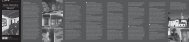
Piste ciclabili da scaricare - Tenero e valle Verzasca
Piste ciclabili da scaricare - Tenero e valle Verzasca
Piste ciclabili da scaricare - Tenero e valle Verzasca

You also want an ePaper? Increase the reach of your titles
YUMPU automatically turns print PDFs into web optimized ePapers that Google loves.
Robiei<br />
Poncione di Braga<br />
(2864 m s/m)<br />
P. di Röd<br />
(2699 m s/m)<br />
Mascarpino<br />
(2450 m s/m)<br />
2<br />
Fusio<br />
(1357 m s/m)<br />
Mogno<br />
Legen<strong>da</strong><br />
Percorsi – Strecken – Parcours – Routes<br />
Percorso 1<br />
Percorso 11<br />
Locarno - Cavergno Locarno - Valle Onsernone<br />
Lunghezza: 28,7 km Lunghezza: 26,3 km<br />
Dislivello: 257 m Dislivello: 904 m<br />
Percorso 2<br />
Percorso 12<br />
Ente Turistico – Verkehrsverein<br />
Office du Tourisme – Tourist Office<br />
Pronto soccorso – Erste Hilfe<br />
Premier secours – First aid<br />
Campeggio – Campingplatz<br />
Camping – Camping<br />
P. Castello<br />
(2808 m s/m)<br />
Bignasco - Fusio<br />
Lunghezza: 17 km<br />
Dislivello: 801 m<br />
Locarno - Cugnasco<br />
Lunghezza: 23 km<br />
Dislivello: 19 m<br />
Autopostale– Postauto<br />
Auto postale – Post bus<br />
Bus FART<br />
3<br />
S. Carlo (1016 m s/m)<br />
Robiei<br />
Piano di Peccia<br />
(1034 m s/m)<br />
Peccia<br />
Mogno<br />
Val Resa<br />
Percorso 3<br />
Bignasco - San Carlo<br />
Lunghezza: 11 km<br />
Dislivello: 570 m<br />
Percorso 13<br />
Riazzino - Monti Motti<br />
Lunghezza: 15 km<br />
Dislivello: 867 m<br />
FFS – SBB – CFF<br />
Navigazione Lago Maggiore<br />
Schifffahrtsgesellschaft<br />
Société de navigation<br />
Navigation society<br />
Valle Lavizzara<br />
Prato-Sornico<br />
Percorso 4<br />
Percorso 14<br />
Seggiovia – Sessellift<br />
Télésiège - Chair lift<br />
P. Rosso<br />
(2498 m s/m)<br />
2<br />
Locarno - Taglia Fuoco<br />
Lunghezza: 28 km<br />
Dislivello: 359 m<br />
Vira - Alpe di Neggia<br />
Lunghezza: 11,5 km<br />
Dislivello: 1187 m<br />
Funivia – Luftseilbahn<br />
Téléphérique - Cable car<br />
Chiesa – Kirche – Eglise – Church<br />
Bosco Gurin<br />
Bosco Gurin (1494 m s/m)<br />
10<br />
P. di Orsalia<br />
(2315 m s/m)<br />
P. Bombogn<br />
(2331 m s/m)<br />
Campo<br />
Valle di Bosco Gurin<br />
P. della Cazzana<br />
(2349 m s/m)<br />
P. della Rossa<br />
(2482 m s/m)<br />
Madone di Camedo<br />
(2446 m s/m)<br />
Ritorto<br />
Cerentino<br />
10<br />
Sabbione<br />
Fontana<br />
Valle Rovana<br />
Val Bavona<br />
3<br />
Linescio<br />
Valle di Campo<br />
Cevio<br />
P. Rosso<br />
15<br />
(2429 m s/m) Broglio (702 m s/m)<br />
MLago Maggiore<br />
Menzonio<br />
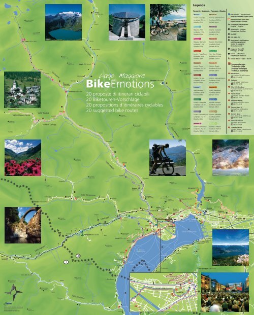
BikeEmotions<br />
Brontallo<br />
Sonogno (918 m s/m)<br />
18<br />
Cavergno<br />
(509 m s/m)<br />
20<br />
1<br />
3 2 Bignasco (456 m s/m)<br />
Riveo<br />
20 proposte di itinerari <strong>ciclabili</strong><br />
20 Biketouren-Vorschläge<br />
20 propositions d'itinéraires cyclables<br />
20 suggested bike routes<br />
Someo<br />
P. Muretto<br />
(2257 m s/m)<br />
Pne. Piancascia<br />
(2243 m s/m)<br />
Frasco<br />
Brione <strong>Verzasca</strong><br />
Valle <strong>Verzasca</strong><br />
P. di Mezzodi<br />
(2708 m s/m)<br />
Madom Gröss<br />
(2546 m s/m)<br />
P. Cramosino<br />
(2718 m s/m)<br />
Pne d’Alnasca<br />
(2301 m s/m)<br />
Percorso 5<br />
Losone - Porera<br />
Lunghezza: 10.2 km<br />
Dislivello: 605 m<br />
Percorso 6<br />
Locarno - Val Resa<br />
Lunghezza: 9,6 km<br />
Dislivello: 659 m<br />
Percorso 7<br />
Valle Cannobina<br />
Lunghezza: 68 km<br />
Dislivello: 699m<br />
Percorso 8<br />
Locarno - Palagnedra<br />
Lunghezza: 17,6 km<br />
Dislivello: 456 m<br />
Percorso 9<br />
Locarno - Forca di Dunzio<br />
Lunghezza: 17,3 km<br />
Dislivello: 426 m<br />
Percorso 10<br />
Locarno - Bosco Gurin<br />
Lunghezza: 39,2 km<br />
Dislivello: 1293 m<br />
Percorso 15<br />
Avegno – Broglio<br />
Lunghezza: 27,6 km<br />
Dislivello: 536 m<br />
Percorso 16<br />
Locarno - Salita dei Polacchi<br />
Lunghezza: 20 km<br />
Dislivello: 199 m<br />
Percorso 17<br />
<strong>Tenero</strong> - Mergoscia<br />
Lunghezza: 8,4 km<br />
Dislivello: 523 m<br />
Percorso 18<br />
Gordola - Sonogno<br />
Lunghezza: 25,2 km<br />
Dislivello: 385 m<br />
Percorso 19<br />
Locarno - Monte Brè<br />
Lunghezza: 10 km<br />
Dislivello: 814 m<br />
Percorso 20<br />
Locarno - Cavergno<br />
Lunghezza: 29,9 km<br />
Dislivello: 308 m<br />
1<br />
2<br />
3<br />
4<br />
5<br />
6<br />
7<br />
8<br />
9<br />
Soccorso tecnico<br />
Technische Hilfe<br />
Secours Technique<br />
Technical assistance<br />
Belotti Sport<br />
Via Cittadella 22, 6600 Locarno<br />
091 751 66 02<br />
Eratsport<br />
Via alle Brere 2, 6598 <strong>Tenero</strong><br />
091 745 10 79<br />
Bike-Cicli Chiandussi<br />
Via Circonvallazione 14, 6612 Ascona<br />
091 780 55 42<br />
Facchi Claudio<br />
Via Locarno 105, 6612 Ascona<br />
091 791 13 41<br />
Motocicli Widmer<br />
Via Mezzana 22, 6616 Losone<br />
091 791 40 35<br />
Ranzoni Moto SA<br />
Piazzale 5 Vie, 6600 Locarno<br />
091 751 29 55<br />
De Carli Mirto<br />
Via S. Gottardo 78, 6648 Minusio<br />
091 743 29 54<br />
Ghezzi Gianfranco<br />
Via Simen, 6600 Locarno<br />
091 751 80 09<br />
Jelmolini Silvano<br />
Piazza S. Antonio 6, 6600 Locarno<br />
091 751 66 60<br />
18<br />
Giumaglio<br />
Pne dei Laghetti<br />
(2440 m s/m)<br />
Coglio<br />
Madom <strong>da</strong> sgiòf<br />
(2265 m s/m)<br />
Sasso Bello<br />
(2290 m s/m)<br />
P. Cramalina<br />
(2322 m s/m)<br />
Valle Maggia<br />
10<br />
1<br />
20<br />
15<br />
Lavertezzo<br />
Punta di Spluga<br />
(2251 m s/m)<br />
Maggia<br />
P. di Corbella<br />
(2066 m s/m)<br />
P. di Vogorno<br />
(2442 m s/m)<br />
Valle Onsernone<br />
Pizzo Peloso<br />
(2064 m s/m)<br />
Aurigeno<br />
9<br />
Gordevio<br />
Monti Motti<br />
Corippo<br />
Lavertezzo<br />
Vergeletto<br />
Madone<br />
(2039 m s/m)<br />
Vogorno<br />
A. Saléi<br />
(1777 m s/m)<br />
Dunzio 9<br />
(627 m s/m)<br />
Mergoscia (733 m s/m)<br />
17<br />
Valle Onsernone<br />
Comologno<br />
Crana<br />
Russo<br />
Loco<br />
Auressio<br />
Mosogno<br />
Spruga (1105 m s/m) 11 11<br />
Cima di Caneto<br />
(1913 m s/m)<br />
P. Rusca<strong>da</strong><br />
(2004 m s/m)<br />
Comino<br />
Centovalli<br />
ISORNO<br />
Cavigliano<br />
8<br />
Golino 7<br />
Intragna<br />
Verscio<br />
11<br />
16<br />
Arcegno<br />
15<br />
Tegna<br />
5<br />
Avegno<br />
(316 m s/m)<br />
M. Brè<br />
(1015 m s/m)<br />
Ponte Brolla 19<br />
Via Tre Tetti<br />
11<br />
9<br />
Orselina<br />
10<br />
1<br />
20<br />
M. della Trinità<br />
Melezza<br />
5<br />
Losone<br />
5<br />
M. Verità<br />
FART<br />
8<br />
4<br />
Cimetta<br />
(1671 m s/m)<br />
Car<strong>da</strong><strong>da</strong><br />
(1496 m s/m)<br />
12<br />
Brione<br />
s./Minusio<br />
6<br />
Locarno<br />
(201 m s/m)<br />
Val Resa (860 m s/m)<br />
6<br />
7<br />
Rivapiana<br />
Contra<br />
17<br />
Minusio <strong>Tenero</strong><br />
(202 m s/m)<br />
17<br />
2<br />
<strong>Verzasca</strong><br />
Monti Motti<br />
(1067 m s/m)<br />
13<br />
18<br />
Gordola<br />
(226 m s/m)<br />
Monti di Ditto<br />
Aeroporto<br />
13<br />
Sassariente<br />
(1768 m s/m)<br />
Riazzino<br />
(200 m s/m)<br />
12<br />
13<br />
12<br />
Agarone<br />
Cugnasco<br />
(220 m s/m)<br />
Bellinzona<br />
Centovalli<br />
Domodossola<br />
Sempione CH<br />
Malesco<br />
Il Sassetto<br />
(1766 m s/m)<br />
7<br />
Valle Vigezzo<br />
Re<br />
I<br />
Camedo<br />
7<br />
CH<br />
8<br />
Palagnedra (657 m s/m)<br />
Ghiridone<br />
o M. Limi<strong>da</strong>rio<br />
(2188 m s/m)<br />
Rasa<br />
Pizzo Leone<br />
(1659 m s/m)<br />
Porera (830 m s/m)<br />
Via Valmara<br />
Via Barcone<br />
Cima della salita<br />
7<br />
Corona dei Pinci<br />
(1320 m s/m)<br />
4<br />
5<br />
Ronco<br />
s./Ascona<br />
Brissago<br />
Isole di<br />
Brissago<br />
7<br />
Ascona<br />
3<br />
Gerra<br />
Gambarogno<br />
S. Abbondio<br />
Maggia<br />
S. Nazzaro<br />
Piazzogna<br />
14<br />
Magadino<br />
Vira Gambarogno<br />
(208 m s/m)<br />
Fosano<br />
14<br />
Ticino<br />
14<br />
Alpe di Neggia (1395 m s/m)<br />
Gambarogno<br />
Quartino<br />
I<br />
Tamaro<br />
Lugano<br />
Milano<br />
Contone<br />
Bellinzona<br />
S. Gottardo<br />
S. Bernardino<br />
Caviano<br />
Testa del Mater<br />
(1846 m s/m)<br />
Questa è una cartina informativa e non sostituisce gli<br />
estratti di mappa del geometra e/o le cartine ufficiali.<br />
©Copyright: Geodes Sagl - www.geodes.ch<br />
Autorizzazione della SBC del x dicembre 2005<br />
Finero (900 m s/m)<br />
La Piota<br />
(1925 m s/m)<br />
Monte Colmine<br />
(1212 m s/m)<br />
Gurro<br />
Orasso<br />
Falmenta<br />
7<br />
PM. Zuccaro<br />
(1683 m s/m)<br />
Val Cannobina<br />
7<br />
S. Bartolomeo<br />
Verbania<br />
Cannobio<br />
FART<br />
11 10 9 1 20<br />
Via Bastoria<br />
4<br />
16<br />
7<br />
8<br />
4<br />
Via Locarno<br />
Tronzano<br />
Via Ferrera<br />
Via Delta<br />
Via Varenna<br />
Fiume Maggia<br />
Sesto Calende<br />
Via del Molino<br />
Solduno<br />
Solduno<br />
Via Pio<strong>da</strong><br />
Via Vallemaggia<br />
Via Varenna<br />
Via S. Jorio<br />
Via Nessi<br />
19<br />
Via Franzoni<br />
Via Bustelli<br />
4<br />
16 7<br />
6<br />
Via ai Monte della Trinità<br />
Via Rovedo<br />
6<br />
8<br />
Via Romerio<br />
Via Chiesa<br />
Locarno<br />
Indemini<br />
Chiesa Sant’Antonio<br />
9<br />
Via S. Jorio<br />
Via alla Peschiera<br />
6<br />
19<br />
20<br />
1<br />
9 1<br />
10<br />
11<br />
Via Cittadella<br />
Via Nessi<br />
Piazza<br />
Castello<br />
Via ai Saleggi<br />
Via Rusca<br />
7<br />
16<br />
4<br />
Via Orelli<br />
Via Bramantino<br />
Via Varesi<br />
Piazza<br />
Grande<br />
(201 m s/m)<br />
8<br />
Via Luini<br />
Via Franscini<br />
Via Ballerini<br />
Via Balestra<br />
Via Baroffio<br />
16<br />
7<br />
4<br />
Via Lavizzari<br />
Locarno<br />
Via Pedrazzini<br />
12<br />
Locarno, Piazza Grande
Numeri utili • Nützliche Nummern • Numéros utiles • Useful numbers<br />
144<br />
Emergenze, autoambulanze – Sanität-Notruf<br />
Ambulances, appel d'urgence – Ambulance emergency call<br />
Ospe<strong>da</strong>le La Carità<br />
Pronto Soccorso<br />
+41 (0)91 811 41 44<br />
1414<br />
REGA SOS elicottero<br />
Helikopter – Hélicoptère – Air rescue<br />
117<br />
118<br />
Polizia – Polizei – Police – Police<br />
Poliza cantonale +41 (0)91 816 10 11<br />
Polizia Comunale Locarno +41 (0)91 756 33 11<br />
Pompieri – Feuerwehr – Pompiers – Fire Brigade<br />
Centrale Locarno +41 (0)91 756 33 41<br />
140<br />
1811<br />
Clinica S. Chiara<br />
Pronto Soccorso<br />
+41 (0)91 756 41 44<br />
Soccorso stra<strong>da</strong>le – Strassenhilfe<br />
Secours routier – Breakdown service<br />
Informazioni – Auskünfte<br />
Renseignements – Information<br />
M<br />
Lago Maggiore<br />
BikeEmotions<br />
20 proposte di itinerari <strong>ciclabili</strong><br />
20 Biketouren-Vorschläge<br />
20 propositions d'itinéraires cyclables<br />
20 suggested bike routes<br />
145<br />
Intossicazione – Vergiftungen – Intoxication – Intoxication<br />
162<br />
Previsioni del tempo<br />
Wetterbericht<br />
Prévisions météorologiques<br />
Weather forecast<br />
Via B. Luini 3, CH-6600 Locarno<br />
Tel. +41 (0)91 791 00 91 – Fax +41 (0)91 785 19 41<br />
buongiorno@maggiore.ch – www.maggiore.ch<br />
Casella postale 124, CH-6601 Locarno<br />
veloclublocarno@ticino.com<br />
www.veloclublocarno.ch<br />
www.assos.com<br />
20 proposte di itinerari <strong>ciclabili</strong><br />
Paesaggi mozzafiato, un clima mite e temperato, itinerari pianeggianti o salite con<br />
oltre il 20% di dislivello, 2'300 ore di sole all’anno. È in questo splendido contesto<br />
che potrete pianificare gratificanti su<strong>da</strong>te in sella alla vostra inseparabile compagna:<br />
la bicicletta! Grazie all’incredibile vastità e diversità del nostro territorio, potrete<br />
pe<strong>da</strong>lare facilmente lungo le rive del Lago Maggiore e gli argini dei fiumi oppure<br />
sfacchinare per scalare le valli della nostra regione. Fornendo informazioni tecniche e<br />
turistiche, questa cartina vuole essere un valido supporto a tutti coloro che si<br />
cimenteranno, in modo professionale o solo per diletto, con la bicicletta. E allora,<br />
buona pe<strong>da</strong>lata!<br />
20 Biketouren-Vorschläge<br />
Eine atemberaubende Landschaft, ein mildes Klima, 2300 Stunden Sonnenschein<br />
im Jahr, flache Fahrradwege, aber auch Steigungen von über 20%. In diesem<br />
prächtigen Umfeld können Sie schönste schweisstreibende Touren auf ihrem unzertrennlichen<br />
Drahtesel planen. In dieser so weitläufigen und abwechslungsreichen<br />
Gegend kann man entlang des Seeufers oder der Flüsse locker in die Pe<strong>da</strong>le treten<br />
oder den Aufstieg in eines der Täler in Angriff nehmen. Mit ihren technischen und<br />
touristischen Informationen möchte diese Karte ein hilfreiches Instrument sein für<br />
alle, Profis und Amateure, die in unserer Gegend mit dem Fahrrad unterwegs sind.<br />
Also, auf in den Sattel und kräftig in die Pe<strong>da</strong>le getreten!<br />
20 propositions d'itinéraires cyclables<br />
Des paysages à couper le souffle, un climat doux et tempéré, des itinéraires au plat<br />
ou à la montée avec plus de 20 % de dénivellation, 2'300 heures d’ensoleillement<br />
annuel. C’est <strong>da</strong>ns ce splendide contexte que vous pourrez ressentir une saine et<br />
bonne fatigue grâce à votre inséparable compagne: la bicyclette. Vu l’incroyable<br />
étendue et la diversité de notre territoire, vous aurez le loisir de pé<strong>da</strong>ler sans effort<br />
le long des rives du Lago Maggiore et des berges de nos rivières ou alors peiner et<br />
découvrir les vallées de notre région. Cette carte sera certainement une mine<br />
d’informations techniques et touristiques utiles à tous les cyclistes assidus ou occasionnels<br />
qui enfourcheront leur bécane. Alors, bonne randonnée aux fervents de la<br />
petite reine!<br />
20 suggested bike routes<br />
Breathtaking landscapes, a soft and temperate climate, even routes or ascents, with<br />
are more than 20% uneven, and 2,300 hours of sunshine per year will accompany<br />
you during your sweat and satisfying trips on top of your inseparable bicycle. Thanks<br />
to the vastness and diversity of our territory, you will easily ride along the shore of<br />
Lago Maggiore and the banks, or you will toil to climb the <strong>valle</strong>ys of our region. This<br />
leaflet provides you with technical and tourist information and aims to support all<br />
those who will take an adventure, professionally or for delight, with a bicycle. Have<br />
a nice ride!<br />
Percorso 1<br />
Locarno - Cavergno<br />
Lunghezza: 28,7 km Dislivello: 257 m<br />
Percorso 2<br />
Bignasco - Fusio<br />
Lunghezza: 17 km<br />
Dislivello: 801 m<br />
Percorso 3<br />
Bignasco - San Carlo<br />
Lunghezza: 11 km Dislivello: 570 m<br />
Percorso 4<br />
Locarno - Taglia Fuoco<br />
Lunghezza: 28 km Dislivello: 359 m<br />
Percorso 5<br />
Losone - Porera<br />
Lunghezza: 10.2 km Dislivello: 605 m<br />
Percorso 6<br />
Locarno - Val Resa<br />
Lunghezza: 9,6 km Dislivello: 659 m<br />
Percorso 7<br />
Valle Cannobina<br />
Lunghezza: 68 km<br />
Dislivello: 699 m<br />
Percorso 8<br />
Locarno - Palagnedra<br />
Lunghezza: 17,6 km Dislivello: 456 m<br />
Percorso 9<br />
Locarno - Forca di Dunzio<br />
Lunghezza: 17,3 km Dislivello: 426 m<br />
Percorso 10<br />
Locarno - Bosco Gurin<br />
Lunghezza: 39,2 km Dislivello: 1293 m<br />
Percorso 11<br />
Locarno - Valle Onsernone<br />
Lunghezza: 26,3 km Dislivello: 904 m<br />
Percorso 12<br />
Locarno - Cugnasco<br />
Lunghezza: 23 km<br />
Dislivello: 19 m<br />
Percorso 13<br />
Riazzino - Monti Motti<br />
Lunghezza: 15 km Dislivello: 867 m<br />
Percorso 14<br />
Vira - Alpe di Neggia<br />
Lunghezza: 11,5 km Dislivello: 1187 m<br />
Percorso 15<br />
Avegno - Broglio<br />
Lunghezza: 27,6 km Dislivello: 536 m<br />
Percorso 16<br />
Locarno - Salita dei Polacchi<br />
Lunghezza: 20 km Dislivello: 199 m<br />
Percorso 17<br />
<strong>Tenero</strong> - Mergoscia<br />
Lunghezza: 8,4 km Dislivello: 523 m<br />
Percorso 18<br />
Gordola - Sonogno<br />
Lunghezza: 25,2 km Dislivello: 385 m<br />
Percorso 19<br />
Locarno - Monte Brè<br />
Lunghezza: 10 km Dislivello: 814 m<br />
Percorso 20<br />
Locarno - Cavergno<br />
Lunghezza: 29,9 km Dislivello: 308 m<br />
1 Locarno-Cavergno<br />
Da Piazza Grande ci si dirige verso Ponte Brolla, dove si svolta a destra per la Vallemaggia. Seguendo la stra<strong>da</strong> carrabile si giunge a<br />
Bignasco. In alcuni tratti è presente una pista ciclabile.<br />
Von der Piazza Grande fährt man Richtung Ponte Brolla und biegt dort rechts ins Maggiatal ab. Der Fahrtrasse entlang erreicht<br />
man Bignasco. Einige Abschnitte verfügen über einen Fahrradweg.<br />
De la Piazza Grande se diriger vers Ponte Brolla. Au passage à niveau tourner à droite pour entrer <strong>da</strong>ns le Val Maggia. Suivre la<br />
route principale jusqu’à Bignasco. Il existe une piste cyclable sur certains tronçons.<br />
From Piazza Grande follow in the direction of Ponte Brolla, where you turn right in the direction of Vallemaggia. The cart track<br />
leads to Bignasco. Along the way there are some cycle tracks.<br />
2 Bignasco-Fusio<br />
A Bignasco svoltando a destra, ci si addentra nella Val Lavizzara. Salendo per circa 17 Km sulla stra<strong>da</strong> carrabile si raggiunge la<br />
splendi<strong>da</strong> Fusio, ai piedi della diga del Sambuco.<br />
In Bignasco geht es rechts ins Lavizzaratal. Nach einer Steigung von etwa 17 km erreicht man den wunderschönen Ort Fusio, am<br />
Fusse der Sambuco-Staumauer gelegen.<br />
A Bignasco tourner à droite pour s’engager <strong>da</strong>ns le Val Lavizzara. Après environ 17 km de montée, on arrive <strong>da</strong>ns le splendide<br />
village, Fusio, au pied du barrage de Sambuco.<br />
In Bignasco turn right and enter Val Lavizzara. Climb the 17 Km cart track and reach Fusio, a wonderful village under the<br />
Sambuco <strong>da</strong>m.<br />
m s/m<br />
700<br />
600<br />
600<br />
Brontallo<br />
Broglio<br />
Prato Sornico<br />
500<br />
Cavergno<br />
500<br />
400<br />
Gordevio<br />
Coglio Someo<br />
Bignasco<br />
400<br />
Avegno<br />
Riveo<br />
Cevio<br />
300<br />
Maggia<br />
300<br />
Giumaglio<br />
200<br />
Ponte Brolla<br />
200<br />
100<br />
Locarno<br />
Piazza Grande<br />
100<br />
0<br />
0<br />
km 0 5 10 15 20 25 30 km 28.7 30 35 40 45<br />
m s/m<br />
1400<br />
1300<br />
1200<br />
1100<br />
1000<br />
900<br />
800<br />
Menzonio<br />
Peccia<br />
Fusio<br />
km<br />
3 Bignasco - San Carlo<br />
A Bignasco, svoltando a sinistra, ci si addentra nella pittoresca Val Bavona. Dopo una salita di circa 11 Km la stra<strong>da</strong> termina a San<br />
Carlo, <strong>da</strong> dove parte la funivia per Robiei.<br />
In Bignasco geht es links in <strong>da</strong>s pittoreske Bavonatal. Nach etwa 11 ansteigenden Kilometern endet die Strasse in San Carlo, von<br />
wo eine Seilbahn nach Robiei führt.<br />
A Bignasco tourner à gauche pour découvrir une pittoresque petite vallée, le Val Bavona. Après une montée d’environ 11 km la<br />
route se termine à San Carlo d’où part le téléphérique pour Robiei.<br />
In Bignasco turn left and enter the picturesque Val Bavona. After an ascent of about 11 Km the street ends in San Carlo, where<br />
you can take the cable-car to Robiei.<br />
m s/m<br />
1100<br />
1000<br />
900<br />
800<br />
700<br />
600<br />
500<br />
400<br />
300<br />
200<br />
100<br />
0<br />
Bignasco<br />
Fontana<br />
Sabbione<br />
Ritorto<br />
28.7 30 35 40<br />
San Carlo<br />
km<br />
4 Locarno-Taglia Fuoco<br />
Da Locarno seguire direzione Brissago percorrendo la trafficata stra<strong>da</strong> che costeggia il Lago Maggiore. Alla posta di Brissago salire<br />
a destra e poi sempre a destra seguire la stra<strong>da</strong> pianeggiante di Via Barcone. Al Monte Verità ridiscendere verso Ascona e poi<br />
ritornare verso Locarno.<br />
Von Locarno erreicht man über die verkehrsreiche Seestrasse Brissago. Bei der Post von Brissago geht es rechts bergauf bis zur Via<br />
Barcone, die nach Ronco s/Ascona führt. Von dort geht es Richtung Monte Verità und hinunter nach Ascona und weiter zurück<br />
nach Locarno.<br />
De Locarno suivre la direction Brissago en empruntant la route très fréquentée qui suit le bord du Lac Majeur. A la poste de<br />
Brissago monter à droite et suivre, toujours à droite, à flanc de coteau, la route de Via Barcone. Au Monte Verità redescendre sur<br />
Ascona et repartir vers Locarno.<br />
From Locarno ride in the direction of Brissago following the carriage way along the shore of Lago Maggiore. At Posta di Brissago<br />
(Post Office of Brissago) climb right and then turn right to follow Via Barcone. In Monte Verità descend in the direction of Ascona<br />
and return to Locarno.<br />
m s/m<br />
600<br />
500<br />
400<br />
300<br />
200<br />
100<br />
0<br />
Ascona<br />
mt. Verità<br />
Ascona<br />
salita mt. Verità<br />
Locarno<br />
Piazza Grande<br />
Cima della salita<br />
Inizio salita<br />
via Barcone<br />
Brissago<br />
Via Valmara<br />
Ascona<br />
Locarno<br />
Piazza Grande<br />
0 5 10 15 20 25 30<br />
5 Losone - Porera<br />
6 Locarno - Val Resa<br />
7<br />
Valle Cannobina<br />
8 Locarno - Palagnedra<br />
Da Losone bisogna salire in direzione di Arcegno. Seguire la stra<strong>da</strong> pianeggiante in direzione di Ronco s/Ascona per poi salire in<br />
direzione di Porera/Monti di Ronco s/Ascona.<br />
Ab Losone geht es hinauf nach Arcegno. Von dort führt die nun wieder flachere Strasse nach Ronco s/Ascona. Bei Cappella<br />
Gruppaldo biegt rechts die steile Strasse nach Porera/Monti di Ronco s/Ascona ab.<br />
De Losone monter en direction d’Arcegno. Suivre ensuite la route, à flanc de coteau, en direction de Ronco sopra Ascona puis<br />
monter en direction de Porera/Monti de Ronco s/Ascona.<br />
From Losone climb in the direction of Arcegno. Follow the flat street in the direction of Ronco s/Ascona and climb to Porera/Monti<br />
di Ronco s/Ascona.<br />
Da Locarno salire in direzione Locarno Monti <strong>da</strong> dove si svolterà a destra direzione Orselina, Brione s/Minusio e Contra. Prima di<br />
Contra svoltare a sinistra e salire in direzione Val Resa<br />
Von Locarno geht es in Richtung Locarno Monti und von dort rechts weiter in Richtung Orselina, Brione s/Minusio und Contra.<br />
Kurz vor Contra schwenkt die Strasse links ins Val Resa ein.<br />
De Locarno monter à Locarno Monti. Là, tourner à droite vers Orselina, Brione sopra Minusio et Contra. Avant d’arriver à Contra<br />
tourner à gauche et monter en direction du Val Resa.<br />
From Locarno climb in the direction of Locarno Monti, where you turn right to Orselina, Brione s/Minusio and Contra. Before<br />
Contra turn left and climb in the direction of Val Resa.<br />
Da Locarno seguire direzione Brissago percorrendo la trafficata stra<strong>da</strong> che costeggia il Lago Maggiore fino a Cannobio (I), svoltare<br />
a destra direzione Val Cannobina fino a Malesco. Ritornare attraverso la Val Vigezzo e le Centovalli.<br />
Von Locarno geht es auf der vielbefahrenen Seestrasse nach Brissago und über die Grenze weiter nach Canobbio (I). Nach der<br />
Kirche geht es rechts ins Cannobinatal bis nach Malesco. Rückweg durch <strong>da</strong>s Vigezzotal und die Centovalli.nnobina fino a<br />
Malesco. Ritornare attraverso la Val Vigezzo e le Centovalli.<br />
De Locarno suivre la direction Brissago en empruntant la route très fréquentée qui suit le bord du Lac Majeur jusqu’à Cannobio (I),<br />
tourner à droite direction Val Cannobina jusqu’à Malesco. Rentrer par le Val Vigezzo et les Centovalli.<br />
From Locarno ride in the direction of Brissago following the carriage way along the shore of Lago Maggiore until Cannobio (Italy).<br />
Once there turn right in the direction of Val Cannobina and follow the road until Malesco. You can go back through Val Vigezzo<br />
and Centovalli.<br />
Da Locarno dirigersi verso la caserma di Losone passando per Via Vallemaggia, le rotonde di Solduno e Losone e Via Locarno.<br />
Proseguire in direzione di Camedo. All’altezza del lago artificiale, svoltare a sinistra e salire fino a Palagnedra.<br />
Von Locarno geht es Richtung Kaserne Losone über Via Vallemaggia, die Kreisel von Solduno und Losone und Via Locarno.<br />
Danach weiter über Golino und Intragna in Richtung Camedo. Auf Höhe des Stausees links hinauf nach Palagnedra.<br />
De Locarno se diriger vers la caserne de Losone en passant par la route Via Vallemaggia, les giratoires de Solduno, Losone et Via<br />
Locarno. Continuer en direction de Camedo. A la hauteur du lac artificiel tourner à gauche et monter jusqu’à Palagnedra.<br />
From Locarno follow in the direction of Caserma di Losone (Losone Military Barrack) riding along Via Vallemaggia . Pass the<br />
roun<strong>da</strong>bouts of Solduno and Losone, ride along Via Locarno and continue in the direction of Camedo. Once you have reached the<br />
<strong>da</strong>m turn left and climb until Palagnedra.<br />
m s/m<br />
m s/m<br />
900<br />
800<br />
700<br />
600<br />
Porera<br />
m s/m<br />
900<br />
800<br />
700<br />
600<br />
Val Resa<br />
1000<br />
900<br />
800<br />
700<br />
600<br />
Finero<br />
Malesco<br />
Re<br />
Camedo CH/I<br />
m s/m<br />
700<br />
600<br />
Palagnedra<br />
500<br />
400<br />
Arcegno<br />
500<br />
400<br />
Orselina<br />
Brione s/minusio<br />
500<br />
400<br />
500<br />
400<br />
300<br />
200<br />
100<br />
0<br />
km<br />
Losone<br />
Ronco s/Ascona<br />
incrocio<br />
0 5 10<br />
300<br />
200<br />
100<br />
0<br />
km<br />
Locarno<br />
Piazza Grande<br />
0 5 10<br />
300<br />
200<br />
100<br />
0<br />
km<br />
Ascona<br />
Locarno<br />
Piazza Grande<br />
Brissago<br />
Cannobio<br />
Intragna<br />
Golino<br />
Losone<br />
Locarno<br />
Piazza Grande<br />
0 5 10 15 20 25 30 35 40 45 50 55 60 65 70<br />
300<br />
200<br />
100<br />
0<br />
km<br />
Locarno<br />
Piazza Grande<br />
Losone<br />
Golino<br />
Intragna<br />
0 5 10 15 20<br />
9 Locarno - Aurigeno - Forca di Dunzio<br />
10 Locarno - Bosco Gurin<br />
11 Locarno - Valle Onsernone<br />
12 Locarno - Cugnasco - Locarno<br />
Da Piazza Grande ci si dirige verso Ponte Brolla, dove si svolta a destra per la Vallemaggia. Seguire la stra<strong>da</strong> carrabile fino ad<br />
Aurigeno, svoltare a sinistra per salire fino alla Forca di Dunzio.<br />
Von der Piazza Grande geht es nach Ponte Brolla, wo man rechts ins Maggiatal abbiegt. In Aurigeno führt links eine Strasse nach<br />
Forca di Dunzio hinauf.<br />
De la Piazza Grande se diriger vers Ponte Brolla, tourner à droite <strong>da</strong>ns le Val Maggia et suivre la route principale jusqu’à Aurigeno.<br />
Là, tourner à gauche pour monter jusqu’à la Forca di Dunzio.<br />
From Piazza Grande (Locarno) ride in direction of Ponte Brolla. Once there turn right to Vallemaggia. Follow the cart track until<br />
Aurigeno and turn left to climb until Forca di Dunzio.<br />
Da Piazza Grande ci si dirige verso Ponte Brolla, dove si svolta a destra per la Vallemaggia. Seguendo la stra<strong>da</strong> carrabile si giunge a<br />
Cevio. Svoltare a sinistra entrando in Val Rovana. La stra<strong>da</strong> termina a Bosco Gurin.<br />
Von der Piazza Grande geht es nach Ponte Brolla, von dort rechts ins Maggiatal und auf der Autostrasse weiter bis Cevio, wo man<br />
links ins Val Rovana einbiegt. Die Strasse endet in Bosco Gurin.<br />
De la Piazza Grande se diriger vers Ponte Brolla, tourner à droite <strong>da</strong>ns le Val Maggia et suivre la route principale jusqu’à Cevio.<br />
Bifurquer à gauche pour entrer <strong>da</strong>ns le Val Rovana. La route s’arrête à Bosco Gurin.<br />
From Piazza Grande (Locarno) ride in the direction of Ponte Brolla. Once there turn right and ride through Vallemaggia. Follow the<br />
cart track until Cevio and turn left to enter Val Rovana. The street ends in Bosco Gurin.<br />
m s/m<br />
1400<br />
Bosco Gurin<br />
Da Locarno dirigersi verso Ponte Brolla, dove si svolterà a sinistra direzione Centovalli/Onsernone. A Cavigliano salire a destra per<br />
entrare in Val Onsernone. La stra<strong>da</strong> termina a Spruga.<br />
Von Locarno geht es nach Ponte Brolla, wo es links in Richtung Centovalli/Onsernone weitergeht. In Cavigliano rechts bergauf ins<br />
Onsernonetal fahren. Die Strasse endet in Spruga.<br />
De Locarno se diriger vers ponte Brolla ; là, tourner à gauche direction Centovalli/Onsernone. A Cavigliano monter à droite pour<br />
entrer <strong>da</strong>ns le Val Onsernone. La route s’arrête à Spruga.<br />
From Locarno ride to Ponte Brolla, where you turn left in direction of Centovalli/Onsernone. In Cavigliano climb right to enter Val<br />
Onsernone. The street ends in Spruga.<br />
m s/m<br />
Da Locarno dirigersi in direzione di Cugnasco seguendo la stra<strong>da</strong> pedonale/ciclabile di Via alla Riva a Minusio. A <strong>Tenero</strong> imboccare<br />
la pista ciclabile numero 3 che passa sul Piano di Magadino.<br />
Von Locarno geht es in Richtung Cugnasco über den Fahrrad- und Fussweg Via alla Riva in Minusio. In <strong>Tenero</strong> beginnt der<br />
Fahrradweg Nr.3, der über die Magadino-Ebene führt.<br />
De Locarno se diriger vers Cugnasco en suivant la route piétonne/cyclable de Via alla Riva à Minusio. A <strong>Tenero</strong> s’engager sur la<br />
piste cyclable no 3 qui traverse La Plaine de Magadino.<br />
From Locarno ride in the direction of Cugnasco following the cycle and pedestrian path of Via alla Riva in Minusio. In <strong>Tenero</strong> ride<br />
along the cycle track nr. 3, which goes on through Piano di Magadino.<br />
1300<br />
1300<br />
1200<br />
1100<br />
1200<br />
1100<br />
Spruga<br />
1000<br />
900<br />
800<br />
Cerentino<br />
1000<br />
900<br />
800<br />
Mosogno<br />
Crana<br />
Comologno<br />
m s/m<br />
km<br />
600<br />
500<br />
400<br />
300<br />
200<br />
100<br />
0<br />
Locarno<br />
Piazza Grande<br />
Ponte Brolla<br />
Avegno<br />
Gordevio<br />
Aurigeno<br />
Dunzio<br />
0 5 10 15 20<br />
km<br />
700<br />
600<br />
500<br />
400<br />
300<br />
200<br />
100<br />
0<br />
Avegno<br />
Ponte Brolla<br />
Locarno<br />
Piazza Grande<br />
Gordevio<br />
Maggia<br />
Coglio<br />
Someo<br />
Giumaglio<br />
0 5 10 15 20 25 30 35 40<br />
Riveo<br />
Cevio<br />
Linescio<br />
km<br />
700<br />
600<br />
500<br />
400<br />
300<br />
200<br />
100<br />
0<br />
Tegna<br />
Ponte Brolla<br />
Locarno<br />
Piazza Grande<br />
Verscio<br />
Cavigliano<br />
Auressio<br />
Loco<br />
0 5 10 15 20 25 30<br />
Russo<br />
m s/m<br />
km<br />
400<br />
300<br />
200<br />
100<br />
0<br />
Rivapiana<br />
Locarno<br />
Piazza Grande<br />
Campeggi<br />
<strong>Tenero</strong><br />
<strong>Tenero</strong><br />
Centro Sportivo<br />
Aeroporto<br />
Cugnasco<br />
Aeroporto<br />
<strong>Tenero</strong><br />
Centro Sportivo<br />
Campeggi<br />
<strong>Tenero</strong><br />
Rivapiana<br />
Locarno<br />
Piazza Grande<br />
0 5 10 15 20 25<br />
13 Riazzino - Monti Motti<br />
14 Vira Gambarogno - Alpe di Neggia<br />
15 Avegno - Broglio<br />
16 Locarno - Salita dei polacchi<br />
A Riazzino, in prossimità delle scuole comunali, sale la stra<strong>da</strong> che raggiunge i Monti Motti. Dopo circa 15 Km di salita intercalata a<br />
falsipiani, la stra<strong>da</strong> termina. Degna di nota la vista panoramica sul Lago Maggiore.<br />
In Riazzino beginnt in der Nähe des Schulgebäudes die Strasse nach Monti Motti. Die teils steile, teils ebene Strasse endet nach<br />
etwa 15 km und bietet eine bemerkenswerte Aussicht auf den Lago Maggiore.<br />
A Riazzino, près des écoles communales, prendre la route qui monte aux Monti Motti. Après environ 15 km de montées et de<br />
faux plats la route s’arrête. Superbe vue panoramique sur le Lac Majeur.<br />
In Riazzino, near Scuole Municipali (Municipal Schools), climb the street which leads to Monti Motti. The street ends after an<br />
uneven ascent of about 15 Km. When there enjoy a wonderful view of Lago Maggiore.<br />
m s/m<br />
1200<br />
1100<br />
Monti<br />
Motti<br />
Da Vira Gambarogno si sale in direzione di Fosano dove, svoltando a sinistra ci si dirige in direzione di Indemini. L’impegnativa<br />
salita vi porterà sino all’Alpe di Neggia.<br />
Von Vira Gambarogno steigt man nach Fosano hinauf, wo es rechts in Richtung Indemini weitergeht und über eine anspruchsvolle<br />
Bergstrasse bis hinauf zur Alpe di Neggia.<br />
De Vira Gambarogno monter en direction de Fosano puis tourner à gauche en direction d’Indemini. Une route en lacets monte<br />
jusqu’à l’alpage de Neggia.<br />
From Vira Gambarogno climb in the direction of Fosano. Once there turn left and ride to Indemini. The difficult ascent will lead<br />
you to Alpe di Neggia.<br />
m s/m<br />
1400<br />
1300<br />
1200<br />
1100<br />
Alpe di Neggia<br />
Da Avegno seguire la stra<strong>da</strong> carrabile sino a Bignasco dove, svoltando a destra si entra in Val Lavizzara. Proseguire sulla stra<strong>da</strong><br />
principale e poi svoltare a sinistra per salire fino ai 702 metri di Broglio.<br />
Von Avegno folgt man der Autostrasse bis Bignasco, wo sie rechts ins Lavizzaratal einmündet . Nach einer Weile biegt man von<br />
der Hauptstrasse links ab und nimmt die steile Strasse in Angriff, die auf die 702 Höhenmeter von Broglio führt.<br />
Depuis Avegno suivre la route principale jusqu’à Bignasco. Prendre à droite la route du Val Lavizzara jusqu’à la bifurcation sur la<br />
gauche pour Broglio, village située à 702 m d’altitude.<br />
From Avegno ride along the cart track until Bignasco, then turn right and enter Val Lavizzara. Follow the main street, turn left and<br />
climb until Broglio (702m).<br />
Da Locarno dirigersi verso il Monte Verità sopra Ascona passando per il ponte nuovo e il Lungolago Motta. Svoltare a sinistra verso<br />
Ronco e poi a destra per salire verso Arcegno. Oltrepassato il nucleo e il Campo Pestalozzi scendere verso Golino, svoltare a destra<br />
verso Losone e tornare a Locarno. (Si può fare anche al contrario)<br />
Von Locarno geht es über die neue Maggiabrücke und den Lungolago Motta zum Monte Verità oberhalb von Ascona. Dort links<br />
Richtung Ronco s/Ascona einschwenken und <strong>da</strong>nn rechts nach Arcegno hinauffahren, wo es durch den Dorfkern und am Campo<br />
Pestalozzi vorbei hinunter nach Golino geht und schliesslich rechts via Losone zurück nach Locarno. (Auch umgekehrt möglich)<br />
Depuis Locarno se diriger vers le Monte Verità au dessus d’Ascona en passant par le nouveau pont et le bord du lac (lungolago<br />
Motta).Tourner à gauche vers Ronco puis à droite pour monter vers Arcegno. Une fois dépassé le centre du village et le Centre<br />
Pestalozzi, descendre vers Golino, tourner à droite vers Losone et revenir vers Locarno. (Ce parcours peut-être fait aussi en sens<br />
inverse.<br />
From Locarno ride in the direction of Monte Verità (on top of Ascona), crossing the new bridge and riding along Lungo Lago<br />
Motta. Turn left in the direction of Ronco and then right to climb to Arcegno. After the nucleus and Campo Pestalozzi descend to<br />
Golino, turn right to Losone and go back to Locarno. (You can also the opposite way).<br />
1000<br />
900<br />
800<br />
Monti di Ditto<br />
1000<br />
900<br />
800<br />
m s/m<br />
900<br />
800<br />
Brontallo<br />
Menzonio<br />
700<br />
600<br />
700<br />
600<br />
700<br />
600<br />
Broglio<br />
m s/m<br />
km<br />
500<br />
400<br />
300<br />
200<br />
100<br />
0<br />
Riazzino<br />
Agarone<br />
0 5 10 15<br />
km<br />
500<br />
400<br />
300<br />
200<br />
100<br />
0<br />
Vira Gambarogno<br />
Fosano<br />
0 5 10<br />
km<br />
500<br />
400<br />
300<br />
200<br />
100<br />
0<br />
Avegno<br />
Gordevio<br />
Maggia<br />
Coglio<br />
Giumaglio<br />
Someo<br />
Riveo<br />
0 5 10 15 20 25 30<br />
Cevio<br />
Bignasco<br />
km<br />
500<br />
400<br />
300<br />
200<br />
100<br />
0<br />
Locarno<br />
Piazza Grande<br />
Losone<br />
Salita dei polacchi<br />
Arcegno<br />
Ronco s/Ascona<br />
Monte Verità<br />
Ascona<br />
Locarno<br />
Piazza Grande<br />
0 5 10 15 20<br />
17 <strong>Tenero</strong> - Mergoscia<br />
18 Valle <strong>Verzasca</strong><br />
19 Locarno - Monte Brè<br />
20 Locarno - Cavergno<br />
Dalla roton<strong>da</strong> di <strong>Tenero</strong> prendere la stra<strong>da</strong> che sale verso Contra e Mergoscia. Dopo circa 8.5 Km, la stra<strong>da</strong> carrabile termina nel<br />
suggestivo villaggio di Mergoscia.<br />
Beim Kreisel in <strong>Tenero</strong> die Bergstrasse nach Contra und Mergoscia einschlagen. Nach etwa 8,5 Km endet die Strasse in diesem<br />
malerischen kleinen Dorf.<br />
Du giratoire de <strong>Tenero</strong> prendre la route qui monte vers Contra et Mergoscia. Après environ 8,5 km la route s’arrête <strong>da</strong>ns le très<br />
beau village de Mergoscia.<br />
From the roun<strong>da</strong>bout of <strong>Tenero</strong> follow the street to Contra and Mergoscia. The cart track ends in Mergoscia, after about 8,5 Km.<br />
Dal centro di Gordola prendere la stra<strong>da</strong> che sale verso la Val <strong>Verzasca</strong>. Dopo circa 25 Km di salite intercalate a falsipiani, la stra<strong>da</strong><br />
carrabile termina nel nucleo di Sonogno.<br />
Vom Zentrum von Gordola führt eine Strasse hinauf ins <strong>Verzasca</strong>tal. Nach ca. 25 km endet die teils steile, teils ebene Strasse im<br />
Dorfkern von Sonogno.<br />
Du centre de Gordola prendre la route qui monte vers le Val <strong>Verzasca</strong>. Après environ 25 km de montées et de faux plats la route<br />
principale s’arrête au centre du village de Sonogno.<br />
From the centre of Gordola follow the street which climbs in the direction of Valle <strong>Verzasca</strong>. After 25 km of uneven ascents, the<br />
cart track ends in the nucleus of Sonogno,.<br />
Da Piazza Grande dirigersi verso la Piazza Sant’Antonio in Città Vecchia <strong>da</strong> dove parte l’impegnativa salita verso Locarno Monti.<br />
Svoltare a sinistra e salire fino a Monte Brè.<br />
Von der Piazza Grande geht es zur Piazza Sant‘Antonio in der Altstadt, wo die anspruchsvolle Strasse nach Locarno Monti<br />
beginnt. Auf der Höhe geht es links weiter bis hinauf auf den Monte Bré.<br />
De la Piazza Grande prendre la direction de la Piazza Sant’Antonio <strong>da</strong>ns la vieille ville d’où part une route en pente raide vers<br />
Locarno-Monti. Tourner à gaucher et monter jusqu’au Monte Brè.<br />
From Piazza Grande (Locarno) ride to Piazza Sant’Antonio (Città Vecchia) and follow the difficult ascent to Locarno Monti. Turn<br />
left and climb until Monte Brè.<br />
Da Piazza Grande ci si dirige verso Ponte Brolla, dove si svolta a destra per la Vallemaggia. Seguendo la stra<strong>da</strong> carrabile si giunge a<br />
Cavergno. In alcuni tratti è presente una pista ciclabile.<br />
Von der Piazza Grande geht es nach Ponte Brolla und dort rechts ins Maggiatal hinein bis Cavergno. Einige Abschnitte verfügen<br />
über einen Fahrradweg.<br />
De la Piazza Grande se diriger vers Ponte Brolla, tourner à droite <strong>da</strong>ns le Val Maggia et suivre la route principale jusqu’à Cavergno.<br />
Il existe une piste cyclable sur certains tronçons.<br />
From Piazza Grande (Locarno) ride in the direction of Ponte Brolla and turn right to Vallemaggia. Follow the cart track and reach<br />
Cavergno. Along the way there is sometimes a cycle track.<br />
m s/m<br />
m s/m<br />
m s/m<br />
1000<br />
900<br />
Frasco<br />
Sonogno<br />
1100<br />
1000<br />
900<br />
Monte Brè<br />
800<br />
700<br />
600<br />
500<br />
400<br />
300<br />
200<br />
100<br />
0<br />
km<br />
Mergoscia<br />
Contra<br />
<strong>Tenero</strong> roton<strong>da</strong><br />
0 5 10<br />
800<br />
700<br />
600<br />
500<br />
400<br />
300<br />
200<br />
100<br />
0<br />
km<br />
Brione <strong>Verzasca</strong><br />
Vogorno<br />
Gordola<br />
0 5 10 15 20 25 30<br />
800<br />
700<br />
600<br />
500<br />
400<br />
300<br />
200<br />
100<br />
0<br />
km<br />
Chiesa<br />
Sant’Antonio<br />
Locarno<br />
Piazza Grande<br />
Monti Trinità<br />
Via Tre Tetti<br />
0 5 10<br />
m s/m<br />
600<br />
500<br />
400<br />
300<br />
200<br />
100<br />
0<br />
km<br />
Ponte Brolla<br />
Locarno<br />
Piazza Grande<br />
Avegno<br />
Gordevio<br />
Maggia<br />
0 5 10 15 20 25 30<br />
Coglio<br />
Giumaglio<br />
Someo<br />
Riveo<br />
Cevio<br />
Cavergno<br />
Bignasco