
Create successful ePaper yourself
Turn your PDF publications into a flip-book with our unique Google optimized e-Paper software.
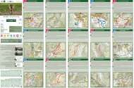
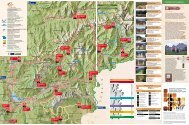
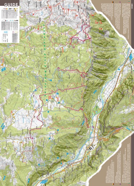
Bus<br />
Forcella / Small mountain pass<br />
Arrampicata / Climbing Rocks<br />
Traccia di sentiero / Trail<br />
GUIDE<br />
TO SYMBOLS<br />
Grotta / Cave<br />
Sentiero ben evidente / Well-rendered path<br />
Bivacco, baito, ricovero / Bivouac, shelter<br />
Sentiero SAT segnalato / Signed path<br />
Punto panoramico / Panoramic point<br />
Fontana / Fountain<br />
Scala: 1:25.000<br />
Scale<br />
Equidistanza: 50mt<br />
Equidistance<br />
Realizzazione: 2011<br />
Realization<br />
Disegno: pradelm@gmail.com<br />
Parcheggio / Parking<br />
Confine provinciale/ Provincial border<br />
Parco giochi / Playground<br />
Confine comunale / Municipal border<br />
Capitello / Tiny Church<br />
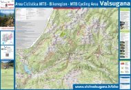
Ciclabile della <strong>Valsugana</strong><br />
<strong>Valsugana</strong> cycling path<br />
Croce / Cross<br />
Chiesa,cimitero / Church, cemetery<br />
Percorsi ciclabili consigliati<br />
Suggested cycling routes<br />
Trekking consigliato / Recommended trekking<br />
Area di Picnic / Picnic area<br />
Campeggio / Camping<br />
Divieto di transito / No thoroughfare<br />
Malga / Cheese Farm<br />
Campo sportivo / Sport Facilities<br />
Strada bianca / Country road<br />
Albergo, garnì, rifugio, B&B<br />
Hotel, garnì, mountain refuge<br />
Bancomat / Cash Machine<br />
Strada asfaltata / Asphalt road<br />
Stazione treni / Railway Station<br />
Curve livello / Contour line<br />
Einwohner: 2.340. Höhe: 263m ü.d.M.<br />
Der Sommerferienort Grigno ist für diejenigen,<br />
die aus Richtung Bassano kommen und<br />
in Richtung Trento fahren, der erste<br />
Ort des <strong>Valsugana</strong>. Seine Umgebung<br />
ist aufgrund von vielzähligen Naturhöhlen,<br />
einige von bedeutenden<br />
Ausmaßen, aus speleologischen<br />
Gesichtspunkten sehr<br />
interessant. Hier kann man<br />
wohltuende und erholsame<br />
Spazieränge in der<br />
Natur machen.<br />
Inhabitants: 2.340. Altitude: 263 m<br />
Grigno is the first hamlet in <strong>Valsugana</strong> for those coming from Bassano in<br />
the direction of Trento. It is an ideal place for summer breaks, but also a<br />
thriving industrial centre. Its surroundings are particularly interesting for<br />
speleology thanks to the abundance of natural caves, some of which<br />
are of considerable size. Anywhere near it is possible to take<br />
stroll in a peaceful natural environment.<br />
Abitanti: 2.340. Altitudine: 263 m<br />
Grigno è il primo borgo della <strong>Valsugana</strong> per chi proviene da Bassano, in direzione<br />
Trento. Centro di soggiorno estivo, vi prospera l´industria.<br />
La zona attorno al paese riveste un notevole interesse speleologico,<br />
data l’abbondanza di cavità naturali, alcune delle quali di ragguardevoli<br />
dimensioni. I dintorni offrono buone possibilità per salubri passeggiate<br />
in un sereno ambiente naturale.<br />
GRIGNO<br />
Il posto dove ho sempre vissuto è la mia camera interiore, lo spazio fisico della Valle è<br />
ristretto al minimo, ma questo aiuta a concentrarmi sul variegato mondo infinitesimale<br />
(compreso quello dei sentimenti) che mi circonda.<br />
A volte mi manca il vasto orizzonte... ma è sempre con grande quiete che ritorno<br />
(pregustandolo con gli occhi) al mio spazio delimitato dai monti.<br />
“Orlando Gasperini”<br />
The place where I have always lived is my inner room, the physical space of the Valley<br />
is restricted to the minimum, but this helps me concentrate on the infinitely varied<br />
world (including feelings) that surrounds me. Sometimes I miss the vast horizon…<br />
but I always come back with great calm (foretasting it with the eyes) to my<br />
space bordered by mountains.<br />
“Orlando Gasperini”<br />
Der Ort, an dem ich immer gelebt habe, istmein Innenraum,<br />
der natürliche Raum des Tals auf ein Minimum beschränkt,<br />
aber das hilft mir, mich auf dievielfältige unendlich kleine Welt zu<br />
konzentrieren (auch die der Gefühle), die mich umgibt.<br />
Manchmal fehlt mir der weite Horizont...<br />
aber ich komme immer mit einem Seelenfrieden<br />
(Vorfreude für die Augen) zu meinem, von den<br />
Bergen abgegrenzten, Platzzurück.<br />
“Orlando Gasperini”
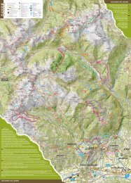
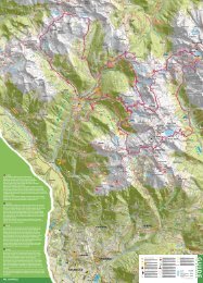
How to reacH GriGno<br />
and Marcesina plateau<br />
Grigno can be reached through the main road<br />
<strong>Valsugana</strong> SS. 47 or by train, with the Trento -<br />
Venezia railway line. The closet airports are “Catullo”<br />
in Verona and “Marco Polo” in Venice. It is located<br />
at about 50 km from Trento and 80 km from Padova.<br />
It is possible to get to Marcesina Plateau from Selva<br />
di Grigno (with a permit issued by the municipality)<br />
and from Enego, through Valmaron.<br />
&<br />
ALTOPIANO<br />
DELLA<br />
Marcesina Grigno<br />
Come raggiungere Grigno<br />
e l’altopiano della Marcesina<br />
Grigno è raggiungibile con la SS. 47 della <strong>Valsugana</strong> o con<br />
la Ferrovia Trento-Venezia. Dista circa 50 km da Trento e<br />
80 km da Padova. Gli aeroporti più vicini sono il “Catullo”<br />
di Verona e il “Marco Polo” di Venezia.<br />
L’altopiano della marcesina si raggiunge o dalla frazione<br />
di Selva di Grigno con permesso rilasciato dal comune<br />
oppure da Enego (VI) attraversando la Valmaron.<br />
wie erreicHt Man GriGno<br />
und die HocHeBene der Marcesina<br />
Grigno erreicht man über die Staatsstraße 47 des<br />
<strong>Valsugana</strong> und die Bahnlinie Trento-Venezia. Der Ort<br />
liegt 50km von Trento und 80km von Padua entfernt.<br />
Die nächst gelegenen Flughäfen sind der Flughafen<br />
“Catullo” in Verona und “Marco Polo” in Venedig.<br />
Die Hochebene der Marcesina erreicht man vom<br />
Ortsteil Selva di Grigno aus, dazu benötigt man eine<br />
Genehmigung, die man auf der Gemeinde erhalten<br />
kann oder von Enego aus durch das Tal Valmaron.<br />
info<br />
Copyright: Michele Dalla Palma - APT <strong>Valsugana</strong> - Luca Girotto - Ass. Sisampa<br />
Comune di Grigno - Museo Tridentino di Scienze Naturali - AdT Cristian Marchetto<br />
AZIENDA PER IL TURISMO VALSUGANA - LAGORAI - TERME - LAGHI<br />
Villa Sissi - Parco delle Terme, 3 • 38056 Levico Terme (Tn) - Italy Tel. +39 0461 727700 - Fax +39 0461 727799<br />
info@valsugana.info - www.valsugana.info<br />
Richiedi anche le altre cartine! / Ask for other maps! / Fragen Sie auch nach den anderen Karten! / Vraag ook de andere kaarten aan!<br />
PRICE<br />
2 Euro<br />
COMUNE DI<br />
GRIGNO<br />
&<br />
ALTOPIANO<br />
DELLA<br />
GUIDA AI SENTIERI<br />
Marcesina Grigno<br />
Altopiano<br />
della Marcesina<br />
La piana di Marcesina è una gran distesa di pascoli circondata<br />
da boschi di conifere e ricca di malghe per l’alpeggio estivo, a<br />
ridosso del confine tra la regione Veneto. Quest’area, denominata<br />
la Finlandia d’Italia, si estende su un deposito morenico originato dall’ultima glaciazione würmiana.<br />
L’altopiano è la meta ideale per chi ama il trekking, la mountain bike e le passeggiate a cavallo: dal<br />
rifugio Barricata partono diverse strade sterrate forestali interdette al traffico che portano a Gallio,<br />
Asiago, sull’Altopiano di Folgaria, sul Vezzena e sul Monte Ortigara, passando per scenari stupendi e<br />
incontaminati.<br />
Marcesina Plateau is a wide expanse of pastures surrounded by coniferous forests, with a lot of areas destined<br />
for alpine pastures in summer (“malghe”), on the border of Veneto region. This area, also known as “the Finland of<br />
Italy”, extends on a moraine originated after the last wurm glaciation.<br />
The Plateau is the perfect destination for those who love trekking, mountain bike and horse riding: from Barricata<br />
Alpine Hut start several paths closed to traffic that lead to Gallio, Asiago, Folgaria Plateau, Vezzena and Monte<br />
Ortigara through beautiful and unspoiled sceneries.<br />
Die Ebene der Marcesina ist eine weite Fläche mit Weiden, umgeben von Nadelbaumwäldern und reich an Almen<br />
für das Weiden der Tiere im Sommer. Sie liegt an der Grenze zur Region Venetien. Dieses Gebiet, auch Finnland Italiens<br />
genannt, erstreckt sich auf einer Moränenablagerung,<br />
die aus der letzten Würmeiszeit stammt.<br />
Die Hochebene ist das ideale Ziel für alle Trekking-<br />
Mountainbike-und Reitliebhaber: an der Berghütte Barricata<br />
beginnen zahlreiche Forststraßen, die man nur<br />
zu Fuß zurücklegen kann und die nach Gallio, Asiago,<br />
auf die Hochebene Folgaria, auf die Hochebene von<br />
Vezzena und auf den Berg Ortigara führen, vorbei an<br />
wunderschönen und naturbelassenen Landschaften.<br />
Bike<br />
ciclaBile della ValsuGana La ciclopista della <strong>Valsugana</strong>, che collega il Lago di Caldonazzo con<br />
Bassano del Grappa, è un vero e proprio paradiso per tutti gli appassionati delle due ruote a pedali: 80<br />
km lungo i quali si intrecciano cultura, storia e paesaggi naturali davvero unici a cavallo tra Trentino e<br />
Veneto.<br />
Il Bici Grill in località Tezze di Grigno rappresenta la tappa ideale per interrompere la pedalata e<br />
concedersi una pausa rilassante. All’altezza di Grigno dalla ciclabile partono due salite da mito, la Strada<br />
del Murello e la Strada Selva-Barricata.<br />
ValsuGana cYclinG patH <strong>Valsugana</strong> cycling path, that links Caldonazzo Lake with Bassano del Grappa,<br />
is a real paradise for bike lovers: over 80 km that straddle Trentino and Veneto regions, history and culture mingle<br />
with unique natural landscapes. The Bici Grill in Tezze di Grigno represents a perfect layover to stop cycling and<br />
have a relaxing break. From the cycling Path in Grigno start two legendary uphill roads, “Strada del Murello” and<br />
“Strada Selva-Barricata”<br />
der radweG des ValsuGana Der Radweg des <strong>Valsugana</strong>, der den Caldonazzosee mit Bassano del Grappa<br />
verbindet, ist ein wahres Paradies für alle Liebhaber des Sportes auf zwei Rädern: 80km Kultur, Geschichte und wunderschöne<br />
natürliche Landschaften zwischen den Regionen Trentino und Veneto. Der Bici Grill in der Lokalität Tezze di<br />
Grigno ist ein ideales Ziel, um die Radtour zu unterbrechen und sich eine erholsame Pause zu gönnen. Auf dem Radweg,<br />
Höhe Grigno, beginnen zwei bedeutende Anstiege- die Strada del Murello und die Strada Selva-Barricata.<br />
strada del Murello La salita del Murello è una classica da affrontare con bici da corsa,<br />
mountainbike o skiroll. Partendo dal comune di Grigno dopo circa 500 metri si incontra alla propria<br />
destra la chiesetta di Sant’Uldarico. Dopo poche centinaia di metri è possibile ammirare il paesaggio<br />
dal ponte del Diavolo e salendo ancora per alcuni tornanti si lascia sulla sinistra la strettissima valle del<br />
torrente Grigno dove scende il famosissimo percorso “Apocalypse now”. Il rettilineo finale porta fino<br />
all’abitato di Castello Tesino.<br />
Lunghezza: 10 Km, dislivello: circa 700 m.<br />
strada del Murello Murello uphill road is a must to ride with a racing bike, mountain bike or skiroll. Starting<br />
from Grigno with direction Tezze, go on the left and take the winding road. After a hundred meters it is possible<br />
to admire the scenery from Ponte del Diavolo; going on, on the left side there is the really narrow valley of Grigno<br />
stream, where the well-known “Apocalypse Now” track descends. The final straight leads to Castello Tesino.<br />
Length: 10 km. Vertical Height Difference: about 700.<br />
strasse Murello La Der Anstieg des Murello ist ein Klassiker, den man mit einem Rennrad, einem<br />
Mountainbike oder dem Skiroll zurücklegen kann. Von der Gemeinde Grigno fährt man in Richtung Tezze, es geht<br />
sofort bergauf auf der links liegenden Straße, die in Kehren ansteigend verläuft. Nach wenigen hundert Metern kann<br />
man die Landschaft der Ponte del Diavolo (Brücke des Teufels) bewundern und weiter bergauf lässt man dann das<br />
enge Tal des Baches Grigno hinter sich. Hier verläuft der berühmte Parcours „Apocalypse now“ bergab. Die Gerade<br />
führt dann bis zum Ort Castello Tesino. Länge: 10km. Höhenunterschied: ca. 700m.<br />
strada selVa-Barricata La salita all’altopiano dei Sette Comuni parte dalla frazione Selva di<br />
Grigno. Questa salita è abbastanza impegnativa. Il paesaggio si dimostra suggestivo perché la strada<br />
costeggia la montagna e si trova a picco sulla <strong>Valsugana</strong>. Passato il ponte di legno a circa metà<br />
percorso, la strada concede una piccola tregua diventando quasi pianeggiante per poi salire per il Col<br />
del Vento. Dopo un lungo rettilineo nel bosco si sale ancora per circa 3 km fino a raggiungere gli ampi<br />
prati dell’altopiano. Lunghezza: 13 Km, dislivello: circa 1.100 m.<br />
speleologia<br />
selVa-Barricata road The uphill to the “Sette Comuni” Plateau starts<br />
from the hamlet Selva di Grigno. This rise is quite demanding. The landscape is<br />
impressive, because the road is along the mountain and is sheer on <strong>Valsugana</strong>.<br />
After the wooden bridge halfway, the road becomes more plain to ascend again<br />
on Col del Vento. After a long straight in the forest, the road ascends for 3 km<br />
more until the wide fields in the Plateau.<br />
Length: 13 km. Vertical Height Difference: 1.100 m.<br />
strasse selVa-Barricata Der Anstieg zur Hochebene der 7 Kommunen<br />
beginnt im Ortsteil Selva di Grigno. Dieser Anstieg ist sehr anstrengend. Das<br />
Landschaftsbild ist suggestiv, denn die Straße verläuft direkt am Felsen und<br />
direkt am Abgrund zum <strong>Valsugana</strong>. Nach der Ponte del Legno (Holzbrücke),<br />
auf der Hälfte der Strecke, lässt die Straße eine kleine Verschnaufpause zu<br />
und wird fast eben, um dann zum Col del Vento ansteigend zu verlaufen. Nach<br />
einer langen Geraden im Wald geht es noch ca. 3km bergauf bis zu den weiten<br />
Almwiesen der Hochebene.<br />
Länge: 13km. Höhenunterschied: 1.100m.<br />
Il Biotopo Fontanazzo<br />
Situato presso la frazione Selva di Grigno, comprende prati,<br />
coltivi, diversi corsi d’acqua, lembi di foresta alluvionale e tratti<br />
di bosco ripariale. Nel fitto della vegetazione trovano possibilità<br />
di rifugio, alimentazione e riproduzione numerose specie di uccelli e mammiferi. Uno tra i maggiori<br />
motivi di interesse naturalistico del Biotopo Fontanazzo è costituito dal suo particolare sistema idrico: la<br />
zona comprende infatti alcune importanti sorgenti che sono in diretta comunicazione con le grotte della<br />
Bigonda e del Calgeron. All’interno del biotopo si può seguire un interessante percorso naturalistico.<br />
Located in Selva di Grigno, it comprises fields, cultivations, streams, corners of floodplain and riparial forests.<br />
In the thick vegetation numerous species of birds and mammalian have the opportunity of taking refuge, feeding<br />
and reproducing. The particular water system is one of the most important reasons that make Fontanazzo Biotope<br />
interesting from a naturalistic perspective: the area comprises relevant springs that flow directly to Bigonda and<br />
Calgeron Grottos. In the biotope it is possible to follow an interesting naturalistic path.<br />
Es befindet sich im Ortsteil Selva von Grigno. Es<br />
umfasst Wiesen, Feldern, Wasserläufen, Stücke von<br />
alluvialen Wäldern und Teile von Uferwäldern. In der<br />
dichten Vegetation finden verschiedene Arten von Vögeln<br />
und Säugetieren Zuflucht, Nahrung und Fortpflanzungsrau.<br />
Eines der Hauptmotive des Biotops Fontanazzo ist<br />
aus naturalistischen Gesichtspunkten sein besonderes<br />
Wassersystem: das Gebiet umfasst in der Tat einige<br />
wichtige Quellen, die direkt mit der Grotte der Bigonda und<br />
Calgeron verbunden sind. Im Inneren des Biotops kann man<br />
einen interessanten Naturparcours zurücklegen.<br />
Riparo Dalmeri<br />
Il Riparo Dalmeri sull’altopiano della Marcesina ha rappresentato<br />
negli ultimi vent’anni di ricerca preistorica un sito archeologico di<br />
riferimento per capire il modo in cui l’uomo preistorico sfruttava<br />
il territorio montano alla fine del paleolitico, circa 13.000 anni fa.<br />
La scoperta di numerose pietre dipinte in ocra rossa ha permesso nuove interpretazioni sull’arte e sulla<br />
spiritualità degli antichi cacciatori-raccoglitori dell’Altopiano.<br />
In the last twenty years of prehistoric research, Riparo Dalmeri on the Marcesina Plateau has represented an<br />
archaeological landmark to understand in which way the prehistoric men used to operate on the mountain terrain at<br />
the end of the Palaeolithic Age, about 13.000 years ago. The discovery of several stones painted in red ochre has<br />
allowed new interpretations about art and about the spirituality of the ancient hunters and pickers of the Plateau.<br />
Das Riparo Dalmeri auf der Hochebene der Marcesina wurde in den letzten 20 Jahren prähistorischer Suche<br />
nach einem wichtigen archäologischen Bezugspunkt, um herauszufinden, wie der prähistorische Mensch am Ende des<br />
Paläolithikum, vor ca. 13.000 Jahren, die Bergregion nutzte. Die Entdeckung zahlreicher ocker-rosa angemalter Steine<br />
ermöglichte eine neue Interpretation der Kunst und der Spiritualität der antiken Sammler und Jäger der Hochebene.<br />
Grande Guerra<br />
Durante la Prima Guerra Mondiale, tra il 10 e il 29 giugno 1917,<br />
il Monte Ortigara fu teatro di una terribile e sanguinosa battaglia<br />
costata la vita a 28.000 soldati italiani.<br />
In quel periodo, nella zona dell’attuale Rifugio Barricata, stazionavano circa 5.000 muli utilizzati dai 300.000<br />
alpini per il trasporto di munizioni e viveri. Merita una visita il Trincerone di Grigno costruito dagli italiani<br />
nel 1916 lungo la sinistra orografica del torrente Grigno come sbarramento della <strong>Valsugana</strong> rivolto verso il<br />
confine. Non servì a nulla perché gli austriaci, dopo lo sfondamento di Caporetto, arrivarono da Feltre e gli<br />
italiani furono costretti a fuggire. Info: www.mostradiborgo.it<br />
During the First World War, between 10 and 29 June 2017, Monte Ortigara has been the scenery of a terrible and<br />
bloody battle that 28.000 Italian soldiers paid with their lives. In that period, about 5.000 donkeys used by the 300.000<br />
members of the alpine troops to transport munitions and food supplies, were staying in the area where nowadays<br />
stands Barricata Alpine Hut. The Trincerone di Grigno (“Big Trench”), built by the Italians in 1916 on the left side of<br />
Grigno torrent as barrier on the border, is worth a visit. It has been useless because after the Battle of Caporetto,<br />
the Austrians came from Feltre and the Italians were forced to flee. Info: www.mostradiborgo.it<br />
Während des Ersten Weltkrieges, zwischen dem 10. und dem 29. Juni 1917 wurde der Berg Ortigara Schauplatz<br />
einer schrecklichen und blutigen Schlacht, die 28000 italienischen Soldaten das Leben kostete. Zu dieser Zeit, in der<br />
Gegend der heutigen Berghütte Barricata waren ca. 5000 Maulesel stationiert die widerum von 300000 Gebirgsjägern<br />
für den Transport von Verpflegung und Munition genutzt worden.<br />
Der große Schützengraben von Grigno, der 1916 von den Italienern an der<br />
orografisch linken Seite des Baches Grigno gebaut wurde, lohnt eine Besichtigung.<br />
Er diente als Absperrung des <strong>Valsugana</strong> hin zur Grenze.<br />
Es nutzte nichts, denn die Österreicher kamen, nach dem Durchbruch<br />
von Caporetto, von Feltre und die Italiener mussten flüchten. Info:www.<br />
mostradiborgo.it<br />
sport/hobbies<br />
Monte Ortigara 2106 m<br />
e Cima Caldiera 2124 m<br />
Questo percorso costituisce indubbiamente l’itinerario<br />
più completo e significativo per visitare il campo di battaglia<br />
dell’Ortigara, teatro di alcune tra le più cruente battaglie<br />
combattute durante il primo conflitto mondiale sull’intero fronte italiano. Partenza: Piazzale lozze 1771 m.<br />
Without any doubt, this path is the most complete and meaningful itinerary to visit the battlefield of Ortigara,<br />
stage of some of the bloodiest battles fight during the First World War on the Italian front line.<br />
Starting point: Piazzale Lozze 1771 m.<br />
Diese Strecke umfasst ohne Zweifel den komplettesten und signifikantesten Wanderweg, um das Schlachtfeld<br />
des Berges Ortigara zu besichtigen. Hier fanden während des Ersten Weltkrieges einige der blutigsten Kämpfe der<br />
italienischen Front statt. Anfangspunkt: Platz Piazzale Lozze 1771m.<br />
Castelloni di San Marco<br />
1830 m<br />
Questo sentiero attraversa nella parte sommitale un vero e<br />
proprio labirinto di pietra, finemente modellato dai ghiacciai e<br />
dagli agenti atmosferici. Il sentiero dei Castelloni di San Marco<br />
offre panorami impareggiabili e rappresenta sicuramente uno dei luoghi più singolari e suggestivi dell’intero<br />
altopiano. Partenza: Malga Fossetta 1666 m.<br />
In its upper part this path crosses a real stone labyrinth, finely shaped by glaciers and by the weather. Castelloni<br />
di San Marco way offers incomparable views and represents one of the most unique and evocative places of the<br />
whole Plateau. Starting point: Malga Fossetta 1666 m.<br />
Dieser Wanderweg überquert im höchsten Teil ein wahres Labyrinth an Steinen, von der Eiszeit und den Umwelteinflüssen<br />
fein modelliert. Der Weg der Castelloni di San Marco bietet unvergleichliche Panoramen und stellt einen der einzigartigsten<br />
und suggestivsten Orte der gesamten Hochebene dar. Ausgangspunkt: Almhütte Malga Fossetta 1666m.<br />
Sentiero dei Cippi<br />
Questo sentiero segue per buona parte il confine tra Veneto<br />
e Trentino dove sono ancora presenti le pietre confinarie datate<br />
1752 che delimitavano il territorio tra l’Impero Asburgico e la<br />
Repubblica di Venezia. Sul cippo n. 1, chiamato Anepoz per la sua forma ad incudine, a picco sulla<br />
<strong>Valsugana</strong> erano fissate le formelle con le effigi dello Scudo di Maria Teresa d’Austria ed il Leone di S.<br />
Marco. Il percorso si distingue in 869 per l’andata e 869B per il ritorno.<br />
This path mostly follow the boundary between Veneto and Trentino Regions where the border stones dated 1752 that<br />
were dividing the territories between the Austrian Hungarian Empire and the Serenissima Venetian Republic are still present. On<br />
the first milestone, called Anepoz because it seems anvil shaped, sheer on <strong>Valsugana</strong> there were the panels with the effigies<br />
of the Shield of Maria Theresa of Austria and St. Mark’ s Winged Lion. The path is known as 869 to go and as 869B to return.<br />
Dieser Wanderweg folgt ein ganzes Wegstück<br />
dem Grenzverlauf zwischen den Regionen Veneto und<br />
Trentino, wo es immer noch die Grenzsteine aus dem<br />
Jahr 1752 gibt, die das Territorium des Österreichischen<br />
Kaiserreichs und der Republik Venedig kennzeichneten.<br />
Auf dem Grenzstein Nr. 1, aufgrund seiner Amboß-Form<br />
Anepoz genannt, steil über dem <strong>Valsugana</strong>, hat man<br />
Tafeln mit dem Wappen Maria Theresas von Österreich<br />
und dem Löwen von San Marco angebracht. Die Strecke<br />
teilt sich in Weg Nr. 869 hin und in Weg Nr. 869B zurück.<br />
Sentiero della Pertega<br />
Tempi medi di percorrenza /Time / Durchschnittliche<br />
Wanderzeit / Duur van de route: 5-6 h<br />
Dalla località Selva, nei pressi dell’area sosta, inizia il sentiero<br />
che seguendo mulattiere e antichi sentieri usati dai soldati si<br />
inerpica verso l’altopiano della Marcesina. L’ultimo tratto del<br />
sentiero diventa via via più pianeggiante e attraversa uno splendido bosco di abeti. Usciti dal bosco si<br />
trova la Pria della Messa e dopo 10 minuti di cammino si arriva al Rifugio Barricata.<br />
From the hamlet of Selva, close to the rest area, starts the path that slopes up the Marcesina Plateau following<br />
mule tracks and ancient paths used by soldiers. The last part of the route becomes more and more plain and crosses<br />
a beautiful pine forest. Out of the forest there is “Pria della Messa” and after a 10 minute walk it is possible to get<br />
to Barricata Alpine Hut.<br />
Vom Ortsteil Selva aus, in der Nähe der Raststätte, beginnt der<br />
Wanderweg, der ehemaligen Pfaden und antiken Wegen folgt, die<br />
einst von den Soldaten benutzt worden, die zur Hochebene Marcesina<br />
hinaufstiegen. Das letzte Wegstück wird nach und nach immer<br />
ebener und führt durch einen wunderschönen Tannenwald. Sobald<br />
man aus dem Wald hinaus kommt findet man Pria della Messa und<br />
nach 10min Wanderung erreicht man die Berghütte Rifugio Barricata.<br />
speleoloGY Dal punto di vista speleologico il territorio di Grigno è unico: numerose sono infatti<br />
le cavità carsiche che testimoniano la forza erosiva del lento scorrere delle acque sotterranee. Le due<br />
grotte più conosciute sono la Grotta della Bigonda e quella del Calgeron.<br />
Per informazioni: Gruppo Grotte Selva: 347.7879221.<br />
speleoloGY The territory of Grigno is unique from a speleological perspective: several karsts caves testify<br />
the erosive forces of the slow groundwater’s flow over the millennia. The most known caves are Bigonda and<br />
Calgeron ones. Grotte Selva Group: 347.7879221.<br />
speläoloGie Aus speläologischen Gesichtspunkten ist das Territorium Girgnos einzigartig: es gibt zahlreiche<br />
karstige Höhlen, die Ausdruck einer tausendjährigen Erosionskraft der langsam unterirdisch fließenden Wasser sind.<br />
Die zwei bekanntesten Grotten sind die Grotta della Bigonda und die des Calgeron.<br />
Gruppe Grotte Selva: Mobil 347 7879221.<br />
canYoninG nella forra del GriGno Lungo il torrente Grigno è<br />
possibile fare canyoning: vi è una profondissima forra calcarea che per<br />
due terzi del percorso non coglie un solo raggio di sole. Questa gola è<br />
nota con il nome di Apocalypse Now o come “Bus (buco) del Diaolo”.<br />
canYoninG in GriGno GorGe Along Grigno stream, in the turbulent<br />
waters, it is possible to practice canyoning in the deep limestone gorge that<br />
does not see the sun for two-thirds of the track. This canyon is known as “Apocalypse<br />
Now” or “Bus del Diaolo” (Devil’s Hole).<br />
canYoninG in der scHlucHt Von GriGno Entlang des Baches Grigno<br />
kann man in rauschenden Wassern, in einer tiefen Kalkschlucht canyoning<br />
praktizieren. Auf zwei Dritteln der Fahrt bekommt man keinen Sonnenstrahl zu<br />
Gesicht. Diese Schlucht ist bekannt als „Apocalypse now“ oder als „Bus del<br />
Diavolo“ (Loch des Teufels).<br />
A PESCA I permessi di pesca vengono rilasciati solo all’esibizione della licenza di pesca in corso di<br />
validità. è possibile pescare dalla prima domenica di marzo fino all’ultimo giorno di settembre. Il giovedì<br />
non può pescare nessuno. I permessi ospiti costano 12,00 euro, sono previsti dei permessi giornalieri che<br />
vengono emessi dall’unico punto vendita, Osteria ai Serafini. Le specie ittiche presenti sono: trote fario,<br />
marmorata, iridea, temolo e altri tipi.<br />
A FUNGHI L’altopiano della Marcesina è una vera riserva di funghi: la raccolta dei funghi per i cittadini<br />
non residenti in provincia di Trento sul territorio del comune di Grigno è subordinata al pagamento di una<br />
tariffa da versare tramite conto corrente postale (n. 12748380 intestato al comune di Grigno). Nel comune<br />
di Grigno l’unica struttura che rilascia i permessi è il Rifugio Barricata che si trova sull’altopiano della<br />
Marcesina.<br />
1 giorno - 10,00 euro, 3 giorni - 20,00 euro, 1 settimana - 25,00 euro, 2 settimana - 40,00 euro, 1 mese - 60,00 euro.<br />
FISHING Fishing permits can be released only if a valid fishing licence is shown. It is possible to fish from the<br />
first Sunday of March until the last day of September. Guest’s permits cost € 12,00; daily permits are available only at<br />
Osteria ai Serafini. The fish species are brown trout, marble trout, rainbow trout, grayling and others.<br />
MUSHROOMS Marcesina Plateau is a real mushroom reserve: those who are not resident in Trento Municipality and<br />
want to pick mushrooms in the area of Grigno must pay a fee through postal account (no. 12748380, Comune di Grigno).<br />
In the area of Grigno permits are released only at Barricata Alpine Hut on Marcesina Plateau.<br />
1 day - 10,00 euro - 3 days - 20,00 euro, 1 week - 25,00 euro - 2 weeks - 40,00 euro, 1 month - 60,00 euro.<br />
ANGELN Die Angelerlaubnisse werden nur bei Vorlage eines gültigen Angelscheins verkauft. Man kann vom ersten<br />
Sonntag im März bis zum letzten Tag im September angeln. Die Gästeerlaubnis kostet 12,00 €. Es gibt auch Tageskarten,<br />
die man ausschließlich in der Osteria ai Stefani erwerben kann.<br />
Die vorkommenden Fischarten sind: Forellen, Marmorataforelle, Regenbogenforelle, Äsche und andere Typen<br />
PILZE SAMMELN Die Hochebene der Marcesina<br />
ist ein wirkliches Pilzgebiet: die nicht in<br />
der Provinz von Trient Ansässigen müssen zum<br />
Pilze sammeln auf dem Gebiet der Gemeinde<br />
Grigno eine Quote überweisen, auf das Konto<br />
(Kontonummer 12748380, Kontoinhaber Gemeinde<br />
Grigno). In der Gemeinde Grigno vergibt<br />
ausschließlich die Berghütte Rifugio Barricata<br />
die Sammelerlaubnis, sie befindet sich auf der<br />
Hochebene der Marcesina.<br />
1 Tag – 10,00 € - 3 Tage 20,00 €, 1 Woche- 25,00<br />
€- 2 Wochen 40,00 €, 1 Monat 60,00 €.<br />
Eventi<br />
Brusa la vecia, Festa della befana<br />
‘Ncontramarzo, Bigolada<br />
Festa del sole<br />
Festa del pesce, Festa padronale madonna ausiliatrice<br />
Su e do per el Masaron, Festa padronale S. Antonio<br />
Brenta Summer Trophy, festa padronale S. Giacomo<br />
Festa della montagna, Festa sull’altopiano, Festa alpina<br />
Raduno ciclistico<br />
Festa del Seleno, Castagnata<br />
Nadale soto i porteghi, Drioghe la Stela<br />
Gennaio - January - Januar<br />
Febbraio - February - Februar<br />
Marzo - March - März<br />
Maggio - May - Mai<br />
Giugno - June - Juni<br />
Luglio - July - Juli<br />
Agosto - August - August<br />
Settembre - September - September<br />
Ottobre - October - Oktober<br />
Dicembre - December - Dezember<br />
inverno/winter<br />
Info<br />
www.valsugana.info<br />
Durante l’inverno i sentieri dell’altopiano si trasformano in un sistema di ben 200 km di piste per lo<br />
sci nordico e le racchette da neve; in questa stagione il Rifugio Barricata diventa raggiungibile solo a<br />
piedi. Le piste più facili nella piana di Marcesina soddisfano le esigenze dei fondisti principianti, mentre<br />
i percorsi che raggiungono i 2000 metri di malga Fossetta, Moline e Ortigara sono adatti ai sciatori più<br />
esperti o in motoslitta.<br />
In winter the tracks on the Plateau become a system of 200 km for Nordic skiing and snowshoes; in this season<br />
it is possible to get to Barricata Alpine Hut only on foot. The easiest tracks on Marcesina Plateau are perfect for<br />
cross-country skiing beginners, while the routes that reach 2000 m of Malga Fossetta, Moline and Ortigara are more<br />
suitable for experienced skiers.<br />
Den Winter über verwandelt sich die Hochebene in ein System mit 200 Pistenkilometern für den Langlauf und<br />
die Schneeschuhe. In diesem Zeitraum erreicht man die Berghütte Barricata nur zu Fuß. Die einfachen Pisten in der<br />
Ebene der Marcesina werden die Anfänger zufrieden stellen, während die Strecken, die 2000m und die Almhütte<br />
Malga Fossetta, Moline und Ortigara erreichen etwas für erfahrene Skifahrer sind.<br />
Casearia Monti Trentini<br />
• Apertura Annuale: 8.00 / 12.30 - 15.30 / 19.00<br />
chiuso domenica tutto il giorno e lunedì pomeriggio.<br />
Dal produttore al consumatore...<br />
Produzione formaggi trentini.<br />
• Annual opening: 8.00 / 12.30 - 15.30 / 19.00<br />
Closed all day on Sunday and on Monday afternoon.<br />
From producer to consumer...<br />
Production of traditional cheese made in Trentino region.<br />
Indirizzo • Address:<br />
38055 Grigno (TN)<br />
Tel. +39 0461 775800<br />
Fax +39 0461 775899<br />
www.montitrentini.it<br />
Rifugio Barricata<br />
• Apertura da giugno ad ottobre<br />
e da dicembre ad aprile.<br />
Pernottamento in 29 stanze dotate di ogni comfort:<br />
bagno completo, asciugacapelli, televisore, corredo<br />
di biancheria da letto ed asciugamani personali<br />
Menu a base di ricette tipiche, elaborate<br />
con prodotti locali.<br />
Cucina aperta tutto il giorno. Bar. Servizi<br />
• Open Opened from June to October<br />
and from December to April.<br />
29 bedrooms equipped with: bathroom, hairdryer,<br />
television, bed linen and towels. Menu with<br />
traditional dishes, cooked with local products.<br />
Restaurant open all day long.<br />
Indirizzo • Address:<br />
Alt. 1351 metri s.l.m.<br />
Località Barricata 38055 Grigno (TN)<br />
Tel. +39 0461 765139<br />
Cell. gestore +39 334 6729380<br />
www.rifugiobarricata.it<br />
info@rifugiobarricata.it<br />
Azienda per il turismo <strong>Valsugana</strong> – Lagorai, Laghi e Terme<br />
Piazza Degasperi – Borgo <strong>Valsugana</strong> (tn) – Italy Tel. 0461 727740 – fax 0461 752393<br />
borgovalsugana@valsugana.info - www.valsugana.info<br />
NUMERI UTILI / Im Notkall / Nützliche Telefonnummern / Eerste Hulp<br />
Emergenza sanitaria – Medical Emergency – Notarzt 118<br />
Vigili del fuoco – Fireman – Feuerwehr – brandweer 115<br />
Carabinieri – Police – Polizei – Politie 112<br />
Comune di Grigno<br />
0461/ 775111 – Fax 0461 775130 - comune@comunegrigno.it<br />
Pro Loco Grigno<br />
www.prolocogrigno.it<br />
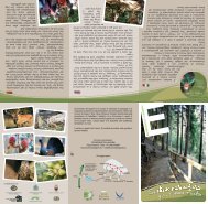
ASSOCIAZIONE SISAMPA<br />
Questa associazione nasce per trasmettere a tutti - soprattutto ai giovani - la CULTURA e la<br />
PASSIONE per lo SPORT in MONTAGNA, organizzando nell’arco di tutto l’anno escursioni, corsi,<br />
meeting e lavori manuali per conoscere e preservare la montagna.<br />
Cell. 331-5696380 associazionesisampa@libero.it - www.sisampa.org<br />
This Association is born to communicate –most of all to young people- the culture and love for mountain sports; it organizes<br />
excursions, courses, meeting and workshops all year long, to know and preserve the nature.<br />
associazionesisampa@libero.it - www.sisampa.org - Cell. 331-5696380.<br />
Dieser Verein wurde ins Leben gerufen, um allen, v.a. den Jungen – die KULTUR und die LEIDENSCHAFT für den SPORT in den BERGEN<br />
nahe zu bringen. Das ganze Jahr über organisiert er Exkursionen, Kurse, meetings und Arbeitseinsätze, um die Berge vorzustellen und zu<br />
bewahren. Mobil +39 331 5696380 - associazionesisampa@libero.it - www.sisampa.org<br />
NORME COMPORTAMENTALI. Vi preghiamo di seguire alcune norme di comportamento, per il rispetto del luogo. Evitate di gettare carte,<br />
mozziconi, sporcare e di allontanarsi dal tracciato del sentiero.<br />
BEHAVIOUR RULES. We ask you kindly to obey some behaviour rules and to respect this place. Don’t throw away paper, stubs, don’t dirty<br />
and don’t leave the signed paths.<br />
VERHALTENSREGELN. Sie werden gebeten einige Verhaltensregeln, zum Schutz dieses Gebietes zu beachten. Vermeiden Sie es Papier und<br />
Zigarettenstummel fallen zu lassen, Müll zu hinterlassen und von den bestehenden Wegen abzuweichen.