Geocentro Magazine - Fondazione Geometri
Geocentro Magazine - Fondazione Geometri
Geocentro Magazine - Fondazione Geometri

You also want an ePaper? Increase the reach of your titles
YUMPU automatically turns print PDFs into web optimized ePapers that Google loves.
alla necessità non più procrastinabile di attuazione di una<br />
perequazione fiscale, basata sul possesso di beni immobili,<br />
così come suggerito dalle teorie fisiocratiche illuministiche.<br />
Il primo, grande laboratorio sperimentale e didattico nel<br />
campo del rilevamento sistematico del territorio a grande<br />
scala si ha proprio con la formazione del catasto geometricoparticellare<br />
milanese o Teresiano, che pur se mostra i suoi<br />
forti limiti scientifici nella mancanza di una specifica rete<br />
geodetica di appoggio, attua una delle più ampie opere di<br />
conoscenza del territorio e, sotto la guida del matematico<br />
Giovanni Giacomo Marinoni (1676 - 1755), realizza una<br />
vasta opera di formazione professionale, creando una nuova<br />
classe di topografi e cartografi, che vengono educati all’uso<br />
della tavoletta pretoriana (vedi pagina 53) e alle rigide regole<br />
del disegno topografico.<br />
A questa vasta schiera di nuovi tecnici appartiene in<br />
particolare l’eccellente geometra comasco Giambattista Nolli<br />
(1701 - 1756), che si definisce “geometra e architetto”,<br />
formatosi proprio in quel laboratorio di scienza e di tecnica<br />
che fu il Catasto Teresiano.<br />
Como, Giambattista Nolli (1701-1756). He called himself<br />
“surveyor and architect” and received his education in that<br />
scientific and technical laboratory represented by the Cadastre<br />
of Maria Theresa.<br />
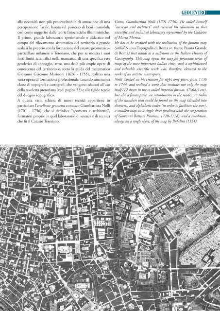
He has to be credited with the realisation of the famous map<br />
(called Nuova Topografia di Roma or, better, Pianta Grande<br />
di Roma) that stands as a milestone in the Italian History of<br />
Cartography. This map opens the way for fortunate series of<br />
maps of the most important Italian cities, such a sophisticated<br />
and valuable scientific work was, therefore, elevated to the<br />
ranks of an artistic masterpiece.<br />
Nolli worked on his creation for eight long years, from 1736<br />
to 1744, and realised a work that includes not only the map<br />
itself (12 sheets in the so called imperial format, 47x68,9 cm),<br />
but also a frontispiece, an introduction to the reader, an index<br />
of the numbers that could be found on the map (divided into<br />
districts), and alphabetic index (in order to facilitate the user),<br />
a smallest map on a single sheet (realised with the cooperation<br />
of Giovanni Battista Piranesi, 1720-1778), and a re-edition,<br />
always on a single sheet, of the map by Bufalini (1551).