a cura di A.Bucci,G .Cafiero,M.Principi - Giovanna Mathis
a cura di A.Bucci,G .Cafiero,M.Principi - Giovanna Mathis a cura di A.Bucci,G .Cafiero,M.Principi - Giovanna Mathis
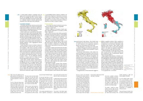
56 Anconapaco > 2. Le linee di ricerca del progetto > 2. Linjat e kerkimit te projektit > 2.Project research guidelines > 3. Presidio agricolo: criteri di aggregazione e classificazione territoriale > 3. Mbrojtja bujqesore: kriteret e bashkimit dhe tipologjite territoriale > 3. Agricultural occupation: aggregation criteria and territorial typologies >> 4. > 4. Presidio agricolo: rappresentazione finale > 4. Mbrojtja bujqesore: paraqitja perfundimtare > 4. Agricultural occupation: final representation preliminary classification of 9 different classes of agricultural presence was constructed, as before.These 9 classes were then subject to further aggregation and went from 9 to 5 sets, a final concise representation of 5 typologies of anthropic pressure. This basic crosscheck between population density and dynamics was weighted in order to cover urban processes not strictly related to resident population. In each comune the number of incoming commuters, people working or studying in the area but >> presenza agricola è rappresentato dai processi di urba- >> nizzazione4 , qui particolarmente intensi ed invasivi, anche per la specifica morfologia dell’insediamento industriale del distretto mobiliero. L’incidenza complessiva di questa tipologia nel territorio regionale (il 13% dei comuni, con il 12,7% della popolazione ed il 13,6% del territorio) è comunque assai più contenuta di quanto non si mostri nello scenario nazionale dove processi di abbandono del governo agricolo del territorio investono con forte intensità il 30% e più dei comuni italiani (con analoghe quote di popolazione e superficie). Ancora più modesto - e sostanzialmente complementare al precedente, a disegnare (assieme alle aree intermedie di cui si dirà oltre) una quasi ininterrotta continuità della dorsale appenninica - è il campo dei comuni ove analoghi fenomeni di riduzione del governo agricolo del territorio si presentano però con intensità minore: appena 8 comuni compongono la classe delle aree con problemi di abbandono che rappresentano quindi una frazione trascurabile della popolazione regionale (0,4%) ed occupano una porzione comunque esigua (5%) del suo territorio, anche in questo caso con una not permanently resident there, were estimated and numbers of tourists present were also estimated. These additional factors cause a comune to move into a higher class only where the nationally defined threshold is exceeded, that is, where the daily peak of population is over 20% higher, and where the yearly peak of population is over 50% higher, than resident population. Moreover, commuter flow is used only for the definition of intermediate classes and tourist flow is 3. nes Foglia, ku faktori i largimit te pranise bujqesore eshte i perfaqesuar nga procesi i urbanizimit. Ky proçes eshte veçanerisht intensiv dhe invaziv duke pasur parasysh dhe specifiken morfologjike te vendosjes ne kete territor te qarkut industrial te mobilerise. Ndikimi ne teresi i kesaj tipologjie mbi territorin krahinor (13% e bashkive, me 12,7% te popullsise dhe 13,6% te teritorit) eshte ne pergjithesi me i kufizuar sesa ai i skenarit kombetar ne te cilin proçesi i braktisjes se qeverisjes bujqesore te territorit perfshin 30% e me teper te bashkive italiane (me te dhena te njejta popullsie dhe siperfaqe). Akoma me modest – dhe kryesisht plotesues i asaj te meparshme per te vizatuar (bashke me zonat e ndermjetme per te cilat do te flitet me pas) nje vazhdimesi te panderprere te vargut te apenineve - eshte zona e bashkive ne te cilat fenomenet e pakesimit te qeverisjes bujqesore te territorit prezantohen me nje intensitet me te vogel: gati 8 bashki perbejne klasen e zonave me probleme braktisjeje duke krijuar nje fraksion te parendesishem te popullsise krahinore (0,4%) dhe duke zaptuar nje pjese shume te vogel (5%) te teritorit te saj, edhe ne kete rast me nje perqendrim shume me te used for urban and semi-urban areas where it constitutes a heavy pressure on local resources.Table 2 shows that the population is mainly stable and balanced. The Marche Region is characterized by marked differences between coast and inland areas, but population decline is affecting only a very few areas subject to depopulation. The phenomenon affects 27 comuni (11% of total, about 2% of population and 10% of territory), mainly located on the southern Apennine Aree con forti problemi di abbandono Zona me probleme te renda braktisje Areas with strong defection problems Aree con problemi di abbandono Zona me probleme braktisje Areas with defection problems Aree intermedie Zona te ndermjetme Intermediate areas Aree agricole in regresso Zona bujqesore te dobeta Declining agricultural areas Aree agricole forti Zona bujqesore te forta Strongly productive agricultural areas ridge. Note that, at national level, serious depopulation affects more than 25% of comuni, 10% of population and more than 30% of surface area. As a consequence, low density rural areas are more numerous compared to national data. These are areas affected by a positive demographic flow in the last ten-year period. 57 comuni or 23.2%, belong to this class, accounting for 7.4% of population and 30% of surface area. The comparable national percent- >> >> >> concentrazione nettamente inferiore a quella media nazionale. Un poco più esteso il campo dei comuni che si collocano in una posizione intermedia nella scala dei processi considerati (aree intermedie costituite da 27 comuni che ospitano un decimo circa della popolazione regionale pur governando un sesto del territorio). Anche questa componente è sottorappresentata nelle Marche rispetto al dato nazionale, ma gli scarti sono in questo caso ridotti a pochi punti percentuali. Emerge quindi con tutta evidenza l’eccezionale diffusione della caratterizzazione agricola dei comuni marchigiani che, nelle due ultime classi dove si concentrano i comuni nei quali l’incidenza della SAU sulla superficie territoriale complessiva supera la soglia critica individuata5 , si raggruppano per oltre i 2/3 del totale (a livello nazionale l’analoga incidenza è di poco superiore al 40%). Meno positivo è però il fatto che la più estesa delle classi sia quella costituita dalle aree agricole in regresso, aree nelle quali pur in presenza di una estesa e diffusa presenza del governo agricolo ha registrato una sostanziale riduzione della utilizzazione agricola del suolo, presumibilmente dovuta in questo caso tanto ai processi di urbanizzazione che all’abbandono dei coltivi marginali. Si tratta di ben 112 comuni, prevalentemente nel sistema costiero e collinare che ospitano la metà della popolazione della Regione pur occupando poco più di un terzo del suo territorio. Il confronto con il dato nazionale è eclatante giacché questa tipologia rappresenta in media un quinto dei comuni nazionali con analoga incidenza di popolazione e territorio. Significativa è appunto la presenza in questa classe di molti dei maggiori comuni urbani della regione che ne fa registrare una certa sproporzione tra peso demografico e peso territoriale. Per poco meno del 30% dei comuni marchigiani le aree agricole consolidate, (che rappresentano percentuali analoghe di territorio e popolazione), il presidio agricolo non è stato messo in discussione dalle dinamiche più recenti: qui lo scarto con il dato nazionale, pur positivo e significativo, è minore se è vero che questo nocciolo duro del presidio agricolo nazionale assorbe poco più del 20% dei comuni e quote analoghe di popolazione e territorio. ages are 15% of comuni or 5.3% population and 18.8% surface area. Similar considerations apply to intermediate areas, which have a lower incidence and are mainly situated in inland hill areas. Most comuni (more than 45% of total, which is similar to the national percentage) belong to prevailingly urban areas. There are two classes, with a clear predominance of highest pressure areas of recent urbanisation and economic development. Here the comuni number 93, or nearly 38% of total, corresponding to more than 53% of population. At national level these percentages are about 33% of comuni and 50% of population. Only 21 comuni belong to low growth urban and semi-urban areas that have suffered demographic decrease or stagnation in the last ten years. They represent 8.5% of total, but they are home to more than 25% of population. Comparative percentages for the whole of Italy are 14.2% of total comuni and 30% population. In this respect, the presence of towns along the coast (the regional capital, Pesaro, vogel ne krahasim me mesataren kombetare. Ndersa eshte pak me e madhe hapesira e bashkive qe ndodhen ne nje pozicion te ndermjetem ne shkallen e proceseve te konsideruara ( zonat e ndermjetme perbehen nga 27 bashki, kane rreth 1/10 e popullsise krahinore edhe pse qeverisin 1/6 e territorit). Edhe ne kete rast ky komponent eshte i nen prezantuar ne Marche ne krahasim me te dhenen kombetare, por megjithate mbetjetet jane te reduktuara ne pak pike perqindjeje. Del keshtu ne dukje shperndarja e jashtezakonshme e karakterizimit bujqesor te bashkive markixhane keshtu qe, dy klasat e fundit ku perqendrohen bashkite ne te cilat ndikimi i SAU-t mbi siperfaqen teritoriale te plote e kalon limitin kritik te percaktuar5 , zene me teper se 2/3 e totalit ( ne nivel kombetar i njejti ndikim eshte pak me teper se 40%). Me pak pozitiv eshte fakti qe klasa me e perhapur, ajo e perbere nga zonat bujqesore ne regres, zona ne te cilat edhe pse ekziston prezenca e shtrire e qeverisjes bujqesore ka regjistruar nje ulje thelbesore te perdorimit bujqesor te tokes. Shkak i ketij fakti mund te jete me shume procesi i urbanizimit sesa ai i braktisjes se kulturave me pak te rendesishme. Flitet per 112 bashki, qe gjenden ne sistemin bregdetar dhe kodrinor, dhe kane gati rreth gjysmen e popullsise se Krahines edhe pse zene pak me teper se 1/3 e territorit te saj. Krahasimi me te dhenen kombetare eshte i jashtezakonshem meqenese kjo tipologji perben mesatarisht 1/5 e bashkive kombetare me te njejtin ndikim te popullsise dhe territorit. E rendesishme eshte pikerisht prania ne kete klase e pjeses me te madhe te bashkive urbane te krahines qe ben te mundur verifikimin e nje sproporcioni midis peshes demografike dhe peshes territoriale. Ne rreth 30% te bashkive markixhane per zonat bujqesore te konsoliduara (qe prezantojne perqindje te njejte territori dhe popullsie) zaptimi bujqesor nuk eshte vene ne diskutim nga dinamikat me te fundit: ketu mbetja ne krahasim me te dhenen kombetare, edhe pse positive, eshte e vogel duke pasur parasysh qe berthama e forte e zaptimit bujqesor kombetar thith pak me teper se 20% te bashkive dhe kuota te njejta popullsie dhe territori. or San Benedetto del Tronto) or inland (Urbino or Fabriano) is important; in the last ten-years they have recorded a demographic decrease, which is only partially made up by various aspects of a pole of attraction constituted by a city. The Marche region is thus home to a rich variety of urban settlements which interacts intensively with the rural system. This situation generates a very complex mosaic of land use and urban morphologies. Territorial presence Comparison of typologies of anthropic pressure and agricultural presence provides an overview of territorial presence. To gain this picture, the two complex indicators are grouped into 3 classes and using the same aggregation techniques as described above, typologies are defined, 9 at first stage then 5 at the second stage. The territorial presence thus described shows a context characterized by well-defined elements, see 57 > Presidio umano e pressione antropica > Zaptimi i territorit nga njeriu dhe presioni antropik > Human presence and anthropic pressure
58 Anconapaco > 2. Le linee di ricerca del progetto > 2. Linjat e kerkimit te projektit > 2.Project research guidelines >> Table 3. The most significant are the great extension and compactness of maximum presence/pressure areas and the great importance of critical rural areas. The first of these two classes (maximum presence/pressure areas) covers almost the whole extent of the coastal hills, includes 135 comuni (55% of total, against 30% at national level), is home to more than 70% of population (twice the national rate) and occupies nearly half of the surface area (twice the national rate). >> In sintesi quindi le Marche si presentano come una regione ancora marcatamente agricola nella sua fisiono- >> Ne permbledhje krahina e Marche-s paraqitet si nje krahine akoma bujqesore ne fizionomine e saj (ne pejmia (nei suoi paesaggi) dove però i processi evolutivi sazhet e saj) ku proçeset evolutive te koheve te fundit recenti hanno rappresentato una forma di erosione diffu- kane paraqitur nje forme erozioni te perhapur dhe sa e sistematica, talvolta di intensità particolarmente sistematik, me nje intensitet veçanerisht te theksuar, accentuata, forse al limite della rottura ambientale. shpesh here ne limitin e prishjes se mjedisit. La pressione antropica Gli indicatori selezionati per costruire una prima sintesi territoriale della regione sono in questo caso rappresentati dalla densità insediativa 6 e della dinamica registrata nell’ultimo decennio, rappresentata attraverso la sua componente più dinamica e cioè il saldo migratorio 7 . Anche in questo caso si è proceduto per stadi, partendo prima da una analisi a livello nazionale degli indicatori semplici, atta a definire le soglie significative per la classificazione, passando poi alla sintesi degli indicatori ed alla definizione delle tipologie di pressione antropica. In prima analisi sono state identificate 9 classi, risultanti dall’incrocio semplice di tipo 3x3, da queste si è poi passati ad una successiva sintesi del fenomeno a 5 tipologie, seguendo i criteri di aggregazione illustrati nella tabella di fig.6. Questo elementare incrocio tra densità e dinamica è stato ulteriormente corretto per tener conto dei processi insediativi e delle forme di pressione antropica solo indirettamente riconducibili alla popolazione residente. Per ciascun comune si è quindi tenuto conto del fattore di punta giornaliero rappresentato dai pendolari in ingresso che lavorano nelle diverse attività produttive presenti e della popolazione presente – per motivi di studio e lavoro – ma non stabilmente residente 8 ; parimenti si è tenuto conto di un fattore di punta annuale rappresentato dalle presenze turistiche 9 . Questi fattori correttivi agiscono determinando il passaggio del comune da una classe a quella successiva, ma solamente nel caso in cui vengano superati i livelli di massima definiti a livello nazionale, cioè popolazione di punta giornaliera superiore al 20% della popolazione residente e popolazione di punta annuale superiore al doppio della popolazione residente. Bisogna precisare inoltre che mentre i flussi pendolari vengono utilizzati per caratterizzare meglio le classi intermedie, The class of critical rural areas (ranked second after the areas with serious problems) comprises nearly 25% of comuni, obviously characterized by a smaller demographic weight (about 7% of total), but covering a significant part of surface area (almost 30%). These are comuni mainly situated on the northern Apennine ridge. For this class too, the incidence is higher than nationally; over the whole of Italy it accounts for only 15% of comuni, 3% of population and 18% of surface Presioni antropik Per te krijuar nje sinteze territoriale te pare te krahines jane seleksionuar treguesit e meposhtem: Dendesia e zaptimit 6 dhe dinamika e regjistruar ne 10-vjecarin e fundit e paraqitur nepermjet komponentit te saj kryesor qe eshte bilanci i migracionit 7 . Edhe ne kete rast procesi eshte zhvilluar gradualisht, duke filluar me pare nga nje analize ne nivel kombetar te treguesve te thjeshte, qe ndihmojne ne perkufizimin e limiteve me te rendesishem per klasifikimin, dhe duke vazhduar me tej ne sintezen e treguesve dhe ne percaktimin e tipologjive te presionit antropik. Nga analiza e pare jane identifikuar 9 klasa, te cilat dalin nga kryqezimi i thjeshte i tipit 3x3. Me tej eshte kaluar ne sintezen e fenomenit ne 5 tipologji, duke ndjekur kriteret e grumbullimit te ilustruara ne tabelen e meposhtme. Ky kryqezim i thjeshte midis densitetit dhe dinamikes eshte korrigjuar me tej duke pasur parasysh proçeset e vendosjes dhe te formave te presionit antropik te cilat ne menyre indirekte te lidhin me popullsine rezidente. Per çdo bashki eshte perqendruar vemendja ne faktorin e pikes maksimale ditore te paraqitur nga punetoret udhetues ne hyerje te cilet punojne ne aktivitete te ndryshme prodhuese dhe popullsise se pranishme e cila per motive studimi dhe pune nuk eshte banuese rezidente 8 ; ne te njejten menyre eshte mbajtur parasysh edhe faktori i pikes maksimale ditore vjetore te perbere nga prezencat turistike 9 . Keto faktore korrigjimi veprojne duke percaktuar kalimin e bashkise nga nje klase ne nje tjeter, vetem ne rastin kur behet i mundur tejkalimi i nivelit maksimal te caktuar ne shkalle kombetare, d.m.th. kur popullsia e pikes maksimale ditore tejkalon 20% popullsine rezidente dhe popullsia e pikes maksimale vjetore tejkalon area, much lower than Marche region. On the other hand, there is a much lower presence of areas with serious problems of abandonment, where both the agricultural sector and demographic trends are in crisis. Only 28 comuni are involved, which is the 11% of total, compared to 25% national average.They are home to only 2% of population, but cover more than 15% of surface area. In this context intermediate areas are almost insignificant, accounting for only 2 comuni, which is less than 1% of total and similar to the national rate. A special remark concerns low growth urban areas where agricultural presence is also limited. These are low in number and account for only about 8% of comuni but they include some of the most important towns in the Region: Pesaro, Fabriano and Ascoli Piceno, and they account for 20% of population. The territory in the Marche region therefore shows contrasting types of 5. >> >> quindi escluse le classi estreme, i flussi turistici invece intervengono solo nel caso di aree urbane e semi urbane, dove concorrono con la popolazione residente a generare una forte pressione sulle risorse locali. Il dato demografico, che emerge così in ultima analisi, conferma l’immagine di una struttura regionale con significativi (e persistenti) tratti di equilibrio: si veda al riguardo la Tavola 2. La partizione costa/entroterra, nello scenario insediativo marchigiano così sintetizzato, marca ancora con tutta evidenza il quadro regionale, anche se processi di effettiva riduzione del potenziale demografico che individuano vere e proprie aree in via di spopolamento, interessano porzioni estremamente limitate del territorio marchigiano: si tratta di soli 27 comuni (l’11% del totale con poco più del 2% della popolazione e il 10% circa del territorio), concentrati in particolare nella porzione più meridionale della dorsale appenninica. Si consideri che nello scenario nazionale processi acuti di spopolamento investono oltre 1/4 delle unità amministrative che interessano un decimo della popolazione e oltre 1/3 del territorio. Conseguentemente un rilievo decisamente maggiore in land use, as seen in the literature. Compared to the national scenario, it is also relatively new. Development processes are intense and recent and are subjecting the traditional polycentric and rural matrix to high pressure. As in other more industrialised areas of Italy, processes of urbanisation of relationships and networks, and the consequent building development, as well as big changes in agricultural techniques and output, are taking place. In view of tensions underlying economic and cultural relationships, these all require mature and integrat- ed local policy to take account of the visible layer of landscape. Anthropic pressure in Durres region dyfishin e popullsise rezidente. Eshte e nevojshme te theksohet qe fluksi i punetorve udhetues perdoret per te karakterizuar sa me mire klasat e ndermjetme, duke perjashtuar klasat ekstreme, ndersa flukset turistike nderhyjne vetem ne rastin e zonave urbane dhe gjysem urbane te cilet bashke me popullsine rezidente prodhojne nje presion te madh mbi burimet lokale. E dhena demografike, qe rrjedh nga analizza e fundit, nxjerr ne pah imazhin e nje strukture krahinore me baza domethenese (dhe te qendrueshme) ekuilibri: shiko me kete rast tabelen 2. Ndarja bregdet/brendesi tokesore, ne skenarin e vendosjes (se popullsise) markixhane keshtu te permbledhur, ve ne dukje gjithnje e me teper kuadrin krahinor edhe pse procesi i pakesimit efektiv te fuqise demografike i cili vihet re ne zona qe po shpopullohen kane te bejne me nje pjese mjaft te kufizuar te territorit markixhan: flitet vetem per 27 bashki (11% e totalit me rreth 2% te popullsise dhe 10% te territorit) te perqendruara ne pjesen me jugore te vargut te apenineve. Duhet pasur parasysh qe ne skenen kombetare proceset e theksuara te shpopullimit zene me teper se 1/4 e njesive administrative me 1/10 e popullsise dhe 1/3 e territorit. Little data is available for Albanian comuni and municipalities, so this project used figures for urban density and internal migration recorded between 1989 and 2001 as indicators. It was not possible to weight them with commuter and tourist presence as was done for the Marche region. The analysis focused on comuni located in Durazzo region and was then widened to include the whole of Albania in aggregate form (districts). Our tables show the density of the resident population in 2001, and internal migration 1989-2001. As for the Marche region, starting from a 3x3 intersection, a preliminary classification of 9 different classes of agricultural presence was constructed. These 9 classes were then subject to further aggregation and went from 9 to 5 sets, a final concise representation of 5 typologies of anthropic pressure. Tirana and Durazzo are shown to be the districts characterized by highest 59 > Presidio umano e pressione antropica > Zaptimi i territorit nga njeriu dhe presioni antropik > Human presence and anthropic pressure > 5. Densità insediativa e saldo migratorio del Paese > 5. Densiteti i vendosjes dhe bilanci emigrues i Vendit >5.Settlement density and migratory difference all over the Country
- Page 1 and 2: >> >> >>Strategie di paesaggio. Una
- Page 3 and 4: STRATEGIE DI PAESAGGIO. Una visione
- Page 5 and 6: 8 > La coesione come concetto guida
- Page 7: 14 >1. Cooperazione transadriatica
- Page 11 and 12: 62 Anconapaco > 2. Le linee di rice
- Page 13 and 14: 66 Anconapaco > 2. Le linee di rice
- Page 15 and 16: Anconapaco > 2. Le linee di ricerca
58<br />
Anconapaco > 2. Le linee <strong>di</strong> ricerca del progetto > 2. Linjat e kerkimit te projektit > 2.Project research guidelines<br />
>><br />
Table 3. The most significant are the<br />
great extension and compactness of<br />
maximum presence/pressure areas and<br />
the great importance of critical rural<br />
areas.<br />
The first of these two classes (maximum<br />
presence/pressure areas) covers<br />
almost the whole extent of the<br />
coastal hills, includes 135 comuni (55%<br />
of total, against 30% at national level),<br />
is home to more than 70% of population<br />
(twice the national rate) and<br />
occupies nearly half of the surface<br />
area (twice the national rate).<br />
>> In sintesi quin<strong>di</strong> le Marche si presentano come una<br />
regione ancora marcatamente agricola nella sua fisiono-<br />
>> Ne permbledhje krahina e Marche-s paraqitet si nje<br />
krahine akoma bujqesore ne fizionomine e saj (ne pejmia<br />
(nei suoi paesaggi) dove però i processi evolutivi sazhet e saj) ku proçeset evolutive te koheve te fun<strong>di</strong>t<br />
recenti hanno rappresentato una forma <strong>di</strong> erosione <strong>di</strong>ffu- kane paraqitur nje forme erozioni te perhapur dhe<br />
sa e sistematica, talvolta <strong>di</strong> intensità particolarmente sistematik, me nje intensitet veçanerisht te theksuar,<br />
accentuata, forse al limite della rottura ambientale.<br />
shpesh here ne limitin e prishjes se mje<strong>di</strong>sit.<br />
La pressione antropica<br />
Gli in<strong>di</strong>catori selezionati per costruire una prima sintesi<br />
territoriale della regione sono in questo caso rappresentati<br />
dalla densità inse<strong>di</strong>ativa 6 e della <strong>di</strong>namica registrata nell’ultimo<br />
decennio, rappresentata attraverso la sua componente<br />
più <strong>di</strong>namica e cioè il saldo migratorio 7 .<br />
Anche in questo caso si è proceduto per sta<strong>di</strong>, partendo<br />
prima da una analisi a livello nazionale degli in<strong>di</strong>catori<br />
semplici, atta a definire le soglie significative per la classificazione,<br />
passando poi alla sintesi degli in<strong>di</strong>catori ed<br />
alla definizione delle tipologie <strong>di</strong> pressione antropica.<br />
In prima analisi sono state identificate 9 classi, risultanti<br />
dall’incrocio semplice <strong>di</strong> tipo 3x3, da queste si è<br />
poi passati ad una successiva sintesi del fenomeno a 5<br />
tipologie, seguendo i criteri <strong>di</strong> aggregazione illustrati<br />
nella tabella <strong>di</strong> fig.6.<br />
Questo elementare incrocio tra densità e <strong>di</strong>namica è<br />
stato ulteriormente corretto per tener conto dei processi<br />
inse<strong>di</strong>ativi e delle forme <strong>di</strong> pressione antropica<br />
solo in<strong>di</strong>rettamente riconducibili alla popolazione residente.<br />
Per ciascun comune si è quin<strong>di</strong> tenuto conto del<br />
fattore <strong>di</strong> punta giornaliero rappresentato dai pendolari<br />
in ingresso che lavorano nelle <strong>di</strong>verse attività produttive<br />
presenti e della popolazione presente – per motivi<br />
<strong>di</strong> stu<strong>di</strong>o e lavoro – ma non stabilmente residente 8 ;<br />
parimenti si è tenuto conto <strong>di</strong> un fattore <strong>di</strong> punta<br />
annuale rappresentato dalle presenze turistiche 9 .<br />
Questi fattori correttivi agiscono determinando il<br />
passaggio del comune da una classe a quella successiva,<br />
ma solamente nel caso in cui vengano superati i livelli<br />
<strong>di</strong> massima definiti a livello nazionale, cioè popolazione<br />
<strong>di</strong> punta giornaliera superiore al 20% della popolazione<br />
residente e popolazione <strong>di</strong> punta annuale superiore<br />
al doppio della popolazione residente. Bisogna<br />
precisare inoltre che mentre i flussi pendolari vengono<br />
utilizzati per caratterizzare meglio le classi interme<strong>di</strong>e,<br />
The class of critical rural areas (ranked<br />
second after the areas with serious<br />
problems) comprises nearly 25% of<br />
comuni, obviously characterized by a<br />
smaller demographic weight (about<br />
7% of total), but covering a significant<br />
part of surface area (almost 30%).<br />
These are comuni mainly situated on<br />
the northern Apennine ridge. For<br />
this class too, the incidence is higher<br />
than nationally; over the whole of Italy<br />
it accounts for only 15% of comuni,<br />
3% of population and 18% of surface<br />
Presioni antropik<br />
Per te krijuar nje sinteze territoriale te pare te krahines<br />
jane seleksionuar treguesit e meposhtem:<br />
Dendesia e zaptimit 6 dhe<br />
<strong>di</strong>namika e regjistruar ne 10-vjecarin e fun<strong>di</strong>t e paraqitur<br />
nepermjet komponentit te saj kryesor qe eshte<br />
bilanci i migracionit 7 .<br />
Edhe ne kete rast procesi eshte zhvilluar gradualisht,<br />
duke filluar me pare nga nje analize ne nivel kombetar<br />
te treguesve te thjeshte, qe n<strong>di</strong>hmojne ne perkufizimin<br />
e limiteve me te rendesishem per klasifikimin, dhe<br />
duke vazhduar me tej ne sintezen e treguesve dhe ne<br />
percaktimin e tipologjive te presionit antropik.<br />
Nga analiza e pare jane identifikuar 9 klasa, te cilat<br />
dalin nga kryqezimi i thjeshte i tipit 3x3. Me tej eshte<br />
kaluar ne sintezen e fenomenit ne 5 tipologji, duke<br />
ndjekur kriteret e grumbullimit te ilustruara ne tabelen<br />
e meposhtme.<br />
Ky kryqezim i thjeshte mi<strong>di</strong>s densitetit dhe <strong>di</strong>namikes<br />
eshte korrigjuar me tej duke pasur parasysh proçeset e<br />
vendosjes dhe te formave te presionit antropik te cilat<br />
ne menyre in<strong>di</strong>rekte te lidhin me popullsine rezidente.<br />
Per çdo bashki eshte perqendruar vemendja ne faktorin<br />
e pikes maksimale <strong>di</strong>tore te paraqitur nga punetoret<br />
udhetues ne hyerje te cilet punojne ne aktivitete te<br />
ndryshme prodhuese dhe popullsise se pranishme e cila<br />
per motive stu<strong>di</strong>mi dhe pune nuk eshte banuese rezidente<br />
8 ; ne te njejten menyre eshte mbajtur parasysh<br />
edhe faktori i pikes maksimale <strong>di</strong>tore vjetore te perbere<br />
nga prezencat turistike 9 .<br />
Keto faktore korrigjimi veprojne duke percaktuar<br />
kalimin e bashkise nga nje klase ne nje tjeter, vetem ne<br />
rastin kur behet i mundur tejkalimi i nivelit maksimal te<br />
caktuar ne shkalle kombetare, d.m.th. kur popullsia e<br />
pikes maksimale <strong>di</strong>tore tejkalon 20% popullsine rezidente<br />
dhe popullsia e pikes maksimale vjetore tejkalon<br />
area, much lower than Marche region.<br />
On the other hand, there is a much<br />
lower presence of areas with serious<br />
problems of abandonment, where both<br />
the agricultural sector and demographic<br />
trends are in crisis. Only 28<br />
comuni are involved, which is the 11%<br />
of total, compared to 25% national<br />
average.They are home to only 2% of<br />
population, but cover more than 15%<br />
of surface area.<br />
In this context interme<strong>di</strong>ate areas are<br />
almost insignificant, accounting for<br />
only 2 comuni, which is less than 1% of<br />
total and similar to the national rate.<br />
A special remark concerns low growth<br />
urban areas where agricultural presence<br />
is also limited. These are low in<br />
number and account for only about<br />
8% of comuni but they include some<br />
of the most important towns in the<br />
Region: Pesaro, Fabriano and Ascoli<br />
Piceno, and they account for 20% of<br />
population.<br />
The territory in the Marche region<br />
therefore shows contrasting types of<br />
5.<br />
>> >><br />
quin<strong>di</strong> escluse le classi estreme, i flussi turistici invece<br />
intervengono solo nel caso <strong>di</strong> aree urbane e semi urbane,<br />
dove concorrono con la popolazione residente a<br />
generare una forte pressione sulle risorse locali.<br />
Il dato demografico, che emerge così in ultima analisi,<br />
conferma l’immagine <strong>di</strong> una struttura regionale con<br />
significativi (e persistenti) tratti <strong>di</strong> equilibrio: si veda al<br />
riguardo la Tavola 2.<br />
La partizione costa/entroterra, nello scenario inse<strong>di</strong>ativo<br />
marchigiano così sintetizzato, marca ancora con<br />
tutta evidenza il quadro regionale, anche se processi <strong>di</strong><br />
effettiva riduzione del potenziale demografico che<br />
in<strong>di</strong>viduano vere e proprie aree in via <strong>di</strong> spopolamento,<br />
interessano porzioni estremamente limitate del territorio<br />
marchigiano: si tratta <strong>di</strong> soli 27 comuni (l’11% del<br />
totale con poco più del 2% della popolazione e il 10%<br />
circa del territorio), concentrati in particolare nella<br />
porzione più meri<strong>di</strong>onale della dorsale appenninica. Si<br />
consideri che nello scenario nazionale processi acuti <strong>di</strong><br />
spopolamento investono oltre 1/4 delle unità amministrative<br />
che interessano un decimo della popolazione e<br />
oltre 1/3 del territorio.<br />
Conseguentemente un rilievo decisamente maggiore in<br />
land use, as seen in the literature.<br />
Compared to the national scenario, it<br />
is also relatively new. Development<br />
processes are intense and recent and<br />
are subjecting the tra<strong>di</strong>tional polycentric<br />
and rural matrix to high pressure.<br />
As in other more industrialised areas<br />
of Italy, processes of urbanisation of<br />
relationships and networks, and the<br />
consequent buil<strong>di</strong>ng development, as<br />
well as big changes in agricultural<br />
techniques and output, are taking<br />
place. In view of tensions underlying<br />
economic and cultural relationships,<br />
these all require mature and integrat-<br />
ed local policy to take account of the<br />
visible layer of landscape.<br />
Anthropic pressure in Durres region<br />
dyfishin e popullsise rezidente. Eshte e nevojshme te<br />
theksohet qe fluksi i punetorve udhetues perdoret per<br />
te karakterizuar sa me mire klasat e ndermjetme, duke<br />
perjashtuar klasat ekstreme, ndersa flukset turistike<br />
nderhyjne vetem ne rastin e zonave urbane dhe gjysem<br />
urbane te cilet bashke me popullsine rezidente prodhojne<br />
nje presion te madh mbi burimet lokale.<br />
E dhena demografike, qe rrjedh nga analizza e fun<strong>di</strong>t,<br />
nxjerr ne pah imazhin e nje strukture krahinore me<br />
baza domethenese (dhe te qendrueshme) ekuilibri:<br />
shiko me kete rast tabelen 2.<br />
Ndarja bregdet/brendesi tokesore, ne skenarin e vendosjes<br />
(se popullsise) markixhane keshtu te permbledhur,<br />
ve ne dukje gjithnje e me teper kuadrin krahinor edhe pse<br />
procesi i pakesimit efektiv te fuqise demografike i cili<br />
vihet re ne zona qe po shpopullohen kane te bejne me<br />
nje pjese mjaft te kufizuar te territorit markixhan: flitet<br />
vetem per 27 bashki (11% e totalit me rreth 2% te popullsise<br />
dhe 10% te territorit) te perqendruara ne pjesen me<br />
jugore te vargut te apenineve. Duhet pasur parasysh qe<br />
ne skenen kombetare proceset e theksuara te shpopullimit<br />
zene me teper se 1/4 e njesive administrative me<br />
1/10 e popullsise dhe 1/3 e territorit.<br />
Little data is available for Albanian<br />
comuni and municipalities, so this project<br />
used figures for urban density and<br />
internal migration recorded between<br />
1989 and 2001 as in<strong>di</strong>cators. It was<br />
not possible to weight them with<br />
commuter and tourist presence as<br />
was done for the Marche region.<br />
The analysis focused on comuni<br />
located in Durazzo region and was<br />
then widened to include the whole of<br />
Albania in aggregate form (<strong>di</strong>stricts).<br />
Our tables show the density of the<br />
resident population in 2001, and<br />
internal migration 1989-2001.<br />
As for the Marche region, starting<br />
from a 3x3 intersection, a preliminary<br />
classification of 9 <strong>di</strong>fferent classes<br />
of agricultural presence was constructed.<br />
These 9 classes were then<br />
subject to further aggregation and<br />
went from 9 to 5 sets, a final concise<br />
representation of 5 typologies of<br />
anthropic pressure.<br />
Tirana and Durazzo are shown to be<br />
the <strong>di</strong>stricts characterized by highest<br />
59<br />
> Presi<strong>di</strong>o umano e pressione antropica > Zaptimi i territorit nga njeriu dhe presioni antropik > Human presence and anthropic pressure<br />
> 5. Densità inse<strong>di</strong>ativa e saldo<br />
migratorio del Paese<br />
> 5. Densiteti i vendosjes dhe bilanci<br />
emigrues i Ven<strong>di</strong>t<br />
>5.Settlement density and<br />
migratory <strong>di</strong>fference all over the<br />
Country


