Trends of Selected Socio-Economic Indicators of Indonesia, August ...
Trends of Selected Socio-Economic Indicators of Indonesia, August ...
Trends of Selected Socio-Economic Indicators of Indonesia, August ...

Create successful ePaper yourself
Turn your PDF publications into a flip-book with our unique Google optimized e-Paper software.
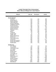
Tabel<br />
Table 1.1<br />
Luas Wilayah, Panjang Perbatasan, dan Panjang Pantai, 2006<br />
Mainland Area, Borderlines Length, and Coastline Length, 2006<br />
Jenis Data/Type <strong>of</strong> Data<br />
Jumlah/Total<br />
1. Luas Daratan/Land (km 2 ) 1 910 931,32<br />
2. Luas Pulau Besar/Big Islands (km 2 )<br />
a. Bali-NTB-NTT 73 070,48<br />
b. Jawa/Java 129 438,28<br />
c. Kalimantan 544 150,07<br />
d. Maluku-Papua 494 956,85<br />
e. Sulawesi 188 522,36<br />
f. Sumatera 480 793,28<br />
3. Luas Laut/Sea (km 2 )<br />
a. Laut Teritorial/Territorial Sea 284 210,90<br />
b. Zone Ekonomi Eksklusif 2 981 211,00<br />
Exclusive <strong>Economic</strong> Zone<br />
c. Laut 12 Mil/12 Miles Sea 279 322,00<br />
4. Panjang Perbatasan Dengan Negara Lain (km)<br />
Borders With Other Countries (km)<br />
a. Papua-Papua Nugini di Papua 820,00<br />
Papua-Papua Nugini in Papua<br />
b. Kalimantan-Malaysia di Kalimantan 2 004,00<br />
Kalimantan-Malaysia in Kalimantan<br />
c. NTT-Timor Leste di Timor 269,00<br />
NTT-Timor Leste in Timor<br />
5. Panjang Garis Pantai/Coastline Length (km) 104 000,00<br />
Sumber: Badan Koordinasi Survey dan Pemetaan Nasional<br />
Source: National Survey and Mapping Coordination Agency<br />
Perkembangan Beberapa Indikator Utama Sosial-Ekonomi <strong>Indonesia</strong>, Agustus 2012<br />
3