jura tourisme jura bernois tourisme - Tomas
jura tourisme jura bernois tourisme - Tomas
jura tourisme jura bernois tourisme - Tomas

Create successful ePaper yourself
Turn your PDF publications into a flip-book with our unique Google optimized e-Paper software.
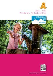
Canton du <strong>jura</strong> et <strong>jura</strong> <strong>bernois</strong><br />
sentiers pédestres<br />
WAnderWeGe<br />
HiKinG trAiLs<br />
Comment est produit l’éco-courant?<br />
Wie wird Ökostrom gemacht?<br />
Le long du Sentier découverte de 4 km qui relie la centrale solaire<br />
de Mont-Soleil au parc éolien de Mont-Crosin, vous trouverez de<br />
précieuses informations sur le thème de la nature et des nouvelles<br />
énergies. Vous pouvez aussi participer à une visite guidée. Informations<br />
et inscriptions: 0844 121 123, info<strong>jura</strong>@bkw-fmb.ch<br />
Auf dem 4 km langen Erlebnispfad – vom Sonnenkraftwerk Mont-<br />
Soleil bis zum Windpark Mont-Crosin – erfahren Sie alles zum<br />
Thema Energie und Natur. Oder Sie nehmen an einer geführten Besichtigung<br />
teil. Informationen und Anmeldung unter: 0844 121 123,<br />
info<strong>jura</strong>@bkw-fmb.ch<br />
www.bkw-fmb.ch<br />
Pub_CartePédestreJUTourisme_105x210mm_DE.ai 1 21.10.2011 15:51:07<br />
En vente dans tous les commerces spécialisés.<br />
Bon à savoir:<br />
• Visite guidée de la production du couteau suisse<br />
• Horaire du magasin d'usine: du lundi au vendredi: 9h-12h et 13h30-17h30<br />
Wenger SA - Route de Bâle 63 - Delémont - 032 421 39 00 - www.wenger.ch<br />
m<br />
3'500<br />
3'250<br />
3'000<br />
2'750<br />
2'500<br />
2'250<br />
2'000<br />
1'750<br />
1'500<br />
1'250<br />
1'000<br />
750<br />
500<br />
250<br />
0<br />
Enges<br />
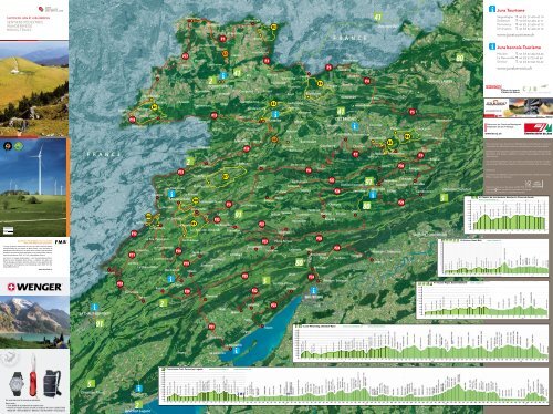
2 Trans Swiss Trail, 2 Trans Porrentruy-Lugano Swiss Trail, Porrentruy-Lugano (1/5)<br />
(1/5)<br />
0 5 10<br />
3'500<br />
3'250<br />
3'000<br />
2'750<br />
2'500<br />
2'250<br />
2'000<br />
1'750<br />
1'500<br />
1'250<br />
1'000<br />
750<br />
500<br />
250<br />
0<br />
15 20 0 25 5 10 30 15 35 20 40 25 45 30 50 35 55 40 60 45 65 50 70 55 75 60 80 65 85 70 90 75 95 80 85 90 95<br />
km<br />
km<br />
Porrentruy, 424m<br />
Champs Graitoux, 488m<br />
Les Chainions, 884m<br />
m<br />
Seleute, 640m<br />
St-Ursanne, 438m<br />
Porrentruy, 424m<br />
Fähre<br />
Champs<br />
Tariche,<br />
Graitoux,<br />
449m<br />
488m<br />
La Charbonnière, 455m<br />
Les Chainions, 884m<br />
Soubey, Seleute, 476m 640m<br />
St-Ursanne, Moulin Jeannottat, 438m 494m<br />
Les Pommerats, 903m<br />
Fähre Tariche, 449m<br />
Saignelégier, 982m<br />
Muriaux, 962m<br />
La Charbonnière, 455m<br />
Les Emibois, 955m<br />
Le Roselet, 1052m<br />
Soubey, Les 476mBreuleux,<br />
1038m<br />
Moulin Jeannottat, 494m<br />
Mont Soleil, 1256m<br />
Les Pommerats, 903m<br />
St-Imier, 815m<br />
Saignelégier, 982m<br />
Sonvilier, 803m<br />
Muriaux, 962m<br />
Les Emibois, 955m<br />
Le Le Roselet, Bec à l'Oiseau, 1052m 1179m<br />
Pertuis, Les Breuleux, 1025m 1038m<br />
Les Vieux Prés, 1030m<br />
Chézard, 795m<br />
Mont Soleil, 1256m<br />
Engollon, 727m<br />
St-Imier, 815m<br />
Les Trois Bornes, 827m<br />
Sonvilier, 803m<br />
Neuchâtel, 431m<br />
Le Bec à l'Oiseau, 1179m<br />
Pertuis, 1025m<br />
Les Vieux Prés, 1030m<br />
Cudrefin, Chézard, 431m 795m<br />
La Sauge, Engollon, 430m727m<br />
Les Trois Bornes, 827m<br />
Neuchâtel, 431m<br />
Cudrefin, 431m<br />
La Sauge, 430m<br />
P33<br />
m<br />
3'500<br />
3'250<br />
3'000<br />
2'750<br />
2'500<br />
2'250<br />
2'000<br />
1'750<br />
1'500<br />
1'250<br />
1'000<br />
750<br />
500<br />
250<br />
0<br />
P34<br />
5 Jura-Höhenweg, Dielsdorf-Nyon 5 Jura-Höhenweg, (1/3) Dielsdorf-Nyon (1/3)<br />
91<br />
0 5 10<br />
3'500<br />
3'250<br />
3'000<br />
2'750<br />
2'500<br />
2'250<br />
2'000<br />
1'750<br />
1'500<br />
1'250<br />
1'000<br />
750<br />
500<br />
250<br />
0<br />
15 20 0 25 5 30 10 35 15 40 20 45 25 50 30 55 35 60 40 65 45 70 50 75 55 80 60 85 65 90 70 95 75100 80105 85 90 95 100 105<br />
km<br />
km<br />
Dielsdorf, 429m<br />
Regensberg, 593m<br />
Hochwacht, 849m<br />
m<br />
Baden, 378m<br />
Baldegg, 568m<br />
Dielsdorf, 429m<br />
Brugg, 341m<br />
Regensberg, 593m<br />
Hochwacht, 849m<br />
Linn, 581m<br />
Baden, 378m<br />
Baldegg, 568m<br />
Staffelegg, 621m<br />
Salhöhe, 782m<br />
Brugg, 341m<br />
Geissflue, 963m<br />
Linn, Burgweid, 581m 798m<br />
Froburg, 837m<br />
Hauenstein, 668m<br />
Staffelegg, Challhöchi, 621m 848m<br />
Belchenflue, 1036m<br />
Bärenwil, Salhöhe, 778m 782m<br />
Geissflue, 963m<br />
Tiefmatt, 818m<br />
Roggenflue, 993m<br />
Burgweid, 798m<br />
Balsthal,<br />
Froburg,<br />
489m<br />
837m<br />
Hauenstein, 668m<br />
Schwängimatt, 1000m<br />
Challhöchi, 848m<br />
Hällchöpfli, 1211m<br />
Belchenflue, 1036m<br />
Vorderi Schmidmatt, 1018m<br />
Bärenwil, 778m<br />
Tiefmatt, Oberbalmberg, 818m 1078m<br />
Weissenstein, 1279m<br />
Roggenflue, 993m<br />
Balsthal, 489mHasenmatt,<br />
1445m<br />
Schwängimatt, 1000m<br />
Obergrenchenberg, 1347m<br />
Hällchöpfli, 1211m<br />
Vorderi Schmidmatt, 1018m<br />
Oberbalmberg, 1078m<br />
Weissenstein, 1279m<br />
Hasenmatt, 1445m<br />
Obergrenchenberg, 1347m<br />
m<br />
m<br />
2'500<br />
2'250<br />
2'000<br />
1'750<br />
1'500<br />
1'250<br />
1'000<br />
750 750<br />
500 500<br />
250 250<br />
0 0<br />
Basel, 251m<br />
Basel, 251m<br />
Alschwil, 284m<br />
Alschwil, 284m<br />
m<br />
3'500<br />
3'250<br />
3'000<br />
2'750<br />
2'500<br />
2'250<br />
2'000<br />
1'750<br />
1'500<br />
1'250<br />
1'000<br />
750<br />
500<br />
250<br />
0 41 41 ViaJura Regio, Basel-Delémont (1/2)<br />
Nauwiller, 348m<br />
Nauwiller, 348m<br />
m<br />
3'500<br />
3'250<br />
3'000<br />
2'750<br />
2'500<br />
2'250<br />
2'000<br />
1'750<br />
1'500<br />
1'250<br />
1'000<br />
750<br />
500<br />
250<br />
Basel, 251m<br />
0<br />
Hagenthal, 367m<br />
Hagenthal, 367m<br />
Wessenberg, 529m<br />
Wessenberg, 529m<br />
Basel, 251m<br />
St. Jakob, 257m<br />
St. Jakob, 257m<br />
Münchenstein, 271m<br />
Münchenstein, 271m<br />
Oltingue, 399m<br />
Oltingue, 399m<br />
Aesch BL, 313mAesch<br />
BL, 313m<br />
Ruine Pfeffingen, Ruine 458m Pfeffingen, 458m<br />
0 0 5 5 10 10 15 15 20 20 25 25 30 30<br />
km km<br />
35 35 40 40 45 45 50 50 55 55<br />
Ferrette, 489m<br />
Ferrette, 489m<br />
m<br />
2'500<br />
2'250<br />
2'000<br />
1'750<br />
1'500<br />
1'250<br />
1'000<br />
750<br />
500<br />
250<br />
0<br />
Winkel, 566m<br />
Winkel, 566m<br />
Stellenberg, 706m<br />
Stellenberg, 706m<br />
Oberlarg, 515m<br />
Oberlarg, 515m<br />
Moutier, 529m<br />
Perrefitte, 566m<br />
Largwald, 734m<br />
Largwald, 734m<br />
Lucelle, 598m<br />
Lucelle, 598m<br />
Ziegelkopf, 753m<br />
Ziegelkopf, 753m<br />
www.tetedemoine.ch<br />
Découvrez les Franches-Montagnes...<br />
Entdecken Sie die Freiberge...<br />
www.les-cj.ch<br />
impressum<br />
<strong>jura</strong> <strong>tourisme</strong><br />
saignelégier<br />
delémont<br />
porrentruy<br />
st-Ursanne<br />
t. +41 (0) 32 420 47 70<br />
t. +41 (0) 32 420 47 71<br />
t. +41 (0) 32 420 47 72<br />
t. +41 (0) 32 420 47 73<br />
www.<strong>jura</strong><strong>tourisme</strong>.ch<br />
<strong>jura</strong> <strong>bernois</strong> <strong>tourisme</strong><br />
Moutier t. +41 (0) 32 494 53 43<br />
La neuveville t. +41 (0) 32 751 49 49<br />
st-imier t. +41 (0) 32 942 39 42<br />
www.<strong>jura</strong><strong>bernois</strong>.ch<br />
Vous trouverez tous les parcours détaillés dans les brochures et cartes en<br />
vente dans nos offices de <strong>tourisme</strong> ou directement sur nos sites internet.<br />
detaillierter informationen zu den parcours finden sie in den entsprechenden<br />
Broschüren und Karten, erhältlich in unseren tourismusbüros oder direkt<br />
über internet.<br />
You will find all detailed routes you need in guidebooks and maps on sale in<br />
every tourism office of our region or connect you directly with our web sites.<br />
Conception et réalisation : empreinte communication visuelle, Le noirmont<br />
photo : Jura <strong>bernois</strong> <strong>tourisme</strong><br />
imprimé en suisse sur du papier certifié FsC<br />
Copiright c Jura <strong>tourisme</strong> et Jura <strong>bernois</strong> <strong>tourisme</strong><br />
reproduction partielle ou complète interdite.<br />
91 Chemin du Jura <strong>bernois</strong>, Moutier-La Chaux-de-Fonds<br />
Cornecul, 1038m<br />
Moron, 1319m<br />
80 ViaJura, Basel-Biel (1/2)<br />
80 ViaJura, Basel-Biel (1/2)<br />
Nenzlingen, 472m<br />
Nenzlingen, 472m<br />
Blauen, 531m<br />
Blauen, 531m Zwingen, 340m<br />
Zwingen, 340m<br />
Laufen, 355m<br />
0 5 10 15 20 25 30 35 40 45 50 55 60 65<br />
km<br />
0 5 10 15 20 25 30 35 40 45 50 55 60 65<br />
km<br />
Laufen, 355m<br />
Nider Huggerwald, 532m<br />
Nider Huggerwald, 532m<br />
La Réselle, 479m<br />
Soyhières, 399m<br />
Rne de Béridier, 580m<br />
Charmoille, 518m<br />
Charmoille, 518m<br />
Souboz, 868m<br />
La Réselle, 479m<br />
Delémont, 428m<br />
Soyhières, 399m<br />
Courroux, 415m<br />
Rne de Béridier, 580m<br />
0 5 10 15 20 25 30 35 40 45 50 55 60 65<br />
km<br />
Sornetan, 842m<br />
Delémont, 428m<br />
Vicques, 452m<br />
Bellelay, 940m<br />
Courroux, 415m<br />
Rebeuvelier, 663m<br />
Sur Montbautier, 1134m<br />
Vicques, 452m<br />
Le Chalet, 1169m<br />
Tramelan, 915m<br />
Rebeuvelier, 663m<br />
Chalet Neuf, 1245m<br />
Mont Croisin, 1177m<br />
St-Imier (Mont Soleil), 1178m<br />
L'Assesseur, 1201m<br />
La Puce, 1053m<br />
Station de la Cibourg, 1035m<br />
La Jailletat, 1094m<br />
La Chaux-de-Fonds, 993m
Parcours 27 Di�cile<br />
Château du Löwenburg<br />
Hôtel / Hotel<br />
Légendes / Legende / Keys<br />
Camping / Zeltplatz / Camping<br />
restaurant / restaurant / restaurant<br />
place de pique-nique / picknick-stelle / picnic sites<br />
panorama<br />
site naturel / naturschauplatz / natur reserve<br />
réserve forestière / Waldreserve / protected forest<br />
Gare / Bahnhof / railway station<br />
Halte train / Zughalt / train stop<br />
Bus<br />
Funiculaire / seilbahn / Funicular<br />
Bateau / schiff / Boat<br />
district franc fédéral / eidgenössisch Jagdbanngebiet<br />
protected area<br />
Office du <strong>tourisme</strong> / Verkehrsbüro / tourist information<br />
Curiosité touristique sur ou à proximité du parcours<br />
touristische sehenswürdigkeit am oder nahe biem parcours<br />
place of interest on or near the trail<br />
parcours / route / route<br />
Boucle / Kreis / Loop<br />
Liaison / Verbindung / Connection