Rock Fall Risk Management in the Bohemian Switzerland National ...
Rock Fall Risk Management in the Bohemian Switzerland National ...
Rock Fall Risk Management in the Bohemian Switzerland National ...

You also want an ePaper? Increase the reach of your titles
YUMPU automatically turns print PDFs into web optimized ePapers that Google loves.
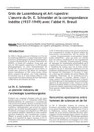
Z. Vařilová & J. Zvelebil <strong>Rock</strong> <strong>Fall</strong> <strong>Risk</strong> <strong>Management</strong> <strong>in</strong> <strong>Bohemian</strong> <strong>Switzerland</strong> <strong>National</strong> ParkFig.2: A. A map show<strong>in</strong>g <strong>the</strong> distribution of areas prone to creation dangerous rock falls with<strong>in</strong> <strong>the</strong> <strong>National</strong> Parkterritory. B. Inventory map of unstable rock objects endanger<strong>in</strong>g <strong>the</strong> Hřensko village with an assessment of <strong>the</strong>iractual <strong>in</strong>stability <strong>in</strong> a four-degree scale. C. An example of numerical evidence of <strong>in</strong>dividual unstable object <strong>in</strong>selected part with<strong>in</strong> <strong>the</strong> Hřensko village area.data process<strong>in</strong>g, and on-l<strong>in</strong>e, <strong>in</strong>teractive resultvisualizations has been <strong>in</strong>troduced.D) Different developmental stages of <strong>the</strong> processof rock fall preparation, <strong>in</strong>clud<strong>in</strong>g <strong>the</strong> earlywarn<strong>in</strong>g precursors of rock fall immediateoccurrence, are detected us<strong>in</strong>g characteristicdifferences <strong>in</strong> slope movement dynamics.Quite reliable diagnostics of immediate dangerstate (with read<strong>in</strong>g and evaluation <strong>in</strong>tervals <strong>in</strong>seconds), as well as its short and medium timeforecast<strong>in</strong>g (from days to 2 years) are at ourdisposal now (cf. Fig. 3; Zvelebil & Moser 2001).Phenomenological models, which are predom<strong>in</strong>antlyused for monitor<strong>in</strong>g data evaluationand rock fall danger assessment and whichhad been ma<strong>in</strong>ly empirically based (cf. Zvelebil1995, 1996), have been now accompany<strong>in</strong>g byma<strong>the</strong>matically rigorous numerical analysesand modell<strong>in</strong>g accord<strong>in</strong>g <strong>the</strong> latest challengesof complex dynamical systems <strong>the</strong>ory (Palušet al. 2004). For wider practical use of <strong>the</strong> laerand of <strong>the</strong>ir result visualisations, as well asfor improvement of implementation of <strong>the</strong>progressive <strong>in</strong>formation technologies enabl<strong>in</strong>git all, a four years project of establish<strong>in</strong>g andtest<strong>in</strong>g of <strong>the</strong> unique, highly automated expertsystem for safety evaluation of monitor<strong>in</strong>g datahas started <strong>in</strong> <strong>the</strong> <strong>National</strong> Park this year.Set of possible stabilis<strong>in</strong>g technologies has beenoptimised regard<strong>in</strong>g as monitor<strong>in</strong>g resultsand actual danger of rock fall occurrence andits possible negative consequences, and alsoas regard<strong>in</strong>g <strong>the</strong>ir economical and technicaldemands of each method <strong>in</strong> question withregards to demands of nature preservation.Two basic types of remedial technologies havebeen use <strong>the</strong>re:1) The simple one – which is possible to accomplishby hand-work, us<strong>in</strong>g technically verysimple and relatively cheap means. Specialposition with<strong>in</strong> <strong>the</strong> simple technologies holdsFerrantia • 44 / 200555
Z. Vařilová & J. Zvelebil <strong>Rock</strong> <strong>Fall</strong> <strong>Risk</strong> <strong>Management</strong> <strong>in</strong> <strong>Bohemian</strong> <strong>Switzerland</strong> <strong>National</strong> Parkmeasur<strong>in</strong>g sites were established. Frequency ofmanual read<strong>in</strong>gs is twice per month, and everyfive m<strong>in</strong>utes for <strong>the</strong> automatic ones. Emergencytechnical treatment had been given to 11 sites <strong>in</strong><strong>the</strong> 3 <strong>in</strong>troduc<strong>in</strong>g years of <strong>the</strong> system.Trial runs of <strong>the</strong> onl<strong>in</strong>e presentation of data havebeen launched. Information from an automaticdilatometric monitor<strong>in</strong>g is delivered on <strong>the</strong>website hp://www.geo-tools.cz; hp://www.geo-tools.cz; hp://www.geo-tools.cz; hp://www.geo-tools.cz; for <strong>in</strong>formationon manual dilatometry from <strong>the</strong> Hřensko villagearea visit <strong>the</strong> website hp://ig-exp.i-dol.cz.hp://ig-exp.i-dol.cz.F<strong>in</strong>ally, we would like to stress that an optimaldecision should be reached <strong>in</strong> an argumentationamong scientists, economists and decision-makersfrom politics and state adm<strong>in</strong>istration. Therefore<strong>the</strong> forms of clear, simple presentation of scientificdata are of outmost importance, o<strong>the</strong>rwise <strong>the</strong>gap between <strong>the</strong> practical decision makers andthose data providers cannot be still successfullybridged. This aspect of rock fall risk managementis also treated with<strong>in</strong> <strong>the</strong> frame of special project.AcknowledgementsOur long-term work was successively supportedby several grant projects. The project VaV 610/7/01of <strong>the</strong> M<strong>in</strong>istry of Environment of <strong>the</strong> CzechRepublic and <strong>the</strong> project No.T110190504 <strong>in</strong> <strong>the</strong>frame of an "Information Society Program" of <strong>the</strong>Academy of Sciences of <strong>the</strong> Czech Republic were<strong>the</strong> most recent ones.ReferencesPaluš, M., Novotná, D. & Zvelebil, J. 2004. - Fractalrock slope dynamics anicipat<strong>in</strong>g collapse. Phys.Review E, 70.Vařilová Z. 2002. - A review of selected sandstonewea<strong>the</strong>r<strong>in</strong>g forms <strong>in</strong> <strong>the</strong> <strong>Bohemian</strong> <strong>Switzerland</strong><strong>National</strong> Park, Czech Republic, <strong>in</strong> Přikryl R. &Viles H. (eds.), Understand<strong>in</strong>g and manag<strong>in</strong>g ofstone decay (SWAPNET 2001): 243-261, CharlesUniversity of Prague, The Karol<strong>in</strong>um Press,Prague.Vařilová Z. & Zvelebil J. 2005 (<strong>in</strong> pr<strong>in</strong>t). - Catastrophicand episodic events <strong>in</strong> sandstonelandscape: slope movements and wea<strong>the</strong>r<strong>in</strong>gissue, <strong>in</strong> Cílek V., Härtel H. & Herben, T. (eds.),Sandstone Landscapes / Treatise (ma<strong>in</strong> chapter- 18 pages).Zvelebil J. 1985. - Time prediction of a rock fall froma sandstone rock slope. Proc. 4th Int. Symp. onLandslides 3:93-96, Toronto.Zvelebil J. 1989. - Eng<strong>in</strong>ner<strong>in</strong>g geological aspectsof rock slope development <strong>in</strong> Děčín Highland,NW Bohemia (<strong>in</strong> Czech). PhD Thesis, CharlesUniversity, Prague.Zvelebil J. 1995. - Determ<strong>in</strong>ation of characteristicfeatures of slope movements prent day activityby monitor<strong>in</strong>g <strong>in</strong> thick-bedded sandstones of<strong>the</strong> <strong>Bohemian</strong> Cretaceous bas<strong>in</strong>. Acta UniversitatisCarol<strong>in</strong>ae, Geographica, Supp. 79-113,Praha.Zvelebil J. 1996. - A Conceptional PhenomenologicalModel to Stability Interpretaqtion ofDilatometric Data from <strong>Rock</strong> Slope Monitor<strong>in</strong>g,<strong>in</strong> Seneset K. (ed.), Landslides, Proc VII thInt.Symp. on Landslides: 1473-1480. Balkema,Roerdam.Zvelebil J. & Moser M. 2001. - Monitor<strong>in</strong>g BasedTime-Prediction of <strong>Rock</strong> <strong>Fall</strong>s: Three Case-Histories. Phys. Chem. Earth (b) 26,2:159-167.Zvelebil J. & Park H. D. 2001. - <strong>Rock</strong> SlopeMonitor<strong>in</strong>g for Environment – Friendly<strong>Management</strong> of <strong>Rock</strong> <strong>Fall</strong> Danger. Proc.UNESCO/IGCP Symposium «Landslide <strong>Risk</strong>Mitigation and Protection of Cultural andNatural Heritage», 15-19 January, Tokyo: 199-209.Zvelebil J. & Stemberk J. 2000. - Slope Monitor<strong>in</strong>g<strong>in</strong> Nature-Friendly of <strong>Rock</strong> <strong>Fall</strong> Danger fromSandstone <strong>Rock</strong> Walls <strong>in</strong> Děčín Highland, NWBohemia. Proc VIII thInt. Symp. on Landslides,Cardiff.Ferrantia • 44 / 200557
Z. Vařilová & J. Zvelebil <strong>Rock</strong> <strong>Fall</strong> <strong>Risk</strong> <strong>Management</strong> <strong>in</strong> <strong>Bohemian</strong> <strong>Switzerland</strong> <strong>National</strong> ParkRésumé da la présentationRisques géologiques dans un relief gréseux et possibilités de les réduire: gestion du risque dechutes de roches au parc naturel de la «Suisse de Bohème»Mots-clés: Grès; <strong>in</strong>stabilité de déblais de pente; chute de roche; évaluation et réduction de risque;réseau de surveillance; travaux réparateursLes grès stratifiés massifs à stratification subhorizontaled’âge Crétacé constituent le substrat rocheux du parcnational de la Suisse de Bohème (au nord-ouest de laBohême). Le relief propre au grès et la grande biodiversitéliée au relief, qui airent les touristes, vont de pairavec un risque élevé de chute de roche. Néanmo<strong>in</strong>s, leschutes de roches doivent être considérées comme partie<strong>in</strong>tégrante de l’évolution naturelle et actuelle des pentesdans le grès du parc. Pour dim<strong>in</strong>uer le risque pour lesgens et pour l’<strong>in</strong>frastructure, un système <strong>in</strong>tégré pour lagestion efficace du risque par chute de pierre, respectantla conservation de nature et nécessitant un aménagementraisonnable, a été présenté et se trouve en phase d’essai.La gestion débute par l’identification à l’échelle régionale(1:10.000) de zones à risque pour les chutes de rochesspécialement dans des endroits particuliers: dans lessecteurs peuplés, le long des voies de communicationset des pr<strong>in</strong>cipaux sentiers touristiques. Pour ces secteurson établit à l’échelle de 1:1000 et 1:2000, des cartesgéologiques pour <strong>in</strong>génieurs et un relevé des objets<strong>in</strong>stables. L’<strong>in</strong>stabilité de chaque objet <strong>in</strong>stable est classéede 1 à 4, en fonction de l’évolution de la pente dans letemps. Seuls les objets <strong>in</strong>contestablement et immédiatementdangereux subissent un traitement technique,sont stabilisés ou enlevés. Les autres sont surveillésaf<strong>in</strong> d’obtenir des <strong>in</strong>formations quantitatives sur lemouvement réel de la masse rocheuse et sur la c<strong>in</strong>ématiqueactuelle des glissement de terra<strong>in</strong>. Par cee surveillanceon dim<strong>in</strong>ue les <strong>in</strong>certitudes des données recueillieset on compense certa<strong>in</strong>s <strong>in</strong>convénients des approchesgeomécaniques de l’évaluation de la stabilité des pentesde roche. En conséquence, le nombre de demandesd’<strong>in</strong>terventions techniques a sensiblement dim<strong>in</strong>ué. Enfait, pour 90% des roches <strong>in</strong>stables de l’<strong>in</strong>ventaire, lasurveillance peut se substituer respectivement retarderpour des diza<strong>in</strong>es d’années les mesures réparatricestechniques.A côté des dilatomètres portatifs, des tiltmètres et desbandes extensométriques, un système automatique pourl’acquisition de données, un transfert à longue distance,la visualisation en ligne (Internet), et le stockage desrésultats la surveillance ont été récemment présentés.Les différentes étapes du processus de préparation d’unechute de roche, y compris la détection les précurseursimmédiats d’une chute, sont détectées en considérantles différentes caractéristiques de la dynamique dumouvement de pente. Le diagnostic tout à fait fiable del’état immédiat de danger (avec des <strong>in</strong>tervalles de lectureet d’évaluation toutes les secondes), aussi bien que sesprévisions à court et moyen terme (d quelques jours à 2ans) sont actuellement à notre disposition.Les modèles empiriques et phénoménologiques,jadis seuls, sont ma<strong>in</strong>tenant accompagnés d’analysesnumériques et de modèles tenant compte des théoriesrécentes de la dynamique des mouvements en pente.Particulièrement sur ce dernier po<strong>in</strong>t, un projet de quatreans a démarré cee année-ci au parc en vue d’établiret tester un système d’expertise unique et hautementautomatisé basé sur l’évaluation du risque à partir desdonnées de la surveillance.58 Ferrantia • 44 / 2005