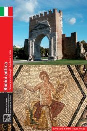
percorso 01 web ENG+FRA:Layout 1
percorso 01 web ENG+FRA:Layout 1
percorso 01 web ENG+FRA:Layout 1
- No tags were found...

You also want an ePaper? Increase the reach of your titles
YUMPU automatically turns print PDFs into web optimized ePapers that Google loves.
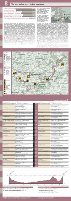
8The wine cellars’ tour - Le tour des cavesDistance/LongueurDifficulty/DifficultéOverall gradient/Dénivelée totaleUphill gradient/dén. en montéeDownhill gradient/dén. en descenteAsphalt stretches/parties asphalteDirt track stretches/parties terrain naturel varié36 km⋆⋆720 m360 m360 m16 km20 kmFrom Rimini head to Corianothen follow signs forS.Clemente. From Riccioneand Cattolica: head toMorciano di R. ten followsigns for S.Clemente.De Rimini, continuer pourCoriano, puis suivre lesindications pour S.Clement.De Riccione et de Cattolica,rejondre Morciano di R.,puis suivre les indicationspour S.Clemente.The itinerary begins outside the Malatesta walls on the north side. Itdescends initially on an asphalt road then a dirt track to S. Andrea in Casale.In Cà Togni it crosses the PR and continues towards the Conca River. It runsalong Via Pian di Vaglia towards the valley, alternating between stretches onasphalt and dirt track along Via Cerro as far as the ford on the river. Beforeit, turn left (beside the barrier) and continue along the dirt track then theasphalt road. Return along the river and beautiful paths through lush greeneryas far as the dam across the river. The itinerary continues along the leftbank before crossing the river on the AR bridge and returns to the cycle path.At a certain point, on the left side of the cycle path there are splendid golfcourses. The itinerary continues as far as the former mill in Pianventena. Itcrosses the road and returns to the cycle path that runs as far as Morciano diR. Near the stables, the itinerary returns to the PR where, on the left beforethe bridge, there is a water fountain. Just after the bridge at the roundaboutcyclists should follow signs for San Marino for about 100 metres and thenturn left into the middle of a small group of houses. A new cycle path beginswhich the itinerary leaves after about 2 km to return to a short stretch of PRbefore climbing Via Cà Menghi. There is a fountain at the top and a fewmetres from the fountain, the itinerary turns left and follows Via Panoramica.In Croce, it descends along the PR to San Savino. Here it turns right anddescends Via Veneto as far as Agello. Finally, there is a climb along an asphaltroad towards San Clemente, which leads back to the start.Le départ se fait du côté extérieur des murs malatestiens, versant nord.Descendre tout d’abord par la route asphaltée puis par une route en terre à S.Andrea in Casale, dans la loc. de Ca’ Togni, traverser la route départementaleet poursuivre en direction du fleuve Conca. Parcourir la via Pian di Vaglia dansla direction de la vallée, alternant des passages sur route asphaltée, piste puisde nouveau route asphaltée, le long de la via Cerro jusqu’au gué sur le fleuve.Tourner à gauche avant le gué (à côté de la barre) et parcourir la route en terre,puis asphaltée. Longer de nouveau le fleuve et suivre de très beaux sentiersverdoyants conduisant à la digue qui barre le cours du fleuve. Pédaler ensuitesur la digue gauche du fleuve, traverser ce dernier sur le pont de la nationaleet regagner la piste cyclable. A un certain point, sur le côté gauche de la piste,admirer les prés splendides d’un terrain de golf. Continuer jusqu’à l’ancienmoulin à huile de Pianventena; traverser la route et reprendre la piste cyclableconduisant à Morciano di R. A proximité d’un manège pour chevaux, reprendrela route départementale où, sur la gauche, avant le pont, se trouve une fontainepour remplir les gourdes. Tout de suite après le pont, au rond-point, suivrel’indication pour St. Marin pendant une centaine de mètres puis tourner àgauche au milieu d’un petit pâté de maisons. Prendre la piste cyclable etl’abandonner après environ 2 kilomètres; parcourir une partie de la routedépartementale et monter toute la via Ca’ Menghi, jusqu’à la fontaine. Tournerà gauche quelques mètres après cette fontaine et prendre la routePanoramique. Dans la loc. de Croce, descendre le long de la départementaledans la loc. de S. Savino. Tourner à droite et descendre dans la via Veneto puisrejoindre la loc. de Agello. Pour finir, monter le long de la route asphaltée endirection de S.Clemente et revenir au point de départ.key/légendeTAB tabletableauSx left gaucheDx right droiteM metres mètresKm kilometreskilomètresSS A-roadroute nationaleSP provincialroad routedépartementaleslm above sea levelsur le niveau de lamerdir straighttout droitste dirt trackterrasserasf asphaltasphalteSan Clementepanoramawatereauwood boisold villagebourgcastlechâteauchurch églisethermal spathermebarsrestaurantsTOWN/VILLAGENOTESTABKMLOCALITESNOTESitinerary/parcours 8S.Clemente/car park north sideat the bridgeVia Ca' TogniS. Andrea churchN.B. GROSSI wine cellar onthe rightbarrierleave riverat third gateunder A14 bridgeleave riverunder bridgehorse stablesroundaboutBilancioni Lakeleave cycle pathcrossroads (water fountain on left)San SavinoFattoria del PiccioneAgelloAt traffic lights strght for MorcianoLeft on Via degli Olivithen follow dt downhillRight on dt after 100 m strghtalong path through fieldsLeft on dtRight on Via ChiusuraLeft on asph downhill at the roundaboutstrght on Via CroceLeft on Via Ca' RenzinoRight downhillLeft on the bridgeFollow Via Pian di Vaglia first asphthen strght on pathRight on asph road downhillLeft on dt barrier at the sidethen follow asph Via FornaceRight on path strght riverRight on path along riverRight on path along riverLeft on river bankOn asph right, then right over bridgeRight on Via Po then on Via SavioLeft follow cycle pathFirst left on path then rightunder bridge on asphRight on cycle pathLeft on pathRight on cycle pathLeft on asph uphill then right on PRtowards bridgeStrght towards San MarinoLeft between the houses then right on cycle pathLeft on dt then follow cycle pathRight on asph roadLeft follow PRRight on Via Ca' Menghi uphillLeft on Via PanoramicaLeft on main asph roadRight on main asph road for CorianoRight on Via Veneto downhillLeft downhill then rightLeft downhillStrght on Via San SavinoRight for the centre of San Clemente1234567891<strong>01</strong>11213141516171819202122232425262728293031323334353637380,000,411,662,202,492,763,213,714,024,155,265,808,<strong>01</strong>9,3310,1911,4612,4612,8513,3414,3215,1416,1819,2623,0623,5823,7624,3626,4526,8227,3228,6229,3331,0932,9733,1933,5234,5436,30S.Clemente/Parking côté nordau pontvia Ca' Togniéglise S.AndreaN.B. sur la droite CantinaGROSSIbarresortie du fleuveau troisième portailsous le pont A.14sortie du fleuvesous le pontmanège (chevaux)rond-pointlac Bilancionisortir de la piste cyclablecroisement (à sx fontaine pour l’eau)San SavinoFerme del PiccioneAgelloau feu tt droit pour Morcianoà sx prendre via degli Olivi puis suivresent en descenteà dx sur sent après 100 m tt droitsur sent dans les champsà sx sur sentà dx prendre via Chiusuraà sx sur asph en descente puisau rond-point tt droit v. Croceà sx prendre via Ca' Renzinoà dx en descenteà sx sur le pontsuivre via Pian di Vaglia d’abord asphpuis tt droit sur sentà dx sur asph en descenteà sx sur sent à côté de la barre,puis suivre asph via Fornaceà dx sur sent tt droit pour le fleuveà dx sur sent le long du fleuveà dx sur sent le long du fleuveà sx sur la digue du fleuvesur asph à dx, puis à dx sur le pontà dx prendre via Po puis via Savioà sx suivre la piste cyclabled’abord à sx sur sent puis à dxsous le pont sur asphà dx sur piste cyclableà sx du sentierà dx sur la piste cyclableà sx sur asph en montéepuis à dx sur la RD vers le ponttt droit direction St. Marinà sx entre les maisons puis à dx sur piste cyclableà sx sur sent puis suivre la piste cyclableà dx sur asphà sx suivre la RDà dx prendre via Ca' Menghi en montéeà sx prendre la route Panoramiqueà sx sur asph principaleà dx sur asph principale pour Corianoà dx pour Veneto en descenteà sx en descente puis à dxà sx en descentett droit prendre via S.Savinoà dx pour le centre de S.Clementehm200San Clemente185 mSan Clemente2000Km5 10 15 20 25 30 350Particular gradients/Pentes particulièresCa’ Menghi climb/Montée “Ca´ Menghi“ 3,7%-max 10%S.Clemente climb/Montée S. Clemente 6%-max 12%Travel notes/Notes de voyage• San Clemente castle/San Clemente Château• Morciano village/Morciano village• Ca’ Menghi panorama/Ca’ Menghi PanoramaMobile Accident Unit / Secours d’urgence 118 Fire Brigade / Pompiers 115