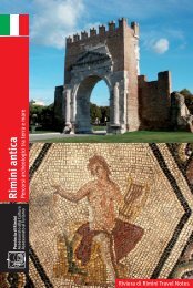
6The Onferno nature reserve - La réserve naturelle de OnfernoDistance/LongueurDifficulty/DifficultéOverall gradient/Dénivelée totaleUphill gradient/dén. en montéeDownhill gradient/dén. en descenteAsphalt stretches/parties asphalteDirt track stretches/parties terrain naturel varié29,5 km⋆⋆⋆1.369 m686 m683 m8 km21,5 kmFrom Riccione and Cattolicahead to Morciano di R. thenfollow the Conca PR towardsMercatino Conca for about 4km.De Riccione et de Cattolicarejoindre Morciano di R.Puis suivre la RD. du Concaen direction de Mercatino C.sur environ 4 km.STARTThe itinerary covers the municipality of Montecolombo, an ancient Roman town(Castrum Montis Colombi). It begins in the car park on the PR in Osteria Nuovaand follows the road on the right (Via Colomba). After the bridge over the ConcaRiver, start to climb towards Montefiore as far as the junction (1.25 km). At 1.67km turn right on the dirt track then after a series of climbs and descents (3.95 km)head into the wood following the path and cross some fords. Out of the wood(8.09 km), at the junction turn right onto the Molino Rocchi road and at the junction(8.48 km) climb to Castelnuovo (10.95 km). With the entire route to be coveredon the right, the road continues to climb the crest of the hill as far asPiandicastello church (15.21 km). Top up with water at the fountain then get backon the dirt track towards the cemetery. A few metres before the cemetery, turnleft along the path that leads to the highest part of the itinerary (552 m asl). Fromhere, descend to Onferno Castle. Given the precarious state of the land we recommenddismounting. There are many attractions here as it is an area of outstandingnatural beauty. It is possible to visit the museum and grottoes mentioned byDante in his “Divine Comedy”. Continue on the asphalt stretch uphill then on thelong, straight descent as far as 19.87 km where the itinerary turns right, back ontothe dirt track. Follow the crest of the hill, keeping the village of Gemmano on yourright. A series of climbs and descents on hard, dusty terrain will test your bike. Theitinerary continues on asphalt (22.15 km). Turn left and follow the PR towardsGemmano as far as Via Conventaccio and after a short climb on a dirt track headdown to the valley floor following the path halfway up the hill, through lush greeneryto Carbognano church (26.47 km). There are spectacular views of the valleyfrom here and the arrival point is nearby. This stretch is asphalt and the fastdescent ahead leads back to the bridge over the River Conca and continuing asfar as the crossroads and turning left leads back to Osteria Nuova.Nous sommes sur le territoire de la commune de Montecolombo, localité aux anciennes originesromaines (Castrum Montis Colombi). Le tour part du parking sur la route départementale(localité de Osteria Nuova) et, suivant la petite route à droite (via colomba) et après avoirdépassé le pont sur le fleuve Conca, commence à monter jusqu’au croisement en direction deMontefiore (km 1,25). Arrivés au km 1,67, tourner à droite sur une route en terre; une courtepartie vallonnée débouche à l’entrée du bois (km 3,95). Pénétrer à l’intérieur suivant le sentierprésentant quelques gués. A la sortie (km 8,09), au croisement prendre à droite la route pourMolino Rocchi et au croisement (km 8,48 ) remonter vers le village de Castelnuovo (km 10,95).La route continue de monter sur la crête offrant sur la droite tout le panorama du parcours àaffronter jusqu’à l’église de Piandicastello (km 15,21). Remplir les gourdes à la petite fontaineet reprendre la randonnée sur la petite route en terre en direction du cimetière. Quelquesmètres avant, tourner à gauche, le sentier portera au point le plus haut du parcours (alt. 552m). De là-haut commence la descente arrivant au-dessous du château de Onferno. Vu la difficultédu terrain, il est conseillé de descendre du vélo dans certains points. Cette zone offre plusieursattraits, il ne faut pas oublier que nous nous trouvons dans une zone naturaliste particulièreoffrant la possibilité de visiter le musée et les célèbres grottes citées par Dante Alighieridans la ''Divine Comédie''. Continuer sur une partie asphaltée en montée puis se lancer dansune longue descente sans virages jusqu’au km 19,87 pour reprendre le chemin en terre sur ladroite. Suivre la crête de la colline prenant pour référence le village de Gemmano sur notredroite. De continuels vallonnements sur un terrain dur et poussiéreux mettront vos vélos à rudeépreuve jusqu’à la reprise de la route asphaltée (km 22,15). Tourner à gauche et suivre la routedépartementale en direction de Gemmano, rejoignant ''via Conventaccio'' et, après unecourte montée en terre, commencer à descendre vers le fond de la vallée en suivant le sentierverdoyant à mi-côte qui débouche sur la petite église toute blanche de Carbognano (km 26,47). De ce point, la vue s’ouvre sur le fond de la vallée, la fin du parcours se trouvant à quelquesminutes de cette hauteur. La route est de nouveau asphaltée, la descente rapide devant nousnous ramène sur le pont du fleuve Conca et de là, nous continuons jusqu’au croisement entournant à gauche. Nous voici de nouveau à Osteria nuova.key/légendeTAB tabletableauSx left gaucheDx right droiteM metres mètresKm kilometreskilomètresSS A-roadroute nationaleSP provincialroad routedépartementaleslm above sea levelsur le niveau de lamerdir straighttout droitste dirt trackterrasserasf asphaltasphaltepanoramawatereauwood boisold villagebourgcastlechâteauchurch églisethermal spathermebarsrestaurantsTOWN/VILLAGENOTESTABKMLOCALITESNOTESitinerary/parcours 6Osteria Nuova/Week Endrest. car parkcement fordsmall fordopen fieldsmall fordsmall fordCastelnuovoPiandicastello churchOnferno Cavessmall chapelVia Case di Soprabefore the farmCarbognanoPR crossroadsOsteria Nuova/roundaboutFor Morciano at roundaboutright towards S. PietroRight on the bridgeLeft for Montefiore ConcaRight on dtStrght uphill on the pathLeft on the secondary pathLeft on the path through the woodRight then immediately leftRightRight on the main dtRight on the main dt uphillRight on the main dt uphillRight on the dtRight on the path downhillLeft on the main asph roadRight on the main pathLeft on the path uphillRight on the path uphillLeft on the main asph roadRight on the main asph roadLeft on asph then after 100 mLeft again on dtRight on the pathLeft on asph downhill then left on dt then asphLeft on the path downhillLeft on the main pathLeft on asphLeft over the bridgeLeft towards San MarinoStrght then right into the car park1234567891<strong>01</strong>11213141516171819202122232425262728290,000,451,251,673,954,925,106,847,158,098,4810,9515,2115,9117,5819,8720,6221,2722,1522,8823,8824,6025,1725,8326,0526,4728,8029,2629,62Osteria Nuova/parking restWeek Endgué en cimentpetit guéplein champpetit guépetit guéCastelnuovoéglise Piandicastellogrottes de Onfernopetite chapelleVia Case di Sopraavant la fermeCarbognanocroisement RDOsteria Nuova/rond-pointpour Morciano au rond-pointà dx pour S. Pietroà dx sur le pontà sx pour Montefiore Concaà dx sur senttt droit en montée sur sentà sx sur sentier secondaireà sx sur sentier dans le boisà dx puis tout de suite après à sxà dxà dx sur sent principalà dx sur sent principal en montéeà dx sur sent principal en montéeà dx sur sentà dx sur sent en descenteà sx sur asph principaleà dx sur sent principaleà sx sur sentier en montéeà dx sur sentier en montéeA sx sur asph principaleà dx sur asph principale, à sx aur asph puisaprès 100 m.à sx sur sentà dx sur sentà sx sur asph en descente pet à sx sur sent et puis asphà sx sur sentier en descenteà sx sur sentier principalà sx sur asphà sx sur le pontà sx pour St.Marintt droit puis à dx dans le parkinghm600Osteria NuovaBoscoPiandicastello480 mOnfernoOsteria Nuova6004004002002000Km 2 4 6 8 10 12 14 16 18 20 22 24 26 280Particular gradients/Pentes particulièresCastelnuovo climb/Montée pour Castelnuovo 5%Onferno descent/Descente pour Onferno 10,5% max 19%Carbognano descent/Descente pour Carbognano 11% max 27%Travel notes/Notes de voyage• Montecolombo Fortress/Montecolombo Forteresse• Montescudo Fortress/Montescudo Forteresse• Onferno caves/Onferno GrottesMobile Accident Unit / Secours d’urgence 118 Fire Brigade / Pompiers 115
7Cycling between the hills and the coast - Pédalant entre les collines et la côteDistance/LongueurDifficulty/DifficultéOverall gradient/Dénivelée totaleUphill gradient/dén. en montéeDownhill gradient/dén. en descenteAsphalt stretches/parties asphalteDirt track stretches/parties terrain naturel varié40,81 km⋆⋆⋆1.211 m609 m605 m22 km18 kmFrom Misano A. and Cattolicahead to the old bridge on theRiver Conca. Climb to the villageof Montalbano, the parkis on the right near the river.De Misano A. et de Cattolicagagner le Vieux Pont sur lefleuve Conca. Monter auhameau de Montalbano, leparc se trouve à droite, prèsdu fleuveMontalbanoThe itinerary begins near Cattolica in Montalbano Park, a natural balcony overlookingthe coast that offers spectacular views of the entire Riviera. It starts witha downhill stretch towards the dam on the River Conca where it joins the cyclepath along the river as far as the former mill in Pianventena. From the square,it follows the asphalt road to the crossroads with Via Vallette and after about 1km passes beside the Tempio Antico Estate. It continues on Via Conca Nuovatowards the old town centre of San Giovanni in M. whose history is strictlylinked to the great productivity and fertility of these lands, earning it the nameof the “Breadbasket of the Malatesta”. From here, the itinerary heads toMontelupo hill where it is possible to admire the vineyards and cellars of theMonsignore Estate. Turning back towards the coast the itinerary crosses wheat,sunflower and alfalfa fields. Next to Fanano Hill, it is possible to admire GradaraCastle, a fine example of 12th century military architecture and our next stop.The itinerary enters Gradara fortress through the main entrance on the southside and exits by a path on the north side, which leads to the valley floor alongsidethe A14 motorway. In Colombarone on the AR 16, head uphill along pathno. 2 of Monte San Bartolo Natural Park. At the top, near the bar, turn onto anarrow path that begins with some cement steps, passes through fields ofSpanish broom and opens onto spectacular panoramic views of the Riviera ofRomagna with cliffs dropping sheer to the sea. Descend again amid Spanishbroom and along some asphalt stretches to a narrow path in the woods thatleads to Vallugola Bay, a sandy beach with a small harbour. Return to the PRthat leads to Gabicce Monte and then to Cattolica, first along the AR 16 thenfollowing short stretches of cycle path along the Conca River back toMontalbano Park.Le tour commence dans le parc de Montalbano situé sur une terrasse naturelle,dans la première partie de l’arrière-pays de Cattolica, celui-ci offrant un splendidepanorama sur toute la rivière. Partir en descendant vers la digue du fleuve Concaet prendre la piste cyclable qui côtoie le fleuve jusqu’à l’ancien moulin à huile dePianventena; de la place, suivre la route asphaltée jusqu’au croisement avec la viaVallette et, après environ 1 Km, passer devant le domaine du «Tempio antico».Prendre la via Conca Nuova en direction du centre historique de S.Giovanni in M.,dont l’histoire est étroitement liée à la grande productivité de ses terres, fertilesau point de se mériter l’épithète de «Grenier des Malatesta». De S. Giovanni, sediriger sur la colline de Montelupo avec ses splendides cultures de vignes et lescaves de la «Tenuta del Monsignore». Revenant vers la côte, traverser les champsde blé, de tournesols et de luzerne, admirant, derrière la colline de Fanano, la forteressede Gradara, magnifique exemple d’architecture militaire du XIIe siècle,notre destination suivante. A Gradara, traverser la forteresse entrant par la porteprincipale, côté sud, et sortant par un sentier, côté nord, qui conduit au fond dela vallée et longe l’autoroute A.14. Une fois dans la localité de Colombarone, surla RN S.S. n°16, monter sur la colline par le sentier n°2 du Parc naturel du MonteS.Bartolo; au sommet, à proximité du bar, prendre un étroit sentier qui commencepar des marches en ciment, passe au milieu des genêts et débouche surun magnifique panorama à pic sur la mer qui offre un aperçu extraordinaire de larivière romagnole. Descendre encore parmi les genêts et après quelques partiesde route asphaltée, prendre un sentier au milieu du bois conduisant à BaiaVallugola, avec sa petite plage et son port. Reprendre la route départementalequi porte à Gabicce Monte, et de là revenir à Cattolica, suivant tout d’abord laRN S.S. n°16 puis une courte portion de piste cyclable le long du fleuve Concajusqu’au parc de Montalbano.key/légendeTAB tabletableauSx left gaucheDx right droiteM metres mètresKm kilometreskilomètresSS A-roadroute nationaleSP provincialroad routedépartementaleslm above sea levelsur le niveau de lamerdir straighttout droitste dirt trackterrasserasf asphaltasphaltepanoramawatereauwood boisold villagebourgcastlechâteauchurch églisethermal spathermebarsrestaurantsTOWN/VILLAGENOTESTABKMLOCALITESNOTESitinerary/parcours 7Montalbano Park, Cattolicagolf courseformer millVia ValletteTempio Antico EstateVia Conca NuovaroundaboutroundaboutVia ColombarinaMonsignore wine cellarsVia PietrafittaVia Mosca MonteloraVia Valle del Picchiosmall chapelsuburbs of Gradaraentrance to castleVia Dante AlighieriBritish war cemeteryAR no. 16no thoroughfare signPanoramica roadbarpanoramic squarePanoramica roadPanoramica roadVallugola BayPanoramica roadGabicce M. churchenter AR no. 16leave AR no. 16Via Poafter underpassLeft then strght after 250 mLeft path alongside the fenceRight under the bridgeRight follow cycle pathKeep left - beware of the landslideLeft leave cycle path for dtLeft on asphStrght on main asphRightLeftRight under the flyoverLeft then right for the centreStrght for UrbinoRight for MontelupoLeftLeftLeft then at the roundabout strghtRight on secondary asphLeftStrght on dtStrght on asph downhill then dtRight uphillLeft for the centre then the castleLeft - water fountain on the rightRight along the town wallsRight downhill on pathRight on asphRight on asph then alongside A14Left then right after bridgeLeft towards PesaroRight towards PesaroLeft for Casteldimezzo then path 2 - SanBartolo ParkLeft uphillRightLeft on the cement stepsLeft on main pathRight downhillRight on dt then after 300 m left onnarrow pathRight on asph then after 50 m left on dtLeft on asph uphillRightLeft follow signs for AR 16Left then right towards RiminiRight follow signs for CattolicaRight then on Via Savioleft on cycle pathleft on path uphill1234567891<strong>01</strong>11213141516171819202122232425262728293031323334353637383940414243444546470,000,600,730,942,575,646,007,128,248,979,339,6910,0<strong>01</strong>0,3510,7511,5811,8612,8613,9614,6<strong>01</strong>5,9117,6<strong>01</strong>8,2519,1119,2119,4419,8120,5021,2822,3923,3523,7024,6425,2725,5425,6526,1026,9027,3928,3328,7331,1733,0038,6439,4039,6039,88parc Montalbano Cattolicaterrain de golfancien moulin à huilevia Vallettedomaine Tempio Anticovia Conca Nuovarond-pointrond-pointvia Colombarinacaves del Monsignorevia Pietrafittavia Mosca Monteloravia Valle del Picchiopetite chapellepériphérie de Gradaraentrée du châteauvia Dante Alighiericimetière des AngalisRN S.S. n°16panneau de passage interditroute Panoramiquebarplace panoramiqueroute Panoramiqueroute Panoramiquebaie Vallugolaroute Panoramiqueéglise de Gabicce M.entrée sur la RN S.S. n°16sortie de la RN S.S. n°16via Poaprès le passage souterrainà sx puis tt droit après 250 m.à sx sentier longeant la clôtureà dx sous le pontà dx suivre la piste cyclablegarder la sx – attention aux éboulementsà sx laisser la piste cyclable pour le sentà sx asphtt droit sur asph principaleà dxà sxà dx sous le saut-de-moutonà sx puis à dx pour le centrett droit pour Urbinoà dx pour Montelupoà sxà sxà sx puis au rond-point tt droità dx sur asph secondaireà sxtt droit sur le senttt droit sur asph en descente puis sentà dx en montéeà sx pour le centre puis pour le châteauà sx – fontaine pour les gourdes sur la dxà dx côtoyer la murailleà dx en descente sur sentà dx sur asphà dx sur asph puis côtoyer l’A14à sx puis à dx après le pontà sx pour Pesaroà dx pour Pesaroà sx pour Casteldimezzoet suivre RN 2-Parc S. Bartoloà sx en montéeà dxà sx sur escaliers en cimentà sx sur sentier principalà dx en descenteà dx sur sent puis après 300.m à sxsur sent étroità dx sur asph puis après 50 m à sx sur sentà sx sur asph en montéeà dxà sx suivre la direction RN S.S. n°16à sx puis à dx pour Riminià dx prendre direction Cattolicaà dx puis dans la via Savioà sx sur piste cyclableà sx sur sentier en montéehm400MontalbanoFrantoioS.Giovanni in M.S.Maria in PietrafittaGradaraMonte S.BartoloBaia VallugolaGabicceSS16Montalbano400240 m2002000Km 5 10 15 20 25 30 35 400Particular gradients/Pentes particulièresGradara climb/Montée Gradara 4,2%-max 10%Gradara descent/Descente Gradara 6,5%-max 13%M. S. Bartolo climb/Montée M. S. Bartolo 7,2%-max 20%Vallugola descent/Descente Vallugola 6,9%Travel notes/Notes de voyage• San Giovanni in Marignano village/San Giovanni in M. village• Gradara Castle/Gradara Château• Monte San Bartolo panorama/Monte San Bartolo Panorama• Monte San Bartolo Park/Monte San Bartolo ParcMobile Accident Unit / Secours d’urgence 118 Fire Brigade / Pompiers 115