percorso 01 web ENG+FRA:Layout 1
percorso 01 web ENG+FRA:Layout 1
percorso 01 web ENG+FRA:Layout 1
- No tags were found...

Create successful ePaper yourself
Turn your PDF publications into a flip-book with our unique Google optimized e-Paper software.
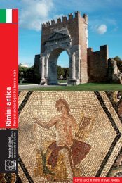
12From the Marecchia Valley to San Leo Fortress - De la vallée du Marecchia à la forteresse de San LeoDistance/LongueurDifficulty/DifficultéOverall gradient/Dénivelée totaleUphill gradient/dén. en montéeDownhill gradient/dén. en descenteAsphalt stretches/parties asphalteDirt track stretches/parties terrain naturel varié22 km⋆⋆1.087 m542 m545 m8 km14 kmPietracuta is on theMarecchiese AR,20 km from Rimini.Pietracuta est sur la routenationale Marecchiese, à 20km de RiminiThis itinerary starts in Pietracuta, from the car park on the MarecchiesePR, on the road to San Leo. A short distance after the bar/petrol stationand the crossroads, leave the asphalt road and turn right along a cartroad. This leads to the crest of the hill in Case Belvedere. On asphalt,the road climbs to Tausano. The itinerary continues on a dirt track thatafter a few km reaches a junction of roads and paths that head in alldirections. Bear right on the rocky dirt track and follow it as far as thenext crossroads. Climb left on the crest. Turn right and follow the spectacularpath as for as the crosses on Monte S. Severino then head downhillto San Leo cemetery. On asphalt, head into the heart of the village.On the old paved road it is possible to climb up to the fortress. For thereturn journey, once out of the village, head downhill on the asphaltroad towards Secchiano/Novafeltria and after a km turn right along asmall path half hidden by shrubs. Over the hill stands the 13th century,Franciscan monastery of S. Igne. Head down the dirt track just belowthe monastery as far as the Marecchia River in the village of Ponte S.Maria Maddalena. Continue for a few metres along the AR 258 asphaltroad towards Rimini and then turn right on a disused asphalt road for afew km as far as the initial road. A few km and the itinerary is back at thedeparture point.Le tour part de Pietracuta, du parking parallèle à la RN Marecchiese, surasphalte, en direction de S. Leo. Après le bar/poste d’essence, dépasserle croisement puis laisser l’asphalte après quelques dizaines demètres et tourner à gauche dans un chemin charretier. Rejoindre la crêteau lieu-dit Case Belvedere. Monter, sur asphalte, jusqu’à Tausano. Suivreensuite une route en terre conduisant, après quelques kilomètres, au«Varco», croisement de chemins et de sentiers qui rayonnent à 360°.Prendre à droite la piste accidentée en terre et la suivre jusqu’au croisementsuccessif. Monter à gauche et rejoindre la crête. Prendre à droitele splendide sentier jusqu’aux croix du mont S. Severino et descendreau cimetière de S. Leo. Rejoindre le centre de S. Leo, sur asphalte. Uneancienne route pavée permet de monter jusqu’à la forteresse. Pour leretour, une fois sortis du village, prendre la route asphaltée en directionde Secchiano/Novafeltria et, après un kilomètre, tourner à droite dansun petit sentier en partie caché par les arbustes. Après le coteau, ildébouche devant le couvent franciscain du XIIIe siècle de S. Igne.Descendre par la route en terre qui passe juste sous le couvent et, suivantune rapide descente, initialement blanche puis accidentée, rejoindrele fleuve Marecchia dans la localité de Ponte S. Maria Maddalena.Parcourir quelques mètres sur asphalte le long de la RN 258 en directionde Rimini, puis prendre à droite une ancienne route asphaltée abandonnéequi débouche après un kilomètre sur la route asphaltée dudépart. Un kilomètre encore et voilà de nouveau le point de départ.key/légendeTAB tabletableauSx left gaucheDx right droiteM metres mètresKm kilometreskilomètresSS A-roadroute nationaleSP provincialroad routedépartementaleslm above sea levelsur le niveau de lamerdir straighttout droitste dirt trackterrasserasf asphaltasphaltepanoramawatereauwood boisold villagebourgcastlechâteauchurch églisethermal spathermebarsrestaurantsTOWN/VILLAGENOTESTABKMLOCALITESNOTESitinerary/parcours12Case BelvedereTausanoTausanoIl varcoSan LeoS. IgneS. IgnePonte S.Maria MaddalenaPietracutaLeft about 1 kmLeft about 1 kmLeft about 1 kmTwo signs: left S.Leo, right S.IgneSx about 2 kmTwo signs: left Ponte S.Maria M.,right S.IgneTwo signs: left Ponte S.mariaSx obout km 1,5<strong>01</strong>234567891<strong>01</strong>112131415161717A181919A19B2021222324250,000,200,650,751,2<strong>01</strong>,702,202,603,103,605,506,106,707,407,557,808,008,3<strong>01</strong>1,3<strong>01</strong>2,2<strong>01</strong>3,1<strong>01</strong>3,3<strong>01</strong>3,5<strong>01</strong>4,0<strong>01</strong>7,5<strong>01</strong>8,5<strong>01</strong>8,8<strong>01</strong>9,4020,50Case BelvedereTausanoTausanocroisement du VarcoSan LeoS. IgneS. IgnePonte S.Maria MaddalenaPietracutasx km 1 env.sx km 1 env.sx km 1 env.indications doubles: sx S.Leo, dx S.Ignesx km 2 env.indications doubles: sx Ponte S.Maria M.,dx S.Igneindications doubles sx Ponte S.mariasx km 1,5 env.hm800PietracutaTausanoLe Croci di M.S.SeverinoSan LeoS. IgnePonte S.M. MaddalenaPietracuta800600626 m60040040020020000-200Km2 4 6 8 10 12 14 16 1820-200Particular gradients/Pentes particulièresCase Belvedere climb/Montée pour Case Belvedere 12%Tausano descent (asfhalt)/Descente pour Tausano (asphalte) 12%Climb on the crest/Montée pour la crête 9% - max 15%Croci descent/Descente des Croix 14%Uphill stretch path for S.Igne/Partie en montée sentier pour S.Igne 15%Downhill stretch for S.Igne/Partie en descente sentier pour S.Igne 15%P. S. Maria M. descent /Descente pour P. S.Maria M. 7% - max 15%Travel notes/Notes de voyage• San Leo Fortress/San Leo forteresse• S.Igne Monastery/S.Igne couvent• Crosses on Monte S. Severino panoramaLe Croci M. S. Severino: panoramaMobile Accident Unit / Secours d’urgence 118 Fire Brigade / Pompiers 115