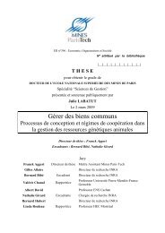
<strong>Architecture</strong> <strong>du</strong> <strong>bassin</strong> <strong>rhodano</strong>-<strong>provençal</strong> <strong>miocène</strong> (<strong>Alpes</strong>, SE France). - Annexes Annexe 33 : Une discussion de l’article de Siame et al. (2004) rédigé avec Olivier Parize et Bernard Beaudoin est présentée ici (ce commentaire n’a pas été retenu par l’éditeur de la revue). “Local erosion rates versus active tectonics: cosmic ray exposure modelling in Provence (south-east France)”, by Lionel Siame, Olivier Bellier, Régis Braucher, Michel Sébrier, Marc Cushing, Didier Bourlès, Bruno Hamelin, Emmanuel Baroux, Béatrice de Voogd, Grant Raisbeck, Françoise Yiou – comments. Abstract: Quantification of geological processes is a present day necessity and all innovative approaches are useful. The confidence in these quantified results will be provided by robust geological controls, integrated to the quantitative approaches. Our comment of a recently published Letter illustrates these demands. Key words: cosmogenic nuclides; Neogene; incised valley; eustatism; active faults; southeastern France Siame et al. [1] propose an innovative approach to better constrain in time active deformation in a low seismicity region. Their analysis is focused on two major oriented NNE-SSW faults, the Nîmes and Durance ones, which control sedimentation in SE France since Triassic up to present day. But weathering and anthropomorphic activities affect the geomorphic evidences of their neotectonic activities. The cosmogenic ray exposure modelling appears indeed as a very performing tool to quantify such an active deformation, and in a better way when the studied outcrops are replaced in their geological context that ancient and recent works have often detailed. It is what we offer to precise here, by some comments on that recent publication. 1. Middle Durance fault area Durance and Nîmes faults, associated with a series of parallel sister-faults (Cévennes, Col de la Cine, Var-Rouaine) are well known to have plaid a recurrent role in the location of depocenters along Mesozoic and Cenozoic [2]. Their Neogene expression corresponds to successions of faulted and folded areas, especially in the Manosque zone (Ref. in [1]). Beginning of alpine compressive effects f the Middle Durance Fault (MDF) is clearly normal <strong>du</strong>ring Oligocene [3], the alpine thrust propagation and the development of the perialpine flexural basin took place early in that area, <strong>du</strong>ring Lower Miocene, attested by in<strong>du</strong>strial seismic data showing the progressive onlapping of Miocene deposits from East to West, near the Durance river where Lower Miocene deposits are absent [4] and field investigations [5]. The basal Miocene basin unconformity is related to the flexural uplift and underlined by the Lower Miocene incised valley system (Besson and Parize in [5]). Geometry and age of the reference surfaces Using sedimentary surfaces related to the Upper Messinian well known incision and its Plio-Pleistocene infilling, Siame et al. [1] propose to quantify MDF vertical throw since -2 Myr. Precisely, they use as an isochronal and horizontal marker: the base of the conglomeratic unit of La Valette – Rancurel canyon (Ref. in [1, 5]). Firstly, such a surface cannot be taken as a smooth horizontal one; local morphologies are probable, especially on the flanks of the Messinian valley (it is the case of the Pigeonnier de l’Ange outcrop). Secondly, that surface is diachronous, linked to Plio-Pleistocene Durance piedmont progradation [6]. It would be better to use the top surface of the conglomerates, the abandonment surface of the fluvial piedmont, one of the main key surfaces defined by Clauzon (Ref. in [5]: Fig. 12). In fact the age of -2 Myr used by the authors [1] is precisely that of this abandonment surface proposed by Clauzon (ibid.) and not of the basal surface; at Pigeonnier de l’Ange, the conglomeratic unit was dated between -3.3 and -3 Myr [7] and recent calibrations suggest -4.9 Myr (Aguilar in [5]: Fig. 7c). On the topographic escarpment Exaggerated by vertical scale magnification ([1], their fig. 7), the topographic “escarpment” could benefit of a presentation and discussion of different hypothesis: possible MDF cropping, but also fitting of a paleo-Durance or differential compaction on the flank of a paleo-valley … 2. Bois de Clary terrace near the Rhône valley On the same way, the geological setting of the Bois de Clary area ([1], their Fig. 3) has to be clarified. 2.1. On the Miocene history Siame et al. [1] indicate, after Peulvast et al. (Ref. in [1]), that the Lower to Upper Miocene deposit would be confined into a fault graben corresponding to Pujaut basin. Our field investigations show an erosive stratigraphic contact between Neogene and its bedrock (Fig. 1, profiles BB’ and CC’) : the Lower Miocene deposits are now inverted and preserved at the top of Angles plateau whereas the Middle and Upper Miocene ones crop in the Pujaut and Villeneuve-lès-Avignon paleovalleys. Such a geometrical relation is clearly related to fluvial erosion enhanced by regional tectonic uplift [8]. The Bois de Clary terrace itself is strictly situated above the Messinian Rhône Canyon axis [9, 10]: the talweg base is here situated at a depth of more than –800m NGF (Fig. 1, profile BB’) underling the importance (Ref. in [9]) of the Messinian Salinity Crisis on the morphological and sedimentological history in SE France (and all Mediterranean surroundings) since -5.9 Myr [11, 12, 13]. 2.2. The organisation of the Plio-Pleistocene Rhône terraces Around Bois de Clary, the stepped organisation of the terraces may be related to: - Differential compaction above the Messinian canyon infill and lateral creeping to the Rhône valley, - Long wave regional tectonic linked to Massif Central uplift, eventually folding deformation by reactivation of Pyrenean movements, - High frequency sea level fluctuations recorded by successive fluvial aggradational stages since -3.8 Myr [14], - … 2.3 The age of the Bois de Clary conglomerates In such a context, the age of the glacis/terrace has to be discussed. Siame et al. [1] consider the Bois de Clary conglomerates as Villafranchian deposits, in stratigraphic equivalence of Saint-Vallier formation, dated –2 Myr (Ref. in [1]); such a correlation is for the moment doubtful because the Villafranchian unit corresponds to a patchwork of conglomeratic sheets without clear genetic relations between themselves and the Saint-Vallier loess deposits. In any case the Saint-Vallier loess lies on the Pliocene abandonment surface [9] and is not equivalent to. Annexes - 146 -
<strong>Architecture</strong> <strong>du</strong> <strong>bassin</strong> <strong>rhodano</strong>-<strong>provençal</strong> <strong>miocène</strong> (<strong>Alpes</strong>, SE France). - Annexes The mapping of Rhône terraces (Ref. in [1]) shows the superposition of Bois de Clary glacis/terrace on previous Pliocene deposits interpreted as Pliocene piedmont (Fig. 1: profile B – B’), whereas the younger terraces are nested and shifted to the east as results of aggradational epigenesis, certainly enhanced by tectonic. The age of that abandonment surface can be tentatively correlated with the -3.8 Myr sea level fall [14] in agreement with previous dating of the underlying fluvial deposits [9]; if the abandonment surface is composite, between -3.8 and -2 Myr. In any case this age is largely older than the proposed -1,2 Myr age [1]. 3. Conclusions Quantification of geological processes is a present day necessity and all innovative approaches are useful. The Siame et al. contribution [1] is an obvious source of progress in our knowledge. If our geological precisions don’t change the order of magnitude of their results, we hope that they will clarify the geological description and understanding of that SE France domain, specially for the non-initiated colleagues; on an other hand, a better geological control will always be source of confidence in quantified results. Fig. 1. Structural and geomorphic setting of Pujaut basin. Location of the area from [1]. A – A’: Location of the sketch geological profile proposed by Siame et al. ([1], their Fig. 3). B – B’ and C – C’, Geological profiles across Miocene paleovalleys: The Neogene deposits fill successive incised paleovalleys and the last and the deepest one, the Messinian Rhône canyon, is well informed by field analysis [9] and seismic data [10]. Annexes - 147 -