La gestion intégrée des eaux pluviales - AQUA-ADD Interreg IVC ...
La gestion intégrée des eaux pluviales - AQUA-ADD Interreg IVC ...
La gestion intégrée des eaux pluviales - AQUA-ADD Interreg IVC ...

You also want an ePaper? Increase the reach of your titles
YUMPU automatically turns print PDFs into web optimized ePapers that Google loves.
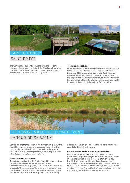
7<br />
PARC DE PARILLY<br />
SAINT-PRIEST<br />
The work carried out jointly by Grand Lyon and the park<br />
managers has allowed a solution to be found which satisfies<br />
the public’s expectations in terms of multifunctional space<br />
and the demands of rainwater management.<br />
The techniques selected<br />
Of the 3 basins built, the settling basin is the only one closed<br />
to the public. The retention basin stores rainwater and<br />
becomes a BMX course when it dries out. The infiltration<br />
basin is covered with an anti-contamination film to limit<br />
the migration of pollutants into the ground. Part of this basin<br />
has been made into a wetland area, to establish a new habitat<br />
for the amphibian populations of the Parc de Parilly.<br />
THE CONTAL MIXED DEVELOPMENT ZONE<br />
LA TOUR-DE-SALVAGNY<br />
Carried out prior to the <strong>des</strong>ign of the development of the Contal<br />
Mixed Development Zone, an urban environmental analysis<br />
revealed the highly specific topography of the development<br />
land. It has allowed a management system to be put in place<br />
which follows the natural course of water.<br />
Green rainwater management<br />
The rainwater network in the Contal Mixed Development Zone<br />
comprises drainage trenches topped with swales.<br />
Perpendicular to the slope, they hold back run-off water more<br />
effectively. Thanks to the roof terraces of the homes and the<br />
tanks in each city block, water from private plots discharges<br />
into this limited-flow network. To protect the soil from any<br />
accidental pollution, an anti-contamination geo-membrane<br />
carpets the base of the trenches.<br />
Grassed swales for the planted retention basins...<br />
Once in the swale, the water percolates into the ground,<br />
thereby reaching the drainage trench, and from there passes<br />
into the drain which carries it to the 3 retention basins.<br />
Installed in the centre of the mixed development zone,<br />
in the wetland area, they are supplied with rainwater and water<br />
from the Écurie source, located at the high point of the mixed<br />
development zone. The first basin always contains water while<br />
the following two take the overflow from the first.