Ecologia Mediterranea
Ecologia Mediterranea
Ecologia Mediterranea

You also want an ePaper? Increase the reach of your titles
YUMPU automatically turns print PDFs into web optimized ePapers that Google loves.
elong to two major geomorphological habitat<br />
types: small wadis that cut their way down<br />
djebel (mountain) slopes and large wadi beds<br />
in valleys at low altitude (800 to 1200 m).<br />
Climatic characteristics<br />
The Ahaggar is under the influence of two climatic<br />
regimes: a <strong>Mediterranea</strong>n regime from<br />
the north and a tropical one from the south.<br />
The climate of the study area is characterised<br />
by low and irregular rainfall (Daget & Djellouli<br />
1992). The mean annual rainfall calculated<br />
over a period of 63 years was 46.6 mm.<br />
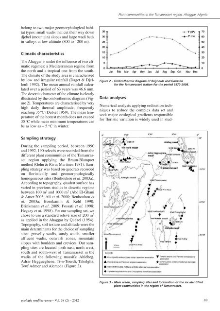
The desertic character of the climate is clearly<br />
illustrated by the ombrothermic diagram (Figure<br />
2). Temperatures are characterised by very<br />
high daily thermal amplitude, frequently<br />
reaching 35 o C (Dubief 1959). The mean temperature<br />
of the hottest month does not exceed<br />
35 o C while mean minimum temperatures can<br />
be as low as – 5 o C in winter.<br />
Sampling strategy<br />
During the sampling period, between 1990<br />
and 1992, 190 relevés were recorded from the<br />
different plant communities of the Tamanrasset<br />
region applying the Braun-Blanquet<br />
method (Gehu & Rivas Martinez 1981). Sampling<br />
strategy was based on quadrats recorded<br />
on floristically and geomorphologically<br />
homogeneous sites (Benhouhou et al. 2003a).<br />
According to topography, quadrat surface has<br />
varied in previous studies in desertic regions<br />
between 100 m 2 and 1000 m 2 (Abd El-Ghani<br />
& Amer 2003; Ali et al. 2000; Benhouhou et<br />
al. 2003a; Bornkamm & Kehl 1990;<br />
Brinkmann et al. 2009; Fossati et al. 1998;<br />
Hegazy et al. 1998). For our sampling set, we<br />
chose to use a standard relevé size of 200 m 2<br />
as applied in the Ahaggar by Quézel (1954).<br />
Topography, soil texture and altitude were the<br />
main determinants for the choice of sampling<br />
sites: gravelly wadis, sandy wadis, smaller<br />
affluent wadis, outwash zones, mountain<br />
slopes with boulders and crevices. Our sampling<br />
sites are located north-east, north-west,<br />
south and south-west of Tamanrasset in the<br />
wadis of the following massifs: Ahléheg,<br />
Adrar Heggueghene, Ti-n-Tourdi, Tahelgha,<br />
Touf Admer and Alemeda (Figure 3).<br />
ecologia mediterranea – Vol. 38 (2) – 2012<br />
Data analyses<br />
Plant communities in the Tamanrasset region, Ahaggar, Algeria<br />
Figure 2 – Ombrothermic diagram of Bagnouls and Gaussen<br />
for the Tamanrasset station for the period 1970-2008.<br />
Numerical analysis applying ordination techniques<br />
to reduce the complex data set and<br />
seek major ecological gradients responsible<br />
for floristic variation is widely used in stud-<br />
Figure 3 – Main wadis, sampling sites and localisation of the six identified<br />
plant communities in the region of Tamanrasset.<br />
69