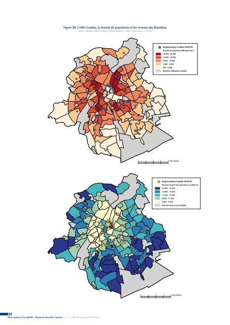
44 Observatoire <strong>de</strong> la mobilité - <strong>Région</strong> <strong>de</strong> <strong>Bruxelles</strong>-Capitale | 1 - L’offre <strong>de</strong> <strong>transport</strong> <strong>à</strong> <strong>Bruxelles</strong> Figure 28. L’offre Cambio, la <strong>de</strong>nsité <strong>de</strong> population et les revenus <strong>de</strong>s Bruxellois Source : <strong>Bruxelles</strong> <strong>Mobilité</strong> et Monitoring <strong>de</strong>s quartiers | Auteur : Kevin Lebrun, CES-FUSL Emplacements Cambio 06/2010 Densité <strong>de</strong> poulation 2006 (hab./km2 ) 18.000 - 36.200 14.000 - 18.000 8.000 - 14.000 5.000 - 8.000 250 - 5.000 Quartiers faiblement habités Emplacements Cambio 06/2010 Revenus moyens <strong>de</strong>s personnes en 2005 (€) 15.000 - 22.400 13.000 - 15.000 11.500 - 13.000 9.000 - 11.500 5.300 - 9.000 Quartiers peu ou pas peuplés
) L’offre pour les piétons On l’oublie parfois, mais tout usager est avant tout un piéton, quel que soit le mo<strong>de</strong> <strong>de</strong> <strong>transport</strong> utilisé par la suite. L’enquête Mobel révèle ainsi que 27,6% <strong>de</strong>s déplacements effectués un jour moyen par les Bruxellois se font <strong>à</strong> pied (Hubert et Toint, 2002), et encore, il s’agit l<strong>à</strong> d’une sousestimation <strong>de</strong> son utilisation vu que <strong>de</strong> nombreux déplacements n’ayant pas pour mo<strong>de</strong> principal la marche intègrent néanmoins celle-ci dans un trajet <strong>de</strong> porte <strong>à</strong> porte (Montulet et al., 2007). Et pourtant, une étu<strong>de</strong> récente30 mettait en évi<strong>de</strong>nce le rapport inversé entre la part <strong>de</strong>s déplacements réalisés <strong>à</strong> pied et les investissements effectués <strong>à</strong> <strong>de</strong>stination <strong>de</strong>s piétons. L’étu<strong>de</strong> relève également la gran<strong>de</strong> diversité "d’ambiances" propices <strong>à</strong> la marche existant <strong>à</strong> <strong>Bruxelles</strong>, mais le peu d’aménagements effectués jusqu’<strong>à</strong> présent. Tout comme l’offre routière, l’offre piétonne peut conceptuellement se décomposer entre l’infrastructure <strong>de</strong> base mise <strong>à</strong> disposition du piéton pour se déplacer (les trottoirs, les piétonniers, les places, la signalétique, …) et l’ensemble <strong>de</strong>s facilités lui permettant <strong>de</strong> s’arrêter et <strong>de</strong> "souffler" un peu. 1) Offre pour le piéton en mouvement Ce n’est un scoop pour personne : les piétons se déplacent sur les trottoirs. Et pourtant, il est bon <strong>de</strong> rappeler que nos trottoirs sont avant tout une manière <strong>de</strong> séparer le piéton <strong>de</strong>s autres usagers, et qu’en cela ils ne constituent pas un préalable <strong>à</strong> la marche. L’offre théorique du piéton est en réalité composée <strong>de</strong> la quasi-totalité <strong>de</strong> l’espace public, même si une partie <strong>de</strong> celui-ci lui est plus spécialement <strong>de</strong>stiné, il s’agit notamment : ■■ Des trottoirs, dont on peut supposer qu’il en existe en région bruxelloise environ autant que <strong>de</strong>ux fois (les <strong>de</strong>ux côtés) le kilométrage d’axe <strong>de</strong> voiries (1.750 km) moins les autoroutes (2 x 12 km), soit (très approximativement) 3.476 km. ■■ Des piétonniers. Ils sont assez rares <strong>à</strong> <strong>Bruxelles</strong> en <strong>de</strong>hors du Pentagone, où ils se limitent <strong>à</strong> la rue Neuve et <strong>à</strong> la "Zone Unesco31 " entourant la Grand-Place, soit une superficie nettement moindre que dans une ville comme Gand par exemple. ■■ Les zones rési<strong>de</strong>ntielles ou zones 20, dont on a vu que le nombre et l’emprise étaient forts limités <strong>à</strong> <strong>Bruxelles</strong> (voir fig. 20). ■■ Une série <strong>de</strong> chemin récréatifs, tels que les chemins forestiers, mais qui peuvent également revêtir une utilité fonctionnelle, telle que la Promena<strong>de</strong> Verte (tracé voir fig. 30). 30 Etu<strong>de</strong> réalisée par Timenco pour le compte <strong>de</strong> la RBC. Elle constitue un préalable <strong>à</strong> l’élaboration d’un Plan Piéton, tel que prévu dans le volet piéton du Plan Iris 2 (voir RBC, 2010 : 43). 31 "En 1998, l’UNESCO inscrit la Grand-Place sur la liste du Patrimoine mondial et établit autour <strong>de</strong> cette place exceptionnelle une zone <strong>de</strong> protection spécifique" (Site internet <strong>de</strong> la Ville <strong>de</strong> <strong>Bruxelles</strong>). L’infrastructure apparaît donc comme étant perfectible. De plus, la sécurisation relative <strong>de</strong> la marche, notamment permise par les trottoirs, ne la rend pas pour autant attractive. En effet, la largeur et l’état <strong>de</strong> ces trottoirs peuvent être très variables32 et, même lorsque ces éléments sont satisfaisants, la qualité peut être appréciée différemment selon qu’on est plutôt sensible <strong>à</strong> la qualité esthétique du revêtement ou <strong>à</strong> son confort, ces <strong>de</strong>ux critères n’étant pas toujours associés, en particulier du point <strong>de</strong> vue <strong>de</strong>s personnes <strong>à</strong> mobilité réduite. Pour celles-ci, l’abaissement <strong>de</strong>s trottoirs aux carrefours et la durée <strong>de</strong>s phases permettant la traversée aux carrefours sont aussi <strong>de</strong>s éléments importants. Il peut aussi y avoir <strong>de</strong>s obstacles qui ren<strong>de</strong>nt la pratique <strong>de</strong> la marche difficiles pour tous (axe routier <strong>à</strong> haut trafic non ou difficilement traversable, canal, voie <strong>de</strong> chemin <strong>de</strong> fer qui impose un long détour, cycles <strong>de</strong> feux avec un long temps d’attente, …) ou pénibles (tunnel piéton, saleté, manque d’éclairage, …). L’étu<strong>de</strong> relative au Plan Piéton insiste d’ailleurs sur l’élaboration d’un maillage fin, <strong>de</strong> cheminements continus et d’une bonne connexion avec les <strong>transport</strong>s collectifs. Si l’on ne présente pas davantage <strong>de</strong> grands indicateurs en ce point, c’est que concernant l’offre actuelle, les données exhaustives (permettant une vue d’ensemble sur la région) relatives <strong>à</strong> la marche (ou utiles pour son appréciation) semblent très rares33 . On sait seulement que dans certaines zones commerciales telles que la rue Neuve ou la chaussée d’Ixelles, les espaces piétons sont saturés aux heures <strong>de</strong> gran<strong>de</strong> affluence. La signalétique est également un élément important pour la pratique <strong>de</strong> la marche, l’itinéraire <strong>à</strong> suivre étant souvent mal connu et la distance en temps surestimée par le piéton. La <strong>Région</strong> <strong>de</strong> <strong>Bruxelles</strong>-Capitale a ainsi récemment publié une carte dite "<strong>de</strong>s mo<strong>de</strong>s actifs" (pour les piétons et cyclistes) indiquant entre autres une mesure en temps <strong>de</strong> déplacement selon un réseau nodal assez fin, ce qui peut s’avérer précieux. Concernant la signalétique fixe, <strong>de</strong> nombreux progrès semblent encore <strong>à</strong> réaliser <strong>à</strong> <strong>Bruxelles</strong> puisque rien <strong>de</strong> systématique n’existe pour ai<strong>de</strong>r les piétons dans leurs déplacements sur l’ensemble du territoire régional. Certains systèmes semblent pourtant faire leurs preuves, comme <strong>à</strong> Londres où <strong>de</strong>s bornes <strong>de</strong> repérage composées <strong>de</strong> <strong>de</strong>ux plans, orientés selon l’implantation <strong>de</strong> la borne, permettent <strong>de</strong> se repérer efficacement et d’estimer les zones atteignables en respectivement 5 et 15 minutes <strong>de</strong> marche. Le système est mis en place par Transport for London, l’organisme en charge <strong>de</strong>s <strong>transport</strong>s publics londoniens, afin <strong>de</strong> dissua<strong>de</strong>r les usagers d’utiliser les TCU pour <strong>de</strong> courtes distances, au vu <strong>de</strong> leur saturation ! 32 La réglementation bruxelloise impose toutefois une largeur minimale <strong>de</strong> 1,5 mètre pour les trottoirs (RBC, 2006c, RRU, Titre VII, Section 2, Article 4). 33 Une carte issue du Monitoring <strong>de</strong>s Quartiers portant sur la part <strong>de</strong> la voirie accessible aux piétons est toutefois disponible, mais <strong>de</strong> trop nombreuses interrogations quant <strong>à</strong> la signification et l’interprétation <strong>de</strong>s résultats nous empêchent <strong>de</strong> la présenter ici. 45 1 - L’offre <strong>de</strong> <strong>transport</strong> <strong>à</strong> <strong>Bruxelles</strong> | Observatoire <strong>de</strong> la mobilité - <strong>Région</strong> <strong>de</strong> <strong>Bruxelles</strong>-Capitale