boletÃn viaprata n5 para pdf.FH11 - Asociación de Amigos VÃa da ...
boletÃn viaprata n5 para pdf.FH11 - Asociación de Amigos VÃa da ...
boletÃn viaprata n5 para pdf.FH11 - Asociación de Amigos VÃa da ...

Create successful ePaper yourself
Turn your PDF publications into a flip-book with our unique Google optimized e-Paper software.
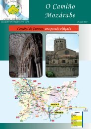
It is worth mentioning the boar culture inthis area of Frieiras, which came from thePlateau up to this point of the country. Thelast specimen was found in a celtic fortification(Castro) in Bembibre, on the way down tothe river Cambra, in Viana do Bolo.When the Romans got to Galicia, it wasdivi<strong>de</strong>d into three territorial districts and thisplace we are referring to -Serra do Cañizo–<strong>de</strong>marcates two of them: Asturicense district,on the north (Its capital was Astorga) andBracarense district (whose capital was Braga).The consequences of this <strong>de</strong>limitation canbe seen to<strong>da</strong>y: Astorga diocese still ends atthis point, thanks mainly to a documentwhich was forged in the 11 th century.Furthermore, until 1955 A Gudiña was divi<strong>de</strong>din two halves: San Pedro’s (Saint Peter’s)parish, on the north of the Vrea and headingto Santiago, belonged to Astorga; SanMartiño’s (Saint Martin’s) parish, o the south,belonged to Ourense’s bishopric. Despite thefact they belonged to different districts, theywere situated in the same province. Nowa<strong>da</strong>ysthe whole villa A Gudiña belongs to SanMaritpño’s parish and Ourense’s bishopric.The land of Frieiras was a very remarkablearea due to the mining industry, specially onthe slope from the ridge towards rivers Cambaand Bibei. Those close to river Camba, A Bouzaand Cal <strong>de</strong> Sinos, were gold mines, they tookthis precious metal using the same techniqueas in the Medulas -the most important goldmine in the Roman Empire. This techniquewas called PER RUINA MONTIUM. That iswhy there were paved roads in the mines.One of them crossed the area from south tonorth, and which were used as branches ofVia XVII. This road stared in Bracara Augusta(through Chaves). A milestone or kilometresign is still in O Tameirón. Other paved roadwas the previously mentioned Via XVII, with astation in Pinetos (Pinetum), to<strong>da</strong>y called Pentes.It is situated five kilometers from A Gudiña,heading south, over River Riberia whichcontinued up to Lubián and As Senabrega.Vía XVII joined vía XVI in Lubián. RodríguezColmenero points this Vía as the future Vreaof pilgrimage and royal way of Castile.As already mentioned in a previous article,in this zone, whose centre was A Mezquita,the Templar Knights -so called by King AlfonsoVII- settled in the 12 th century. Their aimwas to guard the new frontier created afterPortugal’s in<strong>de</strong>pen<strong>de</strong>nce in 1120. They shoul<strong>da</strong>lso <strong>de</strong>fend the route (which is still usedto<strong>da</strong>y) by protecting the travelers and pilgrimsin the difficult way of Requeixo, As Portelasand Sierra Seca. When the Templar knightswere suppressed, the nobility lords who weregranted with the Preben<strong>da</strong> (ecclesiasticalbenefit) assumed their position and they hadto go up against Portugal in several wars toconquer the country.We will continue some other time with A Gudiñaand A Serra Seca.8