Parque Nacional Volcan Poas - Costa Rica
Parque Nacional Volcan Poas - Costa Rica
Parque Nacional Volcan Poas - Costa Rica
- No tags were found...

Create successful ePaper yourself
Turn your PDF publications into a flip-book with our unique Google optimized e-Paper software.
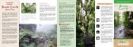
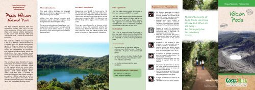
Central <strong>Volcan</strong>o RangeBiosphere ReserveConservation Area<strong>Poas</strong> <strong>Volcan</strong>National ParkThe Poás <strong>Volcan</strong>o National Park wascreated on January 25th, 1971. It is anactive composite volcano with a conicalshape and various caldera depressionsin the upper half. Between 1953 and1955 there were a series of strombolianeruptions.This protected wildlife area ranges from4,000 ft. to 8,860 ft. above sea level, atits highest point. Its 16,000 acres protectsspecies of flora and fauna, as well as animportant water resource. Its majesticforests are represented by rainforest,and lowland humid rainforest, which aredivided into four main habitats: cloudforest, rainforest, stunted or short forests,and areas with scarce vegetation aroundthe crater.The park has a great diversity of fauna,particularly its rich bird species wildlifewith 79 bird species recorded. Someof the species noted are: sooty robin,hummingbirds, quetzal, Rufous-collaredsparrow, and Yellow-thighed finch.There have also been a number ofmammals identified like shrews, weasels,porcupines, rabbits, squirrels, as well ascommon flora species like Poor man’sumbrella (gunera insingnsi), tree-shapedferns, and bromeliads, among others.Main attractions:The park offers facilities for disabledpeople, as well as tour guide services in theearly morning and at night.Visitors can also observe majestic andimpressive scenic views from various sitesalong the trails that the park offers.There are an abundance of epiphytes, treeshapeferns, and Poor man’s umbrella alongthe trails which offers visitors a uniqueexperience upon entering the Poás <strong>Volcan</strong>oNational Park.Poor Man’s Umbrella trailMeasuring some 2,000 ft. long and a 10-15 minute hike, this trail leads visitors to aspectacular lookout point of the Poás <strong>Volcan</strong>o’smain crater where you can observe the circulardepression measuring 4,330 f. in diameter and131 ft. deep with a lagoon rich in sulfur andacids.There are many fumaroles to observe, whichserves to show the consistent activity thisvolcano has. North of the main crater is theVon Frantzius cone, the oldest eruptive focalpoint at the top of the mammoth formation.Botos Lagoon trail:This trail takes visitors about 30 minutes tohike and measures 2,640 ft. in length.This trail takes visitors into the cloud forestwhere a great variety of plant species canbe observed and leads to Botos Lagoon.This lagoon is an old crater measuring 46ft. deep and 1,312 ft. in diameter providingcrystal-clear, cold water to the park.Escalonia trail:This 1,700 ft. long trail takes 20 minutes tohike and leads visitors into the heart of theforest where a variety of birds and flora canbe observed, as well as the majestic forestitself.Access Routes• In order to get to the park, take thenational route No.2 San José – Alajuela,San Isidro – Fraijanes – Poás <strong>Volcan</strong>o: (30miles).• Another option is to take the San Pedrode Poás, Fraijanes, Poás <strong>Volcan</strong>o route,if in Alajuela: (33 miles).• All routes are paved and in goodcondition.Horario de Atención / Open HoursDe 8:00 a.m. a 3:30 p.m.Todos los días. Everyday.Regulaciones / Regulations• Los <strong>Parque</strong>s <strong>Nacional</strong>es se crearoncon el fin de proteger nuestrosrecursos naturales, por lo tanto no espermitido extraer plantas, animales,rocas y otros materiales del lugar.• National parks were created toprotect our natural resources.Therefore, removing plants, animals,rocks, and other wildlife is prohibited.• Respete y cumpla la señalizaciónestablecida. Tiene un propósito muyimportante, para su seguridad y laconservación de los recursos.• Obey the signs posted. They play avery important role in your safety andin the conservation of the naturalresources.• Alimentar a los animales y dejarresiduos en el camino puede alterarsu dieta y conducta. ¡Evitémoslo!• Feeding animals and leaving behindtrash on the trails can adversely affecttheir diet and behavior. Don’t do it!• El ingreso de animales domésticospone en riesgo la vida silvestre. Suingreso no es permitido.• Bringing in domestic pets puts thewildlife in danger. Pets are notallowed.• El consumo de alimentos en el áreadel cráter y de la Laguna Botos noes permitido; utilice las áreas dealmuerzo establecidas.• Food consumption around the craterand Botos Lagoon is not permitted.Use the established meal areas.• El agua en <strong>Parque</strong> <strong>Nacional</strong> no espotable.• The water in the park is not potable.This land belongs to all<strong>Costa</strong> <strong>Rica</strong>ns, some havealready died, others arestill living …But the majority hasYet to be bornAnonymous<strong>Parque</strong> <strong>Nacional</strong> / National ParkLaguna Botos y Cráter PrincipalFotografía: Carlos Berrocal<strong>Volcan</strong><strong>Poas</strong>Sendero BotosFotografía: Fernando Bermúdez
Área de Conservación Cordillera Volcánica CentralReserva de la Biosfera<strong>Parque</strong> <strong>Nacional</strong><strong>Volcan</strong> <strong>Poas</strong>El <strong>Parque</strong> <strong>Nacional</strong> Volcán Poás fue creadoel 25 de enero de 1971. Se caracterizapor ser un estratovolcán activo deforma subcónica, con varias depresionescaldéricas en su parte superior. Entre elperíodo de 1953 - 1955 se produjo unaserie de erupciones estrombolianas.Esta Área Silvestre Protegida se encuentraa una altura entre los 1200 msnm a2708 msnm al punto más alto. En sus6506 hectáreas de extensión, el parqueprotege especies de flora, fauna y unimportante recurso hídrico. Con susmajestuosos bosques representados porel bosque pluvial montano y bosque muyhúmedo montano bajo caracterizadospor presentar cuatro hábitats principales,el bosque nuboso, el bosque húmedo; elbosque achaparrado o enano y áreas conescasa vegetación en los alrededores delcráter.El parque presenta una gran diversidad defauna, en la que se destaca la rica avifaunarepresentada por 79 especies de avesidentificadas, entre ellas: el escárchelo,colibrí, quetzal, comemaíz y saltón demuslos amarillos. Se han identificadouna variedad de mamíferos comomusarañas, comadrejas, puercoespines,conejos, ardillas y especies de flora máscomún, como es la sombrilla de pobre(Gunera insingnis) helechos arborescentes ybromelias entre otras.Principales atractivos:El <strong>Parque</strong> ofrece algunas facilidades parapersonas con discapacidad física, asícomo servicio de caminatas guiadas en lamadrugada y en la noche.Además, el visitante podrá observar unosadmirables e imponentes paisajes desdediferentes sitios, caracterizados por susmajestuosos atractivos y senderos queofrece el <strong>Parque</strong> <strong>Nacional</strong>.En sus senderos abundan las epifitas, loshelechos arborescentes y las sombrillasde pobre, que permiten al visitante teneruna experiencia única cuando ingresan al<strong>Parque</strong> <strong>Nacional</strong> Volcán Poás.Sendero Sombrilla de PobreCon una distancia de 600 m y con unaduración de 10 a 15 minutos, llevará alvisitante hasta el espectacular mirador delCráter Principal del Volcán Poás, dondepodrá observar una depresión caldérica de1320m de diámetro y una profundidad de320m, presenta en el fondo una laguna dede 400m de diámetro y 40m de profundidadde origen pluvial, rica en azufre y ácidos.Se pueden observar una gran cantidadde fumarolas que indican la actividadpermanente que posee este volcán. Al nortedel Cráter Principal se encuentra el ConoVon Frantzius, el más antiguo foco eruptivoen la cima del macizo.Laguna BotosFotografía: Adriana MurilloSendero Laguna Botos:Tiene una distancia de 800m, le tomará alvisitante unos 30 minutos en recorrerlo.Este sendero le ofrecerá al visitante internarsedentro del bosque nuboso y podrá observaruna gran variedad de plantas de diferentesespecies, hasta llegar a la Laguna Botos.Esta laguna es un antiguo cráter de 14m deprofundidad y 400m de diámetro con aguascristalinas y frías, dando abastecimiento deagua al parque.Sendero Escalonia:Con una distancia de 530m, se puede recorreren 20 minutos. Aquí, el visitante podráinternarse y caminar dentro del corazóndel bosque para observar una variedad deespecies de aves y flora, y disfrutar de lamajestuosidad del bosque.Rutas de acceso• Para llegar a este parque nacionalpuede utilizarse la ruta nacionalN°2 San José – Alajuela, San Isidro –Fraijanes – Volcán Poás: (50 km).• Otra opción en Alajuela es tomar porSan Pedro de Poás, Fraijanes, VolcánPoás: (55 km)• Todas las rutas se encuentran asfaltadasy en buenas condiciones.Transporte públicoPublic TransportationSan José - P.N. Volcán Poás. Calle 12 - 14,Avenida 2, San José (TUASA).Salida / Departure: 8:30 a.m.Regreso / Return: 2:00 p.mInstituto <strong>Costa</strong>rricense de TurismoDepartamento de Servicio al Turista<strong>Costa</strong> <strong>Rica</strong>n Tourism BoardTourist Service DepartmentOficinas centrales/Central Offices:Tel. 2291-5764 • 2299-5800 ext. 408Fax: 2291-5720 info@visitcostarica.comwww.visitecostarica.comCráter PrincipalFotografía: Marcela Alarcón<strong>Parque</strong> <strong>Nacional</strong> Volcán PoásCentro de Visitantes:Tel. (506) 2482 2424Oficina PN Volcán Poás:Telefax (506) 2482 1265pnvolcanpoas@accvc.orgwww.accvc.orgApartado 10104-1000San José, <strong>Costa</strong> <strong>Rica</strong><strong>Parque</strong> <strong>Nacional</strong> <strong>Volcan</strong> <strong>Poas</strong>