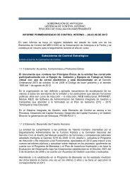
Estructura de la propiedad de la tierra rural en Antioquia, 2006-2011
Estructura de la propiedad de la tierra rural en Antioquia, 2006-2011
Estructura de la propiedad de la tierra rural en Antioquia, 2006-2011

You also want an ePaper? Increase the reach of your titles
YUMPU automatically turns print PDFs into web optimized ePapers that Google loves.
CG = 2(1/2 − T ) = 1 − 2T (1.2)<br />
n∑<br />
CG = 1 − (X i+1 − X i )(Y i + Y i+1 ) (1.3)<br />
i=1<br />
don<strong>de</strong> T repres<strong>en</strong>ta el área bajo <strong>la</strong> curva <strong>de</strong> Lor<strong>en</strong>z.<br />
En efecto, recurri<strong>en</strong>do al análisis <strong>de</strong> equival<strong>en</strong>cias geométricas, se <strong>de</strong>duc<strong>en</strong> primero<br />
(1.2) y luego (1.3). Sin embargo, y pese a que (1.3) es frecu<strong>en</strong>tem<strong>en</strong>te utilizada para<br />
trabajar con datos agrupados, exist<strong>en</strong> todavía otras dos expresiones que no requier<strong>en</strong><br />
ese cálculo y resultan ev<strong>en</strong>tualm<strong>en</strong>te útiles para <strong>la</strong> medición <strong>de</strong>l CG <strong>en</strong> estos casos<br />
don<strong>de</strong> los datos están agregados:<br />
CG = 1 −<br />
n∑<br />
x i (Y i + Y i+1 ) (1.4)<br />
i=1<br />
[ n∑<br />
]<br />
CG = 1 (X i Y i+1 − X i+1 Y i )<br />
10000<br />
i=1<br />
don<strong>de</strong> x i es <strong>la</strong> proporción (no acumu<strong>la</strong>da) <strong>de</strong> propietarios <strong>en</strong> el grupo i 9 .<br />
(1.5)<br />
Ambas aproximaciones, <strong>en</strong> teoría, converg<strong>en</strong> a resultados simi<strong>la</strong>res siempre y<br />
cuando <strong>la</strong> información <strong>de</strong> base sea <strong>la</strong> misma. No obstante, <strong>la</strong> poca s<strong>en</strong>sibilidad <strong>de</strong>l<br />
Gini ante transfer<strong>en</strong>cias <strong>en</strong>tre difer<strong>en</strong>tes segm<strong>en</strong>tos <strong>de</strong> <strong>la</strong> pob<strong>la</strong>ción, <strong>la</strong> rigi<strong>de</strong>z <strong>en</strong> su<br />
respuesta ante políticas <strong>de</strong> distribución y <strong>la</strong> poca flexibilidad <strong>en</strong> <strong>la</strong> <strong>de</strong>scomposición<br />
9 Los pasos para el cálculo <strong>de</strong> estos CG con datos agrupados, son los sigui<strong>en</strong>tes:<br />
1. Or<strong>de</strong>nar los propietarios <strong>en</strong> s<strong>en</strong>tido asc<strong>en</strong><strong>de</strong>nte <strong>de</strong> acuerdo con el área <strong>de</strong> los predios,<br />
2. Establecer el número <strong>de</strong> rangos,<br />
3. Calcu<strong>la</strong>r <strong>la</strong>s frecu<strong>en</strong>cias acumu<strong>la</strong>das <strong>de</strong>l número <strong>de</strong> hectáreas y <strong>de</strong>l número <strong>de</strong> propietarios,<br />
<strong>de</strong> acuerdo con los rangos establecidos, y finalm<strong>en</strong>te,<br />
4. Calcu<strong>la</strong>r el CG <strong>de</strong> acuerdo con alguna <strong>de</strong> <strong>la</strong>s medidas para datos agrupados, <strong>en</strong>tre <strong>la</strong>s que se<br />
<strong>en</strong>cu<strong>en</strong>tran (1.3), (1.4) y (1.5).<br />
22