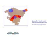
2. análisis de la situación actual de la red viaria - Garraioak
2. análisis de la situación actual de la red viaria - Garraioak
2. análisis de la situación actual de la red viaria - Garraioak

You also want an ePaper? Increase the reach of your titles
YUMPU automatically turns print PDFs into web optimized ePapers that Google loves.
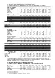
Respecto al conjunto <strong>de</strong> <strong>la</strong> Comunidad Autónoma, cabe indicar que los niveles <strong>de</strong> servicio se reparten casi<br />
equitativamente entre los niveles comprendidos entre el A y el C y el D y el F. Por otro <strong>la</strong>do, tan sólo un 3%<br />
<strong>de</strong> <strong>la</strong> longitud total <strong>de</strong> <strong>la</strong> Red muestra un nivel <strong>de</strong> servicio encuadrado en <strong>la</strong>s peores condiciones <strong>de</strong> confort<br />
para el usuario, aunque <strong>de</strong>staca que más <strong>de</strong> un tercio <strong>de</strong> <strong>la</strong> <strong>red</strong> tiene un nivel <strong>de</strong> servicio E, próximo a<br />
alcanzar <strong>la</strong>s condiciones <strong>de</strong> congestión.<br />
35,0%<br />
30,0%<br />
25,0%<br />
20,0%<br />
15,0%<br />
10,0%<br />
5,0%<br />
0,0%<br />
16%<br />
NIVEL DE SERVICIO EN LA CAPV<br />
(% KILÓMETROS DE RED OBJETO)<br />
19%<br />
16%<br />
12%<br />
33%<br />
A B C D E F<br />
Fuente: E<strong>la</strong>boración propia<br />
En resumen, <strong>la</strong>s carreteras que presentan un nivel <strong>de</strong> servicio F <strong>de</strong>ntro <strong>de</strong> <strong>la</strong> <strong>red</strong> <strong>de</strong>l País vasco, son:<br />
√ La carretera N-I, en el tramo <strong>de</strong> carretera que discurre entre los puntos kilométricos 448 y 454.<br />
√ La carretera N-637, en el cor<strong>red</strong>or Rontegi <strong>de</strong> Bilbao Metropolitano, con una longitud que supone el<br />
13% <strong>de</strong>l total.<br />
√ La carretera A-8 a su paso por el Bilbao Metropolitano así como a <strong>la</strong> entrada <strong>de</strong> Donostia-San<br />
Sebastián.<br />
3%<br />
Á<strong>la</strong>va<br />
Bizkaia<br />
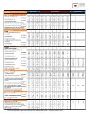
NIVEL DE SERVICIO, EN EL AÑO 2003, SEGÚN CARRETERA Y TERRITORIO HISTÓRICO<br />
(% KILÓMETROS DE RED OBJETO)<br />
Carretera A B C D E F<br />
AP-1 100 0 0 0 0 0<br />
AP-68 100 0 0 0 0 0<br />
N-I 6 52 37 5 0 0<br />
N-102 100 0 0 0 0 0<br />
N-104 0 0 0 15 85 0<br />
N-124 0 0 0 0 100 0<br />
N-240 10 44 11 0 34 0<br />
N-622 26 55 19 0 0 0<br />
N-624 100 0 0 0 0 0<br />
A-124 0 0 100 0 0 0<br />
A-132 0 100 0 0 0 0<br />
A-623 0 0 23 77 0 0<br />
A-624 0 13 87 0 0 0<br />
A-625 0 36 0 0 64 0<br />
A-627 0 0 0 0 100 0<br />
AP-68 70 30 0 0 0 0<br />
A-8 20 18 29 0 2 31<br />
N-240 0 0 0 41 59 0<br />
N-629 0 0 100 0 0 0<br />
N-633 54 0 46 0 0 0<br />
N-634 2 11 12 0 75 0<br />
N-636 0 0 0 0 100 0<br />
N-637 39 14 21 8 0 18<br />
N-639 0 0 0 0 100 0<br />
N-644 0 100 0 0 0 0<br />
BI-604 0 0 0 0 100 0<br />
BI-623 0 0 31 14 54 0<br />
BI-624 0 0 0 100 0 0<br />
BI-625 0 0 62 0 38 0<br />
237<br />
Revisión <strong>de</strong>l Segundo P<strong>la</strong>n General <strong>de</strong> Carreteras <strong>de</strong>l País Vasco