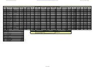
Red Municipal Bases Coordenadas UTM - Inicio
Red Municipal Bases Coordenadas UTM - Inicio
Red Municipal Bases Coordenadas UTM - Inicio

Create successful ePaper yourself
Turn your PDF publications into a flip-book with our unique Google optimized e-Paper software.
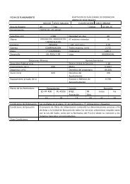
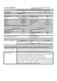
Nombre: V-946<br />
Numero: 946<br />
Hoja MTN 50: 1054<br />
Provincia: MÁLAGA<br />
Señal: Clavo<br />
Orienta con<br />
Situacion:<br />
Situado sobre borde de registro circular en el margen S de<br />
la carretera N-340, enfrentado a un vivero, y 400 m al O del<br />
acceso a Almayate Bajo. Orienta con V.947.<br />
Referencias:<br />
a= 1,70 perpendicular línea blanca<br />
b= 0,32 centro registro<br />
c=<br />
RESEÑA DE VÉRTICE<br />
Sistema Geodésico de Referencia ED 50<br />
COORDENADAS ED50<br />
GEOGRÁFICAS<br />
<strong>UTM</strong> (Huso 30)<br />
Longitud: -4º 07' 53.54'' O<br />
Latitud: 36º 43' 39.08'' N<br />
Convergencia (º): 3º 83' 05.00''<br />
Anamorfosis: 0.99972577<br />
X: 398955.528 m<br />
Y: 4065308.934 m<br />
H: 3.835 m