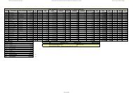
Red Municipal Bases Coordenadas UTM - Inicio
Red Municipal Bases Coordenadas UTM - Inicio
Red Municipal Bases Coordenadas UTM - Inicio

You also want an ePaper? Increase the reach of your titles
YUMPU automatically turns print PDFs into web optimized ePapers that Google loves.
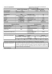
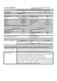
Nombre: V-932<br />
Numero: 932<br />
Hoja MTN 50: 1054<br />
Provincia: MÁLAGA<br />
Señal: Clavo<br />
Orienta con<br />
Situacion:<br />
Situado sobre una obra de fábrica para el paso de aguas<br />
frente al acceso a la urbanización Monte Azul, en la<br />
carretera N-340a, a la altura del P.K. 266,700. Orienta con<br />
V.914 y V.10.<br />
Referencias:<br />
a= 3,38 perpendicular linea blanca<br />
b= 4,00 esquina viga bionda<br />
c= 0,85 esquina viga bionda<br />
RESEÑA DE VÉRTICE<br />
Sistema Geodésico de Referencia ED 50<br />
COORDENADAS ED50<br />
GEOGRÁFICAS<br />
<strong>UTM</strong> (Huso 30)<br />
Longitud: -4º 08' 12.75'' O<br />
Latitud: 36º 43' 31.97'' N<br />
Convergencia (º): 0º 40' 47.91''<br />
Anamorfosis: 0.99972694<br />
X: 398476.414 m<br />
Y: 4065095.394 m<br />
H: 4.856 m