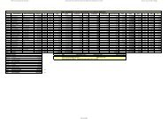
Red Municipal Bases Coordenadas UTM - Inicio
Red Municipal Bases Coordenadas UTM - Inicio
Red Municipal Bases Coordenadas UTM - Inicio

You also want an ePaper? Increase the reach of your titles
YUMPU automatically turns print PDFs into web optimized ePapers that Google loves.
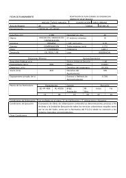
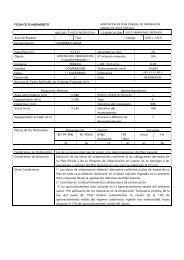
Nombre: V-931<br />
Numero: 931<br />
Hoja MTN 50: 1054<br />
Provincia: MÁLAGA<br />
Señal: Clavo<br />
Orienta con<br />
Situacion:<br />
A la altura del P.K. 269,500 de la N-340a sale un camino<br />
hacia la desmbocadura del río Benamargosa por su ribera<br />
oriental. A los 800m de iniciado éste el camino se bifurca.<br />
Al E de esta bifurcación en la esquina de un sifón, se<br />
encuentra la señal. Orienta<br />
Referencias:<br />
a= 0,09 perpendicular sifón<br />
b= 1,67 perpendicular sifón<br />
c= 1,67 perpendicular sifón<br />
RESEÑA DE VÉRTICE<br />
Sistema Geodésico de Referencia ED 50<br />
COORDENADAS ED50<br />
GEOGRÁFICAS<br />
<strong>UTM</strong> (Huso 30)<br />
Longitud: -4º 06' 10.03'' O<br />
Latitud: 36º 43' 49.35'' N<br />
Convergencia (º): 0º 39' 34.75''<br />
Anamorfosis: 0.99971943<br />
X: 401526.913 m<br />
Y: 4065595.593 m<br />
H: 1.783 m