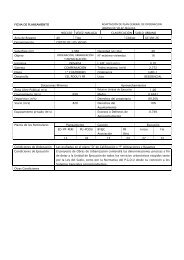
- Page 1 and 2:
Nombre: V-1 Numero: 1001 Hoja MTN 5
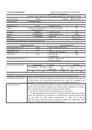
- Page 3 and 4:
Nombre: V-3 Numero: 1003 Hoja MTN 5
- Page 5 and 6:
Nombre: V-5 Numero: 1005 Hoja MTN 5
- Page 7 and 8:
Nombre: V-7 Numero: 1007 Hoja MTN 5
- Page 9 and 10:
Nombre: V-9 Numero: 1009 Hoja MTN 5
- Page 11 and 12:
Nombre: V-11 Numero: 1011 Hoja MTN
- Page 13 and 14:
Nombre: V-13 Numero: 1013 Hoja MTN
- Page 15 and 16:
Nombre: V-15 Numero: 1015 Hoja MTN
- Page 17 and 18:
Nombre: V-17 Numero: 1017 Hoja MTN
- Page 19 and 20:
Nombre: V-19 Numero: 1019 Hoja MTN
- Page 21 and 22:
Nombre: V-21 Numero: 1021 Hoja MTN
- Page 23 and 24:
Nombre: V-23 Numero: 1023 Hoja MTN
- Page 25 and 26:
Nombre: V-25 Numero: 1025 Hoja MTN
- Page 27 and 28:
Nombre: V-27 Numero: 1027 Hoja MTN
- Page 29 and 30:
Nombre: V-29 Numero: 1029 Hoja MTN
- Page 31 and 32:
Nombre: V-31 Numero: 1031 Hoja MTN
- Page 33 and 34:
Nombre: V-33 Numero: 1033 Hoja MTN
- Page 35 and 36:
Nombre: V-35 Numero: 1035 Hoja MTN
- Page 37 and 38:
Nombre: V-901 Numero: 901 Hoja MTN
- Page 39 and 40:
Nombre: V-903 Numero: 903 Hoja MTN
- Page 41 and 42:
Nombre: V-905 Numero: 905 Hoja MTN
- Page 43 and 44:
Nombre: V-907 Numero: 907 Hoja MTN
- Page 45 and 46:
Nombre: V-909 Numero: 909 Hoja MTN
- Page 47 and 48:
Nombre: V-911 Numero: 911 Hoja MTN
- Page 49 and 50:
Nombre: V-913 Numero: 913 Hoja MTN
- Page 51 and 52:
Nombre: V-915 Numero: 915 Hoja MTN
- Page 53 and 54:
Nombre: V-917 Numero: 917 Hoja MTN
- Page 55 and 56:
Nombre: V-919 Numero: 919 Hoja MTN
- Page 57 and 58:
Nombre: V-921 Numero: 921 Hoja MTN
- Page 59 and 60:
Nombre: V-923 Numero: 923 Hoja MTN
- Page 61 and 62:
Nombre: V-925 Numero: 925 Hoja MTN
- Page 63 and 64:
Nombre: V-927 Numero: 927 Hoja MTN
- Page 65 and 66:
Nombre: V-929 Numero: 929 Hoja MTN
- Page 67 and 68:
Nombre: V-931 Numero: 931 Hoja MTN
- Page 69 and 70:
Nombre: V-933 Numero: 933 Hoja MTN
- Page 71 and 72:
Nombre: V-935 Numero: 935 Hoja MTN
- Page 73 and 74:
Nombre: V-937 Numero: 937 Hoja MTN
- Page 75 and 76:
Nombre: V-939 Numero: 939 Hoja MTN
- Page 77 and 78:
Nombre: V-941 Numero: 941 Hoja MTN
- Page 79 and 80:
Nombre: V-943 Numero: 943 Hoja MTN
- Page 81 and 82:
Nombre: V-945 Numero: 945 Hoja MTN
- Page 83 and 84:
Nombre: V-947 Numero: 947 Hoja MTN
- Page 85 and 86:
Nombre: V-949 Numero: 949 Hoja MTN
- Page 87 and 88:
Nombre: V-952 Numero: 952 Hoja MTN
- Page 89 and 90:
Nombre: V-954 Numero: 954 Hoja MTN
- Page 91 and 92:
Nombre: V-956 Numero: 956 Hoja MTN
- Page 93 and 94:
Nombre: V-959 Numero: 959 Hoja MTN
- Page 95 and 96:
Nombre: V-961 Numero: 961 Hoja MTN
- Page 97 and 98:
Nombre: V-963 Numero: 963 Hoja MTN
- Page 99 and 100: Nombre: V-965 Numero: 965 Hoja MTN
- Page 101 and 102: Nombre: V-967 Numero: 967 Hoja MTN
- Page 103 and 104: Nombre: V-969 Numero: 969 Hoja MTN
- Page 105 and 106: Nombre: V-971 Numero: 971 Hoja MTN
- Page 107 and 108: Nombre: V-973 Numero: 973 Hoja MTN
- Page 109 and 110: Nombre: V-975 Numero: 975 Hoja MTN
- Page 111 and 112: Nombre: V-977 Numero: 977 Hoja MTN
- Page 113 and 114: Nombre: V-979 Numero: 979 Hoja MTN
- Page 115 and 116: Nombre: V-981 Numero: 981 Hoja MTN
- Page 117 and 118: Nombre: V-983 Numero: 983 Hoja MTN
- Page 119 and 120: Nombre: V-985 Numero: 985 Hoja MTN
- Page 121 and 122: Nombre: V-987 Numero: 987 Hoja MTN
- Page 123 and 124: Nombre: V-989 Numero: 989 Hoja MTN
- Page 125 and 126: Nombre: V-991 Numero: 991 Hoja MTN
- Page 127 and 128: Nombre: V-993 Numero: 993 Hoja MTN
- Page 129 and 130: Nombre: V-995 Numero: 995 Hoja MTN
- Page 131 and 132: Nombre: V-997 Numero: 997 Hoja MTN
- Page 133 and 134: Nombre: V-999 Numero: 999 Hoja MTN
- Page 135 and 136: Nombre: V-2001 Numero: 2001 Hoja MT
- Page 137 and 138: Nombre: V-2003 Numero: 2003 Hoja MT
- Page 139 and 140: Nombre: V-2005 Numero: 2005 Hoja MT
- Page 141 and 142: Nombre: V-2007 Numero: 2007 Hoja MT
- Page 143 and 144: Nombre: V-2009 Numero: 2009 Hoja MT
- Page 145 and 146: Nombre: V-2011 Numero: 2011 Hoja MT
- Page 147 and 148: Nombre: V-2013 Numero: 2013 Hoja MT
- Page 149: Nombre: V-2015 Numero: 2015 Hoja MT
- Page 153 and 154: Nombre: V-2019 Numero: 2019 Hoja MT
- Page 155 and 156: Nombre: V-2021 Numero: 2021 Hoja MT
- Page 157 and 158: Nombre: V-2023 Numero: 2023 Hoja MT
- Page 159 and 160: Nombre: V-2025 Numero: 2025 Hoja MT
- Page 161 and 162: Nombre: V-2027 Numero: 2027 Hoja MT
- Page 163 and 164: Nombre: V-2029 Numero: 2029 Hoja MT
- Page 165 and 166: Nombre: V-2032 Numero: 2032 Hoja MT
- Page 167 and 168: Nombre: V-2034 Numero: 2034 Hoja MT
- Page 169 and 170: Nombre: V-2036 Numero: 2036 Hoja MT
- Page 171 and 172: Nombre: V-2038 Numero: 2038 Hoja MT
- Page 173 and 174: Nombre: V-2040 Numero: 2040 Hoja MT
- Page 175 and 176: Nombre: V-2042 Numero: 2042 Hoja MT