Informe final* del Proyecto B002 Inventario de la ... - Conabio
Informe final* del Proyecto B002 Inventario de la ... - Conabio
Informe final* del Proyecto B002 Inventario de la ... - Conabio

Create successful ePaper yourself
Turn your PDF publications into a flip-book with our unique Google optimized e-Paper software.
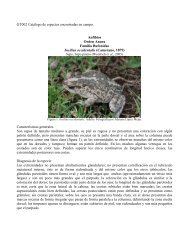
INFORME FINAL DE LAS SALIDAS A LA REGION DE LOS CHIMALAPAS,OAXACA.<br />
FECHA: FEBRERO - OCTUBRE DE 1995.<br />
LOCALIDADES: SAN ISIDRO LA GRINGA Y CHALCHIJAPA.<br />
GRUPO: HERPETOLOGIA.<br />
EDMUNDO PEREZ RAMOS<br />
LUIS CANSECO MARQUEZ.<br />
Con el presente informe damos un resumen final <strong>de</strong> <strong>la</strong>s<br />
activida<strong>de</strong>s llevadas a cabo <strong><strong>de</strong>l</strong> proyecto "<strong>Inventario</strong> <strong>de</strong> <strong>la</strong><br />
Biodiversidad <strong>de</strong> vertebrados terrestres <strong>de</strong> los Chima<strong>la</strong>pas,<br />
Oaxaca", en el cual <strong>de</strong>stacamos el hábitat, el intervalo<br />
altitudinal y regiones fisiográficas, don<strong>de</strong> fueron capturados los<br />
anfibios y reptiles <strong>de</strong> <strong>la</strong> región <strong>de</strong> los Chima<strong>la</strong>pas.<br />
Las localida<strong>de</strong>s visitadas fueron San Isidro La Gringa y<br />
Chalchijapa durante cuatro ocasiones cada una en el transcurso <strong>de</strong><br />
ocho meses, apartir <strong><strong>de</strong>l</strong> 17 <strong>de</strong> febrero al 28 <strong>de</strong> octubre <strong><strong>de</strong>l</strong> año en<br />
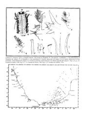
curso próximo pasado; allí se registraron un total <strong>de</strong> 73 especies<br />
y subespecies correspondientes a 22 <strong>de</strong> anfibios y 51 <strong>de</strong> reptiles<br />
(APENDICE 1). Ambas localida<strong>de</strong>s presentan zonas <strong>de</strong> vegetación<br />
primaria <strong>de</strong> Bosque Tropical Perennifolio y áreas perturbadas<br />
(acahuales, cultivos y potreros), a<strong>de</strong>más <strong>de</strong> vegetación <strong>de</strong> lugares<br />
inundables.<br />
En general, el intervalo altitudinal que se muestreó varió <strong>de</strong><br />
76-980 m en <strong>la</strong> primera localidad y <strong>de</strong> 210-975 m para <strong>la</strong> siguiente;<br />
presentándose áreas <strong>de</strong> montañas bajas y algunas partes p<strong>la</strong>nas. En<br />
<strong>la</strong>s dos localida<strong>de</strong>s existen cuencas <strong>de</strong> ríos permanentes <strong>de</strong><br />
corriente rápida, arroyos intermitentes o <strong>de</strong> fuertes crecidas y<br />
algunas zonas inundables.<br />
En el Apéndice 2 se muestran <strong>la</strong>s especies que se encuentran en<br />
alguna categoría <strong>de</strong> <strong>la</strong> norma oficial mexicana <strong>de</strong> SEDESOL y en los<br />
apéndices <strong><strong>de</strong>l</strong> SITES; se hace incapié que ninguna <strong>de</strong> los anfibios y