Full document / COSOC-W-86-002 - the National Sea Grant Library
Full document / COSOC-W-86-002 - the National Sea Grant Library Full document / COSOC-W-86-002 - the National Sea Grant Library
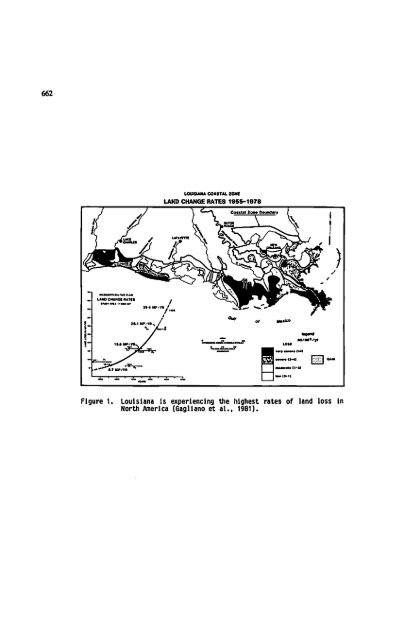
Estuarineand Coastal Management- Toob ofthe Trade. Proceedings of the TenthNationalConference of The Coastal Society. October 12-15.1986. New Orleans.LA. Copyrightby TheCoastalSociety 1987. Introduction RELATIVE SEA LEVEL RISE AND SUBSIDENCE MEASUREMENTS IN THE GULF OF MEXICO BASED ON NATIONAL OCEAN SURVEY TIDE GAUGE RECORDS SheaPenland, Karen Ramsey,andRandy A. McBride LouisianaGeological Survey University Station, Box G Baton Rouge. LA 70893 Coastal erosion in Louisiana Louisiana is experiencing the most severe land loss and barrier island erosion problem In the United States (Fig. 1). Land loss rates in the Mississippi River delta plain exceed 102 km2 per year (Gagliano et al. 1981). Louisiana experienced a decrease in total barrier island area of about 37 percent, from 92.4 km2 to 57.8 km2 between 1680 and 1979 (Penland and Boyd, 1981, 1982). Current predictions indicate the entire Plaquemines Parish delta plain will be converted into open water within 52 years, based on a land loss rate of 35.73 km2 per year and that the entire Terrebonne delta plain will be converted into open water within 102 years, based on a land loss rate of 27.7 km2 per year (Gagliano et al., 1981). Between 1887 and 1979, the Terrebonne Parish barrier islands decreased in area from 48.3 km2 to 18.3 km2. At a rate of 0.326 km2 these islands will be converted to submerged sand shoals in 56 years (Penland and Boyd, 1981; Fig. 2). Rapid relative sea level rise induced by delta plain subsidence and combined with a deficit of terrigenous wetland sedimentation are the primary factors driving the rapid deteri oration of the Louisiana coastal zone. Previous sea level rise studies Previous Investigations have documented that the analysis of tide gauge records is a valid technique for measuring relative sea level rise and 661
662 !- LAM) CHAMCI lUTtt — •» _^r IUmW'Vtl^y .«•"•*"•!»t&nm "* It 4 M< ».4 lOUSUJU COUTai ion LAND CHANGE RATES 1055-1078 | t«rf —— (Ml •MXiMI Figure 1. Louisiana Is experiencing the highest rates of land loss in North America (Gagliano et al., 1981).
- Page 207 and 208: Estuarineand Coastal Management- To
- Page 209 and 210: Application of the doctrine of Impl
- Page 211: oundaries of the dry sand area and
- Page 214 and 215: Estuarineand Coastal Management- To
- Page 216 and 217: compilation of existing data. Areas
- Page 218 and 219: To rank areas based on observed con
- Page 220 and 221: In spatial coverage of previous stu
- Page 222 and 223: Estuarineand Coastal Management- To
- Page 224 and 225: satellites to the reserve system, a
- Page 226 and 227: types of geomorphological features
- Page 228 and 229: Manao-gmgnr conaldpratH onn — The
- Page 230 and 231: productivity. The National Estuarin
- Page 232 and 233: Estuarine and Coastal Management To
- Page 234 and 235: equired to validate the sensitivity
- Page 236 and 237: goal, an uncertainty analysis was c
- Page 238 and 239: Precision of the sediment quality v
- Page 240 and 241: Estuarine andCoastal Management -To
- Page 242 and 243: Independent variable that is assume
- Page 244 and 245: Possible outcomes of the experiment
- Page 246 and 247: PREPARING FOR EMERGENCIES James McQ
- Page 248 and 249: 648 The evacuation of more than 500
- Page 250 and 251: 650 terminal; $220,000 for an oil s
- Page 252 and 253: 652 U.S. Highway 98 damage estimate
- Page 254 and 255: 654 Spangenbcrg, T. 1986. Personal
- Page 256 and 257: LOUISIANA'S BATTLEWITH THE SEA; ITS
- Page 260 and 261: Qco ISLES DERltt^ km & Figure 2. Hi
- Page 262 and 263: Objectives The first objective of t
- Page 264 and 265: STATION NUMBER STATION NAME TABLE 1
- Page 266 and 267: The St. Petersburg tide gauge stati
- Page 268 and 269: STATION NUMBER STATION NAME TABLE 2
- Page 270 and 271: elative sea level rise is 0.33 cm/y
- Page 272 and 273: References Byrne, P., Borengasser,
- Page 274 and 275: Estuarineand Coastal Management- To
- Page 276 and 277: these times that the increase in vu
- Page 278 and 279: econstruction projects. Conclusion
- Page 280 and 281: RESOLVING CONFLICTS/ASSESSING RISKS
- Page 282 and 283: 686 lightering is estimated at $69
- Page 284 and 285: BEACH EVOLUTION AFTER CAUSEWAY CONS
- Page 286 and 287: 690 and overriding the facility. Ic
- Page 288 and 289: Estuarine andCoastal Management - T
- Page 290 and 291: Inextricably wound up with religion
- Page 292 and 293: ethics is that advocated by Leopold
- Page 294 and 295: laboratory animals, lower animals a
- Page 296 and 297: Estuarine andCoastal Management-Too
- Page 298 and 299: Estuarine and Coastal Management To
- Page 300 and 301: 708 these projects. Our criteria fo
- Page 302 and 303: 710 S. alternlflora established on
- Page 304 and 305: 712 Additional compensation by ropl
- Page 306 and 307: 714 to the question of placement (l
662<br />
!-<br />
LAM) CHAMCI lUTtt<br />
— •» _^r<br />
IUmW'Vtl^y<br />
.«•"•*"•!»t&nm "*<br />
It 4 M<<br />
».4<br />
lOUSUJU COUTai ion<br />
LAND CHANGE RATES 1055-1078<br />
| t«rf —— (Ml<br />
•MXiMI<br />
Figure 1. Louisiana Is experiencing <strong>the</strong> highest rates of land loss in<br />
North America (Gagliano et al., 1981).


