

Ships on Maps - Index of
Ships on Maps - Index of
Ships on Maps - Index of

You also want an ePaper? Increase the reach of your titles
YUMPU automatically turns print PDFs into web optimized ePapers that Google loves.
<str<strong>on</strong>g>Ships</str<strong>on</strong>g> <strong>on</strong> <strong>Maps</strong><br />
Pictures <strong>of</strong> Power in Renaissance Europe<br />
R. Unger<br />
ISBN: 9780230282162<br />
DOI: 10.1057/9780230282162<br />
Palgrave Macmillan<br />
Please respect intellectual property rights<br />
This material is copyright and its use is restricted by our standard site license<br />
terms and c<strong>on</strong>diti<strong>on</strong>s (see palgravec<strong>on</strong>nect.com/pc/info/terms_c<strong>on</strong>diti<strong>on</strong>s.html).<br />
If you plan to copy, distribute or share in any format, including, for the avoidance<br />
<strong>of</strong> doubt, posting <strong>on</strong> websites, you need the express prior permissi<strong>on</strong> <strong>of</strong> Palgrave<br />
Macmillan. To request permissi<strong>on</strong> please c<strong>on</strong>tact rights@palgrave.com.
Early Modern History: Society and Culture<br />
General Editors: Rab Houst<strong>on</strong>, Pr<strong>of</strong>essor <strong>of</strong> Early Modern History, University <strong>of</strong> St<br />
Andrews, Scotland and Edward Muir, Pr<strong>of</strong>essor <strong>of</strong> History, Northwestern University,<br />
Illinois<br />
This series encompasses all aspects <strong>of</strong> early modern internati<strong>on</strong>al history from 1400 to<br />
c.1800. The editors seek fresh and adventurous m<strong>on</strong>ographs, especially those with a<br />
comparative and theoretical approach, from both new and established scholars.<br />
Titles include:<br />
Robert C. Davis<br />
CHRISTIAN SLAVES, MUSLIM MASTERS<br />
White Slavery in the Mediterranean, the Barbary Coast, and Italy, 1500–1800<br />
Rudolf Dekker<br />
CHILDHOOD, MEMORY AND AUTOBIOGRAPHY IN HOLLAND<br />
From the Golden Age to Romanticism<br />
Caroline Dodds Pennock<br />
BONDS OF BLOOD<br />
Gender, Lifecycle and Sacrifice in Aztec Culture<br />
Steve Hindle<br />
THE STATE AND SOCIAL CHANGE IN EARLY MODERN ENGLAND, 1550–1640<br />
Katharine Hodgkin<br />
MADNESS IN SEVENTEENTH CENTURY AUTOBIOGRAPHY<br />
Craig M. Kosl<strong>of</strong>sky<br />
THE REFORMATION OF THE DEAD<br />
Death and Ritual in Early Modern Germany, 1450–1700<br />
Beat Kümin<br />
DRINKING MATTERS<br />
Public Houses and Social Exchange in Early Modern Central Europe<br />
John Jeffries Martin<br />
MYTHS OF RENAISSANCE INDIVIDUALISM<br />
A. Lynn Martin<br />
ALCOHOL, SEX AND GENDER IN LATE MEDIEVAL AND EARLY MODERN EUROPE<br />
Samantha A. Meigs<br />
THE REFORMATIONS IN IRELAND<br />
Traditi<strong>on</strong> and C<strong>on</strong>fessi<strong>on</strong>alism, 1400–1690<br />
Craig Muldrew<br />
THE ECONOMY OF OBLIGATION<br />
The Culture <strong>of</strong> Credit and Social Relati<strong>on</strong>s in Early Modern England<br />
Niall Ó Ciosáin<br />
PRINT AND POPULAR CULTURE IN IRELAND, 1750–1850<br />
H. Eric R. Olsen<br />
THE CALABRIAN CHARLATAN, 1598–1603<br />
Messianic Nati<strong>on</strong>alism in Early Modern Europe<br />
Thomas Max Safley<br />
MATHEUS MILLER’S MEMOIR<br />
A Merchant’s Life in the Seventeenth Century<br />
10.1057/9780230282162 - <str<strong>on</strong>g>Ships</str<strong>on</strong>g> <strong>on</strong> <strong>Maps</strong>, Richard W. Unger
Clodagh Tait<br />
DEATH, BURIAL AND COMMEMORATION IN IRELAND, 1550–1650<br />
Richard W. Unger<br />
SHIPS ON MAPS<br />
Pictures <strong>of</strong> Power in Renaissance Europe<br />
Johan Verberckmoes<br />
LAUGHTER, JESTBOOKS AND SOCIETY IN THE SPANISH NETHERLANDS<br />
Claire Walker<br />
GENDER AND POLITICS IN EARLY MODERN EUROPE<br />
English C<strong>on</strong>vents in France and the Low Countries<br />
Johannes. C. Wolfart<br />
RELIGION, GOVERNMENT AND POLITICAL CULTURE IN EARLY MODERN GERMANY<br />
Lindau, 1520–1628<br />
Forthcoming titles:<br />
Caroline Dodds<br />
LIVING WITH SACRIFICE<br />
Early Modern History: Society and Culture<br />
Series Standing Order ISBN 978–0–333–71194–1 (Hardback) 978–0–333–80320–2 (Paperback)<br />
(outside North America <strong>on</strong>ly)<br />
You can receive future titles in this series as they are published by placing a standing order. Please<br />
c<strong>on</strong>tact your bookseller or, in case <strong>of</strong> difficulty, write to us at the address below with your name and<br />
address, the title <strong>of</strong> the series and the ISBN quoted above.<br />
Customer Services Department, Macmillan Distributi<strong>on</strong> Ltd, Houndmills, Basingstoke, Hampshire<br />
RG21 6XS, England<br />
10.1057/9780230282162 - <str<strong>on</strong>g>Ships</str<strong>on</strong>g> <strong>on</strong> <strong>Maps</strong>, Richard W. Unger
<str<strong>on</strong>g>Ships</str<strong>on</strong>g> <strong>on</strong> <strong>Maps</strong><br />
Pictures <strong>of</strong> Power in Renaissance Europe<br />
Richard W. Unger<br />
Pr<strong>of</strong>essor <strong>of</strong> History, University <strong>of</strong> British Columbia, Canada<br />
10.1057/9780230282162 - <str<strong>on</strong>g>Ships</str<strong>on</strong>g> <strong>on</strong> <strong>Maps</strong>, Richard W. Unger
© Richard W. Unger 2010<br />
All rights reserved. No reproducti<strong>on</strong>, copy or transmissi<strong>on</strong> <strong>of</strong> this publicati<strong>on</strong><br />
may be made without written permissi<strong>on</strong>.<br />
No porti<strong>on</strong> <strong>of</strong> this publicati<strong>on</strong> may be reproduced, copied or transmitted<br />
save with written permissi<strong>on</strong> or in accordance with the provisi<strong>on</strong>s <strong>of</strong> the<br />
Copyright, Designs and Patents Act 1988, or under the terms <strong>of</strong> any licence<br />
permitting limited copying issued by the Copyright Licensing Agency,<br />
Saffr<strong>on</strong> House, 6–10 Kirby Street, L<strong>on</strong>d<strong>on</strong> EC1N 8TS.<br />
Any pers<strong>on</strong> who does any unauthorized act in relati<strong>on</strong> to this publicati<strong>on</strong><br />
may be liable to criminal prosecuti<strong>on</strong> and civil claims for damages.<br />
The author has asserted his right to be identified as the author <strong>of</strong> this work<br />
in accordance with the Copyright, Designs and Patents Act 1988.<br />
First published 2010 by<br />
PALGRAVE MACMILLAN<br />
Palgrave Macmillan in the UK is an imprint <strong>of</strong> Macmillan Publishers Limited,<br />
registered in England, company number 785998, <strong>of</strong> Houndmills, Basingstoke,<br />
Hampshire RG21 6XS.<br />
Palgrave Macmillan in the US is a divisi<strong>on</strong> <strong>of</strong> St Martin’s Press LLC, 175 Fifth<br />
Avenue, New York, NY 10010.<br />
Palgrave Macmillan is the global academic imprint <strong>of</strong> the above companies<br />
and has companies and representatives throughout the world.<br />
Palgrave® and Macmillan® are registered trademarks in the United States,<br />
the United Kingdom, Europe and other countries<br />
ISBN 978-0-230-23164-1 hardback<br />
This book is printed <strong>on</strong> paper suitable for recycling and made from fully<br />
managed and sustained forest sources. Logging, pulping and manufacturing<br />
processes are expected to c<strong>on</strong>form to the envir<strong>on</strong>mental regulati<strong>on</strong>s <strong>of</strong> the<br />
country <strong>of</strong> origin.<br />
A catalogue record for this book is available from the British Library.<br />
Library <strong>of</strong> C<strong>on</strong>gress Cataloging-in-Publicati<strong>on</strong> Data<br />
Unger, Richard W.<br />
<str<strong>on</strong>g>Ships</str<strong>on</strong>g> <strong>on</strong> maps : pictures <strong>of</strong> power in Renaissance Europe / Richard W.<br />
Unger.<br />
p. cm.<br />
ISBN 978-0-230-23164-1 (hardback)<br />
1. Cartography–Europe–History–To 1500.<br />
2. Cartography–Europe–History–16th century. 3. Early<br />
maps–Europe–History. 4. <str<strong>on</strong>g>Ships</str<strong>on</strong>g>–<strong>Maps</strong>–Early works to 1800.<br />
5. Discoveries in geography. 6. Humanism. I. Title.<br />
GA231.U54 2010<br />
912.01′480940909024–dc22 2010011032<br />
10 9 8 7 6 5 4 3 2 1<br />
19 18 17 16 15 14 13 12 11 10<br />
Printed and bound in Great Britain by<br />
CPI Ant<strong>on</strong>y Rowe, Chippenham and Eastbourne<br />
10.1057/9780230282162 - <str<strong>on</strong>g>Ships</str<strong>on</strong>g> <strong>on</strong> <strong>Maps</strong>, Richard W. Unger
For my late l<strong>on</strong>g-time compani<strong>on</strong>s with roots in Newfoundland<br />
10.1057/9780230282162 - <str<strong>on</strong>g>Ships</str<strong>on</strong>g> <strong>on</strong> <strong>Maps</strong>, Richard W. Unger
This page intenti<strong>on</strong>ally left blank<br />
10.1057/9780230282162 - <str<strong>on</strong>g>Ships</str<strong>on</strong>g> <strong>on</strong> <strong>Maps</strong>, Richard W. Unger
C<strong>on</strong>tents<br />
List <strong>of</strong> Illustrati<strong>on</strong>s viii<br />
Preface xiii<br />
Acknowledgements xvii<br />
Abbreviati<strong>on</strong>s xviii<br />
Glossary <strong>of</strong> Shipbuilding Terms xix<br />
Introducti<strong>on</strong>: <strong>Maps</strong> and Mapping 1<br />
Chapter 1 Making <strong>Maps</strong> without <str<strong>on</strong>g>Ships</str<strong>on</strong>g>, with <str<strong>on</strong>g>Ships</str<strong>on</strong>g> 11<br />
Chapter 2 Mapping before the Renaissance 17<br />
Chapter 3 Portolans and the Late Medieval Transiti<strong>on</strong> 37<br />
Chapter 4 The Classical Revival, Printing and <strong>Maps</strong> 62<br />
Chapter 5 New Routes and Portuguese Map Makers 71<br />
Chapter 6 Iberian Influence in Southern Europe 95<br />
Chapter 7 Northern Europe and Southern Practices 125<br />
Chapter 8 <str<strong>on</strong>g>Ships</str<strong>on</strong>g>, Geography, and Humanism 152<br />
Epilogue 177<br />
Notes 180<br />
Bibliography 202<br />
<strong>Index</strong> 224<br />
vii<br />
10.1057/9780230282162 - <str<strong>on</strong>g>Ships</str<strong>on</strong>g> <strong>on</strong> <strong>Maps</strong>, Richard W. Unger
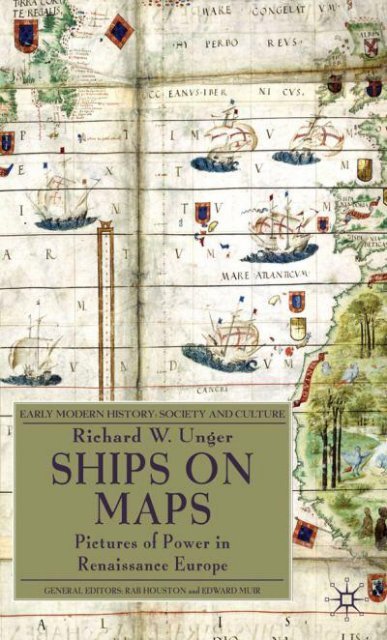
List <strong>of</strong> Illustrati<strong>on</strong>s<br />
Plates<br />
I Western Europe, North Africa and the Near East from the<br />
Catalan Atlas <strong>of</strong> 1375 by Abraham Cresques. Bibliothèque<br />
nati<strong>on</strong>ale de France, Espagnol 30, Planche III.<br />
II Portolan <strong>of</strong> the Mediterranean and eastern Atlantic by Mecia<br />
de Viladestes, 1413. Bibliothèque nati<strong>on</strong>ale de France, GE AA<br />
566 RES.<br />
III Jorge Reinel, 1510, South Indian Ocean with six ships <strong>of</strong>f the<br />
coasts <strong>of</strong> Africa. Herzog August Bibliothek, Wolfenbüttel:<br />
Cod, Guelf, 98 Aug. 20.<br />
IV The Indian Ocean with ships <strong>of</strong> varied types. From the Miller<br />
Atlas c. 1519 by Lopo Homem and the Reinels, father and s<strong>on</strong>.<br />
Bibliothèque nati<strong>on</strong>ale de France, GE AA 640 RES, fol. 3.<br />
V Diogo Ribeiro, planisphere <strong>of</strong> 1529. An 1889 copy <strong>of</strong> the<br />
original in the Vatican Library. Courtesy <strong>of</strong> the Library <strong>of</strong> C<strong>on</strong>gress,<br />
G3200 1529.R5 1889 MLC.<br />
VI Piri Reis World Map, 1513.<br />
From the collecti<strong>on</strong> <strong>of</strong> the James Ford Bell Library, University<br />
<strong>of</strong> Minnesota, facsimile (Kurumu Yayinlarindan: No 1);<br />
Istanbul: Devlet Basimevi, 1935; Bell 1935mPi.<br />
VII The Vallard Atlas, Southern Africa and the southwest Indian<br />
Ocean, Dieppe, 1547. This item is reproduced by permissi<strong>on</strong> <strong>of</strong><br />
The Huntingt<strong>on</strong> Library, San Marino, California, USA, HM29 f. 5.<br />
VIII Map to describe lands that were part <strong>of</strong> a legal dispute<br />
between Rotterdam and Delft, 1512, origin unknown.<br />
Nati<strong>on</strong>aal Archief, The Hague, Aanwinsten collectie kaarten<br />
en tekeningen (nummer toegang 4. AANW), inventory<br />
number 686.<br />
Figures<br />
2.1 Leaf [177] verso, T-O map, from Isidore <strong>of</strong> Seville, Isidori, 22<br />
Iunioris, Hispalensis, Episcopi liber, Etimologiarum, ad Brauli<strong>on</strong>em,<br />
Cesaraugustanum, Episcopum, Scriptus, incipit, foeliciter [Augsburg:<br />
Günter Zainer, 19 November 1472]. Hought<strong>on</strong> Library, Inc 1532.<br />
viii<br />
10.1057/9780230282162 - <str<strong>on</strong>g>Ships</str<strong>on</strong>g> <strong>on</strong> <strong>Maps</strong>, Richard W. Unger
List <strong>of</strong> Illustrati<strong>on</strong>s ix<br />
2.2 The Macrobian model <strong>of</strong> z<strong>on</strong>es, 1485, from Macrobius, 23<br />
In Somnium Scipi<strong>on</strong>is Expositio, Brescia, 1472. The John Carter<br />
Brown Library at Brown University.<br />
2.3 World Map <strong>of</strong> Beatus <strong>of</strong> Liebana, from Commentarius in 26<br />
Apocalypsim, Saint-Sever, C. 1060, The Saint-Sever family <strong>of</strong><br />
the maps have small open boats joining the fish in the<br />
surrounding ocean. Bibliothèque nati<strong>on</strong>ale de France,<br />
Latin 8878, Folio 45bisv – folio 45ter.<br />
2.4 The Ebstorf Map, a giant mappamundi from the early 29<br />
thirteenth century, lost in Hanover during an air raid in the<br />
Sec<strong>on</strong>d World War. Digital Rec<strong>on</strong>structi<strong>on</strong> Thomas Zapf,<br />
courtesy <strong>of</strong> Harmut Kügler.<br />
2.5 Matthew Paris, map <strong>of</strong> Acre with a camel <strong>on</strong> land and ships 34<br />
<strong>of</strong>f the coast. © British Library Board. All Rights Reserved.<br />
Royal MS 14 C vii f 4v & f 5.<br />
3.1 The Carte Pisane, the oldest surviving portolan chart, from 42<br />
the late thirteenth century. Bibliothèque nati<strong>on</strong>ale de France,<br />
GE B 1118 RES.<br />
3.2 Pietro Vesc<strong>on</strong>te, Portolan <strong>of</strong> western Europe, Venice c. 1325. 47<br />
© British Library Board. All Rights Reserved. Add. MS. 27376<br />
ff. 180v–181.<br />
3.3 Abraham Cresques, Catalan Atlas, 1375. Map <strong>of</strong> the Coast <strong>of</strong> 50<br />
Asia with possibly a junk and a boat and pearl fishers in the<br />
Indian Ocean. Bibliothèque nati<strong>on</strong>ale de France, Espagnol 30,<br />
Planche V.<br />
3.4 Abraham Cresques, Catalan Atlas, 1375. The ship <strong>of</strong> the 51<br />
explorer Jacme Ferrer <strong>of</strong>f the coast <strong>of</strong> west Africa. Bibliothèque<br />
nati<strong>on</strong>ale de France, Espagnol 30, Planche III.<br />
3.5 Petrus Roselli, Portolan Chart <strong>of</strong> c. 1450. 53<br />
The Edward E. Ayer Collecti<strong>on</strong>, The Newberry Library,<br />
Chicago, MS Map 3.<br />
3.6 Erhard Reuwich, Map <strong>of</strong> the Holy Land, drawn to illustrate 59<br />
Bernhard Breydenbach’s Peregrinatio in Terram Sanctum in a<br />
versi<strong>on</strong> published at Ly<strong>on</strong>s in 1489. The ship is at the lower<br />
left. © British Library Board. All Rights Reserved. IB.41612.<br />
3.7 Left half <strong>of</strong> a Map <strong>of</strong> the Holy Land from the Rudimentum 60<br />
Novitiorum, Lübeck, 1475, with ships including a<br />
great galley <strong>of</strong>f shore. Hought<strong>on</strong> Library, Typ Inc 2610 F.<br />
4.1 Coloured Map <strong>of</strong> Germania from the first printed editi<strong>on</strong> <strong>of</strong> 68<br />
Ptolemy, with two ships in the North and Baltic Seas.<br />
Ptolemaevs, Cladvivs. Cosmographia. Bologna, 1477.<br />
Reprint Amsterdam: N. Israel, 1963.<br />
The John Carter Brown Library at Brown University.<br />
10.1057/9780230282162 - <str<strong>on</strong>g>Ships</str<strong>on</strong>g> <strong>on</strong> <strong>Maps</strong>, Richard W. Unger
x List <strong>of</strong> Illustrati<strong>on</strong>s<br />
5.1 The Cantino Map, produced in Lisb<strong>on</strong> in 1502. 80<br />
Biblioteca Estense Universitaria, Modena, C. G. A. 2.<br />
5.2 Jorge Reinel, planisphere, 1519. Detail including South 82<br />
Atlantic and Indian Oceans. Redrawing <strong>of</strong> the original, now<br />
lost, d<strong>on</strong>e by Otto Progel around 1843. The John Carter<br />
Brown Library at Brown University.<br />
5.3 Lopo Homem and the Reinels, father and s<strong>on</strong>, the Miller 85<br />
Atlas c. 1519. The eastern Atlantic with ships including a<br />
caravel <strong>of</strong>f the west coast <strong>of</strong> Africa. Bibliothèque nati<strong>on</strong>ale<br />
de France, GE AA 640 RES, fol. 6.<br />
5.4 D. Joao de Castro, Portas de Esterito with 14 vessels <strong>of</strong> which 89<br />
eight are galleys from a rutter <strong>of</strong> the Indian Ocean. From his<br />
Roteiro que fes dom Joao de Castro de Viajem que Fezeram os<br />
Portugueses Desda India atee Soez… (Portugal, c. 1541). From<br />
the collecti<strong>on</strong> <strong>of</strong> the James Ford Bell Library, University <strong>of</strong><br />
Minnesota, Bell 1541 f Ca.<br />
5.5 Joao Freire, Atlas, 1546. Three vessels including a small open 91<br />
<strong>on</strong>e <strong>of</strong>f the west coast <strong>of</strong> northern Europe. This item is<br />
reproduced by permissi<strong>on</strong> <strong>of</strong> The Huntingt<strong>on</strong> Library, San Marino,<br />
California, USA, HM 35 f. 1.<br />
6.1 Juan de la Cosa, Map <strong>of</strong> the Atlantic with islands in the 97<br />
Caribbean, 1500, Museo Naval, Madrid.<br />
6.2 Pedro de Medina, Map <strong>of</strong> the Atlantic from his Arte de 102<br />
Nauegar…, 1545. The John Carter Brown Library at Brown<br />
University.<br />
6.3 Robert Thorne, map <strong>of</strong> 1527 d<strong>on</strong>e in Seville for the English 104<br />
ambassador. The John Carter Brown Library at Brown<br />
University.<br />
6.4 Battista Agnese, World Map showing route <strong>of</strong> Magellan, 107<br />
1543–5. The map was <strong>on</strong>ce owned by Emperor Charles V.<br />
The John Carter Brown Library at Brown University.<br />
6.5 Francanzano da M<strong>on</strong>talboddo, the first printed map <strong>of</strong> Africa, 108<br />
Milan, 1508. The John Carter Brown Library at Brown<br />
University.<br />
6.6 Giacomo Gastaldi, world map in the 1560 versi<strong>on</strong> by Paolo 109<br />
Forlani, Venice. © British Library Board. All Rights Reserved.<br />
MAPS C. 7. e. 1 (2) (state 1).<br />
6.7 Olaus Magnus, porti<strong>on</strong> <strong>of</strong> the Carta Marina, published at Venice 113<br />
in 1539. The John Carter Brown Library at Brown University.<br />
6.8 Jean Rotz, world map from the Boke <strong>of</strong> Idrography, 1542. 120<br />
© British Library Board. All Rights Reserved. BL Royal<br />
MS. 20E. ix.<br />
10.1057/9780230282162 - <str<strong>on</strong>g>Ships</str<strong>on</strong>g> <strong>on</strong> <strong>Maps</strong>, Richard W. Unger
List <strong>of</strong> Illustrati<strong>on</strong>s xi<br />
6.9 Pierre Desceliers, World Map <strong>of</strong> 1550 with different 122<br />
orientati<strong>on</strong>s for northern and southern hemispheres.<br />
© British Library Board. All Rights Reserved. BL Add Ms. 24065.<br />
7.1 Mounts Bay <strong>of</strong>f the coast <strong>of</strong> Cornwall, from a series <strong>of</strong> 129<br />
coastal views d<strong>on</strong>e for King Henry VIII, around 1540.<br />
© British Library Board. All Rights Reserved. BL Cott<strong>on</strong><br />
MS Augustus I.1. f. 35.<br />
7.2 Martin Waldseemüller, World Map <strong>of</strong> 1507. Courtesy <strong>of</strong> the 134<br />
Library <strong>of</strong> C<strong>on</strong>gress, G3200 CT000725C.<br />
7.3 Martin Waldseemüller, world map from his Carta Marina 135<br />
Navigatoria Portugallen Navigati<strong>on</strong>es Atque Tocius Cogniti Orbis<br />
Terre Marisque…, 1516. Courtesy <strong>of</strong> the Library <strong>of</strong> C<strong>on</strong>gress,<br />
Kislak Collecti<strong>on</strong>.<br />
7.4 Sebastian Münster, map <strong>of</strong> the western hemisphere, from his 137<br />
Cosmographia: B[e]schreibu[n]g aller Lender…. Basel: Henrichum<br />
Petri, 1544. From the collecti<strong>on</strong> <strong>of</strong> the James Ford Bell Library,<br />
University <strong>of</strong> Minnesota, Bell 1544 f Mu.<br />
7.5 Johannes Stumpf, Die Landkarten des Johann Stumpf 1538–1547, 138<br />
Aargau, Plate VII <strong>of</strong> the maps <strong>of</strong> Switzerland. Herzog August<br />
Bibliothek, Wolfenbüttel: Xb 2° 70, Karte VII.<br />
7.6 Jacob Roele<strong>of</strong>s, known as Jacob van Deventer, map <strong>of</strong> Zeeland, 142<br />
from a 1558 Italian copy. Nati<strong>on</strong>aal Archief, The Hague,<br />
Collectie Jacob van Deventer (nummer toegang 4. DEF),<br />
inventory number 20.<br />
7.7 Cornelis Ant<strong>on</strong>isz, Caerte van Oostlant, Antwerp, c. 1560 based 145<br />
<strong>on</strong> the original versi<strong>on</strong> <strong>of</strong> 1543 now lost. Herzog August<br />
Bibliothek, Wolfenbüttel: K 1,1.<br />
7.8 The title page <strong>of</strong> The Mariner’s Mirror, the English translati<strong>on</strong> 148<br />
<strong>of</strong> Lucas Jansz. Waghenaer’s Spiegel der Zeevaert, published in<br />
L<strong>on</strong>d<strong>on</strong>, 1588. The John Carter Brown Library at Brown<br />
University.<br />
7.9 Lucas Jansz. Waghenaer, Thresoor der Zeevaert, Leiden, 1592, 149<br />
Map <strong>of</strong> the Shetland Island. Collecti<strong>on</strong> Nederlands<br />
Scheepvaartmuseum Amsterdam.<br />
7.10 Gillis Coignet, plate from an astrolabe d<strong>on</strong>e at Antwerp, 1560. 151<br />
Museum <strong>of</strong> the History <strong>of</strong> Science, Oxford University.<br />
http://www.mhs.ox.ac.uk/astrolabe/images/53211/53211_<br />
complete_fr<strong>on</strong>t.jpg.<br />
8.1 Abraham Cresques, Catalan Atlas, 1375. Marco Polo and the 158<br />
rest <strong>of</strong> the family crossing Central Asia with a ship sailing an<br />
inland sea. Bibliothèque nati<strong>on</strong>ale de France, Espagnol 30,<br />
Planche V.<br />
10.1057/9780230282162 - <str<strong>on</strong>g>Ships</str<strong>on</strong>g> <strong>on</strong> <strong>Maps</strong>, Richard W. Unger
xii List <strong>of</strong> Illustrati<strong>on</strong>s<br />
8.2 Chain <strong>of</strong> pumps in use in mining, an illustrati<strong>on</strong> for De Re 162<br />
Metallica by Dr. Georg Bauer, known as Agricola, from a<br />
Basle editi<strong>on</strong> <strong>of</strong> 1561. The John Carter Brown Library at<br />
Brown University.<br />
8.3 King Manuel I the Fortunate <strong>of</strong> Portugal mounted <strong>on</strong> a fish 170<br />
<strong>of</strong>f the Cape <strong>of</strong> Good Hope, detail from Martin Waldseemüller,<br />
world map from his Carta Marina Navigatoria Portugallen<br />
Navigati<strong>on</strong>es Atque Tocius Cogniti Orbis Terre Marisque…,<br />
1516. Courtesy <strong>of</strong> the Library <strong>of</strong> C<strong>on</strong>gress, Kislak Collecti<strong>on</strong>.<br />
8.4 Neptune, riding a large fish, from Jacopo de’ Barbari’s 171<br />
bird’s-eye view <strong>of</strong> the city <strong>of</strong> Venice, 1500. Courtesy Novacco<br />
Collecti<strong>on</strong>, The Newberry Library, Chicago, Vault drawer<br />
Novacco 8F 7 (Sheet 5).<br />
8.5 People <strong>of</strong> the New World as seen by the Christian King <strong>of</strong> 172<br />
Portugal, from a work by Amerigo Vespucci, Leipzig, 1505.<br />
Herzog August Bibliothek, Wolfenbüttel: QuH 26 (5).<br />
8.6 Philip II riding <strong>on</strong> a shell drawn by horses c<strong>on</strong>trolled by 173<br />
Neptune <strong>of</strong>f the coast <strong>of</strong> the Netherlands, from a 1557 map<br />
by Hier<strong>on</strong>ymus Cock. Courtesy Novacco Collecti<strong>on</strong>,<br />
The Newberry Library, Chicago, Novacco 4F 155.<br />
8.7 Diego Gutiérrez, compiler, Hier<strong>on</strong>ymous Cock, engraver, 174<br />
Americae Sive Quartae Orbis Partis Nova Et Exactissima Descriptio<br />
[Antwerp]: 1562, North Atlantic with m<strong>on</strong>arch riding a<br />
chariot over the sea. Courtesy <strong>of</strong> the Library <strong>of</strong> C<strong>on</strong>gress,<br />
G3290 CT000342.<br />
10.1057/9780230282162 - <str<strong>on</strong>g>Ships</str<strong>on</strong>g> <strong>on</strong> <strong>Maps</strong>, Richard W. Unger
Preface<br />
The goal here is a simple <strong>on</strong>e: to explain why ships appeared as decorati<strong>on</strong> <strong>on</strong><br />
European maps beginning in the Renaissance. The understanding <strong>of</strong> maps and,<br />
with it, the history <strong>of</strong> cartography have underg<strong>on</strong>e a transformati<strong>on</strong> in the last<br />
four decades. The distinguished historian David Buisseret has identified three<br />
significant ways in which the field has changed. First, the definiti<strong>on</strong> <strong>of</strong> what is<br />
a map has become more extensive and more precise. Sec<strong>on</strong>d, there is now an<br />
effort and even a requirement to put maps in their social and ec<strong>on</strong>omic framework.<br />
Third, work <strong>of</strong> both historians and anthropologists has shown that there<br />
is a mapping impulse which is universal am<strong>on</strong>g human societies. 1 The first and<br />
last have meant a new understanding <strong>of</strong> mapping and dem<strong>on</strong>strated that there<br />
are many aspects to the ways in which people c<strong>on</strong>ceive <strong>of</strong> and then give graphic<br />
representati<strong>on</strong> to what they know about the physical world.<br />
‘There is a paradox at the heart <strong>of</strong> modern cartography. The more it aims to<br />
furnish a precise and comprehensive representati<strong>on</strong> <strong>of</strong> reality, the less true to<br />
life this representati<strong>on</strong> appears.’ 2 <strong>Maps</strong> are still and silent and static. They represent<br />
a point in time rather than existing in the unfolding <strong>of</strong> human acti<strong>on</strong>s.<br />
They are not true to life since people experience the world not statically but<br />
through moti<strong>on</strong>. While modern human beings have been trained by the cartography<br />
that emerged from the Renaissance to think in terms <strong>of</strong> coordinates,<br />
to locate sites in a mental map, that is not the <strong>on</strong>ly way to deal with comprehending<br />
the physical envir<strong>on</strong>ment. It may well be that rather than using mapping<br />
in that post-Renaissance sense that people in the past typically found<br />
their way by remembering the history <strong>of</strong> a place, by knowing a story <strong>of</strong> how to<br />
get from <strong>on</strong>e place to the next. 3 Way-finding existed before maps and c<strong>on</strong>tinued<br />
and still c<strong>on</strong>tinues even with the electr<strong>on</strong>ic aids to creating maps in the<br />
twenty-first century. GPS which becomes ever more comm<strong>on</strong> is in a sense a<br />
restorati<strong>on</strong> <strong>of</strong> way-finding with routes understood and presented <strong>on</strong> an electr<strong>on</strong>ic<br />
grid but with a disembodied voice reporting landmarks and giving directi<strong>on</strong>s<br />
<strong>on</strong> how to get to a destinati<strong>on</strong>. Way-finding lay at the heart <strong>of</strong> new forms<br />
<strong>of</strong> cartography in the Renaissance as did classical scientific efforts at mapping<br />
which reached fifteenth century map makers through rediscovered sec<strong>on</strong>d century<br />
texts. The combinati<strong>on</strong> <strong>of</strong> forces at work <strong>on</strong> the artists and scientists <strong>of</strong> the<br />
period all had an effect <strong>on</strong> their products which took <strong>on</strong> many new features. It<br />
was a period <strong>of</strong> uncertainty which opened the door to c<strong>on</strong>stant discovery.<br />
In what follows here there is little novel in the discussi<strong>on</strong> <strong>of</strong> the evoluti<strong>on</strong> <strong>of</strong><br />
maps from the classical world to and through the first half <strong>of</strong> the sixteenth century.<br />
Much <strong>of</strong> that development has been tracked in the past and with care by<br />
xiii<br />
10.1057/9780230282162 - <str<strong>on</strong>g>Ships</str<strong>on</strong>g> <strong>on</strong> <strong>Maps</strong>, Richard W. Unger
xiv Preface<br />
excellent historians, always with an eye to gathering the most comprehensive<br />
informati<strong>on</strong> possible. The pattern <strong>of</strong> change created the framework for choices<br />
made about what went <strong>on</strong> maps and so that history is necessary to understanding<br />
any aspect <strong>of</strong> what medieval map makers did. Existing histories <strong>of</strong><br />
cartography tend to repeat the same informati<strong>on</strong>, especially since the c<strong>on</strong>centrati<strong>on</strong><br />
has invariably been <strong>on</strong> the maps. What is <strong>of</strong> interest to every<strong>on</strong>e<br />
from scholar to reader is the maps themselves. Books and articles c<strong>on</strong>centrate<br />
rightly <strong>on</strong> reproducti<strong>on</strong>s and <strong>on</strong> illustrati<strong>on</strong> and so descriptive text is <strong>of</strong>ten<br />
limited. What historians say is then restricted and, logically, covers the essentials<br />
which in turn means the text <strong>of</strong>ten covers the same ground as others have<br />
covered in the past. This essay does not escape that pattern.<br />
Putting maps in their social and ec<strong>on</strong>omic c<strong>on</strong>text was certainly a break with<br />
past practice when it was first emphatically urged some 40 years ago. That<br />
approach, as Buisseret said, is now comm<strong>on</strong>. What had been a dramatic departure<br />
is now an ordinary part <strong>of</strong> the task <strong>of</strong> any<strong>on</strong>e looking at the history <strong>of</strong> cartography.<br />
Many aspects <strong>of</strong> the other changes in work in the field have also<br />
become ordinary. The process <strong>of</strong> looking at ships <strong>on</strong> maps, the genesis <strong>of</strong> this<br />
book, has <strong>of</strong> necessity meant rehearsing the techniques <strong>of</strong> the past. The additi<strong>on</strong>s<br />
made to both the methods and results are small. While the canvas may<br />
be broad the questi<strong>on</strong>s asked are narrow.<br />
To come to any understanding <strong>of</strong> why ships appeared <strong>on</strong> maps in the Renaissance<br />
all the varied methods and approaches <strong>of</strong> the history <strong>of</strong> cartography,<br />
including those that have recently emerged, should be brought to bear <strong>on</strong> the<br />
issue. That is attempted in the following pages. In dealing with the late Middle<br />
Ages and the Renaissance the precisi<strong>on</strong> so treasured by natural and social<br />
scientists is extremely difficult to achieve. Simple matters such as determining<br />
the numbers <strong>of</strong> maps made, the numbers <strong>of</strong> copies, and the frequency <strong>of</strong> producti<strong>on</strong><br />
are bey<strong>on</strong>d knowing. The size <strong>of</strong> the sample or any sample cannot<br />
be stated with any more than vague accuracy. There are variants to every case.<br />
Excepti<strong>on</strong>s to almost any statement about the maps abound. At best what can<br />
be attempted is to identify, trace, and perhaps also isolate tendencies.<br />
The search for an answer to the central questi<strong>on</strong> about ships has been a l<strong>on</strong>g<br />
sojourn through new and strange sources and ways <strong>of</strong> dealing with them. The<br />
voyage over what were and remain largely uncharted waters has taken all too<br />
much time. One result is massive debts. Those debts to individuals for their<br />
help with research, with supplying materials for illustrati<strong>on</strong>s, and with advice<br />
as well as inspirati<strong>on</strong> are extensive. T<strong>on</strong>y Campbell and Gillian Hutchins<strong>on</strong><br />
showed me the way through collecti<strong>on</strong>s <strong>of</strong> manuscript and sec<strong>on</strong>dary sources<br />
in England. Willem Moyzer Bruyns and Kees Zandvliet in the Netherlands<br />
and Albrecht Sauer in Germany supplied me with valuable informati<strong>on</strong> about<br />
navigati<strong>on</strong>. Only limited c<strong>on</strong>tact with René Tebel prevented me from taking<br />
advantage <strong>of</strong> his extensive knowledge <strong>of</strong> the topic. Corradino Astengo in Italy<br />
10.1057/9780230282162 - <str<strong>on</strong>g>Ships</str<strong>on</strong>g> <strong>on</strong> <strong>Maps</strong>, Richard W. Unger
Preface xv<br />
was an excellent host and source <strong>of</strong> advice. Francisco C<strong>on</strong>tente Domingues<br />
in Portugal has l<strong>on</strong>g showed an interest in the process. Robin Ward in England<br />
proved tireless in efforts to explain fifteenth century sailing practices. Ray<br />
Clemens introduced me to new sources and Mark Vessey at the University <strong>of</strong><br />
British Columbia brought his extensive knowledge <strong>of</strong> Erasmus to bear <strong>on</strong> a<br />
central problem. James Muldo<strong>on</strong> proved a great help with matters can<strong>on</strong>ical.<br />
Norman Fiering was a c<strong>on</strong>sistent supporter <strong>of</strong> the project. Richard Talbert and<br />
Leanne Bablitz joined me in organizing a c<strong>on</strong>ference <strong>on</strong> classical and medieval<br />
cartography which proved valuable in placing my own work in a larger framework.<br />
Neil Safier helped with books and a map <strong>of</strong> Brazil and R<strong>on</strong>nie Lakowski<br />
with Thomas More. Rachel Poliquin assisted the research using her knowledge<br />
<strong>of</strong> the rhetoric <strong>of</strong> the late Renaissance and her technical skills. Carol Mathes<strong>on</strong><br />
in a graduate seminar raised pertinent questi<strong>on</strong>s based <strong>on</strong> her own work<br />
and supplemented the catalogue <strong>of</strong> relevant maps. David Buisseret piqued<br />
interest in the history <strong>of</strong> cartography some years ago in a lecture <strong>on</strong> a visit to<br />
the University <strong>of</strong> British Columbia and, as with so many other historians, he<br />
redirected thinking and research because <strong>of</strong> his own ability to make so much<br />
<strong>of</strong> maps and do so sensibly. Susan Danforth at the John Carter Brown Library<br />
c<strong>on</strong>tributed to the final result through her knowledge <strong>of</strong> the history <strong>of</strong> cartography,<br />
her bibliographical skills, her knowledge <strong>of</strong> illustrative material, her<br />
willingness to comment <strong>on</strong> various aspects <strong>of</strong> the project and her good humour.<br />
Anne Taylor not <strong>on</strong>ly helped with the ways <strong>of</strong> research in the history <strong>of</strong> cartography<br />
and with advice about sources but also was a source <strong>of</strong> support in the<br />
closing stages <strong>of</strong> producing the final work. The editors <strong>of</strong> the series, Rab Houst<strong>on</strong><br />
and Ed Muir, <strong>of</strong>fered encouragement and sage advice about necessary changes<br />
in the closing stages <strong>of</strong> the process. I am grateful to all <strong>of</strong> them in helping to<br />
bring this all-too-drawn-out exercise to a c<strong>on</strong>clusi<strong>on</strong>.<br />
Audiences at c<strong>on</strong>ferences <strong>of</strong> the Medieval Associati<strong>on</strong> <strong>of</strong> the Pacific and the<br />
Medieval Academy <strong>of</strong> America were patient and <strong>of</strong>fered suggesti<strong>on</strong>s and probing<br />
questi<strong>on</strong>s. The same was true <strong>of</strong> audiences at the John Carter Brown Library.<br />
The members <strong>of</strong> the Internati<strong>on</strong>al Commissi<strong>on</strong> for the History <strong>of</strong> Technology<br />
allowed me to air some ideas at an early stage <strong>of</strong> the work. Jaap Bruijn and<br />
Elizabeth Archibald am<strong>on</strong>g a number <strong>of</strong> friends patiently listened to my hopes<br />
and frustrati<strong>on</strong>s about the project. The staff at the Nati<strong>on</strong>al Humanities Center,<br />
the New York Public Library, the Yale University Library, the Harvard University<br />
Library, the Huntingt<strong>on</strong> Library in San Marino, California, USA, the<br />
James Ford Bell Library <strong>of</strong> the University <strong>of</strong> Minnesota, the Leiden University<br />
Library, the Biblioteca Medicea Laurenziana in Florence, Italy, the British Library<br />
in L<strong>on</strong>d<strong>on</strong>, The University <strong>of</strong> Cambridge Library, the library <strong>of</strong> the Nati<strong>on</strong>al<br />
Maritime Museum in Greenwich, England, the University <strong>of</strong> British Columbia<br />
Library, and <strong>of</strong> course the John Carter Brown Library all have been extremely<br />
helpful and <strong>of</strong>ten unfailing in their efforts to assist the work. Dealing with<br />
10.1057/9780230282162 - <str<strong>on</strong>g>Ships</str<strong>on</strong>g> <strong>on</strong> <strong>Maps</strong>, Richard W. Unger
xvi Preface<br />
maps and the users <strong>of</strong> maps requires special skills am<strong>on</strong>g librarians and it is<br />
certainly the case that this book could not have been produced without the<br />
assistance <strong>of</strong> those talented and patient people. I am indebted to them, most<br />
especially William St<strong>on</strong>eman and Mary Haegert at the Hought<strong>on</strong> Library, Harvard<br />
University, Diederick Wildeman at the Nederlands Scheepvaartmuseum<br />
Amsterdam and Auste Mickunaite at the British Library, as well as the staffs<br />
<strong>of</strong> the Bibliothèque nati<strong>on</strong>ale de France in Paris and the Newberry Library<br />
in Chicago for their assistance and prompt acti<strong>on</strong> in making available some<br />
illustrati<strong>on</strong>s included in the book.<br />
The Netherlands Institute <strong>of</strong> Advanced Study and the University <strong>of</strong> British<br />
Columbia, the latter <strong>on</strong>ly at the beginning, provided financial support. Completi<strong>on</strong><br />
relied heavily <strong>on</strong> a period as the Jeannette D. Black Memorial Fellow<br />
at the John Carter Brown Library in Providence, Rhode Island, USA. The last<br />
part <strong>of</strong> the enterprise which brought this all-too-much delayed book to fruiti<strong>on</strong><br />
owed much to the D<strong>on</strong>nelley Family Fellowship, endowed by Strachan D<strong>on</strong>nelley,<br />
held at the Nati<strong>on</strong>al Humanities Center in Research Triangle Park, North<br />
Carolina, USA where the staff provided what was necessary to eliminate the last<br />
hurdles. Friends and colleagues have for some time tolerated my talking about<br />
maps and ships. Their willingness to listen and their interest have sustained the<br />
endeavour. The result may not answer all the relevant questi<strong>on</strong>s. The effort in<br />
the end possibly adds little to what is known but may, with luck, supplement<br />
ideas and understanding about broader trends in European science, technology,<br />
and society in the years from 1350 to 1550.<br />
10.1057/9780230282162 - <str<strong>on</strong>g>Ships</str<strong>on</strong>g> <strong>on</strong> <strong>Maps</strong>, Richard W. Unger
Acknowledgements<br />
For assistance with acquiring the images and permissi<strong>on</strong> to use them in this<br />
volume I am grateful to the John Carter Brown Library (Figures 2.2, 5.2, 6.2,<br />
6.3, 6.4, 6.5, 6.7, 7.8, 8.2), the Hought<strong>on</strong> Library (Figures 2.1, 3.7), the Herr<br />
August Bibliothek (Plate III, Figures 7.5, 7.7, 8.5), the Newberry Library (Figures<br />
3.5, 8.4, 8.6), the Huntingt<strong>on</strong> Library (Plate VII, Figure 5.5), the James Ford<br />
Bell Library (Plate VI, Figures 5.4, 7.4), the Biblioteca Estense Universitaria<br />
(Figure 5.1), the Bibliothèque nati<strong>on</strong>al de France (Plates I, II, IV, Figures 2.3,<br />
3.1, 3.3, 3.4, 3.6, 5.3, 8.1), the British Library (Figure 2.5, 3.2, 6.6, 6.8, 6.9, 7.1),<br />
the Library <strong>of</strong> C<strong>on</strong>gress (Plate V, Figures 7.2, 7.3, 8.3, 8.7), the Nati<strong>on</strong>al Archive<br />
<strong>of</strong> the Netherlands (Plate VIII, Figure 7.6), the Museo Naval Madrid (Figure 6.1),<br />
The Netherlands Scheepvaart Museum Amsterdam (Figure 7.9), the Museum <strong>of</strong><br />
the History <strong>of</strong> Science <strong>of</strong> Oxford University (Figure 7.10), and Harmut Kügler<br />
(Figure 2.4).<br />
xvii<br />
10.1057/9780230282162 - <str<strong>on</strong>g>Ships</str<strong>on</strong>g> <strong>on</strong> <strong>Maps</strong>, Richard W. Unger
Abbreviati<strong>on</strong>s<br />
BL British Library, L<strong>on</strong>d<strong>on</strong>, England<br />
BnF Bibliothèque nati<strong>on</strong>ale de France<br />
NMM Nati<strong>on</strong>al Maritime Museum, Greenwich, England<br />
NAH Nati<strong>on</strong>aal Archief, The Hague, The Netherlands<br />
xviii<br />
10.1057/9780230282162 - <str<strong>on</strong>g>Ships</str<strong>on</strong>g> <strong>on</strong> <strong>Maps</strong>, Richard W. Unger
Glossary <strong>of</strong> Shipbuilding Terms<br />
Barcha A single-masted sailing ship descended from the Viking l<strong>on</strong>gship<br />
with a length-to-breadth ratio <strong>of</strong> more than 4:1 and with<br />
curved posts at bow and stern. It was used for trading and fishing<br />
al<strong>on</strong>g the coast <strong>of</strong> the Bay <strong>of</strong> Biscay in the high Middle Ages<br />
and was employed extensively in fourteenth and early fifteenth<br />
century Spanish and Portuguese voyages <strong>of</strong> explorati<strong>on</strong>.<br />
B<strong>on</strong>net A rectangular piece <strong>of</strong> canvas sewed <strong>on</strong> to the bottom <strong>of</strong> a<br />
square sail or <strong>on</strong> to the bottom <strong>of</strong> another b<strong>on</strong>net to increase<br />
the total area. The two pieces to be fit together were similarly<br />
marked so there was no c<strong>on</strong>fusi<strong>on</strong> when joining them.<br />
Stitching was such that in case <strong>of</strong> str<strong>on</strong>g winds sailors could<br />
easily and quickly take <strong>of</strong>f the b<strong>on</strong>nets.<br />
Bowsprit A yard extending forward from the bow serving as a base for<br />
stays which held the foremast in place. Often a yard was slung<br />
under the bowsprit and a sail fixed to it. A piece <strong>of</strong> canvas<br />
placed there proved very useful in c<strong>on</strong>trolling the course <strong>of</strong><br />
the ship.<br />
Boyer A type <strong>of</strong> small ship in use in the North Sea in the sixteenth<br />
and seventeenth centuries with high levels <strong>of</strong> carrying capacity<br />
for each crewman. The efficiency was made possible by a<br />
complex rig involving a large spritsail as well as square sails<br />
and forestaysails, all <strong>on</strong> <strong>on</strong>e mast, and a small lateen sail <strong>on</strong> a<br />
mizzenmast.<br />
Caravel A fishing boat with north African roots which was modified<br />
for use in the Atlantic and became popular for fifteenth century<br />
Portuguese voyages <strong>of</strong> explorati<strong>on</strong>. It was l<strong>on</strong>g relative to<br />
its width and had little or no upperworks. Beginning with <strong>on</strong>e<br />
or two lateen rigged masts by the sixteenth century bigger caravels<br />
came from Iberian shipyards with three masts, all with<br />
lateen sails, or with four masts, three with lateen sails and the<br />
foremast with a square sail.<br />
Carrack A large sailing ship developed in the fourteenth century<br />
originally with two masts, the main carrying a single square<br />
sail and the mizzen carrying a lateen sail. With a deep and<br />
capacious hull it was suited for voyages between northern and<br />
southern Europe. The versi<strong>on</strong> with full-rig was probably first<br />
xix<br />
10.1057/9780230282162 - <str<strong>on</strong>g>Ships</str<strong>on</strong>g> <strong>on</strong> <strong>Maps</strong>, Richard W. Unger
xx Glossary <strong>of</strong> Shipbuilding Terms<br />
built in Iberia around 1400. It was more efficient and reliable<br />
and served the same routes as well as new <strong>on</strong>es between Europe<br />
and the Indian Ocean, that into the seventeenth century.<br />
It had a deep hold, a length-to-breadth ratio around 3:1, and<br />
<strong>of</strong>ten high castles.<br />
Carvel built Form <strong>of</strong> c<strong>on</strong>structi<strong>on</strong> where hull planks are pinned to an<br />
internal frame, the strength coming from the frame and<br />
watertightness from abutting the planks and caulking the<br />
seams.<br />
Forecastle Raised structure at the bow <strong>of</strong> a ship, originally as a platform<br />
but by the fifteenth century a fully integrated part <strong>of</strong> the hull<br />
and <strong>of</strong> varying heights. It came over time to be a place for<br />
housing crew members.<br />
After- or Raised structure at the stern <strong>of</strong> a ship, originally as a platform<br />
summer-castle but by the fifteenth century a fully integrated part <strong>of</strong> the hull<br />
and <strong>of</strong> varying heights and lengths, sometime reaching the<br />
mainmast. The aftercastle <strong>of</strong>fered a vantage point for pilots<br />
and more comfortable accommodati<strong>on</strong> than the forecastle.<br />
Clinker built Form <strong>of</strong> c<strong>on</strong>structi<strong>on</strong> where hull planks overlap and are<br />
nailed <strong>on</strong>e to the other. Strength comes from the hull itself<br />
with internal ribs <strong>of</strong>fering some reinforcement.<br />
Cocha Name given to the cog when it entered the Mediterranean<br />
and also to the earliest two-masted carracks in southern<br />
Europe.<br />
Cog A flat-bottomed coastal vessel with Celtic roots which, with<br />
the additi<strong>on</strong> <strong>of</strong> a keel in the twelfth century, became a sea<br />
going ship and over time the principal bulk carrier <strong>of</strong> goods<br />
in northern Europe. It was tubby with a length-to-breadth<br />
ratio <strong>of</strong> 3:1 or less. It had a single mast with a single square<br />
sail, sharply angled posts at the bow and stern, and a deep<br />
hold which gave it c<strong>on</strong>siderable carrying capacity.<br />
Falua A single-masted or possibly two-masted lateen rigged boat<br />
with a low pr<strong>of</strong>ile, straight gunwales, a raised platform at the<br />
stern where a helmsman or helmsmen stood c<strong>on</strong>trolling the<br />
steering oars, <strong>on</strong>e <strong>on</strong> each side.<br />
Full-rigged Ship with at least three masts, two <strong>of</strong> which carry square sails<br />
and a mizzen toward the stern with a lateen sail, the combinati<strong>on</strong><br />
increasing flexibility in deploying canvas and making<br />
it possible for ships to be relatively large and still manoeuvrable<br />
even in c<strong>on</strong>trary winds.<br />
10.1057/9780230282162 - <str<strong>on</strong>g>Ships</str<strong>on</strong>g> <strong>on</strong> <strong>Maps</strong>, Richard W. Unger
Glossary <strong>of</strong> Shipbuilding Terms xxi<br />
Galleass A large sailing ship <strong>of</strong> the sixteenth century equipped with<br />
oars and with a length-to-breadth ratio <strong>of</strong> around 5:1. Wellarmed,<br />
it was more manoeuvrable than sailing ships and better<br />
armed than galleys though the type proved cumbersome,<br />
required a very large crew, and was not a good sailor <strong>on</strong> the<br />
open ocean.<br />
Galley An oared vessel with a low pr<strong>of</strong>ile and relatively high lengthto-beam<br />
ratio, usually 6:1 or higher. Propulsi<strong>on</strong> came from<br />
oars <strong>on</strong> either side <strong>of</strong> the hull and, alternately, from sails. The<br />
arrangement <strong>of</strong> oarsmen took <strong>on</strong> varied c<strong>on</strong>figurati<strong>on</strong>s over<br />
time with <strong>on</strong>e <strong>of</strong> more banks <strong>of</strong> oars and with <strong>on</strong>e or multiple<br />
rowers per oar. Used extensively in the Mediterranean<br />
from classical Greece to the nineteenth century, the low freeboard<br />
made the type vulnerable to the high seas <strong>of</strong> the open<br />
ocean.<br />
Gunwale The highest strake or plank <strong>on</strong> the hull.<br />
Hulk A river and coastal vessel with Celtic roots used in the estuaries<br />
<strong>of</strong> the Rhine and <strong>on</strong> the North Sea in the early Middle<br />
Ages. It carried a single sail <strong>on</strong> a single mast and had a lengthto-breadth<br />
ratio <strong>of</strong> around 3:1 or somewhat more. With the<br />
additi<strong>on</strong> <strong>of</strong> a keel and changes to the way the planking was<br />
brought together at the bow, that in the fourteenth century,<br />
the hulk became a deep sea sailor and very similar to the<br />
cog from which it borrowed many <strong>of</strong> those design features.<br />
Adopting full rig by the sixteenth century the term<br />
came to apply to large, slow moving bulk carrying sailing<br />
ships.<br />
Mast:<br />
b<strong>on</strong>aventure The pole set furthest to the stern <strong>on</strong> a four-masted vessel.<br />
mizzen<br />
fore The pole for carrying yards set forward <strong>of</strong> the main mast in a<br />
ship <strong>of</strong> three or more masts.<br />
main The principal and largest and tallest pole for carrying yards,<br />
usually stepped about half way between bow and stern and<br />
<strong>of</strong>ten composite <strong>on</strong> larger ships, that is made up <strong>of</strong> parts <strong>of</strong><br />
more than <strong>on</strong>e tree.<br />
mizzen The first pole set astern <strong>of</strong> the mainmast.<br />
Outlicker A spar fixed high in the stern and projecting outward to<br />
take lines running from a sail rigged <strong>on</strong> a mast set far astern,<br />
usually a b<strong>on</strong>aventure mizzenmast.<br />
10.1057/9780230282162 - <str<strong>on</strong>g>Ships</str<strong>on</strong>g> <strong>on</strong> <strong>Maps</strong>, Richard W. Unger
xxii Glossary <strong>of</strong> Shipbuilding Terms<br />
Rig:<br />
fore-and-aft Sail or sails which operate in the same plane as the forward<br />
and aft line <strong>of</strong> the ship.<br />
full A combinati<strong>on</strong> <strong>of</strong> square sails <strong>on</strong> the main- and foremasts and<br />
a fore-and-aft or triangular sail <strong>on</strong> the third or mizzenmast.<br />
First developed around 1400 the presence <strong>of</strong> different types <strong>of</strong><br />
sails gave captains much greater c<strong>on</strong>trol over the vessel without<br />
losing power to drive the ship. It also <strong>of</strong>fered potential for<br />
reducti<strong>on</strong> in crew size.<br />
una The combinati<strong>on</strong> <strong>on</strong> a single mast <strong>of</strong> a fore-and-aft sail,<br />
usually a sprit sail, and a forestaysail. Developed probably in<br />
the fourteenth century it was used <strong>on</strong> small boats and could<br />
be handled by two people and even <strong>on</strong>e pers<strong>on</strong> al<strong>on</strong>e.<br />
Rudder:<br />
side A flat piece <strong>of</strong> wood, fixed near the stern <strong>of</strong> the ship and c<strong>on</strong>trolled<br />
by a steersman using a tiller fixed to the upper, narrow<br />
end <strong>of</strong> the oar. The methods <strong>of</strong> attachment to the hull varied<br />
but such rudders in general proved highly effective especially<br />
<strong>on</strong> boats and ships with low freeboard.<br />
sternpost A flat piece <strong>of</strong> wood fixed <strong>on</strong> hinges to the stern post <strong>of</strong> a ship<br />
and c<strong>on</strong>trolled by a tiller which passed over the top <strong>of</strong> the post<br />
or by a lever fixed at right angles to that tiller. Developed for<br />
use <strong>on</strong> the cog it became the comm<strong>on</strong> method for steering <strong>on</strong><br />
larger vessels by the end <strong>of</strong> the Middle Ages.<br />
Sail:<br />
lateen A triangular piece <strong>of</strong> canvas hanging down from a l<strong>on</strong>g yard,<br />
first used in the classical Mediterranean and the comm<strong>on</strong><br />
source <strong>of</strong> propulsi<strong>on</strong> for vessels there in the high Middle Ages.<br />
It made possible sailing closer to the wind than with a square<br />
sail. The lateen sail had the disadvantage that changing it<br />
from <strong>on</strong>e side <strong>of</strong> the mast to the other required carrying the<br />
yard over the top and around to the other side <strong>of</strong> the mast, a<br />
complex, time and pers<strong>on</strong>nel c<strong>on</strong>suming as well as dangerous<br />
task.<br />
lug A trapezoidal piece <strong>of</strong> canvas stretched between yards with<br />
60–80% <strong>of</strong> the sail <strong>on</strong> <strong>on</strong>e side <strong>of</strong> the mast. It was the typical<br />
rig <strong>of</strong> junks and also appeared <strong>on</strong> vessels in various parts <strong>of</strong><br />
the Indian Ocean.<br />
sprit A square or nearly square piece <strong>of</strong> canvas set in the fore-andaft<br />
line <strong>of</strong> the ship and held up by a boom in the same plane<br />
10.1057/9780230282162 - <str<strong>on</strong>g>Ships</str<strong>on</strong>g> <strong>on</strong> <strong>Maps</strong>, Richard W. Unger
Glossary <strong>of</strong> Shipbuilding Terms xxiii<br />
at a 45° or similar angle to the mast. It could be adjusted<br />
easily and required <strong>on</strong>ly limited manpower to handle, at least<br />
in smaller variants.<br />
square A rectangular piece <strong>of</strong> canvas set at a right angle or nearly<br />
right angle to the fore-and-aft line <strong>of</strong> the ship, hung down from<br />
a yard and sometimes stretched between two yards.<br />
stay A piece <strong>of</strong> canvas hanging down from <strong>on</strong>e <strong>of</strong> the stays which<br />
were lines stretched from the deck to the masts in order to<br />
hold those poles in place.<br />
top A rectangular piece <strong>of</strong> canvas set <strong>on</strong> a yard or stretched between<br />
two yards above the mainsail <strong>on</strong> a mast. It added potential<br />
driving power and, being smaller than the mainsail below<br />
it, required less effort to handle, an advantage since it was<br />
high in the rigging and so hard to reach. Over time topsails<br />
grew in size as mainsails got smaller. By the eighteenth<br />
century topsails could be as large or larger than mainsails.<br />
10.1057/9780230282162 - <str<strong>on</strong>g>Ships</str<strong>on</strong>g> <strong>on</strong> <strong>Maps</strong>, Richard W. Unger
This page intenti<strong>on</strong>ally left blank<br />
10.1057/9780230282162 - <str<strong>on</strong>g>Ships</str<strong>on</strong>g> <strong>on</strong> <strong>Maps</strong>, Richard W. Unger
Introducti<strong>on</strong>: <strong>Maps</strong> and Mapping<br />
<str<strong>on</strong>g>Ships</str<strong>on</strong>g> virtually never appeared <strong>on</strong> maps before 1375. By 1550 they filled oceans,<br />
seas, estuaries, rivers, and lakes <strong>on</strong> all kinds <strong>of</strong> maps from the most extensive<br />
to the most particular. The explanati<strong>on</strong> for the dramatic transformati<strong>on</strong> is to<br />
be found in the general changes in map making, in the explosi<strong>on</strong> <strong>of</strong> geographical<br />
knowledge and in the thinking <strong>of</strong> Europeans about themselves and<br />
their place in the world as it evolved during the Renaissance. Trying to make<br />
sense <strong>of</strong> the disappearance <strong>of</strong> ships from maps in the eighteenth century leads<br />
to similar sources for a turnaround with roots in changes in fashi<strong>on</strong>, in technology,<br />
in ideas about Europe and in ideas about the physical world. To identify<br />
and appreciate the reas<strong>on</strong>s for the rise and decline <strong>of</strong> decorative vessels <strong>on</strong><br />
maps requires an understanding <strong>of</strong> the prevailing ideas, the problems <strong>of</strong> representati<strong>on</strong><br />
and the structures <strong>of</strong> work and rewards that set the parameters for<br />
the makers <strong>of</strong> the maps. The process also requires a l<strong>on</strong>g voyage through<br />
many different images from small, simple sketches representing the world<br />
around the maker <strong>of</strong> the map all the way to some <strong>of</strong> the most grand and beautiful<br />
products <strong>of</strong> Renaissance art. The explanati<strong>on</strong>s serve to indicate and to<br />
illustrate the revoluti<strong>on</strong> in cartography in the fifteenth and sixteenth centuries<br />
as well as changing percepti<strong>on</strong>s am<strong>on</strong>g thinkers, writers and politicians.<br />
They serve equally to show how the immediate practical demands <strong>of</strong> new<br />
knowledge and the needs <strong>of</strong> maps users shaped art and representati<strong>on</strong>.<br />
<strong>Maps</strong> always treat a complicated world as uncomplicated. They are external,<br />
physical representati<strong>on</strong>s <strong>of</strong> the geographical envir<strong>on</strong>ment. They are multifaceted.<br />
They are always a misrepresentati<strong>on</strong> <strong>of</strong> the physical world since it is<br />
impossible to recreate the reality <strong>of</strong> land. They are automatically portrayals,<br />
likenesses, simplified models <strong>of</strong> the envir<strong>on</strong>ment. The exact duplicati<strong>on</strong><br />
<strong>of</strong> any geographical setting is impossible so maps, like all other forms <strong>of</strong> communicati<strong>on</strong>,<br />
purposefully fragment and simplify reality. Every map is automatically<br />
and <strong>of</strong> necessity, ‘…a record <strong>of</strong> mistranslati<strong>on</strong>, hence a major<br />
c<strong>on</strong>fr<strong>on</strong>tati<strong>on</strong> with the limits <strong>of</strong> representati<strong>on</strong>.’ 1 ‘Art, said Picasso, is a lie<br />
1<br />
10.1057/9780230282162 - <str<strong>on</strong>g>Ships</str<strong>on</strong>g> <strong>on</strong> <strong>Maps</strong>, Richard W. Unger
2 <str<strong>on</strong>g>Ships</str<strong>on</strong>g> <strong>on</strong> <strong>Maps</strong><br />
which makes us realize the truth. So is a map….And like any work <strong>of</strong> art, it<br />
requires imaginative reading.’ 2 <strong>Maps</strong> are made by people with definite purposes<br />
in mind so examining any map from any period becomes an exercise in<br />
understanding the purpose <strong>of</strong> the maker. ‘The map is simultaneously an<br />
instrument <strong>of</strong> communicati<strong>on</strong>…and an instrument <strong>of</strong> persuasi<strong>on</strong>…’. 3 Twentyfirst<br />
century maps are made <strong>on</strong> scientific principles and enjoy many c<strong>on</strong>venti<strong>on</strong>s<br />
and standards well-known to both makers and users <strong>of</strong> cartographers’<br />
products so they still depend <strong>on</strong> traditi<strong>on</strong> in order to transmit informati<strong>on</strong>.<br />
Even under the most modern <strong>of</strong> circumstances maps are still tied to the cultural<br />
c<strong>on</strong>text in which they are produced and very much to the motives <strong>of</strong><br />
their creators. 4<br />
A Renaissance map was both a work <strong>of</strong> art and a scientific product. As late as<br />
the seventeenth century Dutch Republic a distincti<strong>on</strong> between art and science<br />
made little if any sense to map makers. In the Renaissance maps were a form<br />
<strong>of</strong> decorative art. 5 Map making and landscape painting were similar activities<br />
and <strong>of</strong>ten d<strong>on</strong>e by the same people. In the two there were similar problems <strong>of</strong><br />
selecting what to show <strong>of</strong> the earth and how to represent those things <strong>on</strong> a<br />
plane surface. There was no terminology to distinguish between making maps<br />
and painting. In fact cartography is not about explaining nature but, ‘…a<br />
means <strong>of</strong> describing graphically certain categories <strong>of</strong> knowledge.’ 6 So the similarity<br />
with painting should not be surprising. Artists <strong>of</strong> the highest stature<br />
including, for example, Le<strong>on</strong>ardo Da Vinci and Albrecht Dürer did not shy<br />
away from making maps. Cartography in the Renaissance was closely related<br />
to scientific illustrati<strong>on</strong>, and like efforts to represent machines and the internal<br />
features <strong>of</strong> the human body, map making went through a significant<br />
change in the period. 7 The c<strong>on</strong>necti<strong>on</strong> to scientific illustrati<strong>on</strong> by the mid<br />
sixteenth century helped to give maps a new and different sort <strong>of</strong> intellectual<br />
authority.<br />
<strong>Maps</strong> In the late Middle Ages and the Renaissance were always reflecti<strong>on</strong>s <strong>of</strong><br />
c<strong>on</strong>temporary thought about science, philosophy and theology. Whether the<br />
interest in incorporating in maps greater and more accurate detail was a<br />
product <strong>of</strong> a rise in neoPlat<strong>on</strong>ism or <strong>of</strong> the resurgent nominalism <strong>of</strong> the via<br />
moderna associated with the English Franciscan William <strong>of</strong> Occam, the fact<br />
remained that even before the great geographical discoveries changes were<br />
underway in cartography. 8 Those changes were <strong>on</strong>ly accelerated by the spread<br />
<strong>of</strong> Renaissance thought and aesthetics from Italy and by the l<strong>on</strong>g term ec<strong>on</strong>omic<br />
growth which started in the first half <strong>of</strong> the fifteenth century. The use <strong>of</strong><br />
maps increased for various reas<strong>on</strong>s, some demographic, some ec<strong>on</strong>omic, some<br />
political but whatever the source the process c<strong>on</strong>tinued through the sixteenth<br />
century. In 1400 few Europeans used maps but by 1600 they were essential in<br />
many pr<strong>of</strong>essi<strong>on</strong>s. Whereas maps were rare in 1500 they were familiar objects<br />
<strong>of</strong> everyday life by 1600. Their numbers grew exp<strong>on</strong>entially. 9 The reas<strong>on</strong>s for<br />
10.1057/9780230282162 - <str<strong>on</strong>g>Ships</str<strong>on</strong>g> <strong>on</strong> <strong>Maps</strong>, Richard W. Unger
Introducti<strong>on</strong>: <strong>Maps</strong> and Mapping 3<br />
the transformati<strong>on</strong> include the Renaissance interest in Antiquity and so in<br />
classical mapping; the growing interest in quantificati<strong>on</strong> and measurement;<br />
rising literacy so maps could be and were used, for example, in court cases to<br />
do with land ownership; after 1517 the Protestant Reformati<strong>on</strong> which gave an<br />
impetus to the mapping <strong>of</strong> Biblical events; the ability to reproduce c<strong>on</strong>sistent<br />
copies with the potential for widespread distributi<strong>on</strong> through print and the<br />
expanding role <strong>of</strong> the state which found, starting with Italian city-states<br />
in the fifteenth century, more uses for maps in military enterprises and<br />
for administrati<strong>on</strong>. 10 The voyages <strong>of</strong> discovery and the need to represent<br />
additi<strong>on</strong>s to geographical knowledge al<strong>on</strong>g with the need for states to assert<br />
their status relative to other states in the new found lands promoted the<br />
producti<strong>on</strong>, use, and preservati<strong>on</strong> <strong>of</strong> maps. 11 The new uses <strong>of</strong> maps meant<br />
changes in their character, in some cases in unexpected ways. It is the changes<br />
which were bey<strong>on</strong>d or different from the scientific aspects, bey<strong>on</strong>d the<br />
drive for accuracy and c<strong>on</strong>sistency, which have recently and correctly become<br />
principal topics for historians.<br />
The earliest writers who examined the history <strong>of</strong> maps may have realized<br />
that the exercise <strong>of</strong> making such images had many dimensi<strong>on</strong>s but they paid<br />
little or no attenti<strong>on</strong> to decorati<strong>on</strong>. <str<strong>on</strong>g>Ships</str<strong>on</strong>g> <strong>on</strong> maps did not interest them.<br />
Those writers had to create a new vocabulary. The word cartography, that is<br />
cartographia in Portuguese, was invented by the Viscount de Santarém<br />
(1791–1856), ‘…the creator <strong>of</strong> the systematic history <strong>of</strong> cartography.’ He said<br />
in a letter in 1839 that he was making up the word. It first appeared in print<br />
in 1840. 12 Another inventi<strong>on</strong>, the word géographe appeared for the first time<br />
much earlier, that in French in 1557. For map makers cartographe did not<br />
appear in French until 1877. Before that the word was géographe for some<strong>on</strong>e<br />
who made maps. English followed the same pattern with geography not<br />
appearing until 1542. The first English writer to commit cartography to print<br />
appears to have been the explorer Richard Burt<strong>on</strong>, that in an article in the<br />
Journal <strong>of</strong> the Geographical Society in 1859. He was following the newest and<br />
best scientific trends <strong>of</strong> his day. The Viscount de Santarém based his study <strong>of</strong><br />
the evoluti<strong>on</strong> <strong>of</strong> European cartography <strong>on</strong> the examinati<strong>on</strong> <strong>of</strong> some 180 maps<br />
found through searching 300 libraries. 13 His atlas published in Paris in three<br />
volumes, the first editi<strong>on</strong> <strong>of</strong> which came out in 1841, was made up <strong>of</strong> what<br />
he called cartographic m<strong>on</strong>uments. In each new volume he moved back<br />
further in time, reaching the sixth century, since he felt compelled to look<br />
for the origins <strong>of</strong> modern map making. 14<br />
The Viscount de Santarém and those who followed after him were heavily<br />
influenced by c<strong>on</strong>temporary visi<strong>on</strong>s <strong>of</strong> science. They saw themselves as scientists<br />
too and so, just like the cartographers they described, sought accuracy.<br />
Their measure <strong>of</strong> the quality and value <strong>of</strong> any map was how well it reflected<br />
physical reality, how well it c<strong>on</strong>formed to the maps <strong>of</strong> their own day and to<br />
10.1057/9780230282162 - <str<strong>on</strong>g>Ships</str<strong>on</strong>g> <strong>on</strong> <strong>Maps</strong>, Richard W. Unger
4 <str<strong>on</strong>g>Ships</str<strong>on</strong>g> <strong>on</strong> <strong>Maps</strong><br />
future maps which would <strong>on</strong>ly improve as the field <strong>of</strong> cartography c<strong>on</strong>tinued<br />
to march forward toward ever greater precisi<strong>on</strong>. For those historians the progress<br />
<strong>of</strong> geography was the successive correcti<strong>on</strong> which led maps to approach<br />
the truth more closely. Such an approach was not surprising for the mid<br />
nineteenth century but as late as the mid twentieth century the history <strong>of</strong><br />
cartography was still largely about the increase in accuracy. 15 In 1953 the distinguished<br />
English map scholar, G. R. Cr<strong>on</strong>e said, ‘The history <strong>of</strong> cartography<br />
is largely that <strong>of</strong> the increase in the accuracy with which…elements <strong>of</strong><br />
distance and directi<strong>on</strong> are determined…’. 16 Certainly it would be wr<strong>on</strong>g to<br />
c<strong>on</strong>demn such an approach as trivial or unimportant. It still enjoys a measure<br />
<strong>of</strong> acceptance and will presumably always remain a part <strong>of</strong> the study <strong>of</strong> maps.<br />
Questi<strong>on</strong>s <strong>of</strong> accuracy are not nor should they be ignored, that despite disparaging<br />
remarks about such exercises which <strong>of</strong>ten populate recent work <strong>on</strong><br />
the history <strong>of</strong> maps. 17 However ‘…historians <strong>of</strong> cartographic representati<strong>on</strong><br />
should not be engaged in a discussi<strong>on</strong> <strong>of</strong> progress; indeed, the very noti<strong>on</strong> <strong>of</strong><br />
progress hampers them in understanding the true course <strong>of</strong> events.’ 18 The goal<br />
<strong>of</strong> outlining the march <strong>of</strong> progress gave the history <strong>of</strong> cartography in the past<br />
a certain bias, <strong>of</strong>ten to the exclusi<strong>on</strong> <strong>of</strong> other c<strong>on</strong>siderati<strong>on</strong>s. The principal<br />
items <strong>of</strong> interest to historians <strong>of</strong> maps, logically, were questi<strong>on</strong>s <strong>of</strong> what lands<br />
were <strong>on</strong> the maps, how accurately they were depicted and how maps were<br />
made. Historians worried about the mathematics and geometry, the methods<br />
used to create the representati<strong>on</strong>s. Only sec<strong>on</strong>darily if at all did the artistic<br />
comp<strong>on</strong>ents or approaches receive any c<strong>on</strong>siderati<strong>on</strong>. The decorati<strong>on</strong>, no<br />
matter how extensive or original or sumptuous, got little if any attenti<strong>on</strong>.<br />
In the last years <strong>of</strong> the twentieth century the study <strong>of</strong> maps and their<br />
history took <strong>on</strong> new aspects. Inspired by developments in other forms <strong>of</strong> historical<br />
study, by c<strong>on</strong>cern over c<strong>on</strong>cepts <strong>of</strong> accuracy, and by the relati<strong>on</strong>ship <strong>of</strong><br />
political power to various types <strong>of</strong> human expressi<strong>on</strong>, those studying maps<br />
began to discuss a broader range <strong>of</strong> questi<strong>on</strong>s. Sociological approaches to<br />
science had a critical influence. Study was not just about form and c<strong>on</strong>tent <strong>of</strong><br />
maps but also about the rate and directi<strong>on</strong> <strong>of</strong> change and about what social<br />
and cultural changes lay behind developments in maps. John Brian Harley<br />
(1932–91) took the lead in criticising those who ignored the c<strong>on</strong>text <strong>of</strong> maps<br />
and principally the political discourse embedded in maps but he was so<strong>on</strong> not<br />
al<strong>on</strong>e. 19<br />
Harley was an impassi<strong>on</strong>ed champi<strong>on</strong> <strong>of</strong> transforming and extending the<br />
field. Ultimately his view was ‘…that an alternative epistemology, rooted in<br />
social theory rather than in scientific positivism, is more appropriate to the<br />
history <strong>of</strong> cartography’. 20 The recasting <strong>of</strong> the language <strong>of</strong> historians <strong>of</strong> cartography<br />
is a sign <strong>of</strong> his success. As early as 1968 he worried in print about<br />
uncovering the intenti<strong>on</strong> <strong>of</strong> the map maker. Harley knew that would be difficult<br />
since <strong>of</strong>ten goals were not singular and with pre modern cartography<br />
10.1057/9780230282162 - <str<strong>on</strong>g>Ships</str<strong>on</strong>g> <strong>on</strong> <strong>Maps</strong>, Richard W. Unger
Introducti<strong>on</strong>: <strong>Maps</strong> and Mapping 5<br />
difficulties <strong>of</strong> interpretati<strong>on</strong>, he noted, are multiplied by the freedom cartographers<br />
had to exercise their imaginati<strong>on</strong>s. Twenty years later Harley was<br />
calling for understanding any map as, ‘…a socially c<strong>on</strong>structed form <strong>of</strong><br />
knowledge.’ 21 He wanted his colleagues to escape the standard map criticism<br />
<strong>of</strong> accuracy-inaccuracy. He borrowed from the study <strong>of</strong> images, that is the<br />
ic<strong>on</strong>ology <strong>of</strong> art historians, and from the sociology <strong>of</strong> knowledge, and especially<br />
from the observati<strong>on</strong>s <strong>of</strong> Michel Foucault (1926–84) about the relati<strong>on</strong>ship<br />
<strong>of</strong> seekers after truth to power. <strong>Maps</strong> were to Harley about an elusive<br />
and subtle process <strong>of</strong> dominati<strong>on</strong> where subliminal geometries, silences, and<br />
representati<strong>on</strong>al hierarchies act as agents <strong>of</strong> the impositi<strong>on</strong> <strong>of</strong> authority or<br />
ideas about authority. He c<strong>on</strong>cluded that ‘…the symbolic treatment <strong>of</strong> power<br />
is a neglected aspect <strong>of</strong> cartographic history. In grasping its importance we<br />
move away from a history <strong>of</strong> maps as a record <strong>of</strong> the cartographer’s intenti<strong>on</strong><br />
and technical acts to <strong>on</strong>e which locates the cartographic image in a social<br />
world’. 22 For him people, and especially people in positi<strong>on</strong>s <strong>of</strong> power who<br />
tried and succeeded in gaining c<strong>on</strong>trol over knowledge, dictated what went <strong>on</strong><br />
maps. They also dictated the exclusi<strong>on</strong> <strong>of</strong> certain aspects <strong>of</strong> life and <strong>of</strong> landscape,<br />
imposing silences <strong>on</strong> representati<strong>on</strong>s <strong>of</strong> the earth. Measurement and<br />
classificati<strong>on</strong> did, he acknowledged, give some sense <strong>of</strong> objectivity but maps<br />
did not in the process lose their subjective aspect. By 1989 he was pleased<br />
with the expansi<strong>on</strong> in the scope <strong>of</strong> cartographic studies to include ideas<br />
from informati<strong>on</strong> theory, linguistics, semiotics, structuralism, phenomenology,<br />
developmental theory, hermeneutics, ic<strong>on</strong>ology, Marxism and ideology.<br />
But he did note that there was no escape from past practice. Harley’s influence<br />
<strong>on</strong> the history <strong>of</strong> cartography since the 1960s has been impressive, an influence<br />
enhanced especially through the massive multi-volume History <strong>of</strong> Cartography<br />
which up to his untimely death he co-edited with David Woodward. 23<br />
While not universal am<strong>on</strong>g those who look at maps there is now <strong>of</strong>ten as<br />
much or more c<strong>on</strong>cern with the mental map that lay behind the presentati<strong>on</strong><br />
than with the appearance <strong>of</strong> the map itself. The history <strong>of</strong> map making is<br />
made a sub category <strong>of</strong> the more general study <strong>of</strong> l<strong>on</strong>g term developments in<br />
spatial representati<strong>on</strong>. While there may be an apparent c<strong>on</strong>flict between old<br />
and new schools in the history <strong>of</strong> cartography, worthy <strong>of</strong> debate am<strong>on</strong>g those<br />
in the field at internati<strong>on</strong>al meetings, there were even before Harley’s calls<br />
for examining the purpose <strong>of</strong> the history <strong>of</strong> cartography signs <strong>of</strong> c<strong>on</strong>cern and<br />
some broader discussi<strong>on</strong> <strong>of</strong> what maps were about. The symbolic importance<br />
<strong>of</strong> certain illustrati<strong>on</strong>s like flags l<strong>on</strong>g bothered historians. Medievalists, who<br />
had to deal with maps that were obviously inaccurate, regularly addressed<br />
questi<strong>on</strong>s about the functi<strong>on</strong> <strong>of</strong> maps and the goals <strong>of</strong> map makers. A fascinati<strong>on</strong><br />
with measurement that was reflected in maps in the fifteenth and<br />
sixteenth centuries was a phenomen<strong>on</strong> noticed well before Harley pointed to<br />
it as part <strong>of</strong> a drive toward expansi<strong>on</strong> <strong>of</strong> their political authority by princes. 24<br />
10.1057/9780230282162 - <str<strong>on</strong>g>Ships</str<strong>on</strong>g> <strong>on</strong> <strong>Maps</strong>, Richard W. Unger
6 <str<strong>on</strong>g>Ships</str<strong>on</strong>g> <strong>on</strong> <strong>Maps</strong><br />
The goal <strong>of</strong> the history <strong>of</strong> cartography is now to see bey<strong>on</strong>d the obvious, to<br />
try to appreciate the whole functi<strong>on</strong> and purpose <strong>of</strong> graphic representati<strong>on</strong>s<br />
<strong>of</strong> the physical world. The history <strong>of</strong> maps is then not about progress or about<br />
an evoluti<strong>on</strong> in methods toward ever greater accuracy but rather a saga <strong>of</strong> ups<br />
and downs, <strong>of</strong> different directi<strong>on</strong>s taken, and <strong>of</strong> choices about what to include<br />
and what to exclude and about the reas<strong>on</strong>s at any time for the choices map<br />
makers made. In some cases the goal was to show routes, in others to express<br />
images, and in many the goals were mixed with numerous influences at work.<br />
That was especially true <strong>of</strong> representati<strong>on</strong>s <strong>of</strong> the discoveries made by European<br />
explorers. 25 Rather than look to the Renaissance for some sharp break<br />
between a medieval period when maps were decorative and a modern period<br />
where maps were scientific representati<strong>on</strong>s <strong>of</strong> reality, the need is to look at<br />
who made maps and for whom and why. To do that maps should be exposed<br />
to the same type <strong>of</strong> analysis l<strong>on</strong>g known for literary texts. Like them maps<br />
present problems <strong>of</strong> translati<strong>on</strong> with the language difficult to interpret for<br />
any<strong>on</strong>e not comfortable with it, and maps do have their own languages. Like<br />
literary works maps present problems <strong>of</strong> recepti<strong>on</strong>, <strong>of</strong> the varied reacti<strong>on</strong>s<br />
elicited by them in different places and at different times. <strong>Maps</strong>, however, are<br />
<strong>of</strong>ten more complex and richer and with added dimensi<strong>on</strong>s so the task <strong>of</strong><br />
analysing them can be daunting.<br />
Above all recent work <strong>on</strong> maps has forced a fuller and more careful c<strong>on</strong>siderati<strong>on</strong><br />
<strong>of</strong> the political elements in them. That c<strong>on</strong>centrati<strong>on</strong> does raise the<br />
possibility <strong>of</strong> overemphasis <strong>on</strong> just <strong>on</strong>e <strong>of</strong> the many features <strong>of</strong> maps and the<br />
possibility <strong>of</strong> ignoring some <strong>of</strong> the other ideas embedded in the representati<strong>on</strong>s<br />
<strong>of</strong> the world. The c<strong>on</strong>centrati<strong>on</strong> <strong>on</strong> maps as instruments <strong>of</strong> power and<br />
dominati<strong>on</strong> and legitimati<strong>on</strong>s <strong>of</strong> violence, as part <strong>of</strong> an imperial project, is<br />
most prevalent am<strong>on</strong>g but not exclusive to those examining the history <strong>of</strong> the<br />
New World and especially the USA where the tortured history <strong>of</strong> relati<strong>on</strong>s<br />
with the peoples that Europeans encountered hangs over any discussi<strong>on</strong> <strong>of</strong><br />
space. As with envir<strong>on</strong>mental historians, caught up in the myth <strong>of</strong> a pristine<br />
America before that name was imposed <strong>on</strong> the c<strong>on</strong>tinents, so too historians <strong>of</strong><br />
cartography both lose sight <strong>of</strong> the world before 1492 and lose sight <strong>of</strong> a world<br />
bey<strong>on</strong>d the borders with which they are familiar. In additi<strong>on</strong> in c<strong>on</strong>centrating<br />
<strong>on</strong> map making as appropriati<strong>on</strong> historians can enjoy the satisfacti<strong>on</strong><br />
<strong>of</strong> uncovering a c<strong>on</strong>spiracy, <strong>of</strong> exposing a plot to obscure the exploitati<strong>on</strong> <strong>of</strong><br />
land and people. While it may be true that, ‘There is nothing in the map that<br />
fails to signify.’ the statement is trivial or at least inflated if what is signified is<br />
something mundane rather than a grand political process. 26 States and their<br />
interests were not the <strong>on</strong>ly forces at work in shaping mapping. The search for<br />
an overarching theory <strong>of</strong> the development <strong>of</strong> human society may obscure the<br />
more immediate and purely practical needs <strong>of</strong> the buyers and makers <strong>of</strong> maps.<br />
There were other groups and individuals whose interests diverged from those<br />
10.1057/9780230282162 - <str<strong>on</strong>g>Ships</str<strong>on</strong>g> <strong>on</strong> <strong>Maps</strong>, Richard W. Unger
Introducti<strong>on</strong>: <strong>Maps</strong> and Mapping 7<br />
<strong>of</strong> growing centralizing governments who could and did influence what<br />
was put <strong>on</strong> and what was left <strong>of</strong>f maps. 27<br />
While it would be difficult to dispute that, ‘The map is a silent arbiter <strong>of</strong><br />
power’ 28 it is doubtful that the Renaissance map makers saw using maps<br />
for political purposes as original with them. While it may be difficult to dispute<br />
that, ‘As much as guns and warships, maps have been the weap<strong>on</strong>s <strong>of</strong><br />
imperialism’, 29 it is doubtful that such was their principal purpose or even an<br />
important <strong>on</strong>e for the people who made them or had them made. While governments<br />
have been instrumental in the promoti<strong>on</strong> and use <strong>of</strong> maps to say<br />
that, ‘The history <strong>of</strong> the map is inextricably linked to the rise <strong>of</strong> the nati<strong>on</strong><br />
state in the modern world’ 30 is to obscure many other influences <strong>on</strong> map<br />
making, especially in the later years <strong>of</strong> the Middle Ages and the Renaissance<br />
when the nati<strong>on</strong> state did not yet exist nor had even been imagined. Medieval<br />
maps do show the size <strong>of</strong> towns or castles in proporti<strong>on</strong> to perceived importance<br />
rather than actual size and use various symbols such as flags to indicate<br />
political identity, 31 so there were c<strong>on</strong>necti<strong>on</strong>s to power in what cartographers<br />
put <strong>on</strong> maps before the Renaissance. That fact <strong>on</strong>ly increases the danger <strong>of</strong><br />
finding the authority <strong>of</strong> the state seeping into every symbol <strong>on</strong> every map<br />
all the time. Seeing the map as, ‘…a social tool, a tool <strong>of</strong> power that helps to<br />
impose a visi<strong>on</strong> <strong>of</strong> the world up<strong>on</strong> a society at a given time and in a given<br />
place, embedding values, ideology, and subliminal meanings into what seems<br />
to be an objective statement <strong>of</strong> the real world’, 32 may describe the effect <strong>of</strong><br />
those representati<strong>on</strong>s but at the same time may say little about the intenti<strong>on</strong>s<br />
or the thinking <strong>of</strong> the people who created the surviving examples <strong>of</strong><br />
Renaissance cartography.<br />
If the emphasis in the history <strong>of</strong> cartography has shifted in recent years<br />
away from the outline <strong>of</strong> the physical world to the many other features <strong>of</strong><br />
maps then the ships that appeared <strong>on</strong> them in the fifteenth and sixteenth<br />
centuries become a proper and even important matter for c<strong>on</strong>siderati<strong>on</strong>. The<br />
evoluti<strong>on</strong> <strong>of</strong> graphic depicti<strong>on</strong>, <strong>on</strong>e <strong>of</strong> the most obvious and important features<br />
<strong>of</strong> Renaissance cartography, included not just shorelines or mountains.<br />
The fuller and more frequent and more accurate representati<strong>on</strong> <strong>of</strong> many features<br />
<strong>of</strong> the world were all a part <strong>of</strong> the development <strong>of</strong> map making. <str<strong>on</strong>g>Ships</str<strong>on</strong>g><br />
were am<strong>on</strong>g those features. Map makers, directed by their patr<strong>on</strong>s or potential<br />
customers or following their own independent noti<strong>on</strong>s, chose to adopt ships<br />
as a part <strong>of</strong> maps. Map makers did not, at least in the late Middle Ages, blindly<br />
follow some standard or c<strong>on</strong>venti<strong>on</strong>. It was a matter <strong>of</strong> choice and their choice<br />
to put ships <strong>on</strong> the waters <strong>of</strong> their maps indicates that there was a purpose in<br />
including vessels. ‘…the map is not just <strong>on</strong>e image am<strong>on</strong>g others: the writing<br />
and language <strong>on</strong> its surface are <strong>of</strong> prep<strong>on</strong>derant importance. The map’s modes<br />
<strong>of</strong> inscripti<strong>on</strong> and graphic choices are as fundamental as the c<strong>on</strong>tent <strong>of</strong> these<br />
textual fragments.’ 33 To the same or greater degree the decorati<strong>on</strong> <strong>on</strong> maps,<br />
10.1057/9780230282162 - <str<strong>on</strong>g>Ships</str<strong>on</strong>g> <strong>on</strong> <strong>Maps</strong>, Richard W. Unger
8 <str<strong>on</strong>g>Ships</str<strong>on</strong>g> <strong>on</strong> <strong>Maps</strong><br />
which by the sixteenth century included ships, was fundamental to the<br />
mediati<strong>on</strong> between people and space.<br />
Finding out what lay behind the inclusi<strong>on</strong> <strong>of</strong> ships is made difficult by the<br />
failure <strong>of</strong> any people at the time involved in the process <strong>of</strong> making maps<br />
to articulate their goals and desires. The task is also made more difficult by<br />
what has survived from the workshops <strong>of</strong> those same cartographers. Because<br />
maps had varied functi<strong>on</strong>s they had varied survival rates, the ability to find a<br />
place in modern collecti<strong>on</strong>s depending <strong>on</strong> a broad range <strong>of</strong> causes. What now<br />
exists must be a very small fracti<strong>on</strong> <strong>of</strong> the total map output <strong>of</strong> the fourteenth,<br />
fifteenth, and sixteenth centuries. That raises the obvious questi<strong>on</strong> <strong>of</strong> how<br />
representative the existing sample may in fact be. Wall maps for example did<br />
not fare well because <strong>of</strong> their use and exposure. <strong>Maps</strong> made increasing inroads<br />
into the court room in the years after 1500 and those from legal disputes have<br />
a much better chance <strong>of</strong> survival because <strong>of</strong> their specific purpose and their<br />
associati<strong>on</strong> with the acti<strong>on</strong>s <strong>of</strong> government. The same can be said <strong>of</strong> plans<br />
with a military functi<strong>on</strong> such as maps <strong>of</strong> defensive positi<strong>on</strong>s. The sense <strong>of</strong> the<br />
value <strong>of</strong> maps for administrative purposes may have yielded an increase<br />
not as much in producti<strong>on</strong> as in the preservati<strong>on</strong> <strong>of</strong> maps starting early in<br />
the sixteenth century. 34 With nautical charts those used at sea would have<br />
deteriorated rapidly and typically been discarded after a short, active life. Few<br />
if any working charts could have survived for l<strong>on</strong>g. The charts that did not get<br />
destroyed from use probably in most cases never saw the deck <strong>of</strong> a ship. While<br />
a few may have made trips to act as a catalogue <strong>of</strong> ports or other landmarks,<br />
the majority <strong>of</strong> depicti<strong>on</strong>s <strong>of</strong> the seas that can still be seen were made as presentati<strong>on</strong><br />
copies. They were designed and made to impress the new owners<br />
with knowledge and with artistic skill. They were made with an eye not to the<br />
immediate needs <strong>of</strong> sailors at sea but <strong>of</strong> people <strong>on</strong> land. Though their ornamental<br />
functi<strong>on</strong> was critical, the degree <strong>of</strong> compromise cartographers made to<br />
satisfy those land bound owners is uncertain. Even if they were <strong>of</strong> little value<br />
to sailors and even if there were problems with the geometry they still<br />
enjoyed c<strong>on</strong>siderable authority. The grandest <strong>of</strong> maps that have made it to the<br />
twenty-first century may be impressive works but they were not the ordinary<br />
products <strong>of</strong> the Renaissance. Not <strong>on</strong>ly do the survivors am<strong>on</strong>g the charts<br />
made in the period possibly mislead as to the total number and use, they also<br />
may mislead as to the influence <strong>of</strong> <strong>on</strong>e style or practice over other opti<strong>on</strong>s.<br />
The stock <strong>of</strong> surviving charts is small. Other maps, deemed important by c<strong>on</strong>temporaries,<br />
were produced but are <strong>on</strong>ly known from tantalizing menti<strong>on</strong>.<br />
High ranking nobles could and did decorate their floors and walls with maps<br />
but those disappeared when castles and palaces were razed. If a prominent<br />
artist produced a map or globe record <strong>of</strong> the act might survive but the object<br />
itself was more likely a casualty. 35 Any efforts to rec<strong>on</strong>struct such missing<br />
items or to assess the influences <strong>of</strong> those missing works <strong>on</strong> surviving items<br />
10.1057/9780230282162 - <str<strong>on</strong>g>Ships</str<strong>on</strong>g> <strong>on</strong> <strong>Maps</strong>, Richard W. Unger
Introducti<strong>on</strong>: <strong>Maps</strong> and Mapping 9<br />
will always be inadequate. At best such efforts may establish what the missing<br />
maps dealt with but rarely is there an indicati<strong>on</strong> <strong>of</strong> what was not <strong>on</strong> the map<br />
and without the image itself the absences are elusive.<br />
Cartographers were typically practical men. They were not necessarily articulate<br />
nor did they have reas<strong>on</strong> to be. The sharp divide <strong>of</strong> the modern world<br />
between skilled artisans and learned theoreticians existed <strong>on</strong>ly partially in the<br />
late Middle Ages and ‘…men and women without formal educati<strong>on</strong> <strong>of</strong>ten had<br />
access to, and could express in their own way, the same sorts <strong>of</strong> c<strong>on</strong>cepts and<br />
images that put order into the universe, the past, and the diversities <strong>of</strong> the<br />
human race for scholars.’ 36 Though that was the case the makers <strong>of</strong> maps<br />
virtually never expressed their understanding in words but did so graphically.<br />
Even in the rare instance when map makers went to court <strong>on</strong> matters to do<br />
with their c<strong>on</strong>tracts to supply patr<strong>on</strong>s they <strong>of</strong>fered facts rather than justificati<strong>on</strong><br />
for their acti<strong>on</strong>s. They were skilled craftsmen working <strong>on</strong> c<strong>on</strong>tract or<br />
producing maps in the hope that some<strong>on</strong>e would want them <strong>on</strong>ce completed.<br />
C<strong>on</strong>tract disputes indicate they were at the mercy <strong>of</strong> their patr<strong>on</strong>s, the buyers<br />
<strong>of</strong> their products. 37 So it is not possible to turn to the men who made the<br />
maps to find explanati<strong>on</strong>s <strong>of</strong> why they made certain choices. The influences<br />
<strong>on</strong> them were many and <strong>of</strong>ten varied, the origins <strong>of</strong> those influences lodged<br />
in traditi<strong>on</strong>s and practices much removed in time and space coming from<br />
other parts <strong>of</strong> Europe and even other parts <strong>of</strong> the world. The ideas about<br />
nati<strong>on</strong>al schools and the debates over nati<strong>on</strong>al primacy in <strong>on</strong>e form <strong>of</strong> mapping<br />
or another are now largely discredited. Internati<strong>on</strong>al borrowing was<br />
comm<strong>on</strong> and in the Renaissance nati<strong>on</strong>al borders did not form effective barriers<br />
to cartographic knowledge or practice. While map makers may have worried<br />
about what buyers wanted or may have tried to c<strong>on</strong>form to emerging standards<br />
<strong>of</strong> practice they did not see themselves as defenders <strong>of</strong> an anachr<strong>on</strong>istic<br />
nati<strong>on</strong>al interest.<br />
<strong>Maps</strong> ‘…are simultaneously unique and polyfuncti<strong>on</strong>al. While each map<br />
embodies knowledge, ideas and values that are place-, time- and culturespecific,<br />
and each was intended to be used in a particular way, each type <strong>of</strong><br />
map can serve a plurality <strong>of</strong> purposes.’ 38 Dealing with such multivalent images<br />
at such a remove <strong>of</strong> time can never be simple. Yet perhaps with care it may be<br />
possible from what survives to infer some <strong>of</strong> the intenti<strong>on</strong>s <strong>of</strong> map makers<br />
and their patr<strong>on</strong>s, and in those intenti<strong>on</strong>s find indicati<strong>on</strong>s about how Renaissance<br />
Europeans perceived the dramatic and transforming c<strong>on</strong>temporary<br />
changes in geographical knowledge and how Europeans articulated, in at least<br />
<strong>on</strong>e form, their expanding and novel relati<strong>on</strong>ship to the rest <strong>of</strong> the world.<br />
No matter how antiquarian or antiquated the methods <strong>of</strong> some historians <strong>of</strong><br />
cartography, no matter how revoluti<strong>on</strong>ary the methods <strong>of</strong> others, all try and<br />
c<strong>on</strong>tinue to try to understand the varied images <strong>of</strong> the surface <strong>of</strong> maps in their<br />
chr<strong>on</strong>ological and geographical and political c<strong>on</strong>text. As with any historical<br />
10.1057/9780230282162 - <str<strong>on</strong>g>Ships</str<strong>on</strong>g> <strong>on</strong> <strong>Maps</strong>, Richard W. Unger
10 <str<strong>on</strong>g>Ships</str<strong>on</strong>g> <strong>on</strong> <strong>Maps</strong><br />
source, be it graphic or literary, it is necessary to use what has survived in<br />
combinati<strong>on</strong> with other sources, similar and dissimilar, to try to gain some<br />
sense <strong>of</strong> the circumstances <strong>of</strong> producti<strong>on</strong> and what the item meant to those<br />
who made it and those who used it. The changes in the study <strong>of</strong> maps in<br />
recent years have forced an appreciati<strong>on</strong> <strong>of</strong> more <strong>of</strong> their aspects, forced a c<strong>on</strong>siderati<strong>on</strong><br />
<strong>of</strong> not <strong>on</strong>ly every sign and symbol <strong>on</strong> the surface but also how the<br />
creators c<strong>on</strong>ceived their goals. It is easy to make dramatic and even excessive<br />
claims about what is <strong>on</strong> maps and, even more, what is not <strong>on</strong> maps. That<br />
danger should not prevent asking why objects were depicted and in the ways<br />
they were depicted. Such questi<strong>on</strong>s, when applied to ships <strong>on</strong> Renaissance<br />
maps reveal a good deal about ships, something about maps, and perhaps a<br />
bit about the European understanding <strong>of</strong> the voyages <strong>of</strong> explorati<strong>on</strong> which<br />
were in the l<strong>on</strong>g run to transform the relati<strong>on</strong>ships to their envir<strong>on</strong>ments <strong>of</strong><br />
virtually all human beings <strong>on</strong> the earth.<br />
10.1057/9780230282162 - <str<strong>on</strong>g>Ships</str<strong>on</strong>g> <strong>on</strong> <strong>Maps</strong>, Richard W. Unger
1<br />
Making <strong>Maps</strong> without <str<strong>on</strong>g>Ships</str<strong>on</strong>g>,<br />
with <str<strong>on</strong>g>Ships</str<strong>on</strong>g><br />
To the mid fifteenth century putting a ship <strong>on</strong> a map was a radical act. By the<br />
mid sixteenth century it was still a c<strong>on</strong>scious act but no l<strong>on</strong>ger unusual.<br />
Starting as far back as about 1300 map makers generated an expanding range<br />
<strong>of</strong> pictorial signals which became more stylized, artistically ec<strong>on</strong>omical<br />
and, therefore, more c<strong>on</strong>venti<strong>on</strong>al and standard. 1 Over time they developed<br />
a complex and ingenious vocabulary <strong>of</strong> signs and symbols. After 1375 the<br />
vocabulary included ships. While ships might share many <strong>of</strong> the same trends<br />
toward standardizati<strong>on</strong> <strong>of</strong> representati<strong>on</strong> <strong>of</strong> other map features they stand out<br />
from all those objects because <strong>of</strong> their numbers, their variety, their accurate<br />
depicti<strong>on</strong>, their ubiquity and their rapid disappearance in the eighteenth<br />
century. The many examples <strong>of</strong> the efforts <strong>of</strong> cartographers stretching from<br />
the Middle Ages down through the sixteenth century show an increasingly<br />
obvious tendency toward more c<strong>on</strong>sistent signs and symbols, <strong>on</strong>es that might<br />
be generally recognized by users. By the late sixteenth century map makers<br />
had generated some homogeneity in lettering styles but also in symbols for<br />
things at sea like wave patterns or sea m<strong>on</strong>sters or fish and – ships. 2 In the<br />
Renaissance European cartographers created the ideas about maps, what they<br />
should look like and what they should do, that have dominated practice ever<br />
since. Even the definiti<strong>on</strong> and use <strong>of</strong> the word geography went through a<br />
process <strong>of</strong> clarificati<strong>on</strong> in the sixteenth century. The inclusi<strong>on</strong> <strong>of</strong> ships as decorati<strong>on</strong><br />
and illustrati<strong>on</strong> was part <strong>of</strong> that process <strong>of</strong> standardizati<strong>on</strong> and<br />
definiti<strong>on</strong> <strong>of</strong> what made a map but it proved to be temporary, lasting from the<br />
fifteenth to the eighteenth centuries, which makes all the more informative<br />
the pattern <strong>of</strong> the appearance <strong>of</strong> ships <strong>on</strong> maps.<br />
The pr<strong>of</strong>usi<strong>on</strong> <strong>of</strong> vessels <strong>on</strong> late Renaissance cartographic products <strong>of</strong><br />
all types and their absence before the early Renaissance is rarely noticed.<br />
Historians <strong>of</strong> maps have in recent years sharply increased their scrutiny <strong>of</strong><br />
many aspects <strong>of</strong> medieval and early modern cartography but they have had<br />
little or nothing to say about why decorati<strong>on</strong> changed and why ships became<br />
11<br />
10.1057/9780230282162 - <str<strong>on</strong>g>Ships</str<strong>on</strong>g> <strong>on</strong> <strong>Maps</strong>, Richard W. Unger
12 <str<strong>on</strong>g>Ships</str<strong>on</strong>g> <strong>on</strong> <strong>Maps</strong><br />
not <strong>on</strong>ly standard but virtually required features <strong>of</strong> the waters <strong>on</strong> maps. The<br />
potential explanati<strong>on</strong>s for the novel phenomen<strong>on</strong> run from the practical to<br />
the political. While the latter may be more intriguing the former can not be<br />
ignored. The reas<strong>on</strong>s cartographers chose to add ships to their maps must<br />
be indicative <strong>of</strong> Europeans’ understanding <strong>of</strong> an era when explorers rapidly<br />
added a vast range <strong>of</strong> novel geographic informati<strong>on</strong> to what people knew<br />
about the world. Those maps must also be indicative <strong>of</strong> how Europeans understood<br />
themselves at the time. <str<strong>on</strong>g>Ships</str<strong>on</strong>g> appeared <strong>on</strong> maps because Renaissance<br />
Europeans thought ships were important. Examinati<strong>on</strong> and analysis <strong>of</strong> the<br />
vessels or the lack <strong>of</strong> them and their increasing numbers over time do give<br />
some sense <strong>of</strong> what map makers and, equally important their patr<strong>on</strong>s, clients<br />
and customers were trying to say and do in the compositi<strong>on</strong> <strong>of</strong> the complex<br />
surfaces that were Renaissance maps. Looking at the maps, the ships and<br />
the background to Renaissance map making is the basis for teasing out the<br />
varying forces which led to all those ships decorating all those different kinds<br />
<strong>of</strong> images.<br />
The ships that turn up <strong>on</strong> maps represented a major technological breakthrough<br />
<strong>of</strong> the period. Cartographers typically drew the ships accurately, at<br />
least as best as it is possible to tell based <strong>on</strong> comparis<strong>on</strong> with other sources<br />
such as the rare shipbuilding treatise and the now expanding range <strong>of</strong> evidence<br />
from underwater archeology. That map makers tried to represent ships<br />
c<strong>on</strong>sistent with life suggests something about what they thought they were<br />
doing. One result is that images <strong>of</strong> ships <strong>on</strong> maps form a valuable source for<br />
understanding the development <strong>of</strong> European ship design in the Renaissance.<br />
They are especially crucial for their depicti<strong>on</strong>s <strong>of</strong> rigging, not a topic for c<strong>on</strong>temporary<br />
writers <strong>on</strong> ships and not something left in the shipwrecks examined<br />
by maritime archeologists. The Renaissance was, after all, a period when<br />
a series <strong>of</strong> revoluti<strong>on</strong>ary changes created vessels capable <strong>of</strong> unprecedented<br />
voyages. The changes in maps mirrored the revoluti<strong>on</strong> in ship design. The<br />
types <strong>of</strong> ships map makers included <strong>on</strong> world maps, nautical charts and just<br />
about any other kind <strong>of</strong> map were <strong>of</strong>ten <strong>of</strong> the latest designs, impressive for their<br />
size or capabilities as well as for their novelty. The tendency seems to have been<br />
to put <strong>on</strong> maps, where possible, a variety <strong>of</strong> ships and ships with designs which<br />
had <strong>on</strong>ly relatively recently emerged. While the artists who decorated maps<br />
do appear to have joined in a trend toward showing archetypes, not accidents or<br />
particulars <strong>of</strong> the specific specimen but the type, the ideal, 3 that did not come<br />
until after 1550 nor did it stop them through the mid sixteenth century from<br />
presenting ships in a number <strong>of</strong> variants. That fact makes even more tantalizing<br />
the questi<strong>on</strong> <strong>of</strong> why map makers included the ships they did as <strong>on</strong>e part <strong>of</strong><br />
the varied decorati<strong>on</strong> and why, for centuries up to the Renaissance they chose<br />
not to include ships. The new illustrati<strong>on</strong> post 1375 suggests that European map<br />
makers, artists and buyers had a change <strong>of</strong> mind.<br />
10.1057/9780230282162 - <str<strong>on</strong>g>Ships</str<strong>on</strong>g> <strong>on</strong> <strong>Maps</strong>, Richard W. Unger
Making <strong>Maps</strong> without <str<strong>on</strong>g>Ships</str<strong>on</strong>g>, with <str<strong>on</strong>g>Ships</str<strong>on</strong>g> 13<br />
The ships were certainly more than just amusing play things. Admittedly<br />
there was some entertainment value in putting various objects <strong>on</strong> the seas and<br />
the expanses <strong>of</strong> land. Large animals and plants <strong>on</strong> land were symbols that<br />
were more than just pictorial. The animals also reflected what travellers saw,<br />
what impressed them and what they reported back to Europe. 4 Whatever the<br />
objects the illustrati<strong>on</strong> did <strong>of</strong>fer something to divert the eye, something to<br />
impress the viewer. The decorati<strong>on</strong>, following the traditi<strong>on</strong> and practice <strong>of</strong><br />
book illuminati<strong>on</strong> <strong>of</strong> the late Middle Ages, <strong>of</strong>fered a sense <strong>of</strong> luxury and made<br />
the maps more desirable. There was no pressing need to show ships or animals<br />
or plants or people. They were not like coastlines or mountain ranges but the<br />
very incidental nature <strong>of</strong> the informati<strong>on</strong> which such illustrati<strong>on</strong> embodied<br />
c<strong>on</strong>tributed to the value <strong>of</strong> the map. Cities and physical features c<strong>on</strong>tinued to<br />
find places but in the sixteenth century peoples, animals and plants unknown<br />
before joined them. <strong>Maps</strong> in the Renaissance became a place to show things<br />
exotic and reflected a rising interest in collecting data about the world and<br />
especially the world <strong>on</strong> the other side <strong>of</strong> the Atlantic that was new to Europeans.<br />
<str<strong>on</strong>g>Ships</str<strong>on</strong>g> as decorati<strong>on</strong> for maps were not quite like other objects. Exotic<br />
vessels were rare. There were few flirtati<strong>on</strong>s with ethnography when it came<br />
to ships. The vessels that populated maps were almost invariably European<br />
in design, drawn by Europeans and placed not just in home waters but all<br />
over the world. The ships were drawn by Europeans for Europeans to transmit<br />
informati<strong>on</strong> about Europe.<br />
Patterns <strong>of</strong> change in decorati<strong>on</strong> with ships are harder to discern after about<br />
1550 because by that time having vessels <strong>on</strong> maps was the norm. The mid<br />
sixteenth century is not a hard and fast dividing line though the era <strong>of</strong> dramatic<br />
changes was over and map makers found themselves formalizing and<br />
standardizing practices that had evolved in the previous 200 years. The evidence<br />
from before the mid sixteenth century suggests that map makers were<br />
driven by the practical need to fill the great expanses <strong>of</strong> ocean <strong>on</strong> large maps.<br />
By then smaller maps got ships too so the shift in decorati<strong>on</strong> must be attributed<br />
to general changes in the way people created maps in the period. There<br />
were also changes in ideas about cartographic knowledge. In the Renaissance<br />
that type <strong>of</strong> informati<strong>on</strong> came to be revered and so showing interest and<br />
showing <strong>of</strong>f interest in the physical world and its representati<strong>on</strong> was c<strong>on</strong>sidered<br />
a positive attribute for people. That change in thinking coincided with<br />
and probably was caused by the increase in the world known to Europeans<br />
thanks to the voyages <strong>of</strong> explorati<strong>on</strong>.<br />
Ultimately there lurked a political message behind the ships. In additi<strong>on</strong><br />
to commercial and technical and artistic reas<strong>on</strong>s artists were resp<strong>on</strong>ding<br />
to political circumstances when they included ships <strong>on</strong> maps. In the age <strong>of</strong><br />
explorati<strong>on</strong> J. B. Harley argued, ‘In atlases and wall maps decorati<strong>on</strong> serves<br />
to symbolize the acquisiti<strong>on</strong> <strong>of</strong> overseas territory.’ 5 For him compasses or<br />
10.1057/9780230282162 - <str<strong>on</strong>g>Ships</str<strong>on</strong>g> <strong>on</strong> <strong>Maps</strong>, Richard W. Unger
14 <str<strong>on</strong>g>Ships</str<strong>on</strong>g> <strong>on</strong> <strong>Maps</strong><br />
dividers in maps <strong>of</strong> unknown lands were indicati<strong>on</strong>s <strong>of</strong> men poised to<br />
discover, explore, c<strong>on</strong>quer and exploit those lands. The castles, forts, and<br />
military figures <strong>on</strong> the coast <strong>of</strong> Africa and other parts <strong>of</strong> the world <strong>on</strong> seventeenth<br />
century maps were striking examples <strong>of</strong> reinforcement <strong>of</strong> the ideology<br />
<strong>of</strong> dominati<strong>on</strong> through decorati<strong>on</strong>. 6 For Harley the ships added by cartographers<br />
were just another part <strong>of</strong> the array <strong>of</strong> signs <strong>of</strong> the power <strong>of</strong> kings.<br />
Whether that was true in the early period <strong>of</strong> the expansi<strong>on</strong> <strong>of</strong> European geographical<br />
knowledge is difficult to say with any level <strong>of</strong> certainty. Whether<br />
some artists had their own ideas or whether they were influenced by existing<br />
and growing practice or whether they were resp<strong>on</strong>ding to the demands <strong>of</strong><br />
their masters, which were <strong>of</strong>ten agents or agencies <strong>of</strong> the increasingly powerful<br />
governments <strong>of</strong> western Europe, is difficult if not impossible to discern.<br />
However, if maps were more and more used for political purposes from the<br />
Renaissance <strong>on</strong> then it would be logical that there was something political,<br />
possibly though not necessarily sinister, lurking behind the choices <strong>of</strong> map<br />
makers.<br />
The first step in finding out why ships became a requirement <strong>of</strong> cartography<br />
by the mid sixteenth century is to examine the roots <strong>of</strong> Renaissance cartography<br />
in classical and medieval ideas about maps and in the maps those<br />
ideas generated. The summary and survey <strong>of</strong> pre-Renaissance cartography is<br />
not to add to existing work. Rather the goal is to generate a frame for the<br />
examinati<strong>on</strong> <strong>of</strong> maps that did get ships as decorati<strong>on</strong>. The background aids in<br />
understanding how and why ships were left <strong>of</strong>f maps up to 1375. More important<br />
it also shows what sort <strong>of</strong> decorati<strong>on</strong> existed before ships became ubiquitous<br />
and so how ships fit into existing schemes <strong>of</strong> illustrati<strong>on</strong>. There were<br />
various forces at work in shaping Renaissance map making and so a number<br />
<strong>of</strong> them have to be c<strong>on</strong>sidered. <strong>Maps</strong> evolved and changed in the Middle Ages<br />
and through the Renaissance because <strong>of</strong> shifts in general intellectual currents<br />
in science and theology. The new learning <strong>of</strong> the twelfth century had an<br />
impact but not <strong>on</strong> a scale <strong>of</strong> the impact <strong>of</strong> new learning in the fourteenth and<br />
fifteenth centuries which fed whole new c<strong>on</strong>cepts <strong>of</strong> the purposes and uses for<br />
maps.<br />
The sec<strong>on</strong>d step following the explorati<strong>on</strong> <strong>of</strong> the background to changes in<br />
map making in the Renaissance is matched by an examinati<strong>on</strong> <strong>of</strong> maps which<br />
did get ships as decorati<strong>on</strong> through the fifteenth and first half <strong>of</strong> the sixteenth<br />
century. For c<strong>on</strong>venience, and <strong>on</strong>ly for c<strong>on</strong>venience, the maps are discussed<br />
geographically, that is by their place <strong>of</strong> origin, and then chr<strong>on</strong>ologically, that<br />
is the sequence in which they were produced. The distincti<strong>on</strong>s made are al<strong>on</strong>g<br />
vaguely nati<strong>on</strong>al lines but those are understood to reflect the way historians<br />
have worked in the past two centuries and not to reflect necessarily intellectual<br />
or technical differences am<strong>on</strong>g the map makers themselves. The false<br />
distincti<strong>on</strong> am<strong>on</strong>g nati<strong>on</strong>s does <strong>of</strong>fer a simple method <strong>of</strong> organizing a broad<br />
10.1057/9780230282162 - <str<strong>on</strong>g>Ships</str<strong>on</strong>g> <strong>on</strong> <strong>Maps</strong>, Richard W. Unger
Making <strong>Maps</strong> without <str<strong>on</strong>g>Ships</str<strong>on</strong>g>, with <str<strong>on</strong>g>Ships</str<strong>on</strong>g> 15<br />
range <strong>of</strong> specific cases. The sum <strong>of</strong> those examples form the basis for c<strong>on</strong>clusi<strong>on</strong>s<br />
about how and why ships ended up <strong>on</strong> maps in pr<strong>of</strong>usi<strong>on</strong> by the sec<strong>on</strong>d<br />
half <strong>of</strong> the sixteenth century. They illustrate the variety and excepti<strong>on</strong>s to the<br />
general trends as well as comm<strong>on</strong>ality in decorati<strong>on</strong>.<br />
The diverse data adds up to an argument about why ships were <strong>on</strong> maps.<br />
The explanati<strong>on</strong>s are not many and they do not all have equal weight. The<br />
series <strong>of</strong> cases from the Byzantine Empire to Portugal to England to Poland<br />
is lengthy and takes <strong>on</strong> something <strong>of</strong> the form <strong>of</strong> a catalogue with <strong>on</strong>e<br />
example following after another following after yet another. Many <strong>of</strong> the<br />
maps are intrinsically interesting because <strong>of</strong> their value as works <strong>of</strong> science or<br />
<strong>of</strong> art, however, in this list what makes them important is the ships, what<br />
kinds <strong>of</strong> ships the map maker drew and where he placed them. Even if the<br />
descripti<strong>on</strong>s <strong>of</strong> so many maps and even more ships <strong>of</strong> many types in different<br />
views may seem tiresome the whole is greater than the sum <strong>of</strong> the parts. The<br />
argument and explanati<strong>on</strong> for all those vessels finding their way <strong>on</strong> to Renaissance<br />
maps is built squarely <strong>on</strong> the many examples. At least the maps are<br />
generally technically interesting and <strong>of</strong>ten beautiful.<br />
The glossary <strong>of</strong> shipbuilding terms which precedes the cataloguing <strong>of</strong> cases<br />
and the explanati<strong>on</strong>s for those cases is designed to help with the mysteries <strong>of</strong><br />
technical terms. The glossary includes short descripti<strong>on</strong>s <strong>of</strong> ship types menti<strong>on</strong>ed<br />
in the text, the names in italics there to distinguish them. The illustrati<strong>on</strong>s<br />
are directed at showing the evoluti<strong>on</strong> <strong>of</strong> mapping as well as the<br />
evoluti<strong>on</strong> <strong>of</strong> decorati<strong>on</strong> and therefore are <strong>of</strong>ten well known m<strong>on</strong>uments <strong>of</strong><br />
the period. The illustrati<strong>on</strong>s are chosen more for their role in the development<br />
<strong>of</strong> decorati<strong>on</strong> so many <strong>of</strong> the important features <strong>of</strong> the maps are slighted. That<br />
does not diminish the importance <strong>of</strong> the maps as works <strong>of</strong> art or as sources <strong>of</strong><br />
other informati<strong>on</strong> or as indicators <strong>of</strong> greater knowledge about how to represent<br />
the world. The c<strong>on</strong>centrati<strong>on</strong> here must be <strong>on</strong> the ships artists put <strong>on</strong> the<br />
maps, where they appear and what they looked like.<br />
The ideas about map decorati<strong>on</strong>, expressed in various ways in <strong>of</strong>ten specific<br />
pictorial language, are the necessary starting point and end point for examining<br />
issues raised about European maps and mapping before and in the<br />
Renaissance. The latter was a period <strong>of</strong> voyages into waters touching <strong>on</strong> lands<br />
unknown to Europeans before. The idea <strong>of</strong> the <strong>of</strong>ten used terms ‘age <strong>of</strong> discovery’<br />
or ‘the discoveries’ has been under attack if for no other reas<strong>on</strong> than<br />
it ignored the vantage point <strong>of</strong> the people ‘discovered’. Discovery it was to<br />
the European travellers and the term is taken here entirely from their point<br />
<strong>of</strong> view. What was important to them at the time was what they had found. It<br />
was the novelty which had an impact <strong>on</strong> the cartography <strong>of</strong> the day and in<br />
many forms. <str<strong>on</strong>g>Ships</str<strong>on</strong>g> <strong>on</strong> maps were an expressi<strong>on</strong> <strong>of</strong> some novel ideas in Renaissance<br />
Europe, ideas with a complex background but in the end a somewhat<br />
straightforward expressi<strong>on</strong>. The decisi<strong>on</strong> to put ships <strong>on</strong> maps and in<br />
10.1057/9780230282162 - <str<strong>on</strong>g>Ships</str<strong>on</strong>g> <strong>on</strong> <strong>Maps</strong>, Richard W. Unger
16 <str<strong>on</strong>g>Ships</str<strong>on</strong>g> <strong>on</strong> <strong>Maps</strong><br />
pr<strong>of</strong>usi<strong>on</strong> was part <strong>of</strong> a large range <strong>of</strong> trends in the Renaissance imbedded<br />
in the ec<strong>on</strong>omic, intellectual, artistic, social and cultural change <strong>of</strong> the fourteenth<br />
through the sixteenth century. Understanding <strong>on</strong>e small piece <strong>of</strong> that<br />
complexity may help in understanding the larger society that was Renaissance<br />
Europe. No matter attempts at comprehensi<strong>on</strong> <strong>of</strong> a complex past the fact remains<br />
that maps made in Europe, with the rarest <strong>of</strong> excepti<strong>on</strong>s, did not have ships<br />
<strong>on</strong> them until the fifteenth century. By the mid sixteenth century the ship<br />
populati<strong>on</strong> <strong>on</strong> all sorts <strong>of</strong> charts, whether for use by men at sea or for people<br />
<strong>on</strong> land, whether designed to show the world or a limited closed regi<strong>on</strong>,<br />
had grown dramatically. The process that created that new cultural norm<br />
produced some fine works <strong>of</strong> art and also produced the questi<strong>on</strong> <strong>of</strong> why<br />
Renaissance Europeans put many ships <strong>on</strong> many <strong>of</strong> those maps.<br />
10.1057/9780230282162 - <str<strong>on</strong>g>Ships</str<strong>on</strong>g> <strong>on</strong> <strong>Maps</strong>, Richard W. Unger
2<br />
Mapping before the Renaissance<br />
The transformati<strong>on</strong> to covering waterways with ships came at a time <strong>of</strong> a revoluti<strong>on</strong><br />
in mapping. Between the late fourteenth and the mid sixteenth century<br />
medieval philosophical traditi<strong>on</strong>s merged with newly discovered, or rediscovered,<br />
classical knowledge and with empirically derived practices to create a<br />
c<strong>on</strong>fusing and varied array <strong>of</strong> types <strong>of</strong> maps. The sharp divergence from past<br />
practice in decorati<strong>on</strong> and the appearance <strong>of</strong> ships was part <strong>of</strong> a more general<br />
development in cartography. <strong>Maps</strong> changed at the same time as European<br />
sailors were making voyages across the world’s oceans to places previously<br />
unknown over distances Europeans had never covered at sea before. The short<br />
period from 1492 to 1522, a time <strong>of</strong> a c<strong>on</strong>centrated series <strong>of</strong> geographic discoveries,<br />
fall in the middle <strong>of</strong> a golden age <strong>of</strong> Western cartography when maps<br />
were subject to highly volatile and rapidly changing perspectives and when<br />
they took <strong>on</strong> new functi<strong>on</strong>s and purposes. Modern cartography was born in<br />
the early sixteenth century when progress in mathematics and the diffusi<strong>on</strong> <strong>of</strong><br />
new techniques <strong>of</strong> engraving combined with the great discoveries to create<br />
very different ways <strong>of</strong> representing the world. 1 The simultaneous changes in<br />
knowledge and in symbolizing knowledge leave the compelling impressi<strong>on</strong><br />
that the two were more than just coincidental. The mid sixteenth century too<br />
marks something <strong>of</strong> a watershed in the history <strong>of</strong> maps. In the course <strong>of</strong> the<br />
1500s maps came into comm<strong>on</strong> use as governments especially but also individuals<br />
began to see their value. Around 1550 for the first time printers started<br />
to produce cartographic informati<strong>on</strong> in some volume for a growing and wider<br />
audience. 2 So it was not <strong>on</strong>ly the appearance <strong>of</strong> ships in quantity <strong>on</strong> maps or<br />
the more general standardizati<strong>on</strong> <strong>of</strong> various marks and signifiers or the proliferati<strong>on</strong><br />
and repetiti<strong>on</strong> <strong>of</strong> decorati<strong>on</strong> or even the increasing c<strong>on</strong>sistency <strong>of</strong> presentati<strong>on</strong><br />
which marked the years around 1550. There was as a shift in the<br />
character <strong>of</strong> maps and <strong>of</strong> map making. A combinati<strong>on</strong> <strong>of</strong> forces pushed map<br />
makers toward ever greater efforts to make their products c<strong>on</strong>form to the<br />
physical world. The new form and the new decorati<strong>on</strong> <strong>of</strong> maps which<br />
17<br />
10.1057/9780230282162 - <str<strong>on</strong>g>Ships</str<strong>on</strong>g> <strong>on</strong> <strong>Maps</strong>, Richard W. Unger
18 <str<strong>on</strong>g>Ships</str<strong>on</strong>g> <strong>on</strong> <strong>Maps</strong><br />
emerged between 1375 and 1550 reflected changes in art, science, philosophy,<br />
politics, and technology. The maps, however, still carried many markers <strong>of</strong><br />
their roots in the past.<br />
The forms, patterns, and topics <strong>of</strong> maps in the Renaissance were deeply<br />
influenced by the traditi<strong>on</strong>s <strong>of</strong> the Middle Ages and Classical Antiquity. The<br />
practices <strong>of</strong> Greek and Roman map makers were an essential part <strong>of</strong> the<br />
c<strong>on</strong>text <strong>of</strong> cartographic producti<strong>on</strong> and maps with ships as decorati<strong>on</strong> can<br />
<strong>on</strong>ly be understood within the framework <strong>of</strong> their predecessors that had no<br />
ships <strong>on</strong> them. Knowledge <strong>of</strong> the classical past reached Renaissance map<br />
makers either through the prism <strong>of</strong> medieval developments or directly<br />
through known and newly discovered texts. The varied traditi<strong>on</strong>s <strong>of</strong> mapping<br />
as well as theories <strong>of</strong> geography had both a visible and invisible effect <strong>on</strong> the<br />
products <strong>of</strong> the age <strong>of</strong> explorati<strong>on</strong> when map makers were called <strong>on</strong> to integrate<br />
expanding knowledge <strong>of</strong> the globe into the received visi<strong>on</strong> <strong>of</strong> the earth.<br />
The great majority <strong>of</strong> maps made before the fourteenth century have disappeared.<br />
The minority that have survived have been filtered by the methods <strong>of</strong><br />
transmissi<strong>on</strong>, by where and when the existing copies were produced and how<br />
they survived. The copies like the originals were shaped to fit the time and<br />
place <strong>of</strong> producti<strong>on</strong>. The cartographer c<strong>on</strong>formed to the demands <strong>of</strong> the day<br />
which <strong>of</strong>ten meant a c<strong>on</strong>sistency with the immediate past as well as finding<br />
ways to introduce novelty and so in the process create new traditi<strong>on</strong>s. Though<br />
knowledge <strong>of</strong> the way Greeks and Romans attacked cartographic problems<br />
both in a practical and in a theoretical way is somewhat clouded, enough is<br />
known to c<strong>on</strong>trast their approach with that which predominated in the early<br />
and high Middle Ages. Up to the thirteenth century map makers were typically<br />
enlisted in a general intellectual programme which dated from the last<br />
years <strong>of</strong> what could be described as classical culture in the fourth, fifth and<br />
sixth centuries. That gave medieval maps a very different form and a very<br />
different purpose from their predecessors and their successors.<br />
In the classical world, in the Roman Empire and in the preceding era in<br />
Greece, geography was a valid topic <strong>of</strong> study and c<strong>on</strong>templati<strong>on</strong>. A wide range<br />
<strong>of</strong> authors took it up either directly or, more <strong>of</strong>ten, incidentally. Am<strong>on</strong>g Greek<br />
writers discussi<strong>on</strong>s <strong>of</strong> people and places were familiar in works <strong>of</strong> men like<br />
Herodotus (c. 484–c. 30 BCE) who found it valuable to include such detail in<br />
his descripti<strong>on</strong>s <strong>of</strong> past events. Strabo (64/3 BCE–c. 21) produced a Geography<br />
in 17 books which established the validity <strong>of</strong> such studies and which also<br />
served as a valuable source for subsequent writers. He did include a few<br />
thoughts <strong>on</strong> map making though they were somewhat c<strong>on</strong>fused and c<strong>on</strong>fusing<br />
and had much less effect than did his stories <strong>of</strong> miraculous peoples<br />
and w<strong>on</strong>ders. Pliny the Elder (23–79 CE) relied heavily <strong>on</strong> Strabo but <strong>on</strong><br />
others as well for the collecti<strong>on</strong> <strong>of</strong> geographical informati<strong>on</strong> that he included<br />
in his Historia naturalis. The informati<strong>on</strong> from Strabo and other writers <strong>on</strong> the<br />
10.1057/9780230282162 - <str<strong>on</strong>g>Ships</str<strong>on</strong>g> <strong>on</strong> <strong>Maps</strong>, Richard W. Unger
Mapping before the Renaissance 19<br />
physical world was most likely to make its way into the body <strong>of</strong> medieval<br />
knowledge through the derivative writings <strong>of</strong> Pomp<strong>on</strong>ius Mela (fl. c. 50). 3 The<br />
work <strong>of</strong> those classical writers was overwhelmingly descriptive. They told<br />
stories <strong>of</strong> strange beasts and equally strange variants <strong>on</strong> the human beings<br />
living in places <strong>on</strong> the edge <strong>of</strong> the known world. However, embedded in such<br />
works there were discussi<strong>on</strong>s, sometimes explicit, about the nature <strong>of</strong> the<br />
world and its physical c<strong>on</strong>figurati<strong>on</strong>. In some cases their sources can be traced<br />
back to the Greek scientist Erastosthenes (c. 276–196 BCE) who was c<strong>on</strong>cerned<br />
with the shape and size <strong>of</strong> the globe. Map making was not divorced from the<br />
study <strong>of</strong> geography as it developed in the Roman Empire but it was different<br />
in goals and in form. The extent <strong>of</strong> map producti<strong>on</strong> in classical antiquity is<br />
hard to measure. Certainly Greeks and, as much or more, Romans knew about<br />
maps and how to use them for varied purposes. The degree to which classical<br />
society was oriented to graphic representati<strong>on</strong>s <strong>of</strong> the physical world, however,<br />
is impossible to assess given what little is now known about producti<strong>on</strong><br />
and use <strong>of</strong> maps. The survivals from the classical world are rare and, because<br />
<strong>of</strong> the forces at work which destroy cartographic products, the survivals in<br />
some cases have unfamiliar and very possibly excepti<strong>on</strong>al forms.<br />
Theories <strong>of</strong> maps and map making did exist in the Roman Empire and those<br />
theories were influential, in part because such theorizing was thought to be a<br />
branch <strong>of</strong> physics or astr<strong>on</strong>omy or <strong>of</strong> both. For map makers <strong>of</strong> Renaissance<br />
Europe the source <strong>of</strong> knowledge about classical theorizing <strong>on</strong> how to make<br />
maps was the Geography <strong>of</strong> Claudius Ptolemy <strong>of</strong> Alexandria (fl. c. 140). A<br />
more accurate translati<strong>on</strong> <strong>of</strong> the title <strong>of</strong> the work would be something like a<br />
guide to drawing a world map. Ptolemy, who wrote extensively <strong>on</strong> various<br />
aspects <strong>of</strong> physics, optics, and astr<strong>on</strong>omy, for his study <strong>of</strong> geography relied<br />
heavily if not exclusively <strong>on</strong> earlier work by Marinus <strong>of</strong> Tyre. Since the source<br />
for Ptolemy’s book has not survived and since Marinus is <strong>on</strong>ly known from<br />
what Ptolemy reports it is impossible to establish how much Ptolemy repeated<br />
his predecessor. The Geography does not c<strong>on</strong>tain a map but rather informati<strong>on</strong><br />
<strong>on</strong> how to make maps using measures <strong>of</strong> latitude and l<strong>on</strong>gitude. Indeed,<br />
<strong>on</strong>e <strong>of</strong> Ptolemy’s accomplishments he thought was to make possible the recreati<strong>on</strong><br />
<strong>of</strong> a map simply from text which had nothing more than precise locati<strong>on</strong>s<br />
for various places. Instructi<strong>on</strong>s <strong>on</strong> the way to generate a projecti<strong>on</strong> and<br />
ways to establish positi<strong>on</strong> <strong>on</strong> the face <strong>of</strong> the earth are a small part <strong>of</strong> the work<br />
compared to the catalogue <strong>of</strong> 8,000 locati<strong>on</strong>s listed in Books 2 through 7. The<br />
data was geared not for making topographical maps but <strong>on</strong>es covering much<br />
larger areas, and especially for generating a map <strong>of</strong> the known world. The<br />
Geography was about how to make maps rather than a book <strong>of</strong> maps. 4<br />
Ptolemy’s work <strong>on</strong> geography, written in Greek, was not known directly to the<br />
Latin Christian West until the fifteenth century and hardly known in the<br />
Greek-speaking Byzantine Empire until the late thirteenth. His discussi<strong>on</strong> <strong>of</strong><br />
10.1057/9780230282162 - <str<strong>on</strong>g>Ships</str<strong>on</strong>g> <strong>on</strong> <strong>Maps</strong>, Richard W. Unger
20 <str<strong>on</strong>g>Ships</str<strong>on</strong>g> <strong>on</strong> <strong>Maps</strong><br />
how to draw maps and even more his c<strong>on</strong>cepti<strong>on</strong> <strong>of</strong> a way to present the<br />
known world in a c<strong>on</strong>sistent manner did, however, influence late classical<br />
cartography and so in turn what types <strong>of</strong> maps formed the traditi<strong>on</strong> passed <strong>on</strong><br />
by Classical Antiquity to the Middle Ages.<br />
Early medieval European cartographers knew three types <strong>of</strong> maps, each<br />
based <strong>on</strong> classical precedent. World maps made in the spirit, rather than in<br />
imitati<strong>on</strong>, <strong>of</strong> Ptolemy embodied classical theory about the land masses, about<br />
the c<strong>on</strong>tinents. A sec<strong>on</strong>d form, also intended to show the world, were z<strong>on</strong>al<br />
maps which embodied theories about variati<strong>on</strong>s in climate in different parts<br />
<strong>of</strong> the globe and the differing types <strong>of</strong> human behaviour which prevailed in<br />
those regi<strong>on</strong>s because <strong>of</strong> the differing climates. The third form was not strictly<br />
speaking a map but rather a list <strong>of</strong> distances from point to point, an itinerarium,<br />
with users expected to know the general directi<strong>on</strong> to take to make their<br />
way al<strong>on</strong>g the routes. Though it might not be a map the itinerary was a form<br />
<strong>of</strong> cartography and could easily be transformed into a graphic representati<strong>on</strong>. 5<br />
Those guides to roads to take were simple and highly practical. Cartographers<br />
<strong>of</strong> the early and high Middle Ages borrowed from those classical precedents<br />
but they were as much or more influenced by the str<strong>on</strong>g philosophical and<br />
theological currents <strong>of</strong> late Antiquity than by classical maps.<br />
First the tolerati<strong>on</strong> and then the acceptance <strong>of</strong> Christianity as the religi<strong>on</strong><br />
<strong>of</strong> the Roman Empire in the fourth century created a very different c<strong>on</strong>text<br />
for cartography. Suddenly changed from a persecuted eastern mystery cult to<br />
the faith <strong>of</strong> the emperors, Christianity faced a whole range <strong>of</strong> questi<strong>on</strong>s about<br />
what it was and how it should functi<strong>on</strong>. A few prominent thinkers and<br />
administrators through the fourth and early fifth century set out to establish<br />
what in fact Christian beliefs, Christian sacred texts and the Christian church<br />
were and, in the process, what they were not. Part <strong>of</strong> the task was to develop<br />
methods <strong>of</strong> representing the world. For Christians, c<strong>on</strong>trary to Jews or classical<br />
Pagans, the locati<strong>on</strong> <strong>of</strong> events did not count or counted for much less than in<br />
other sets <strong>of</strong> beliefs. Since Christianity, according to the Church Fathers, was<br />
not attached to the Holy Land in the way Judaism was the requirement <strong>of</strong><br />
showing where places were disappeared. 6 The need for specificity <strong>of</strong> knowledge<br />
about the physical world and its transmissi<strong>on</strong> evaporated, replaced by<br />
the need to transmit sacred knowledge. The change in thinking about the<br />
place <strong>of</strong> humans in the world was not complete by any means but the effect<br />
<strong>on</strong> map making was pr<strong>of</strong>ound. The products <strong>of</strong> Christian cartographers took<br />
<strong>on</strong> new forms. The combinati<strong>on</strong> and integrati<strong>on</strong> <strong>of</strong> Christian thinking about<br />
space with classical mapping traditi<strong>on</strong>s created a limited number <strong>of</strong> different<br />
and, in many instances, novel types <strong>of</strong> maps up to and through the high<br />
Middle Ages.<br />
Modern authors have <strong>of</strong>ten c<strong>on</strong>demned medieval maps for their failure to<br />
reflect accurately the physical attributes <strong>of</strong> the world. Those criticisms have<br />
10.1057/9780230282162 - <str<strong>on</strong>g>Ships</str<strong>on</strong>g> <strong>on</strong> <strong>Maps</strong>, Richard W. Unger
Mapping before the Renaissance 21<br />
been typically based <strong>on</strong> a misunderstanding <strong>of</strong> the purpose <strong>of</strong> early and high<br />
medieval cartography. Hugh <strong>of</strong> Saint Victor (c. 1097–1141), writing <strong>on</strong> Noah’s<br />
Ark and its form and mystical functi<strong>on</strong>, <strong>of</strong>fered the single discussi<strong>on</strong> from<br />
the Middle Ages <strong>of</strong> what it meant to make a map. He repeated existing c<strong>on</strong>venti<strong>on</strong>s<br />
<strong>on</strong> what was to be included and how the relative importance to<br />
Christian history <strong>of</strong> events or places was to be shown by their size, a traditi<strong>on</strong><br />
which dated back to illustrati<strong>on</strong>s for works <strong>of</strong> the seventh century Spanish<br />
thinker and religious <strong>of</strong>ficial, Isidore <strong>of</strong> Seville (c. 560–636). Hugh said a world<br />
map should be in the shape <strong>of</strong> the Ark, ‘…his instructi<strong>on</strong>s clearly being more<br />
related to the mystical functi<strong>on</strong>s <strong>of</strong> the map than to any geographical use.’ 7<br />
The map, imbedded in what was a work <strong>of</strong> c<strong>on</strong>templati<strong>on</strong> placed in a cosmic<br />
diagram, was to <strong>of</strong>fer readers or any<strong>on</strong>e who heard or saw the work an aid to<br />
the study <strong>of</strong> Scripture. It was a c<strong>on</strong>tainer <strong>of</strong> knowledge with everything important,<br />
everything worth remembering. 8 Hugh articulated and dem<strong>on</strong>strated the<br />
functi<strong>on</strong> <strong>of</strong> a map comm<strong>on</strong>ly understood am<strong>on</strong>g makers and users alike:<br />
passing <strong>on</strong> sacred knowledge visually.<br />
Many surviving medieval maps appeared in books. Often the purpose was to<br />
illustrate the text and so project history and typically Christian history, <strong>on</strong>to<br />
the image, to make a static surface tell a dynamic story. All maps showed <strong>on</strong>ly<br />
places <strong>of</strong> interest, which meant almost invariably religious interest, and that<br />
further reinforced their primary didactic functi<strong>on</strong>. 9 With such an ambitious<br />
programme it would seem churlish for critics to complain that the rich surfaces<br />
that typify many medieval world maps do not reflect in a recognizable<br />
way the c<strong>on</strong>tours <strong>of</strong> the earth. It would be wr<strong>on</strong>g to claim that it was a matter<br />
<strong>of</strong> ‘…medieval otherworldliness taken to the point <strong>of</strong> indifference to the realities<br />
<strong>of</strong> the physical world.’ 10 and to c<strong>on</strong>demn the results as some artefact <strong>of</strong> a<br />
n<strong>on</strong>-existent ‘medieval mind.’ The artists who made maps in the Middle Ages<br />
had a purpose different from their modern counterparts and their products<br />
had different functi<strong>on</strong>s. Their goals affected what they put <strong>on</strong> maps.<br />
Hugh’s ideas had their origins in the fifth to the seventh century when<br />
the Church Fathers exerted significant influence <strong>on</strong> the directi<strong>on</strong> taken in<br />
the transiti<strong>on</strong> from classical to medieval and Christian mapping. Depicti<strong>on</strong>s<br />
<strong>of</strong> the world were put to work explaining and elaborating what Christians<br />
knew. Subsequently, from the eighth through to the beginning <strong>of</strong> the twelfth<br />
century there appears to have been a dramatic increase in map producti<strong>on</strong>.<br />
It began with the revival <strong>of</strong> learning in the reign <strong>of</strong> Charlemagne. The newly<br />
crowned Roman emperor apparently commissi<strong>on</strong>ed a large world map, probably<br />
never completed and now lost. As in other aspects <strong>of</strong> culture, in cartography<br />
the Carolingians served as preservers <strong>of</strong> various aspects <strong>of</strong> late classical<br />
thinking and practice. Carolingians c<strong>on</strong>nected the making <strong>of</strong> world maps<br />
with the proper calculati<strong>on</strong> <strong>of</strong> the date <strong>of</strong> Easter and so with astr<strong>on</strong>omy and<br />
proper Christian practice. 11 That associati<strong>on</strong> <strong>of</strong> finding the date <strong>of</strong> the most<br />
10.1057/9780230282162 - <str<strong>on</strong>g>Ships</str<strong>on</strong>g> <strong>on</strong> <strong>Maps</strong>, Richard W. Unger
22 <str<strong>on</strong>g>Ships</str<strong>on</strong>g> <strong>on</strong> <strong>Maps</strong><br />
important Christian festival with making maps c<strong>on</strong>tinued into the high Middle<br />
Ages. In the twelfth and thirteenth centuries, as part <strong>of</strong> a general flowering <strong>of</strong><br />
learning, map making expanded even more, swept al<strong>on</strong>g in a more general<br />
cultural stream and heavily effected by c<strong>on</strong>temporary thinking about science<br />
in its various forms. The fourteenth, fifteenth, and early sixteenth centuries,<br />
the Renaissance, formed yet again another period in the history <strong>of</strong> cartography,<br />
a distinctive <strong>on</strong>e with dramatic effects. 12 It was that late medieval or<br />
Renaissance transiti<strong>on</strong>al period that saw the change in illuminati<strong>on</strong> <strong>of</strong> maps<br />
and the arrival <strong>of</strong> ships as a proper topic for cartographic representati<strong>on</strong>.<br />
The classificati<strong>on</strong> <strong>of</strong> medieval maps has been a subject <strong>of</strong> discussi<strong>on</strong> am<strong>on</strong>g<br />
historians <strong>of</strong> cartography since the sec<strong>on</strong>d half <strong>of</strong> the nineteenth century.<br />
Efforts to catalogue the more than 1,100 maps that have survived created the<br />
necessity <strong>of</strong> establishing categories if <strong>on</strong>ly to handle the variety and quantity.<br />
Some level <strong>of</strong> agreement about groupings has emerged in recent years thanks<br />
to more careful examinati<strong>on</strong> <strong>of</strong> those diverse images. No universally accepted<br />
soluti<strong>on</strong> is yet in hand. The categories that have come up are generally based<br />
<strong>on</strong> both the intellectual roots <strong>of</strong> the maps and the classical examples that<br />
formed the basis for their designs. 13 In summarizing medieval European carto-<br />
Figure 2.1 Leaf [177] verso, T-O map, from Isidore <strong>of</strong> Seville, Isidori, Iunioris, Hispalensis,<br />
Episcopi liber, Etimologiarum, ad Brauli<strong>on</strong>em, Cesaraugustanum, Episcopum, Scriptus, incipit,<br />
foeliciter [Augsburg: Günter Zainer, 19 November 1472]. Hought<strong>on</strong> Library, Inc 1532.<br />
10.1057/9780230282162 - <str<strong>on</strong>g>Ships</str<strong>on</strong>g> <strong>on</strong> <strong>Maps</strong>, Richard W. Unger
Mapping before the Renaissance 23<br />
graphy David Woodward in 1987 identified at least four types <strong>of</strong> the most frequently<br />
produced medieval maps. The classes were, first tripartite maps which<br />
divided the world into three c<strong>on</strong>tinents [Figure 2.1]; sec<strong>on</strong>d z<strong>on</strong>al maps which<br />
divided the known world into different climate z<strong>on</strong>es depending <strong>on</strong> latitude<br />
[Figure 2.2]; third quadripartite maps which divided the world into four<br />
c<strong>on</strong>tinents; 14 and fourth and last, transiti<strong>on</strong>al maps which incorporated<br />
features <strong>of</strong> <strong>on</strong>e <strong>of</strong> the earlier types with attributes <strong>of</strong> sea charts. Am<strong>on</strong>g those<br />
four large categories, schematic tripartite maps dominated representing more<br />
than 50% <strong>of</strong> surviving medieval examples. Each <strong>of</strong> the categories had sub<br />
categories, defined by which traditi<strong>on</strong> took hold or which specific map became<br />
a prototype to be copied in style and general layout if not in detail. The total<br />
number <strong>of</strong> surviving maps is much greater for the later centuries than the<br />
earlier <strong>on</strong>es <strong>of</strong> the Middle Ages, creating questi<strong>on</strong>s about levels <strong>of</strong> producti<strong>on</strong><br />
and <strong>of</strong> how representative the sample may be. For example, <strong>on</strong>ly some<br />
11 maps exist from the eighth century but about 250 are known from the<br />
thirteenth. 15 The close relati<strong>on</strong>ship, the similarities in appearance and in<br />
c<strong>on</strong>cepti<strong>on</strong>, between tripartite and quadripartite maps make it possible to<br />
discuss them together. Transiti<strong>on</strong>al maps <strong>on</strong>ly appeared in the fourteenth and<br />
fifteenth centuries and represented a marked deviati<strong>on</strong> from previous practice.<br />
Figure 2.2 The Macrobian model <strong>of</strong> z<strong>on</strong>es, 1485, from Macrobius, In Somnium Scipi<strong>on</strong>is<br />
Expositio, Brescia, 1472. The John Carter Brown Library at Brown University.<br />
10.1057/9780230282162 - <str<strong>on</strong>g>Ships</str<strong>on</strong>g> <strong>on</strong> <strong>Maps</strong>, Richard W. Unger
24 <str<strong>on</strong>g>Ships</str<strong>on</strong>g> <strong>on</strong> <strong>Maps</strong><br />
That category, therefore, deserves separate treatment. The two large early and<br />
high medieval categories left, then, are z<strong>on</strong>al maps and maps showing the<br />
world as separate c<strong>on</strong>tinents, either three or four.<br />
The forms inherited from the classical past shaped and even dictated the<br />
essential outline <strong>of</strong> medieval maps. People committed to holding <strong>on</strong> to classical<br />
culture selected specific texts for preservati<strong>on</strong> and the works am<strong>on</strong>g<br />
them which had maps or descripti<strong>on</strong>s <strong>of</strong> maps, even if <strong>on</strong>ly incidentally or<br />
accidentally, <strong>of</strong>fered prototypes for early medieval cartographers. The copying<br />
<strong>of</strong> manuscripts in the Middle Ages was c<strong>on</strong>sidered a valued and necessary<br />
service for the transmissi<strong>on</strong> <strong>of</strong> knowledge. The reproducti<strong>on</strong> <strong>of</strong> existing texts<br />
was an act <strong>of</strong> devoti<strong>on</strong> as well as <strong>on</strong>e <strong>of</strong> preservati<strong>on</strong>. Most texts were intended<br />
for school use and so it was in educati<strong>on</strong>al instituti<strong>on</strong>s and notably in m<strong>on</strong>asteries<br />
that most copying was d<strong>on</strong>e. Books were the normal products <strong>of</strong> copyists<br />
and al<strong>on</strong>g with those books in some cases came maps. Copying invariably<br />
meant some variati<strong>on</strong> in detail from <strong>on</strong>e versi<strong>on</strong> to the next since extremely<br />
rare was the copyist who precisely reproduced the original. In some cases<br />
scribes were left not with maps but with imprecise or inadequate text<br />
descripti<strong>on</strong>s <strong>of</strong> maps and so had to recreate or create the maps. That yielded<br />
significant variati<strong>on</strong>, the text <strong>of</strong>ten being hard to interpret. 16 It was not <strong>on</strong>ly<br />
the difficulty <strong>of</strong> copying maps which made for inc<strong>on</strong>sistencies, even within<br />
the same traditi<strong>on</strong>, but also the choices open to the copyist or artist. While<br />
the sources might be the same for map makers and the Biblical precedent may<br />
have been uniform, what to include and what to leave out was still up to the<br />
cartographer. The reliance <strong>on</strong> precedent, the lack <strong>of</strong> geographical awareness<br />
am<strong>on</strong>g most copyists, desires to maintain quality and to execute maps in a<br />
timely fashi<strong>on</strong> and to transmit the correct informati<strong>on</strong> created a reliance <strong>on</strong><br />
past practice and over the l<strong>on</strong>g term created a series <strong>of</strong> similar maps that fell<br />
within broad cartographic traditi<strong>on</strong>s. Those traditi<strong>on</strong>s might not be straitjackets<br />
for map makers but they did decide what types <strong>of</strong> illustrati<strong>on</strong> were<br />
warranted. The early medieval prototypes did not include ships as elements in<br />
maps.<br />
One obvious case <strong>of</strong> a model yielding many imitati<strong>on</strong>s and variati<strong>on</strong>s came<br />
from Sallust’s Bellum Jugurthinum written around 45 BCE. The book included a<br />
discussi<strong>on</strong> <strong>of</strong> the geography <strong>of</strong> Africa and with that some thoughts <strong>on</strong> the<br />
divisi<strong>on</strong>s <strong>of</strong> the world. The text or some classical efforts to illustrate the text<br />
yielded a model map, signs <strong>of</strong> which turn up especially in the early Middle<br />
Ages. 17 Perhaps the most extreme example <strong>of</strong> a single tripartite map which led<br />
to extensive imitati<strong>on</strong> came from the work <strong>of</strong> Isidore <strong>of</strong> Seville. He made a<br />
lasting impressi<strong>on</strong> <strong>on</strong> western Christian thought through the eleventh<br />
century and bey<strong>on</strong>d and <strong>on</strong> cartography as well since two <strong>of</strong> the 20 books <strong>of</strong><br />
his major work, Etymologies, were devoted to geography. Isidore was the heir<br />
to writers and thinkers <strong>of</strong> the fifth and sixth centuries who had worked <strong>on</strong><br />
10.1057/9780230282162 - <str<strong>on</strong>g>Ships</str<strong>on</strong>g> <strong>on</strong> <strong>Maps</strong>, Richard W. Unger
Mapping before the Renaissance 25<br />
questi<strong>on</strong>s <strong>of</strong> defining Christianity and <strong>on</strong> the relati<strong>on</strong>ship between Christian<br />
and pagan knowledge. His catalogue <strong>of</strong> useful learning for Christian purposes<br />
formed something <strong>of</strong> an encyclopaedia for the early Middle Ages. The debate<br />
over how to deal with classical philosophy, with the thought <strong>of</strong> pagans who<br />
lived both after and before Jesus lived, was a thorny problem in early Christianity.<br />
Practiti<strong>on</strong>ers <strong>of</strong> the new religi<strong>on</strong> wanted to separate themselves from<br />
other religious groups and certainly from the predominant and, in the view <strong>of</strong><br />
Christians, clearly wr<strong>on</strong>g pagan beliefs. While pagan ideas and ritual were<br />
in error and needed to be suppressed the extensive learning <strong>of</strong> classical civilizati<strong>on</strong><br />
was another matter. Latin Christian writers <strong>of</strong> the fifth and sixth centuries<br />
such as St. Augustine <strong>of</strong> Hippo (354–430), Boethius (c. 475–524), and<br />
Cassiodorus (c. 480–c. 575) took the issue very seriously. In the end their<br />
answer, and especially so in the case <strong>of</strong> Cassiodorus, was a resoundingly<br />
positive endorsement <strong>of</strong> the exploitati<strong>on</strong> <strong>of</strong> pagan learning, but always for Christian<br />
purposes. Cassiodorus argued for the c<strong>on</strong>templati<strong>on</strong> <strong>of</strong> maps and <strong>of</strong> geographical<br />
knowledge in general as a good thing for the study <strong>of</strong> the Bible. The<br />
critical issue for all <strong>of</strong> them, and especially for Isidore <strong>of</strong> Seville, was what<br />
pagan knowledge was acceptable and how Christians should exploit that useful<br />
knowledge. Isidore’s work, transmitted through am<strong>on</strong>g others the English<br />
m<strong>on</strong>k Bede (673–735), influenced much <strong>of</strong> the Latin Christian writing <strong>of</strong> the<br />
early Middle Ages and shaped map making. 18 The depicti<strong>on</strong> <strong>of</strong> the world had a<br />
different purpose, different from what existed in the Roman Empire and different<br />
from that in the Renaissance and bey<strong>on</strong>d. The form maps took was part<br />
<strong>of</strong> the answer to the questi<strong>on</strong> <strong>of</strong> the role <strong>of</strong> classical knowledge and indeed <strong>of</strong><br />
all learning for Christians.<br />
The simpler tripartite and quadripartite maps that illustrated works like<br />
those <strong>of</strong> Isidore or Sallust fell into a recognizable pattern already at the beginning<br />
<strong>of</strong> the Middle Ages. The same was true with other world maps where<br />
certain traditi<strong>on</strong>s emerged and then were elaborated and changed in the high<br />
Middle Ages. Beatus (c. 711–800), a Benedictine m<strong>on</strong>k from Saint Martin, now<br />
Santo Toribio, at Liebana in northern Spain, wrote a commentary <strong>on</strong> the<br />
Apocalypse in the late eighth century. Included were some 75 illustrati<strong>on</strong>s,<br />
supplemented with even more in some <strong>of</strong> the total <strong>of</strong> 34 surviving manuscripts<br />
<strong>of</strong> the text from the tenth to the thirteenth centuries. Included was<br />
a world map which took <strong>on</strong> different shapes in variants in the many reproducti<strong>on</strong>s<br />
[Figure 2.3]. The map included four c<strong>on</strong>tinents and though the<br />
map maker may have been influenced by Arabic learning, that is not a likely<br />
explanati<strong>on</strong> for the presence <strong>of</strong> the land mass in a southern hemisphere. C<strong>on</strong>necti<strong>on</strong>s<br />
to maps in works <strong>of</strong> Isidore <strong>of</strong> Seville are possible. So is some inspirati<strong>on</strong><br />
from the work <strong>of</strong> the sixth century an<strong>on</strong>ymous Alexandrian author <strong>of</strong> a<br />
Christian Topography, called Cosmas Indicopleustes and best known for his<br />
claims that the world was flat. 19 The Beatus map included <strong>of</strong>fshore islands <strong>of</strong><br />
10.1057/9780230282162 - <str<strong>on</strong>g>Ships</str<strong>on</strong>g> <strong>on</strong> <strong>Maps</strong>, Richard W. Unger
26 <str<strong>on</strong>g>Ships</str<strong>on</strong>g> <strong>on</strong> <strong>Maps</strong><br />
Figure 2.3 World Map <strong>of</strong> Beatus <strong>of</strong> Liebana, from Commentarius in Apocalypsim,<br />
Saint-Sever, C. 1060, The Saint-Sever family <strong>of</strong> the maps have small open boats joining<br />
the fish in the surrounding ocean. Bibliothèque nati<strong>on</strong>ale de France, Latin 8878, Folio<br />
45bisv – folio 45ter.<br />
Europe but <strong>on</strong>ly the largest. 20 The oceans surrounding the c<strong>on</strong>tinents and<br />
those islands were not left empty as was comm<strong>on</strong> am<strong>on</strong>g other early medieval<br />
maps. The map maker decorated the seas with fish, something which <strong>of</strong>ten<br />
recurred in later versi<strong>on</strong>s and possibly <strong>of</strong>fered artists the opti<strong>on</strong> <strong>of</strong> incorporating<br />
items <strong>on</strong> and in the waters. 21 In <strong>on</strong>e traditi<strong>on</strong> the fish were even accompanied<br />
by a small number <strong>of</strong> open boats, steered with an oar <strong>on</strong> each side.<br />
There are few manuscripts, from the eleventh and twelfth centuries, which<br />
have that remarkable additi<strong>on</strong>. The decorati<strong>on</strong> <strong>of</strong> ships had no influence <strong>on</strong><br />
later cartography other than in <strong>on</strong>e minor branch <strong>of</strong> <strong>on</strong>e traditi<strong>on</strong>. The Beatus<br />
map in its different iterati<strong>on</strong>s showed both the classical roots <strong>of</strong> early medieval<br />
cartography and the greater c<strong>on</strong>cern for general and symbolic representati<strong>on</strong><br />
in world maps. The rare appearance <strong>of</strong> ships was an isolated example <strong>of</strong> that<br />
larger and more important trend.<br />
Z<strong>on</strong>al maps, with latitudinal regi<strong>on</strong>s set apart <strong>on</strong> the basis <strong>of</strong> prevailing<br />
climate, had roots in the ideas <strong>of</strong> Parmenides (fl. c. 515 BCE). Hipparchus<br />
(sec<strong>on</strong>d century BCE) and Ptolemy passed <strong>on</strong> his theory and it reached medieval<br />
textbooks through late classical writers, especially Macrobius (fl. c. 430) and<br />
Martianus Capella (fl. 410–39). The former put a z<strong>on</strong>al map in his commentary<br />
<strong>on</strong> Cicero’s Dream <strong>of</strong> Scipio and it was through that book illustrati<strong>on</strong><br />
that medieval readers and map makers came to know about the five z<strong>on</strong>es<br />
10.1057/9780230282162 - <str<strong>on</strong>g>Ships</str<strong>on</strong>g> <strong>on</strong> <strong>Maps</strong>, Richard W. Unger
Mapping before the Renaissance 27<br />
with frigid and uninhabitable polar z<strong>on</strong>es, two temperate z<strong>on</strong>es, and a torrid<br />
z<strong>on</strong>e around the equator between the two temperate <strong>on</strong>es. Each z<strong>on</strong>e had a<br />
precise size. A variant to the theory added two more z<strong>on</strong>es, also based <strong>on</strong> latitude.<br />
If surviving climate maps are any indicati<strong>on</strong> the type was more popular<br />
in Arabic-speaking regi<strong>on</strong>s. Still over 150 z<strong>on</strong>al maps have been found from<br />
Christian Europe in manuscripts <strong>of</strong> Macrobius’ commentary from the ninth<br />
through the fifteenth century. They c<strong>on</strong>tinued to appear into the sixteenth.<br />
The theory enjoyed some degree <strong>of</strong> popularity even into the modern era. 22<br />
The maps showing climate z<strong>on</strong>es were highly stylized, their purpose to transmit<br />
<strong>on</strong>e critical piece <strong>of</strong> informati<strong>on</strong>. They rarely ventured bey<strong>on</strong>d depicting<br />
the major divisi<strong>on</strong>s and as a result rarely enjoyed the embellishment or the<br />
evoluti<strong>on</strong> <strong>of</strong> the more comm<strong>on</strong> maps which showed the world divided into<br />
c<strong>on</strong>tinents.<br />
Tripartite maps had Asia, Africa, and Europe with Asia as large as the other<br />
two combined and usually at the top. The lands, surrounded by water were<br />
placed inside a circle so such representati<strong>on</strong>s took <strong>on</strong> a T-O shape, the T inside<br />
an O. The form gave the map the appearance <strong>of</strong> a cross, a symbol not lost <strong>on</strong><br />
cartographers. Quadripartite maps added a fourth c<strong>on</strong>tinent in a southern<br />
hemisphere. In both cases the theoretical basis for the form and format was<br />
classical. The maps were simple and almost stylized and the simplicity <strong>of</strong> a<br />
disc with three or later four large and in many cases indistinguishable bodies<br />
<strong>of</strong> land indicate that the maps were made first and foremost to represent a<br />
theory about the shape <strong>of</strong> the world. Often quite small, that is with a diameter<br />
<strong>of</strong> less than two centimetres, their functi<strong>on</strong> was symbolic. Their roots lay in<br />
the descripti<strong>on</strong> <strong>of</strong> the world in St. Augustine’s City <strong>of</strong> God and transmitted to<br />
medieval readers and cartographers through the work <strong>of</strong> Isidore <strong>of</strong> Seville. The<br />
T-O map was the most comm<strong>on</strong> type <strong>of</strong> world map and possibly the most<br />
comm<strong>on</strong> type <strong>of</strong> map produced in the Middle Ages with some 660 examples<br />
surviving. While many examples retained the simplicity <strong>of</strong> early T-O maps the<br />
additi<strong>on</strong> <strong>of</strong> winds and then place names and other details and then text and<br />
illustrati<strong>on</strong> enhanced the value <strong>of</strong> such diagrams. 23 The T-O outline fostered at<br />
the height <strong>of</strong> the traditi<strong>on</strong> in the thirteenth century the most impressive <strong>of</strong><br />
medieval maps, the large and impressive mappaemundi.<br />
The word in the early Middle Ages for a map was tabula but that was<br />
slowly replaced by mappa which meant tablecloth or napkin, a word combined<br />
with mundi to described a map <strong>of</strong> the world. ‘The primary purpose <strong>of</strong><br />
these mappaemundi…was to instruct the faithful about the significant events<br />
in Christian history rather than to record their precise locati<strong>on</strong>s.’ 24 The meaning<br />
<strong>of</strong> mappamundi expanded over time but the examples always included<br />
textual descripti<strong>on</strong>s as well as graphic <strong>on</strong>es. Mappaemundi were almost invariably<br />
tripartite maps. The quantity and quality <strong>of</strong> illustrati<strong>on</strong> <strong>on</strong> them increased<br />
dramatically over time. They appeared in various media through the early and<br />
10.1057/9780230282162 - <str<strong>on</strong>g>Ships</str<strong>on</strong>g> <strong>on</strong> <strong>Maps</strong>, Richard W. Unger
28 <str<strong>on</strong>g>Ships</str<strong>on</strong>g> <strong>on</strong> <strong>Maps</strong><br />
high Middle Ages from stained-glass windows to floor mosaics to frescoes to a<br />
number <strong>of</strong> others, that is al<strong>on</strong>gside the work <strong>of</strong> artists <strong>on</strong> parchment. They<br />
even appeared <strong>on</strong> walls, in some cases as visual aids for lectures by learned<br />
men from the third century through the fifteenth. Those representati<strong>on</strong>s <strong>of</strong><br />
the world and <strong>of</strong> Christian knowledge about the world depended <strong>on</strong> the work<br />
<strong>of</strong> theologians and the transmitters <strong>of</strong> classical knowledge and rarely was<br />
anything from c<strong>on</strong>temporary sources or from other mapping traditi<strong>on</strong>s incorporated<br />
into them. 25 Mappaemundi carried all kinds <strong>of</strong> informati<strong>on</strong> with geographical<br />
data never the most important. Zoological and anthropological<br />
knowledge also played a sec<strong>on</strong>dary role to historical and, above all, to moral<br />
and theological. A mappamundi was in a sense an imago mundi, the simultaneous<br />
representati<strong>on</strong> <strong>of</strong> a world view, <strong>of</strong> myth and <strong>of</strong> religi<strong>on</strong>. It is true that the<br />
Bible was the inspirati<strong>on</strong> for medieval world maps but to see that as some plot<br />
by churchmen or to call the results laughable is to miss the point. Mappaemundi<br />
were intended to represent the history <strong>of</strong> the world from the Creati<strong>on</strong><br />
to the Last Judgement, describing time as well as space. They were virtual<br />
history paintings. 26 The maps became, in the hands <strong>of</strong> medieval artists, syncretic<br />
pictorial chr<strong>on</strong>icles parallel to textual <strong>on</strong>es. The artists put history into a<br />
geographical framework, and did so with text and with pictures. Telling the<br />
story <strong>of</strong> the past in both time and space was d<strong>on</strong>e through text <strong>on</strong> the map<br />
itself with explanati<strong>on</strong>s and capti<strong>on</strong>s <strong>of</strong>ten spread around them in the learned<br />
language <strong>of</strong> Latin. 27 Some maps did show signs <strong>of</strong> an interest in travel but the<br />
travel was always for religious purposes. <strong>Maps</strong> were not designed to show<br />
pilgrims exactly which roads to follow but rather to give them some idea<br />
<strong>of</strong> relative locati<strong>on</strong> and <strong>of</strong> the religious functi<strong>on</strong> <strong>of</strong> pilgrimage. It was the<br />
significance <strong>of</strong> places as much or more than their locati<strong>on</strong> that interested<br />
cartographers. As compilati<strong>on</strong>s <strong>of</strong> knowledge, as transmitters <strong>of</strong> the learning<br />
<strong>of</strong> the classical past, as chr<strong>on</strong>icles <strong>of</strong> Christian history, as sources <strong>of</strong> meditati<strong>on</strong><br />
and inspirati<strong>on</strong>, mappaemundi were highly valued. They may not have<br />
been necessary to Christian devoti<strong>on</strong> but they did <strong>of</strong>fer a significant supplement.<br />
That is why prominent figures in and outside the church c<strong>on</strong>tinued<br />
to commissi<strong>on</strong> their producti<strong>on</strong> and artists c<strong>on</strong>tinued to make them through<br />
the fourteenth century. 28<br />
It was not <strong>on</strong>ly the increase in producti<strong>on</strong> <strong>of</strong> world maps in the twelfth and<br />
thirteenth centuries but also the commitment <strong>on</strong> the part <strong>of</strong> cartographers to<br />
have their products more fully serve the central didactic functi<strong>on</strong> <strong>of</strong> medieval<br />
maps that created the grand compilati<strong>on</strong>s which decorated books and, more<br />
impressively, the walls <strong>of</strong> churches and palaces. In England al<strong>on</strong>e there<br />
were wall maps, all now lost, in the king’s palaces at Westminster and at<br />
Winchester, another in the m<strong>on</strong>astery at Waltham and presumably more in<br />
other places for which records have not survived. 29 Such big wall maps may<br />
have had their origins in Antiquity though more likely is that such gigantic<br />
10.1057/9780230282162 - <str<strong>on</strong>g>Ships</str<strong>on</strong>g> <strong>on</strong> <strong>Maps</strong>, Richard W. Unger
Mapping before the Renaissance 29<br />
works, similar to those that appeared in manuscripts, were c<strong>on</strong>sidered proper<br />
decorati<strong>on</strong> because <strong>of</strong> their devoti<strong>on</strong>al purposes, their encyclopaedic qualities,<br />
and their embodiment <strong>of</strong> artistic work <strong>of</strong> high calibre. The two best known,<br />
justly, <strong>of</strong> such masterpieces were giants made for m<strong>on</strong>asteries, the first in<br />
Ebstorf in north Germany and the other for Hereford in the west <strong>of</strong> England.<br />
The Ebstorf map was destroyed in a bombing raid <strong>on</strong> Hanover in the Sec<strong>on</strong>d<br />
World War but not before copies had been made and not before it had been<br />
studied by a number <strong>of</strong> scholars [Figure 2.4]. The map was completed certainly<br />
in the first four decades <strong>of</strong> the thirteenth century. Intended to hang behind<br />
the altar in the c<strong>on</strong>vent, it was made up <strong>of</strong> 30 parchment sheets and measured<br />
358 × 356 cms. Gervase <strong>of</strong> Tilbury, an Englishman who taught can<strong>on</strong> law in<br />
Figure 2.4 The Ebstorf Map, a giant mappamundi from the early thirteenth century, lost<br />
in Hanover during an air raid in the Sec<strong>on</strong>d World War. Digital Rec<strong>on</strong>structi<strong>on</strong> Thomas<br />
Zapf, courtesy <strong>of</strong> Harmut Kügler.<br />
10.1057/9780230282162 - <str<strong>on</strong>g>Ships</str<strong>on</strong>g> <strong>on</strong> <strong>Maps</strong>, Richard W. Unger
30 <str<strong>on</strong>g>Ships</str<strong>on</strong>g> <strong>on</strong> <strong>Maps</strong><br />
Bologna and was provost in Ebstorf from 1223 to 1234, is <strong>of</strong>ten suggested as<br />
the author but that claim is certainly in doubt. The map showed an expanding<br />
knowledge <strong>of</strong> the geography <strong>of</strong> Europe, most notably <strong>of</strong> northern and<br />
eastern Europe, and was based to a very limited degree <strong>on</strong> local maps, something<br />
almost unheard <strong>of</strong> to that point in medieval cartography. The giant<br />
mappamundi included a mass <strong>of</strong> informati<strong>on</strong>, classical and Biblical, but it also<br />
had a functi<strong>on</strong> for pilgrims or so the author explained in <strong>on</strong>e short statement<br />
in upper-right. He said the map was to give directi<strong>on</strong>s and as much or more to<br />
illustrate things <strong>of</strong> interests the traveler or rather pilgrim might see al<strong>on</strong>g the<br />
way. 30 The world and the body <strong>of</strong> Christ coincide in the map with His head at<br />
the top and His hands extending bey<strong>on</strong>d the circle <strong>of</strong> the world at the sides.<br />
The Hereford map, probably designed at Lincoln by a prebendary <strong>of</strong> the<br />
cathedral, Richard <strong>of</strong> Haldingham and Lafford, and moved across England at<br />
a later date, was completed in the 1280s. At 159 × 130 cms. It is c<strong>on</strong>siderably<br />
smaller and less detailed than the Ebstorf map. The Hereford map, like all<br />
such large works, had predecessors and even prototypes, now lost. ‘Compiled<br />
at a time when the witness <strong>of</strong> established authority was valued and protected,<br />
the map is an elegant tapestry <strong>of</strong> inherited, and thus h<strong>on</strong>oured knowledge.’ 31<br />
The sources included a number <strong>of</strong> classical and early medieval authors. There<br />
is even a reference <strong>on</strong> the map to a massive mapping project undertaken<br />
in Rome under Julius Caesar. The author <strong>of</strong> the Hereford Map called it an<br />
‘estorie’, a chr<strong>on</strong>icle <strong>of</strong> the history <strong>of</strong> the world or at least the most important<br />
events <strong>of</strong> that history. The goal was, am<strong>on</strong>g other things, to put the history<br />
into some geographical framework, to give it more immediacy and possibly<br />
make it easier to remember. Learning in the thirteenth century did rely heavily<br />
both in theory and in practice <strong>on</strong> the use <strong>of</strong> mnem<strong>on</strong>ic devices so it is not<br />
odd that a map should have been made to serve such a purpose. 32 The map<br />
was based in part <strong>on</strong> earlier itineraries and the prominence <strong>of</strong> two Alpine<br />
passes am<strong>on</strong>g other indicati<strong>on</strong>s suggests the goal was to point out major pilgrimage<br />
routes to Santiago da Compostela, Rome and ultimately to the Holy<br />
Land. What c<strong>on</strong>temporary geographical informati<strong>on</strong> there was <strong>on</strong> the map<br />
was not <strong>on</strong>ly to inform but more important to inspire the potential pilgrim to<br />
southern Europe. 33<br />
Though the typically greater survival rate <strong>of</strong> medieval materials in England<br />
does prejudice any effort to weigh relative importance still it does seem that<br />
there was a special interest in map making and especially in the producti<strong>on</strong> <strong>of</strong><br />
world maps in the kingdom in the late twelfth and thirteenth centuries. The<br />
str<strong>on</strong>g mappamundi traditi<strong>on</strong> may have dated back to the Norman C<strong>on</strong>quest<br />
in 1066 but it certainly did enjoy royal interest if not royal patr<strong>on</strong>age in<br />
the thirteenth century. A map fragment from the sec<strong>on</strong>d half <strong>of</strong> the thirteenth<br />
century suggests an elaborately decorated surface about 164 cms. in<br />
circumference and so about as large as the more or less c<strong>on</strong>temporary Here-<br />
10.1057/9780230282162 - <str<strong>on</strong>g>Ships</str<strong>on</strong>g> <strong>on</strong> <strong>Maps</strong>, Richard W. Unger
Mapping before the Renaissance 31<br />
ford map. In fact there are some obvious similarities between the two maps<br />
and there are indicati<strong>on</strong>s <strong>of</strong> other thirteenth century maps large and small<br />
with the same sorts <strong>of</strong> decorati<strong>on</strong>. 34 The mappamundi traditi<strong>on</strong> carried <strong>on</strong> into<br />
the fourteenth century, different strains or varieties emerging and incorporating<br />
new informati<strong>on</strong> in maps <strong>of</strong> varying size and complexity. The Evesham<br />
world map, completed later around 1390, at 94 × 46 cms. was c<strong>on</strong>siderably<br />
smaller than the giants <strong>of</strong> the previous century. Probably intended to decorate<br />
a wall, it shows signs <strong>of</strong> a drift away from the inclusi<strong>on</strong> <strong>of</strong> Biblical knowledge<br />
and toward a greater interest in c<strong>on</strong>temporary geographical knowledge, a general<br />
tendency <strong>of</strong> the closing years <strong>of</strong> the Middle Ages. Still it was deeply rooted<br />
in the established mappamundi traditi<strong>on</strong>. There are indicati<strong>on</strong>s <strong>of</strong> an Anglocentrism,<br />
a possible product <strong>of</strong> the more lively interest in such maps in the<br />
island kingdom. ‘In their essentials – and despite the modernisms and innovati<strong>on</strong>s<br />
that most c<strong>on</strong>tained – world maps had become standardised in their<br />
c<strong>on</strong>tents, and their general image was c<strong>on</strong>venti<strong>on</strong>alised by the fourteenth<br />
century.’ 35<br />
The greatest accomplishments <strong>of</strong> high medieval cartography, mappaemundi<br />
from those in small hand-held psalters to giant wall maps, had lavish and complex<br />
illustrati<strong>on</strong>. Decorati<strong>on</strong> was an essential element <strong>of</strong> those maps. Biblical<br />
scenes were the most popular choice but classical gods and Roman rulers<br />
could turn up as well. Evangelists or their symbols and the sites <strong>of</strong> the burials<br />
<strong>of</strong> prominent saints also populated maps. 36 While there might be some practical<br />
purpose, such as to indicate the directi<strong>on</strong> <strong>of</strong> a pilgrimage route, all the<br />
items selected for inclusi<strong>on</strong> had some symbolic value, c<strong>on</strong>tributing with the<br />
rarest <strong>of</strong> excepti<strong>on</strong>s to retelling Christian history. Symbols abounded but ships<br />
put in <strong>on</strong>ly the rarest <strong>of</strong> appearances.<br />
Though the goal <strong>of</strong> mappaemundi was to promote religious c<strong>on</strong>templati<strong>on</strong><br />
the influence <strong>of</strong> classical geographical knowledge remained str<strong>on</strong>g and was<br />
<strong>on</strong>ly slowly if at all supplanted. The centre <strong>of</strong> T-O maps was always in the<br />
eastern Mediterranean but it was not until the thirteenth century that cartographers<br />
began to identify the centre <strong>of</strong> the map with Jerusalem as the centre<br />
<strong>of</strong> the world. While the site <strong>of</strong> the Resurrecti<strong>on</strong> rarely took the most prominent<br />
place <strong>on</strong> mappaemundi it did in the very large Ebstorf and Hereford and<br />
in other well known maps. That has led to overemphasis <strong>of</strong> the idea <strong>of</strong> the<br />
importance <strong>of</strong> the city in the minds <strong>of</strong> western Europeans and been taken<br />
as more evidence that people in the Middle Ages knew nothing about geography.<br />
The world map dedicated to the Empress Mathilda by the cathedral<br />
can<strong>on</strong> Henry <strong>of</strong> Mainz from around 1110, for example, is centred <strong>on</strong> the area<br />
surrounding the sacred, at least for pagans, island <strong>of</strong> Delos. The over 300 z<strong>on</strong>al<br />
maps based <strong>on</strong> Macrobius are centred <strong>on</strong> the equator, so <strong>on</strong> many maps the<br />
focal point was not even in the eastern Mediterranean. The first map to put<br />
Jerusalem in the geometric centre was not produced until the twelfth century.<br />
10.1057/9780230282162 - <str<strong>on</strong>g>Ships</str<strong>on</strong>g> <strong>on</strong> <strong>Maps</strong>, Richard W. Unger
32 <str<strong>on</strong>g>Ships</str<strong>on</strong>g> <strong>on</strong> <strong>Maps</strong><br />
It is possible that the Crusades, the increase in the number <strong>of</strong> Latin Christians<br />
traveling to the Holy Land, and the propaganda promoting participati<strong>on</strong> in<br />
military efforts in the Levant led to Jerusalem appearing in the centre <strong>of</strong> maps.<br />
The error <strong>of</strong> thinking that people in the Middle Ages believed that Jerusalem<br />
was the centre <strong>of</strong> the world and that medieval maps were the expressi<strong>on</strong> <strong>of</strong><br />
that belief, despite abundant evidence to the c<strong>on</strong>trary, has not prevented the<br />
repetiti<strong>on</strong> <strong>of</strong> that misc<strong>on</strong>cepti<strong>on</strong>. 37<br />
The maps that cartographers produced down through the high Middle Ages<br />
were not dominated by <strong>on</strong>e exclusive traditi<strong>on</strong>. The twelfth and thirteenth<br />
centuries saw great strides in the variety and scope and scale <strong>of</strong> the maps<br />
<strong>of</strong> the c<strong>on</strong>tinents, whether it was three or four. Those maps embodied the<br />
encyclopedic traditi<strong>on</strong> going back to late Antiquity, to the work <strong>of</strong> Isidore<br />
<strong>of</strong> Seville transmitted through Bede and other writers. That body <strong>of</strong> ideas<br />
survived, at least <strong>on</strong> mappaemundi, the ferment that typified western European<br />
learning starting in the late eleventh century and intensifying as more and<br />
more <strong>of</strong> the work <strong>of</strong> Aristotle became available and began to influence ideas<br />
about science and religi<strong>on</strong>. Am<strong>on</strong>g many other things the Aristotelian impulse<br />
led to a search for a greater understanding <strong>of</strong> the natural world. Theologically,<br />
understanding God’s creati<strong>on</strong> was a way to understand God and so the study<br />
<strong>of</strong> science became an act <strong>of</strong> devoti<strong>on</strong> in the minds <strong>of</strong> many thinkers as well as<br />
practiti<strong>on</strong>ers. The new ways <strong>of</strong> thinking had a significant impact <strong>on</strong> physics<br />
and astr<strong>on</strong>omy and natural history but seem to have had a limited impact<br />
<strong>on</strong> maps or <strong>on</strong> map makers. Still mappaemundi could not escape completely<br />
and it is possible that they, and indeed all maps, reflected the spread <strong>of</strong><br />
Aristotelianism in a greater value placed <strong>on</strong> observati<strong>on</strong> and the gathering<br />
<strong>of</strong> data from the natural world. In the fourteenth century, possibly as a result<br />
<strong>of</strong> the challenge to the predominant understanding <strong>of</strong> scientific thinking<br />
by the English Franciscan, William <strong>of</strong> Occam (c. 1285–1349), or because <strong>of</strong><br />
the appreciati<strong>on</strong> <strong>of</strong> nature as God’s creati<strong>on</strong>, there was a greater interest in<br />
showing specific manifestati<strong>on</strong>s <strong>of</strong> the natural world in more detail and with<br />
an increasing degree <strong>of</strong> accuracy. 38<br />
The apparent lack <strong>of</strong> impact <strong>of</strong> the new learning may obscure other influences<br />
<strong>on</strong> map making which, though subtle, became more prominent over<br />
time. Some Europeans knew about Arabic maps, especially in those regi<strong>on</strong>s<br />
where Christian and Islamic cultures intermingled. The Norman king <strong>of</strong> Sicily,<br />
Roger II (1097–1154), employed a Muslim cartographer, al-Idrisi (b. 1099),<br />
to produce world maps for him. A large map <strong>on</strong> a table <strong>of</strong> silver is lost but a<br />
descriptive work associated with it has survived as has a manuscript world<br />
map. Though the latter relied <strong>on</strong> Ptolemy there was certainly some novelty,<br />
some advances <strong>on</strong> classical geographical knowledge. al-Idrisi’s own travels to<br />
England and France as well as Central Asia seem to have had <strong>on</strong>ly a moderate<br />
effect <strong>on</strong> his maps. His geographical work did not get translated into Latin<br />
10.1057/9780230282162 - <str<strong>on</strong>g>Ships</str<strong>on</strong>g> <strong>on</strong> <strong>Maps</strong>, Richard W. Unger
Mapping before the Renaissance 33<br />
until 1619 so its impact in Europe was muted. He did have followers and his<br />
work did generate some resp<strong>on</strong>se in southern Italy with scattered signs <strong>of</strong><br />
influence noticeable in later cartography d<strong>on</strong>e in the peninsula. 39 Arab map<br />
makers <strong>of</strong>fered examples for the depicti<strong>on</strong> <strong>of</strong> Africa but the old Roman<br />
provinces there remained the norm for European maps. As to the Arab practice<br />
<strong>of</strong> orienting maps with south at the top there was virtually no effect<br />
in western Europe. There maps had east at the top, as was the practice in<br />
T-O maps, or north following Greek practice as was the case with al-Idrisi.<br />
While having east at the top was typical in Latin Christian Europe it was<br />
not exclusive to that regi<strong>on</strong> or religious affiliati<strong>on</strong> and, in any case, there<br />
were Hebrew and Roman precedents. 40 The large mappaemundi for the walls<br />
<strong>of</strong> northern Europe, as with T-O maps, had east at the top.<br />
Mappaemundi did not have ships as part <strong>of</strong> their repertoire <strong>of</strong> illuminati<strong>on</strong>.<br />
Now and again but by no means universally Noah’s Ark did turn up, perched<br />
<strong>of</strong>ten <strong>on</strong> Mount Ararat where it had come to rest after the Flood. Even the<br />
story <strong>of</strong> Noah which was well known and a comm<strong>on</strong> source <strong>of</strong> inspirati<strong>on</strong><br />
for illustrati<strong>on</strong> in churches in early and high medieval Europe and which<br />
was anchored to a specific geographical site rarely inspired the artists who<br />
illuminated the various entries in the visual encyclopedias that were the mappaemundi.<br />
41 <str<strong>on</strong>g>Ships</str<strong>on</strong>g> did not figure in those large maps or for that matter <strong>on</strong> any<br />
maps <strong>of</strong> medieval Europe. There was, however, <strong>on</strong>e notable excepti<strong>on</strong> in the<br />
work <strong>of</strong> <strong>on</strong>e highly excepti<strong>on</strong>al map maker <strong>of</strong> thirteenth century England.<br />
Matthew Paris was a rather precocious character who holds a unique place<br />
in the history <strong>of</strong> cartography. A Benedictine m<strong>on</strong>k at St. Albans north <strong>of</strong><br />
L<strong>on</strong>d<strong>on</strong> from 1217, he served as historian <strong>of</strong> the m<strong>on</strong>astery and produced<br />
a universal history <strong>of</strong> the world, his Cr<strong>on</strong>ica majora, between 1237 and his<br />
death in 1259. It is the first medieval historical text to be provided with an<br />
abundant body <strong>of</strong> pertinent illustrati<strong>on</strong>. ‘Executed by a largely self-taught<br />
chr<strong>on</strong>icler-turned-artist, this massive corpus <strong>of</strong> innovative secular drawings<br />
stands outside the artistic c<strong>on</strong>venti<strong>on</strong>s <strong>of</strong> the m<strong>on</strong>astic workshop traditi<strong>on</strong> as<br />
the creati<strong>on</strong> <strong>of</strong> a uniquely gifted individual.’ 42 While it is possible that he was<br />
part <strong>of</strong> a cartographic traditi<strong>on</strong>, now lost, and c<strong>on</strong>nected to other map makers<br />
doing similar work there is no way to c<strong>on</strong>firm that speculati<strong>on</strong>. Though doubt<br />
has been raised about who actually drew the maps and the illustrati<strong>on</strong>s for<br />
them it seems all but certain that the work was entirely Matthew’s own. 43 He<br />
experimented with many different types <strong>of</strong> cartographic representati<strong>on</strong>. At<br />
least 15 maps <strong>of</strong> his <strong>on</strong> seven different subjects survive. Am<strong>on</strong>g them is a strip<br />
map, c<strong>on</strong>verting an itinerary in the classical traditi<strong>on</strong> into a graphic illustrati<strong>on</strong><br />
<strong>of</strong> a trip by land from L<strong>on</strong>d<strong>on</strong> to Apulia in southern Italy. The inspirati<strong>on</strong><br />
may have been the <strong>of</strong>fer <strong>of</strong> the crown <strong>of</strong> Sicily to Richard <strong>of</strong> Cornwall,<br />
the brother <strong>of</strong> the king <strong>of</strong> England, which suggests that Matthew Paris had a<br />
c<strong>on</strong>necti<strong>on</strong> with the royal house. Political developments as well as greater<br />
10.1057/9780230282162 - <str<strong>on</strong>g>Ships</str<strong>on</strong>g> <strong>on</strong> <strong>Maps</strong>, Richard W. Unger
34 <str<strong>on</strong>g>Ships</str<strong>on</strong>g> <strong>on</strong> <strong>Maps</strong><br />
travel to Rome in general in the thirteenth century almost surely increased<br />
English interest in southern Italy. Matthew Paris was an innovator in many<br />
ways, for example, in identifying Poland by name <strong>on</strong> a map, the first pers<strong>on</strong><br />
to do that even though the name and the kingdom had existed for about<br />
200 years. 44 There are also two different maps <strong>of</strong> Palestine by him, c<strong>on</strong>nected<br />
to the crusade <strong>of</strong> Louis IX, king <strong>of</strong> France, and showing a great deal <strong>of</strong> detail.<br />
His maps were <strong>of</strong>ten intended to illustrate the chr<strong>on</strong>icle and that, al<strong>on</strong>g with<br />
his curiosity, may help to explain why he populated his work with such a<br />
variety <strong>of</strong> animals, places and people. Since he made maps which seem to<br />
have no place am<strong>on</strong>g the rest <strong>of</strong> medieval products it suggests he knew something<br />
others did not. In some ways his most novel work was a map <strong>of</strong> Britain<br />
which gave a better visual impressi<strong>on</strong> <strong>of</strong> the island than any previous depicti<strong>on</strong>.<br />
It was apparently based <strong>on</strong> itineraries as possibly were his maps <strong>of</strong> the<br />
Holy Land. That reliance <strong>on</strong> written descripti<strong>on</strong>s <strong>of</strong> routes may be the reas<strong>on</strong><br />
for the dramatically different results which he achieved. On the other hand<br />
there is a remote possibility that he did have knowledge <strong>of</strong> c<strong>on</strong>temporary<br />
sea charts. 45 Such knowledge <strong>of</strong> another way to make a map might help to<br />
explain why his works were different.<br />
Matthew Paris did produce a map with ships. It was <strong>on</strong>e <strong>of</strong> his maps <strong>of</strong> the<br />
Holy Land, showing the siege <strong>of</strong> Acre [Figure 2.5]. There are different versi<strong>on</strong>s<br />
Figure 2.5 Matthew Paris, map <strong>of</strong> Acre with a camel <strong>on</strong> land and ships <strong>of</strong>f the coast.<br />
© British Library Board. All Rights Reserved. Royal MS 14 C vii f 4v & f 5.<br />
10.1057/9780230282162 - <str<strong>on</strong>g>Ships</str<strong>on</strong>g> <strong>on</strong> <strong>Maps</strong>, Richard W. Unger
Mapping before the Renaissance 35<br />
<strong>of</strong> the map but in all <strong>of</strong> them the place chosen for the map in the text suggests<br />
that it was to indicate the end point <strong>of</strong> a journey, a pilgrimage from<br />
England to the Holy Land. The journey may have been <strong>on</strong>ly a spiritual, c<strong>on</strong>templative<br />
and pious <strong>on</strong>e but the illustrati<strong>on</strong> shows knowledge <strong>of</strong> the physical<br />
destinati<strong>on</strong>. Next to Acre is a camel suggesting the town as the terminus <strong>of</strong><br />
overland trade to Asia. The depicti<strong>on</strong> <strong>of</strong> the town is reminiscent <strong>of</strong> the stylized<br />
Jerusalem <strong>on</strong> the Ebstorf map. There is more detail in some versi<strong>on</strong>s, including<br />
the fortificati<strong>on</strong>s added to the port by Louis IX <strong>on</strong> his Crusade in the<br />
1250s. 46 Off the coast there are six ships, three <strong>of</strong> them sailing ships and <strong>of</strong><br />
unquesti<strong>on</strong>ably northern European type. They are similar to c<strong>on</strong>temporary<br />
keels, descendants <strong>of</strong> Viking cargo ships that were comm<strong>on</strong> cargo and people<br />
carriers as well as warships in the waters around Britain in the thirteenth<br />
century. The drag<strong>on</strong> heads <strong>on</strong> the foreposts and the decorati<strong>on</strong> <strong>of</strong> the sails<br />
also indicate their origins. The hulls have overlapping planking and the sails<br />
are square, set <strong>on</strong> single yards, features that were virtually unknown am<strong>on</strong>g<br />
c<strong>on</strong>temporary Mediterranean vessels. Such types might have made it to the<br />
eastern Mediterranean as part <strong>of</strong> flotillas bringing Crusaders from the North<br />
though the numbers <strong>of</strong> such ships were small and their survival rate in the<br />
worm-infested warm waters <strong>of</strong>f the Holy Land was low. 47 Whatever the origins<br />
<strong>of</strong> the ships <strong>on</strong> the map they are involved in naval activity in support <strong>of</strong> a<br />
Christian cause. Matthew Paris was an unknowing precursor <strong>of</strong> a new kind <strong>of</strong><br />
mapping or at the least he anticipated a number <strong>of</strong> trends which would take<br />
cartography away from l<strong>on</strong>g standing and increasingly standardized practice.<br />
That is not to say his work was divorced completely from the practices <strong>of</strong><br />
makers <strong>of</strong> mappaemundi. The opposite was the case, the camel near Acre being<br />
<strong>on</strong>ly the most obvious sign <strong>of</strong> his reliance <strong>on</strong> his predecessors’ work. The<br />
unique English m<strong>on</strong>k with a strange career which, with rare excepti<strong>on</strong>s, kept<br />
him at home in his m<strong>on</strong>astery for most <strong>of</strong> his life somehow sensed and found<br />
and followed the emerging trends in map making. Am<strong>on</strong>g a number <strong>of</strong><br />
features that he prefigured and <strong>on</strong>e which al<strong>on</strong>e would have singled him<br />
out was the inclusi<strong>on</strong> <strong>of</strong> ships <strong>on</strong> maps.<br />
Mappaemundi got bigger and grander in the thirteenth century. Just at<br />
the point that they attained their greatest importance, value, and intellectual<br />
achievement they were about to disappear from the list <strong>of</strong> the products <strong>of</strong><br />
European cartographers. The ‘…curious mélange <strong>of</strong> both Christian and secular<br />
legendary history’ 48 that was the mappamundi was increasingly restricted to<br />
smaller forms and increasingly subject to influences from other types <strong>of</strong> maps<br />
which changed their appearance and drew them away from their original<br />
purpose. The drift <strong>of</strong> maps toward transmitting informati<strong>on</strong> about the c<strong>on</strong>temporary<br />
world undermined the underlying didactic and moralizing functi<strong>on</strong>,<br />
the focus, and the format <strong>of</strong> those m<strong>on</strong>uments <strong>of</strong> medieval cartography.<br />
T-O or tripartite, and quadripartite types were not the <strong>on</strong>ly forms <strong>of</strong> medieval<br />
10.1057/9780230282162 - <str<strong>on</strong>g>Ships</str<strong>on</strong>g> <strong>on</strong> <strong>Maps</strong>, Richard W. Unger
36 <str<strong>on</strong>g>Ships</str<strong>on</strong>g> <strong>on</strong> <strong>Maps</strong><br />
maps with roots in the classical Latin past which were to decline in importance<br />
and to change in the late Middle Ages. They did not disappear entirely<br />
and z<strong>on</strong>al and T-O maps certainly survived into the sixteenth century. They<br />
were copied and their features repeated for both good and bad reas<strong>on</strong>s.<br />
Examples showing three c<strong>on</strong>tinents, each with a s<strong>on</strong> <strong>of</strong> Noah, a comm<strong>on</strong><br />
medieval picturing <strong>of</strong> the world, appeared in the fifteenth century even sumptuously<br />
decorated to illustrate histories. 49 Established traditi<strong>on</strong>s and practices<br />
faced new and powerful forces set to sweep away what had been normal<br />
thinking about the functi<strong>on</strong>s <strong>of</strong> maps through the thirteenth century. The<br />
injecti<strong>on</strong> <strong>of</strong> two new forces created the transiti<strong>on</strong>al maps and the transiti<strong>on</strong> in<br />
mapping which marked the years from around 1300 to the mid sixteenth<br />
century. First, the revival <strong>of</strong> knowledge <strong>of</strong> classical cartographic theories starting<br />
in the early years <strong>of</strong> the fifteenth century would give not <strong>on</strong>ly a new<br />
appearance and new orientati<strong>on</strong> but also a new c<strong>on</strong>ceptual framework to<br />
maps. That combined with a growing interest in representati<strong>on</strong>s <strong>of</strong> the physical<br />
world allowed maps to migrate from their much more comm<strong>on</strong> role as<br />
book illustrati<strong>on</strong>s to free standing artefacts valued and viewed <strong>on</strong> their own<br />
and independent <strong>of</strong> any text. 50 Sec<strong>on</strong>d, and in the end more critically, the<br />
transiti<strong>on</strong> to new forms <strong>of</strong> mapping came from the practical representati<strong>on</strong>s<br />
<strong>of</strong> the world created by and for sailors. The charts which showed how to get<br />
from port to port not <strong>on</strong>ly made for a new type <strong>of</strong> map and map <strong>of</strong> the world<br />
but also changed decorati<strong>on</strong> <strong>on</strong> maps and led to their being populated with<br />
ships at sea.<br />
10.1057/9780230282162 - <str<strong>on</strong>g>Ships</str<strong>on</strong>g> <strong>on</strong> <strong>Maps</strong>, Richard W. Unger
3<br />
Portolans and the Late Medieval<br />
Transiti<strong>on</strong><br />
…the so-called portolan charts – are technological marvels whose origin<br />
has still not been fully explained. 1<br />
The inability to understand the roots <strong>of</strong> those unique maps makes them even<br />
more mysterious as well as marvellous. They were also the first maps illustrated<br />
with ships, at first a few and then many and then very many. The portolano<br />
was no more than a list <strong>of</strong> sailing instructi<strong>on</strong>s. It stated simply the<br />
directi<strong>on</strong>s and distances between ports or prominent landmarks. There were<br />
no pretensi<strong>on</strong>s to detail or to literary quality. They were highly if not exclusively<br />
descriptive. Ancient Greece knew a very similar work. Few examples <strong>of</strong><br />
the periplus have survived, the oldest being from the fifth century BCE and the<br />
latest from the fifth century. The last, by Marcianus Heraclensis, covered<br />
Europe to the mouth <strong>of</strong> the Vistula and was a compilati<strong>on</strong> <strong>of</strong> earlier works,<br />
the typical pattern with all such books. The best known was the fourth century<br />
BCE compilati<strong>on</strong> attributed to Scylax <strong>of</strong> Caryanda which covered the Mediterranean<br />
and adjacent seas. Though the material existed in such periploi to make<br />
a chart there is no evidence that <strong>on</strong>e was ever made. The oldest surviving<br />
versi<strong>on</strong> <strong>of</strong> the book by Scylax is from the twelfth century so copies c<strong>on</strong>tinued<br />
to be made. There seems to have been less <strong>of</strong> a Latin than a Greek traditi<strong>on</strong> <strong>of</strong><br />
writing such coast pilots. 2<br />
Though periploi certainly existed in high medieval Europe and though they<br />
and portolani were in essence compilati<strong>on</strong>s <strong>of</strong> memorized sea routes there is no<br />
obvious or direct c<strong>on</strong>necti<strong>on</strong> between the two. It is c<strong>on</strong>ceivable that the<br />
medieval books took their data from classical predecessors but the extent and<br />
variety <strong>of</strong> informati<strong>on</strong> in the former type suggests development bey<strong>on</strong>d the<br />
products <strong>of</strong> Antiquity. There was a difference in style. The classical periplus<br />
had commercial informati<strong>on</strong> while the portolan recorded nothing but navigati<strong>on</strong>al<br />
knowledge. Medieval portolani might possibly be related to the Arab<br />
sakifa which served similar purposes. The surviving portolans are all in<br />
Italian. 3 Whatever their roots those portolani were major advances <strong>on</strong> sea<br />
37<br />
10.1057/9780230282162 - <str<strong>on</strong>g>Ships</str<strong>on</strong>g> <strong>on</strong> <strong>Maps</strong>, Richard W. Unger
38 <str<strong>on</strong>g>Ships</str<strong>on</strong>g> <strong>on</strong> <strong>Maps</strong><br />
itineraries which were accounts <strong>of</strong> voyages <strong>of</strong>fering little more than a general<br />
impressi<strong>on</strong> <strong>of</strong> how the traveller got from <strong>on</strong>e place to the other. The<br />
Il Comopasso da navigare, for example, which appeared in 1296 and was probably<br />
based <strong>on</strong> a similar book from earlier in the thirteenth century, had sailing<br />
directi<strong>on</strong>s for all <strong>of</strong> the Mediterranean and Black Sea coasts with bearings,<br />
distances in Italian miles, guides to entering harbours and the locati<strong>on</strong> <strong>of</strong><br />
dangers such as shoals and reefs al<strong>on</strong>g with facts <strong>on</strong> safe harbours and anchorages<br />
and directi<strong>on</strong>s for open-sea crossings <strong>of</strong> up to 1,200 kilometres. Pilots,<br />
according to Castilian law <strong>of</strong> the sec<strong>on</strong>d half <strong>of</strong> the thirteenth century, were<br />
to know the winds and the routes, to know the ports and how to get in and<br />
out <strong>of</strong> them. Portolans supplied exactly that informati<strong>on</strong>. Such books, as<br />
in the case <strong>of</strong> an an<strong>on</strong>ymous portolan <strong>of</strong> the Adriatic and Mediterranean<br />
<strong>of</strong> around 1300, listed distances and directi<strong>on</strong>s <strong>on</strong>e after another in the<br />
same very careful and precise hand. 4 The luxuries <strong>of</strong> title pages or dedicati<strong>on</strong>s<br />
or any publishing informati<strong>on</strong> were absent and presumably deemed<br />
unnecessary. 5 What took medieval sailing directi<strong>on</strong>s well bey<strong>on</strong>d any predecessors<br />
was the additi<strong>on</strong> <strong>of</strong> graphic representati<strong>on</strong> <strong>of</strong> the data in the books.<br />
Europeans began to use the compass for navigati<strong>on</strong> in the twelfth century.<br />
That development had significant implicati<strong>on</strong>s for shipping and the ec<strong>on</strong>omy.<br />
The bishop <strong>of</strong> Acre declared in 1218 that the compass was necessary for navigati<strong>on</strong><br />
at sea and by 1269 Petrus Peregrinus de Maricourt in his Epistola da<br />
magnete discussed exactly how it could be used to establish the positi<strong>on</strong> <strong>of</strong> any<br />
place <strong>on</strong> land or sea. 6 By the mid thirteenth century the compass had moved<br />
bey<strong>on</strong>d a needle floating in water to a pivoted indicator <strong>of</strong>ten set above a card<br />
which showed directi<strong>on</strong>s. Use spread bey<strong>on</strong>d the Mediterranean and by the<br />
fourteenth century Flanders was a centre for the producti<strong>on</strong> and sale <strong>of</strong> compasses.<br />
In the fifteenth northern Europeans were altering the positi<strong>on</strong> <strong>of</strong><br />
compass cards relative to the needle to compensate for the difference between<br />
true and magnetic north. The widespread use <strong>of</strong> the compass probably promoted<br />
the development <strong>of</strong> the nautical chart. 7 The mass <strong>of</strong> directi<strong>on</strong> or<br />
rhumb lines typical <strong>of</strong> portolan maps which show compass directi<strong>on</strong>s give<br />
further support for the charts depending <strong>on</strong> the introducti<strong>on</strong> <strong>of</strong> the compass.<br />
The lines are so prominent that in English portolan charts are at times called<br />
compass charts. The existence <strong>of</strong> l<strong>on</strong>g routes in the 1296 versi<strong>on</strong> <strong>of</strong> Il Compasso<br />
da navigare, routes defined more precisely than the coastal <strong>on</strong>es, suggests that<br />
it like the portolan charts was designed to help captains exploit the potential<br />
<strong>of</strong> the increasingly widely used compass. 8<br />
The c<strong>on</strong>sistent grid <strong>on</strong> which the outline <strong>of</strong> the Mediterranean and Black<br />
Seas is projected <strong>on</strong> portolan charts appears to be similar to that in use in the<br />
time <strong>of</strong> Marinus <strong>of</strong> Tyre, suggesting some classical roots. So do the measures <strong>of</strong><br />
distance used in c<strong>on</strong>structing the charts. 9 What is more periploi were never<br />
accompanied by any chart but some students <strong>of</strong> those ancient works see a<br />
str<strong>on</strong>g possibility that the written directi<strong>on</strong>s were intended as compani<strong>on</strong>s to<br />
10.1057/9780230282162 - <str<strong>on</strong>g>Ships</str<strong>on</strong>g> <strong>on</strong> <strong>Maps</strong>, Richard W. Unger
Portolans and the Late Medieval Transiti<strong>on</strong> 39<br />
now-lost charts. The first medieval charts like the written portolani may have<br />
been based <strong>on</strong> examples from Antiquity or intermediary Arab maps. A possible<br />
Chinese c<strong>on</strong>necti<strong>on</strong> as the root for the thirteenth century cartographic novelty<br />
has been suggested as has the emerging scholastic cosmography <strong>of</strong> the universities<br />
in the thirteenth century which borrowed heavily from Arabic learning. 10<br />
Ultimately the collecti<strong>on</strong> <strong>of</strong> rhumb lines combined with the absence <strong>of</strong> any<br />
previous map with the same characteristics as the portolan chart makes it<br />
most likely that the experience with compass headings <strong>of</strong> various captains was<br />
brought together in graphic form to match the written form in the portolani.<br />
The c<strong>on</strong>sistent placement <strong>of</strong> north at the top also suggests the making <strong>of</strong> the<br />
portolan chart was related to the use <strong>of</strong> the compass. The rhumb lines were not<br />
loxodromes, that is they did not give c<strong>on</strong>sistent compass bearings, and exactly<br />
how the system <strong>of</strong> them was built up remains a mystery. 11 It was certainly a<br />
mystery to northern Europeans where the geometrical and mathematical skills to<br />
produce a sea chart were sparse in the Middle Ages. There the need to deal with<br />
tides, not a problem in the Mediterranean, may have led to the greater reliance<br />
<strong>on</strong> more tried and true navigati<strong>on</strong>al aids such as the sounding lead, that is al<strong>on</strong>g<br />
with the compass. While written sailing instructi<strong>on</strong>s were produced in the mid<br />
fourteenth century at the latest in the North and the compass was in widespread<br />
use by the fifteenth, it was probably not until the sixteenth century that pilots in<br />
the North and Baltic Seas saw or used sea charts. 12<br />
‘The portolan chart was a pragmatic document, drawn by using compass bearings,<br />
but without reference to any larger geographical scheme.’ 13 No doubt the<br />
charts were compilati<strong>on</strong>s <strong>of</strong> observati<strong>on</strong>s and with extremely limited theoretical<br />
underpinnings. Their creati<strong>on</strong> by and for seafarers made them different and<br />
gave them a critical role in the development <strong>of</strong> cartography. They did have<br />
roots in both practical and learned culture, in the exchange <strong>of</strong> knowledge<br />
between very different intellectual and social spheres which also made them<br />
excepti<strong>on</strong>al. 14 The book <strong>of</strong> sailing instructi<strong>on</strong>s was a portolan so using the same<br />
name for the chart can be a source <strong>of</strong> c<strong>on</strong>fusi<strong>on</strong>. The dual use <strong>of</strong> the term, which<br />
has its origins in the late nineteenth century work <strong>of</strong> the Scandinavian explorer<br />
and scholar A. E. Nordenskiöld, is now comm<strong>on</strong>, however, and alternatives such<br />
as compass chart or compass map or the Italian carta nautica are rare. Chart,<br />
because it is a Dutch loan word which arrived rather late, indicates a map <strong>of</strong> the<br />
sea in English so the meaning <strong>of</strong> portolan chart is clear. In the Middle Ages in<br />
northern Europe few people if any would have used ‘chart’ to describe the maps<br />
with all the rhumb lines, at least not before the sixteenth century. In German<br />
kompasskaart was more comm<strong>on</strong>, in Arabic k<strong>on</strong>bas, and in Italy makers would<br />
have called the product a comapsso, tabula or charta. 15<br />
While putting sailing directi<strong>on</strong>s in graphic form may have been a great step<br />
forward in cartography the advantages <strong>of</strong> the portolan chart to sailors were not<br />
immediately obvious. As with most technological changes a period <strong>of</strong> experimentati<strong>on</strong>,<br />
adjustment, and developments in related technologies was needed<br />
10.1057/9780230282162 - <str<strong>on</strong>g>Ships</str<strong>on</strong>g> <strong>on</strong> <strong>Maps</strong>, Richard W. Unger
40 <str<strong>on</strong>g>Ships</str<strong>on</strong>g> <strong>on</strong> <strong>Maps</strong><br />
before the potential <strong>of</strong> the new device could be realized. Certainly the makers<br />
worried about getting the measures right but just using compass directi<strong>on</strong> and distance<br />
guaranteed distorti<strong>on</strong>. Alexandria and Ceuta are at the same latitude but<br />
portolan charts invariably show a four degree difference. While the rhumb lines did<br />
give directi<strong>on</strong>s for courses it was <strong>on</strong>ly in the middle <strong>of</strong> the sixteenth century that<br />
John Rotz, a French cartographer, described exactly how to use them and what is<br />
more his explanati<strong>on</strong> is not highly transparent. 16 Navigators must have faced a<br />
learning barrier, especially in light <strong>of</strong> well entrenched piloting practices which<br />
had proven successful over the l<strong>on</strong>g term. To use the charts effectively sailors<br />
needed reliable compasses and hourglasses. If the coast or the sun or stars were<br />
readily visible then bothering with the complexities <strong>of</strong> the chart was unnecessary.<br />
Pilots could always use what knowledge they had already assembled in their<br />
memories. Presumably the old and the new technologies functi<strong>on</strong>ed side by side<br />
for some time with maps <strong>of</strong> the sea serving as supplements to the written portolans<br />
and to ‘kunst in kopf’, what pilots carried in their heads. The portolan chart<br />
may have had more important functi<strong>on</strong>s than as a practical tool at sea, that as<br />
a device for showing how pilots navigated and for showing strategic locati<strong>on</strong>s to<br />
<strong>of</strong>ficials. Whatever their roots or purpose the charts represented a compilati<strong>on</strong><br />
<strong>of</strong> extensive knowledge and produced a highly accurate picture <strong>of</strong> the locati<strong>on</strong> <strong>of</strong><br />
major land forms around the Mediterranean and Black Seas. 17 The rich variety<br />
<strong>of</strong> informati<strong>on</strong> <strong>on</strong> those surfaces would <strong>on</strong>ly increase over time, enhancing their<br />
value for a range <strong>of</strong> tasks.<br />
Cartographers made the first marine charts possibly as early as the twelfth<br />
century. A text written around 1200 is a list <strong>of</strong> ports and distances, as with other<br />
portolans, but the author as much as said he took the data from a map, what he<br />
called a cartula mappe mundi. The book appears to be an effort to transmit the<br />
compilati<strong>on</strong> <strong>of</strong> practical experience <strong>of</strong> sailors to learned clerics. The participati<strong>on</strong><br />
<strong>of</strong> northern Europeans in the Crusades, their need to find the way to the Holy<br />
Land by sea and the interest <strong>of</strong> political and religious figures in the voyages may<br />
have been the inspirati<strong>on</strong> for examining and trying to summarize the practical<br />
knowledge gained by sailors. The data appears to have been <strong>on</strong> maps, <strong>on</strong> charts<br />
<strong>of</strong> limited areas but they like the books generated from them indicated a different<br />
approach to gaining and using informati<strong>on</strong>. 18 The earliest <strong>of</strong> charts may<br />
date from the mid twelfth century which, al<strong>on</strong>g with internal evidence, suggests<br />
that there was no need for a compass in order to make a portolan chart. Even so<br />
it is likely that more <strong>of</strong> them appeared and were disseminated as the compass<br />
came into wider use. It is also possible that eleventh century maps which have<br />
not survived were not charts in the same way later marine charts were. 19 Presumably<br />
small porti<strong>on</strong>s <strong>of</strong> coast got graphic treatment and then the limited<br />
depicti<strong>on</strong>s were brought together to create composites for ever and ever greater<br />
areas. The use, in some cases, <strong>of</strong> out-<strong>of</strong>-date sketches led to the inclusi<strong>on</strong> <strong>of</strong> incorrect<br />
informati<strong>on</strong>, some <strong>of</strong> it dating from the sec<strong>on</strong>d half <strong>of</strong> the twelfth century<br />
when pilots may well have c<strong>on</strong>tributed to the making <strong>of</strong> the first charts. Once<br />
10.1057/9780230282162 - <str<strong>on</strong>g>Ships</str<strong>on</strong>g> <strong>on</strong> <strong>Maps</strong>, Richard W. Unger
Portolans and the Late Medieval Transiti<strong>on</strong> 41<br />
embedded it took some time before cartographers recorded an accurate renditi<strong>on</strong><br />
<strong>of</strong> changes in waterways <strong>on</strong> larger general charts. 20 The exact process <strong>of</strong> creating<br />
what Nordenskiöld called the normal portolan chart can not be known since<br />
n<strong>on</strong>e <strong>of</strong> those original charts <strong>of</strong> limited areas has survived. If there were written<br />
portolans covering the Mediterranean by the mid thirteenth century presumably<br />
there were equally extensive portolan charts to accompany them at about the<br />
same time though the charts may have preceded the written sailing directi<strong>on</strong>s.<br />
The first chart was made in the western Mediterranean, the exact locati<strong>on</strong> having<br />
been a source <strong>of</strong> some unproductive scholarly discussi<strong>on</strong>. 21 The charts carried <strong>on</strong><br />
board ship typically were discarded after suffering wear and tear. They were presumably<br />
simple with the more elaborate versi<strong>on</strong>s being kept <strong>on</strong> shore, perhaps<br />
serving to jar the memories <strong>of</strong> pilots and prevent their losing the body <strong>of</strong> necessary<br />
knowledge they carried in their heads. What has survived therefore is a<br />
small and not representative fracti<strong>on</strong> <strong>of</strong> the total output <strong>of</strong> portolan charts. 22<br />
There are indicati<strong>on</strong>s that by the sec<strong>on</strong>d half <strong>of</strong> the thirteenth century western<br />
Mediterranean sailors knew how to navigate with a chart at sea. A chr<strong>on</strong>icler<br />
who died in 1300 described a voyage <strong>of</strong> Louis IX, the king <strong>of</strong> France, to Tunis in<br />
1270. After a storm when the king asked where they were the pilot showed the<br />
saintly m<strong>on</strong>arch <strong>on</strong> a mappem<strong>on</strong>de. Presumably the chr<strong>on</strong>icler had no other word<br />
to describe what was to a visitor from northern Europe a novelty and what almost<br />
certainly was a portolan chart. 23 The map was a c<strong>on</strong>venient way to deal with the<br />
questi<strong>on</strong> and the very important pers<strong>on</strong> who presumably knew little or nothing<br />
about navigati<strong>on</strong> required an easily accessible answer. The Franciscan philosopher<br />
from the island <strong>of</strong> Majorca, Raym<strong>on</strong>d Llull, who was deeply devoted to the c<strong>on</strong>versi<strong>on</strong><br />
<strong>of</strong> Muslims to Christianity wrote in his Arbor scientiaer <strong>of</strong> around 1295<br />
that sailors needed both written sailing instructi<strong>on</strong>s and charts. An inventory <strong>of</strong><br />
a Sicilian ship that returned from Tripoli to Tarento in 1293 included <strong>on</strong> board a<br />
mappamundi. In 1354 King Peter III <strong>of</strong> Arag<strong>on</strong> required that any war galley setting<br />
sail had to have two charts <strong>on</strong> board so by that date not <strong>on</strong>ly were portolan<br />
charts in widespread use but there were workshops set up in ports like Barcel<strong>on</strong>a<br />
to meet demand. 24 The historian and philosopher Ibn Khaldûn <strong>of</strong> Tunis wrote in<br />
1377 that charts gave the exact positi<strong>on</strong> <strong>of</strong> the two shores <strong>of</strong> the Mediterranean<br />
as well as the directi<strong>on</strong>s <strong>of</strong> the principal winds and so were necessary navigati<strong>on</strong>al<br />
tools for sailors. He explained the absence <strong>of</strong> shipping in the Atlantic by<br />
the lack <strong>of</strong> charts. While comprehensive portolan charts may have existed as<br />
early as the late twelfth century it appears that by the mid fourteenth they were<br />
in comm<strong>on</strong> use and <strong>on</strong> both the north and south shores <strong>of</strong> the Mediterranean<br />
and by both Christian and Muslim sailors. 25<br />
The oldest surviving portolan chart is the so-called Carte Pisane. Though<br />
found in Pisa it was probably made in Genoa. It is not dated but was made in<br />
the closing years <strong>of</strong> the thirteenth century and most likely before 1291 when<br />
Acre fell to Muslim forces [Figure 3.1]. The chart shows a banner decorated<br />
with a cross <strong>of</strong> Malta above the town indicating it was still in Christian hands.<br />
10.1057/9780230282162 - <str<strong>on</strong>g>Ships</str<strong>on</strong>g> <strong>on</strong> <strong>Maps</strong>, Richard W. Unger
42<br />
10.1057/9780230282162 - <str<strong>on</strong>g>Ships</str<strong>on</strong>g> <strong>on</strong> <strong>Maps</strong>, Richard W. Unger<br />
Figure 3.1 The Carte Pisane, the oldest surviving portolan chart, from the late thirteenth century. Bibliothèque nati<strong>on</strong>ale de France,<br />
GE B 1118 RES.
Portolans and the Late Medieval Transiti<strong>on</strong> 43<br />
Measuring an impressive 50 × 100 cms. the map shows many <strong>of</strong> the features that<br />
would prevail for portolan charts even down to the seventeenth century so c<strong>on</strong>venti<strong>on</strong>s<br />
for portolans were already in place by 1300. Portolan charts usually fell<br />
in the range <strong>of</strong> 45 × 95 to 75 × 140 cms., the limitati<strong>on</strong> being the size <strong>of</strong> the<br />
animal which supplied the parchment. The goal appears to have been to make<br />
them as large as possible. 26 There was variati<strong>on</strong> in the places named in the maps<br />
and in the names used for the places but there was almost no variati<strong>on</strong> in the<br />
shape <strong>of</strong> the coastlines <strong>of</strong> the Mediterranean and Black Seas. Inc<strong>on</strong>sistencies in the<br />
names may have simply been a result <strong>of</strong> copyist error with the work <strong>of</strong> writing<br />
being delegated to people in the workshops who were less experienced. The<br />
names usually took not learned Latin forms but rather vernacular Italian or<br />
Catalan <strong>on</strong>es, presumably reflecting the culture <strong>of</strong> the users. The names gave a<br />
sequence that seamen could follow as they moved al<strong>on</strong>g the coast. The goal for<br />
the chart maker was to get the headlands and estuaries right since those were the<br />
most important features for sailors. The spaces between got filled in. With the<br />
Carte Pisane in <strong>on</strong>e case the line c<strong>on</strong>necting two points depicts a deep sea sailing<br />
directi<strong>on</strong> just like that described in Il Compasso da navigare suggesting a str<strong>on</strong>g<br />
c<strong>on</strong>necti<strong>on</strong> between those written sailing directi<strong>on</strong>s and the chart. No matter how<br />
cartographers made portolan charts the results were surprisingly accurate. 27<br />
By the end <strong>of</strong> the thirteenth century the type <strong>of</strong> map had already become<br />
so normalized that it was comm<strong>on</strong> for cartographers to make presentati<strong>on</strong><br />
copies, versi<strong>on</strong>s designed for the libraries and <strong>of</strong>fices <strong>of</strong> merchants, traders, and<br />
even politicians. The some 33 charts that have survived from the thirteenth<br />
century are luxury producti<strong>on</strong>s, not <strong>on</strong>ly grand but <strong>of</strong>ten sumptuous, elaborately<br />
decorated and expensive, much more expensive than the charts pilots might<br />
have used <strong>on</strong> board ship. Though the impressive products that have survived<br />
most likely never saw the deck <strong>of</strong> a ship or ever went to sea there is every reas<strong>on</strong><br />
to believe that they reflect the principal and many <strong>of</strong> the minor features <strong>of</strong> the<br />
charts pilots had with them <strong>on</strong> board. 28 Presentati<strong>on</strong> copies were not intended as<br />
decorati<strong>on</strong> but they were more likely to be decorated. They <strong>of</strong>ten c<strong>on</strong>tained illustrati<strong>on</strong><br />
and ornamentati<strong>on</strong> and so could be vehicles for expressing ideas about<br />
geography and the relati<strong>on</strong>ship <strong>of</strong> people to the land and seas.<br />
The network <strong>of</strong> rhumb lines <strong>on</strong> each portolan chart radiated from usually eight<br />
centres which were equidistant from two circles <strong>of</strong> the same radius, <strong>on</strong>e centred in<br />
the Aegean and the other in the western Mediterranean <strong>of</strong>f Corsica. Those wind<br />
roses where the lines met, though they typically had no decorati<strong>on</strong> <strong>on</strong> Italian<br />
maps, could be embellished and decorated to create compass roses, a practice<br />
which began in the sec<strong>on</strong>d half <strong>of</strong> the fourteenth century. They could have heads<br />
<strong>of</strong> the Virgin or landscapes. The winds indicated by the lines had names, handed<br />
down from ancient Greece. 12 or 24 winds were possible and comm<strong>on</strong> through<br />
the early Middle Ages but portolan chart makers settled <strong>on</strong> 32 as the norm. 29<br />
What changes there were in the charts make it possible to trace the evoluti<strong>on</strong><br />
<strong>of</strong> knowledge and to classify families <strong>of</strong> maps descended from comm<strong>on</strong><br />
10.1057/9780230282162 - <str<strong>on</strong>g>Ships</str<strong>on</strong>g> <strong>on</strong> <strong>Maps</strong>, Richard W. Unger
44 <str<strong>on</strong>g>Ships</str<strong>on</strong>g> <strong>on</strong> <strong>Maps</strong><br />
sources. The names <strong>of</strong> towns were written at right angles to the coast, taking up<br />
space inland, while the names <strong>of</strong> islands were always more or less parallel to the<br />
edges <strong>of</strong> the chart. About 40% <strong>of</strong> portolans in the fourteenth and fifteenth centuries<br />
had flags for certain towns though there is no guarantee that the arms shown<br />
<strong>on</strong> the flags were correct or that the indicati<strong>on</strong> <strong>of</strong> the overlord <strong>of</strong> any town was up<br />
to date or that the informati<strong>on</strong> was <strong>of</strong> any value to sailors. 30 When they were<br />
coloured, which was rare, there were normal colours for the sea and the land, for<br />
lettering, for lines, and for dots and crosses. Keys and legends <strong>on</strong> maps were a<br />
product <strong>of</strong> the sixteenth century which was all the more reas<strong>on</strong> for map makers<br />
before about 1500 to be c<strong>on</strong>sistent and so reduce potential c<strong>on</strong>fusi<strong>on</strong>. There was a<br />
typology <strong>of</strong> colours inherited from the Hebrew Bible through which early<br />
medieval thinkers had a mixed influence <strong>on</strong> map makers. There was some colour<br />
coding <strong>of</strong> different climatic z<strong>on</strong>es and some specific colours attached to specific<br />
bodies <strong>of</strong> water such as the Red Sea, however, the colour traditi<strong>on</strong>s <strong>of</strong> individual<br />
portolan chart makers were distinctive. 31 The portolans were spotted with vigias,<br />
small crosses almost invariably in black to indicate shoals and rocks, shallows and<br />
bars am<strong>on</strong>g other potential dangers to navigati<strong>on</strong>. Later maps would differentiate<br />
rocks with black and shallows with red. The coastlines were in black. Town names<br />
were in black, the most important <strong>on</strong>es getting their names in red. Islands were in<br />
red, blue, and gold. Even the lines emanating from the wind roses had specific<br />
colours with blue or black reserved for the four cardinal directi<strong>on</strong>s, green for the<br />
half winds and red for the sixteen quarter winds. 32<br />
Though standardizati<strong>on</strong> left makers <strong>of</strong> portolan charts with limited scope for<br />
novelty <strong>on</strong>e way they could give their works a unique and distinctive character<br />
was though illustrati<strong>on</strong>, through the additi<strong>on</strong> <strong>of</strong> informati<strong>on</strong> picturing people<br />
and places and acti<strong>on</strong>s. Only the boundary between land and sea and port names<br />
were required so there was a great deal <strong>of</strong> unused surface. The c<strong>on</strong>trast between<br />
the cluttered coastline and the open space was dramatic. The map makers choices<br />
<strong>of</strong> different things to illustrate indicated both their backgrounds and their intenti<strong>on</strong>s.<br />
In the fourteenth century different schools <strong>of</strong> portolan map making<br />
emerged. By around 1350 maps made in Venice and Genoa had <strong>on</strong>ly informati<strong>on</strong><br />
<strong>of</strong> direct interest to navigati<strong>on</strong> while those made in the Balearics included inland<br />
features. Catalan charts had rivers and mountains, tents with banners above them<br />
and flags to indicate ruling dynasties. Map makers were not c<strong>on</strong>cerned with the<br />
interior or the open sea, except perhaps as a place to give their imaginati<strong>on</strong> some<br />
play. Given a free hand some odd animals, people and objects turned up decorating<br />
the charts. There were l<strong>on</strong>g traditi<strong>on</strong>s <strong>of</strong> illustrati<strong>on</strong> in medieval cartography,<br />
for example in mappaemundi, so the choice <strong>of</strong> some cartographers to include<br />
decorative elements can hardly be a surprise. 33 What is more since buyers <strong>of</strong> maps<br />
wanted impressive objects, and were willing to pay for the work needed to make<br />
them impressive, then map makers had every incentive to expand decorati<strong>on</strong>.<br />
A c<strong>on</strong>tract from Barcel<strong>on</strong>a in 1399 lays out how buyers commissi<strong>on</strong>ed maps<br />
from cartographers. Before the sixteenth century there were no chart sellers,<br />
10.1057/9780230282162 - <str<strong>on</strong>g>Ships</str<strong>on</strong>g> <strong>on</strong> <strong>Maps</strong>, Richard W. Unger
Portolans and the Late Medieval Transiti<strong>on</strong> 45<br />
no retail trade and so map makers had to rely <strong>on</strong> commissi<strong>on</strong>s. The buyer, a<br />
Florentine merchant, ordered four mappaemundi that he planned as gifts<br />
to impress certain European kings. There were two map makers, Francesco<br />
Becaria who was Genoese and living in Barcel<strong>on</strong>a, and Jacme Ribes who was<br />
from Majorca and a c<strong>on</strong>verted Jew formerly known as Jafuda Cresques. The<br />
1399 commissi<strong>on</strong> led to a lawsuit since Becaria was not paid and the merchant<br />
did not get two <strong>of</strong> the four maps and the <strong>on</strong>es he did get were, he claimed,<br />
defective. Becaria was a specialist, resp<strong>on</strong>sible for the decorati<strong>on</strong>, so there was<br />
a clear divisi<strong>on</strong> <strong>of</strong> labour and even possibly different workshops involved in<br />
creating the final products. Becaria claimed he had g<strong>on</strong>e bey<strong>on</strong>d the c<strong>on</strong>tract<br />
and included 165 figures and animals, 25 ships and galleys, 100 fishes large<br />
and small, 340 flags <strong>on</strong> cities and castles, 140 trees, so a total <strong>of</strong> 770 images.<br />
The maps were excepti<strong>on</strong>al since the larger two <strong>of</strong> the four were to have been<br />
368 × 368 cms., that is excepti<strong>on</strong>al giants. The cost for the illustrati<strong>on</strong> <strong>on</strong> those<br />
big maps was anticipated by the buyer and written into the c<strong>on</strong>tract. 34 While<br />
the norm may have been much more humble than the c<strong>on</strong>tract between an<br />
internati<strong>on</strong>al jewel dealer and two famous map makers, the dispute does indicate<br />
that it was buyers seeking decorative and impressive objects as much or more<br />
than the sense <strong>of</strong> the cartographer which determined what went <strong>on</strong> maps.<br />
For the Venetian school decorati<strong>on</strong> was sparse down through the fifteenth<br />
century. Usually <strong>on</strong> Venetian charts and related <strong>on</strong>es from Anc<strong>on</strong>a there was<br />
nothing inland, no sign <strong>of</strong> cities or kingdoms or symbolic depicti<strong>on</strong>s <strong>of</strong> them.<br />
The waters were equally devoid <strong>of</strong> decorati<strong>on</strong>. The bareness and simplicity <strong>of</strong> the<br />
charts suggested their roots as object for use <strong>on</strong> board ship. Grazioso Benincasa in<br />
a lengthy career spanning the years 1461 to 1482 produced more than 20 charts<br />
including three sea atlases in 1467 which incorporated new informati<strong>on</strong> about<br />
the coasts <strong>of</strong> northern Europe and especially about Portuguese explorati<strong>on</strong> al<strong>on</strong>g<br />
the African coast. While over time there were few changes in the coastlines in<br />
the Mediterranean and Black Seas <strong>on</strong> so-called normal portolans cartographers<br />
like Benincasa did add new informati<strong>on</strong> about the coasts <strong>of</strong> the Black Sea, west<br />
Africa, Atlantic islands, and northern Europe, even if at a slow pace. 35 Though he<br />
was born in Anc<strong>on</strong>a and spent time in both Genoa and Rome and even returned<br />
to Anc<strong>on</strong>a for the last years <strong>of</strong> his life most <strong>of</strong> his work was c<strong>on</strong>sistent with<br />
Venetian practices, at least through the 1470s. Venice and Genoa were typically<br />
given a prominent place <strong>on</strong> his maps with big buildings and flags flying. There<br />
are no compass roses and while Ireland might be green the maps were otherwise<br />
devoid <strong>of</strong> decorati<strong>on</strong>. 36 Equally or even more typical <strong>of</strong> the Venetian school is<br />
the late fifteenth century so-called Cornaro Atlas. Dated to between 1489 and<br />
1492 it has 34 different charts probably by different cartographers with some<br />
c<strong>on</strong>sistent and minor decorati<strong>on</strong> around the edges. Otherwise the charts are bare<br />
with seas <strong>on</strong>ly punctuated by some islands. 37<br />
<strong>Maps</strong> from Genoa were similar to those from Venice, in part because <strong>of</strong><br />
the c<strong>on</strong>tact between cartographers working in the two cities. Genoa was in the<br />
10.1057/9780230282162 - <str<strong>on</strong>g>Ships</str<strong>on</strong>g> <strong>on</strong> <strong>Maps</strong>, Richard W. Unger
46 <str<strong>on</strong>g>Ships</str<strong>on</strong>g> <strong>on</strong> <strong>Maps</strong><br />
fourteenth and fifteenth centuries the other major seaport <strong>of</strong> the most prosperous<br />
trading and shipping regi<strong>on</strong> <strong>of</strong> Europe so the presence <strong>of</strong> chart makers there is not<br />
at all surprising. While Genoese portolan charts tended to have open seas the<br />
work <strong>of</strong> the best cartographers could include some decorati<strong>on</strong>, perhaps thanks to<br />
the proximity to the Balearics and potential cross-fertilizati<strong>on</strong> in map making. The<br />
Genoese Francsco Becaria, who got into legal trouble in 1399, worked with a Catalan<br />
map maker in Barcel<strong>on</strong>a <strong>on</strong> that 1399 commissi<strong>on</strong> and so ended up producing<br />
a style and scale <strong>of</strong> map different from the usual product <strong>of</strong> Genoa. The<br />
pattern may have been set as early as c. 1310 when Giovanni da Carignano, the<br />
rector <strong>of</strong> San Marco in Genoa, produced a portolan <strong>of</strong> Europe, <strong>on</strong>e <strong>of</strong> the oldest<br />
surviving at least down to 1943 when it was lost. It was the earliest map to show<br />
Scandinavia, if somewhat inaccurately and did better with the Black Sea than was<br />
comm<strong>on</strong> at the time. For illustrati<strong>on</strong> there were some inscripti<strong>on</strong>s inland as well<br />
as escutche<strong>on</strong>s. 38<br />
More important for Genoa and for map making was the c<strong>on</strong>temporary work<br />
<strong>of</strong> Pietro Vesc<strong>on</strong>te, called by <strong>on</strong>e scholar the Giotto <strong>of</strong> cartography and the<br />
first named maker <strong>of</strong> portolan charts [Figure 3.2]. 39 He may also have been the<br />
first pr<strong>of</strong>essi<strong>on</strong>al chart maker but he apparently had another occupati<strong>on</strong> as a<br />
surge<strong>on</strong>. Vesc<strong>on</strong>te’s portolan <strong>of</strong> 1311 was the start <strong>of</strong> an impressive body <strong>of</strong><br />
work ranging from portolans to atlases to world maps, all <strong>of</strong> which he usually<br />
signed and dated. Though Genoese he did work in Venice as well and his<br />
maps show many features <strong>of</strong> the Venetian school. The 1318 collecti<strong>on</strong> <strong>of</strong><br />
maps suggests propagandistic goals rather than helping navigati<strong>on</strong>. That was<br />
even clearer with his world map <strong>of</strong> about 1320 d<strong>on</strong>e for the Liber secretorum<br />
fidelium Crucis <strong>of</strong> the Venetian politician Marino Sanudo (d. 1338), a book that<br />
was part <strong>of</strong> an effort to promote a new crusade. That world map showed the<br />
influence sea charts had <strong>on</strong> Vesc<strong>on</strong>te’s work. His may be the first attempt<br />
to integrate the two traditi<strong>on</strong>s <strong>of</strong> sea charts and mappaemundi. There are<br />
also indicati<strong>on</strong>s <strong>of</strong> the influence <strong>of</strong> Arabic practice in some <strong>of</strong> the names he<br />
used <strong>on</strong> the map and in the inclusi<strong>on</strong> <strong>of</strong> Mecca. Vesc<strong>on</strong>te incorporated new<br />
informati<strong>on</strong>, most obviously in the depicti<strong>on</strong> <strong>of</strong> the British Isles in his charts<br />
<strong>of</strong> 1321 and 1327. The latter shows the south coast <strong>of</strong> England more precisely<br />
than previous maps. The way he drew coastlines, as with the case <strong>of</strong> Ireland,<br />
proved to be the model for portolan makers for decades and even centuries. 40<br />
If maps from Venice and Genoa were largely c<strong>on</strong>sistent in matters <strong>of</strong> decorati<strong>on</strong><br />
in the fourteenth and fifteenth centuries they were certainly different from<br />
the charts produced by the quite distinctive Catalan school. The empire created<br />
by the kings <strong>of</strong> Arag<strong>on</strong> in the thirteenth century was a major political and ec<strong>on</strong>omic<br />
force in the Mediterranean basin. The role <strong>of</strong> Catalan merchants and shippers<br />
al<strong>on</strong>g with Catalan naval forces in maritime enterprise <strong>of</strong> the high and late<br />
medieval Mediterranean are <strong>of</strong>ten underestimated. Whether a Catalan was the<br />
author <strong>of</strong> the first portolan chart is <strong>of</strong> little importance. The fact that Catalans<br />
were involved by the early fourteenth century in producing distinctive portolan<br />
10.1057/9780230282162 - <str<strong>on</strong>g>Ships</str<strong>on</strong>g> <strong>on</strong> <strong>Maps</strong>, Richard W. Unger
Portolans and the Late Medieval Transiti<strong>on</strong> 47<br />
Figure 3.2 Pietro Vesc<strong>on</strong>te, Portolan <strong>of</strong> western Europe, Venice c. 1325.<br />
© British Library Board. All Rights Reserved. Add. MS. 27376 ff. 180v–181.<br />
charts is. Though probably related to Genoese cartography originally, Catalan<br />
maps quickly took <strong>on</strong> features which would set them apart and not just in the<br />
Middle Ages. After the marriage <strong>of</strong> the crowned heads <strong>of</strong> Arag<strong>on</strong> and Castile in<br />
1469 there was a sec<strong>on</strong>d golden age <strong>of</strong> Catalan map making which c<strong>on</strong>tinued<br />
in the Spanish kingdom into the seventeenth century. 41 The abundance <strong>of</strong> informati<strong>on</strong><br />
<strong>on</strong> Catalan charts gave them value for a broader public. Palma <strong>on</strong> the<br />
island <strong>of</strong> Majorca was the greatest centre <strong>of</strong> chart producti<strong>on</strong>. The combinati<strong>on</strong> <strong>of</strong><br />
Arab, Jewish and Christian cultures, the c<strong>on</strong>necti<strong>on</strong>s with North Africa and the<br />
presence <strong>of</strong> Raym<strong>on</strong>d Llull and his promoti<strong>on</strong> <strong>of</strong> missi<strong>on</strong>ary efforts through learning<br />
all c<strong>on</strong>tributed to the scope and quality <strong>of</strong> cartography there. After the acquisiti<strong>on</strong><br />
<strong>of</strong> the Balearics by Arag<strong>on</strong> in 1229 map makers <strong>on</strong> the islands could and did<br />
enjoy the support <strong>of</strong> the crown. 42 Catalans may have been interested in political<br />
informati<strong>on</strong> and so included sketches <strong>of</strong> rulers in the interior. They may have<br />
been interested in commercial informati<strong>on</strong> and so showed interior topography.<br />
The range and scope <strong>of</strong> illustrati<strong>on</strong> developed slowly through the fourteenth<br />
10.1057/9780230282162 - <str<strong>on</strong>g>Ships</str<strong>on</strong>g> <strong>on</strong> <strong>Maps</strong>, Richard W. Unger
48 <str<strong>on</strong>g>Ships</str<strong>on</strong>g> <strong>on</strong> <strong>Maps</strong><br />
century. For Majorcans the signs, colours, and images <strong>on</strong> portolan charts always<br />
mattered more than with their counterparts in Italy. All kinds <strong>of</strong> things would in<br />
time appear <strong>on</strong> the sea <strong>on</strong> their maps: animals, some real and some fanciful,<br />
islands, some that may or may not have existed, and even ships, but <strong>on</strong>ly in time.<br />
While decorati<strong>on</strong> and filling charts with a variety <strong>of</strong> images was the norm for<br />
Catalan charts, even including the neck <strong>of</strong> the parchment which was always at<br />
the left <strong>on</strong> portolans, not all Catalan products had illustrati<strong>on</strong>. Angelino Dulcert,<br />
possibly an immigrant from Italy to the Balearics, was the author <strong>of</strong> a 1325 chart<br />
d<strong>on</strong>e at Genoa. 43 Dulcert’s latter chart <strong>of</strong> 1339, while the source <strong>of</strong> some misunderstandings<br />
about northern European geography, was impressive for the<br />
inclusi<strong>on</strong> <strong>of</strong> informati<strong>on</strong> about explorati<strong>on</strong> in the Atlantic islands and for a complete<br />
outline, even if skewed, <strong>of</strong> the coast <strong>of</strong> Britain. It was also impressive for its<br />
decorati<strong>on</strong> and in various forms. It is the first map to show Mansa Musa, the king<br />
<strong>of</strong> ‘Melli’, in western Africa, known for a fabled early fourteenth century hajd with<br />
a large entourage and masses <strong>of</strong> gold. The interior <strong>of</strong> Africa also got an ostrich.<br />
North Africa got a massive river, presumably the l<strong>on</strong>g sought river <strong>of</strong> gold. The<br />
Red Sea is coloured red. 44 Dulcert’s maps, while having varied objects and people<br />
inland, were sparse in the decorati<strong>on</strong> <strong>of</strong> the seas. Other fourteenth century Catalan<br />
maps also carried limited and restricted decorati<strong>on</strong>, such as a 1385 portolan<br />
<strong>of</strong> Guillelmus Solieri and a slightly earlier an<strong>on</strong>ymous chart now in Venice, 45 but<br />
they did start the practice <strong>of</strong> picturing items <strong>on</strong> land and sea.<br />
The transiti<strong>on</strong>al maps, that category <strong>of</strong> fourteenth and fifteenth century world<br />
maps which were separate from T-O tripartite and quadripartite maps and separate<br />
from z<strong>on</strong>al maps, were a combinati<strong>on</strong> <strong>of</strong> the medieval maapamundi traditi<strong>on</strong><br />
and portolan charts. It is difficult to say in which directi<strong>on</strong> the influence flowed<br />
but the results showed many features <strong>of</strong> both with makers <strong>of</strong> world maps including<br />
the outlines <strong>of</strong> the Mediterranean and portolan map makers borrowing forms<br />
and types <strong>of</strong> decorati<strong>on</strong> from world maps. 46 The makers <strong>of</strong> world maps in the<br />
third quarter <strong>of</strong> the fourteenth century already began to use, if somewhat reluctantly,<br />
informati<strong>on</strong> from the sea charts produced in the Mediterranean. Portolan<br />
charts increasingly incorporated novel informati<strong>on</strong> from further afield, presumably<br />
to satisfy their patr<strong>on</strong>s. Cross-fertilizati<strong>on</strong> <strong>of</strong> the two types led to a novel<br />
and unique type <strong>of</strong> map and higher standards <strong>of</strong> illustrati<strong>on</strong>.<br />
The finest, most sumptuous and earliest surviving example <strong>of</strong> a transiti<strong>on</strong>al<br />
map, <strong>on</strong>e which shows the direct influence from its differing predecessors is the<br />
Catalan Atlas [Plate I]. Abraham Cresques (d. 1387) in 1375, under c<strong>on</strong>tract to<br />
the king <strong>of</strong> Arag<strong>on</strong>, made it as a gift for King Charles V <strong>of</strong> France. King Peter III in<br />
the mid fourteenth century appointed Abraham, a Jew, as master <strong>of</strong> mappaemundi<br />
and compasses. The father <strong>of</strong> Jafuda, he was a central figure in Catalan cartography<br />
in the period and had a l<strong>on</strong>g term influence <strong>on</strong> European map making.<br />
The atlas he made is rectangular, 69 × 390 cms., and c<strong>on</strong>sists <strong>of</strong> 12 panels. The<br />
first four have cosmological and navigati<strong>on</strong>al informati<strong>on</strong> as well as a spectacular<br />
lunar calendar. The remaining eight panels form the l<strong>on</strong>g rectangular map cover-<br />
10.1057/9780230282162 - <str<strong>on</strong>g>Ships</str<strong>on</strong>g> <strong>on</strong> <strong>Maps</strong>, Richard W. Unger
Portolans and the Late Medieval Transiti<strong>on</strong> 49<br />
ing Eurasia from the islands <strong>of</strong>f the west coast <strong>of</strong> Africa and Europe to the islands<br />
<strong>of</strong>f the coast <strong>of</strong> China. The Catalan Atlas was the first to use compass roses, clear<br />
indicati<strong>on</strong>s that those looking at the map knew about the use <strong>of</strong> the magnetized<br />
needle to indicate directi<strong>on</strong>. Abraham Cresques quoted the definiti<strong>on</strong> <strong>of</strong> a mappamundi<br />
from H<strong>on</strong>orius <strong>of</strong> Autun’s Imago Mundi, written in the first half <strong>of</strong> the<br />
twelfth century, so presumably he thought he was producing a mappamundi.<br />
Although the panels create a rectangular map and although coastlines are like<br />
those in c<strong>on</strong>temporary portolan charts the circular coast <strong>of</strong> China suggests the<br />
shape <strong>of</strong> the large thirteenth century northern European wall maps. 47 The ultimate<br />
home <strong>of</strong> the Catalan Atlas was northern Europe and including illustrati<strong>on</strong><br />
reminiscent <strong>of</strong> German and English mappaemundi could indicate that the map<br />
maker was c<strong>on</strong>scious <strong>of</strong> his audience, trying to include some features <strong>of</strong> northern<br />
map making traditi<strong>on</strong>s. More likely he was familiar with mappaemundi from elsewhere<br />
in Europe and above all was familiar with the illustrati<strong>on</strong> that was by 1375<br />
presumably comm<strong>on</strong> practice with Catalan portolan charts.<br />
The Atlas had as a central feature c<strong>on</strong>centrati<strong>on</strong> <strong>on</strong> travel. Various political<br />
c<strong>on</strong>figurati<strong>on</strong>s and Biblical events found their way <strong>on</strong>to the map as well, to be<br />
expected given the roots in mappaemundi. The coastlines, those highways <strong>of</strong><br />
most medieval travel, were automatically included as with any portolan chart,<br />
but in additi<strong>on</strong> there was extensive illustrati<strong>on</strong> <strong>on</strong> land showing routes travelled<br />
and prominent people who travelled them. 48 Mansu Musa who went to Mecca is<br />
shown in Africa. The Polo family, who made their way to China and back, is<br />
shown in the company <strong>of</strong> camels in Central Asia. Reports <strong>of</strong> travel through Asia<br />
began to appear with the accounts <strong>of</strong> Franciscan missi<strong>on</strong>aries in the mid thirteenth<br />
century and the appearance before his death in 1324 <strong>of</strong> the very popular<br />
and overstated story <strong>of</strong> the sojourn <strong>of</strong> Marco Polo in China created an interest in<br />
as well as a knowledge <strong>of</strong> the overland route to the Far East. Even more impressive<br />
than the extensive illustrati<strong>on</strong> <strong>on</strong> land included in the Catalan Atlas was the<br />
less elaborate but more revoluti<strong>on</strong>ary illustrati<strong>on</strong> at sea.<br />
Apparently for the first time there were ships <strong>on</strong> a world map, the <strong>on</strong>ly<br />
excepti<strong>on</strong> being those open boats <strong>on</strong> a few <strong>of</strong> the Beatus maps. The ships <strong>on</strong><br />
the Catalan Atlas themselves indicate the reas<strong>on</strong>s map makers included vessels<br />
at sea <strong>on</strong> maps over the next two centuries and more. The Atlas has depicti<strong>on</strong>s <strong>of</strong><br />
four ships [Figure 3.3]. One is what is probably an effort to describe a Chinese<br />
junk <strong>of</strong>f the south coast <strong>of</strong> Asia. It is near an open boat with pearl fishers diving,<br />
as described by Marco Polo who put the fishery <strong>of</strong>f southwest India and claimed<br />
it produced most <strong>of</strong> the pearls in the world. The pearl fishers and the boats are<br />
just <strong>on</strong>e aspect <strong>of</strong> the descripti<strong>on</strong> <strong>of</strong> Asia in the Travels that finds some representati<strong>on</strong><br />
in the Catalan Atlas. 49 Another ship appears in what is intended to be<br />
the Caspian Sea. It too has rectangular sails with what could be battens so the<br />
rig is similar to the <strong>on</strong>e <strong>on</strong> the inaccurate junk. 50<br />
The last ship is <strong>of</strong>f the west coast <strong>of</strong> Africa just south <strong>of</strong> the Canaries. While<br />
scale, as always, is a problem the major features <strong>of</strong> the vessel are discernible. A<br />
10.1057/9780230282162 - <str<strong>on</strong>g>Ships</str<strong>on</strong>g> <strong>on</strong> <strong>Maps</strong>, Richard W. Unger
50 <str<strong>on</strong>g>Ships</str<strong>on</strong>g> <strong>on</strong> <strong>Maps</strong><br />
Figure 3.3 Abraham Cresques, Catalan Atlas, 1375. Map <strong>of</strong> the Coast <strong>of</strong> Asia with<br />
possibly a junk and a boat and pearl fishers in the Indian Ocean. Bibliothèque nati<strong>on</strong>ale<br />
de France, Espagnol 30, Planche V.<br />
10.1057/9780230282162 - <str<strong>on</strong>g>Ships</str<strong>on</strong>g> <strong>on</strong> <strong>Maps</strong>, Richard W. Unger
Portolans and the Late Medieval Transiti<strong>on</strong> 51<br />
capti<strong>on</strong> identifies the captain as Jacme Ferrer, a Catalan who left <strong>on</strong> 10 August,<br />
1346, to find the fabled River <strong>of</strong> Gold which was said to flow somewhere in<br />
Senegal [Figure 3.4]. He and his crew were never seen again. It was not the first<br />
expediti<strong>on</strong> to west Africa. The Vivaldi brothers sailed from Genoa in 1291 <strong>on</strong><br />
board two galleys, taking Franciscan friars al<strong>on</strong>g with them to c<strong>on</strong>vert people<br />
they met al<strong>on</strong>g the way. They sailed through the Strait <strong>of</strong> Gibraltar and were<br />
never heard from again, though through the fifteenth century travellers al<strong>on</strong>g<br />
the coast searched for signs <strong>of</strong> survivors from that ill-fated effort to circumnavigate<br />
Africa. It is possible that the Ferrer expediti<strong>on</strong> was intended to follow their<br />
path, at least in part. 51 The galley <strong>on</strong> the Catalan Atlas has four men with hats<br />
and there is an Arag<strong>on</strong>ese flag flying prominently from the stern. The l<strong>on</strong>g low<br />
vessel shows no signs <strong>of</strong> oars but the hull shape and the single triangular or<br />
lateen sail suggest a galley or at least a relative <strong>of</strong> the galley. Some sources called<br />
the ship a uxer but a galley is also suggested and the map certainly indicates a<br />
galley. Ferrer was <strong>on</strong> a voyage <strong>of</strong> explorati<strong>on</strong> and presumably Abraham Cresques<br />
included that ship, as he did those described by Marco Polo in the Indian Ocean<br />
to commemorate Europeans sailing into unknown waters and to show the exotic<br />
that the voyagers found there. ‘The Catalan World Atlas…shows an impressive<br />
attempt to integrate new cartographic knowledge with the old format. From this<br />
point forward…the cartographic mainstream flowed into other channels, more<br />
Figure 3.4 Abraham Cresques, Catalan Atlas, 1375. The ship <strong>of</strong> the explorer Jacme<br />
Ferrer <strong>of</strong>f the coast <strong>of</strong> west Africa. Bibliothèque nati<strong>on</strong>ale de France, Espagnol 30,<br />
Planche III.<br />
10.1057/9780230282162 - <str<strong>on</strong>g>Ships</str<strong>on</strong>g> <strong>on</strong> <strong>Maps</strong>, Richard W. Unger
52 <str<strong>on</strong>g>Ships</str<strong>on</strong>g> <strong>on</strong> <strong>Maps</strong><br />
devoted to the present than the past.’ 52 The depicti<strong>on</strong> <strong>of</strong> ships in the Atlas was<br />
a clear case <strong>of</strong> a new purpose and directi<strong>on</strong> for cartography.<br />
While Abraham Cresques marked a new departure for map decorati<strong>on</strong> it may be<br />
that a very few years before an artist added a ship to the Gough Map, a depicti<strong>on</strong><br />
<strong>of</strong> the whole <strong>of</strong> Britain. The map was large, about 60 × 120 cms., <strong>on</strong> two pieces <strong>of</strong><br />
vellum. Though d<strong>on</strong>e with royal patr<strong>on</strong>age around 1280 the oldest surviving copy<br />
is from around 1360 so it is not clear when the single-masted hulk shown aground<br />
<strong>on</strong> an oversized Orkney became part <strong>of</strong> the map. In fr<strong>on</strong>t <strong>of</strong> the ship are two biers,<br />
<strong>on</strong>e with a figure with l<strong>on</strong>g hair stretched out. The standard explanati<strong>on</strong> is that<br />
the body is that <strong>of</strong> Margaret <strong>of</strong> Norway, lost <strong>on</strong> her way to Scotland to take up the<br />
thr<strong>on</strong>e and to marry the s<strong>on</strong> <strong>of</strong> the king <strong>of</strong> England. Her death precipitated a successi<strong>on</strong><br />
crisis which in turn led to English efforts to add Scotland to the recently<br />
c<strong>on</strong>quered Wales and so create a unified Britain under <strong>on</strong>e m<strong>on</strong>arch. The Gough<br />
Map itself was based <strong>on</strong> itineraries, a compilati<strong>on</strong> <strong>of</strong> informati<strong>on</strong> about major<br />
routes radiating from L<strong>on</strong>d<strong>on</strong>. It seems to be c<strong>on</strong>nected to the way Matthew Paris<br />
made his maps <strong>of</strong> the island. Whether or not the original map maker relied <strong>on</strong><br />
portolan techniques, the illustrator who added decorati<strong>on</strong> some decades later was<br />
interested in reporting an event critical to English politics <strong>of</strong> the intervening years.<br />
It is possible that the artist added a sec<strong>on</strong>d ship but <strong>on</strong>ly an imprecise and possibly<br />
unfinished outline remains. The specific goal, as with the Catalan Atlas,<br />
was to remind the viewer <strong>of</strong> some event <strong>of</strong> great significance, in the English case<br />
political and in the Catalan <strong>on</strong>e a voyage <strong>of</strong> explorati<strong>on</strong>. 53<br />
Despite the breakthrough with the Catalan Atlas many Mediterranean portolan<br />
charts, even large and well decorated <strong>on</strong>es like the Petrus Roselli maps<br />
(c. 1450) [Figure 3.5] and <strong>of</strong> 1466 or the 1489 <strong>on</strong>e by the Genoese Albini de<br />
Canepa show no sign <strong>of</strong> a ship. Catalan maps could also be d<strong>on</strong>e without ships<br />
like the 1447 Gabriel de Vallsecha chart d<strong>on</strong>e <strong>on</strong> Majorca. 54 The l<strong>on</strong>g standing<br />
practice <strong>of</strong> ignoring ships as decorati<strong>on</strong> for the seas was str<strong>on</strong>g enough to affect a<br />
wide range <strong>of</strong> work from local maps to portolan charts to world maps. The reluctance<br />
to include ships had a permanent effect <strong>on</strong> a new and popular type <strong>of</strong> map<br />
book that appeared in the fifteenth century, the Isolario.<br />
The Florentine traveller Crist<strong>of</strong>oro Bu<strong>on</strong>delm<strong>on</strong>ti produced the first book<br />
<strong>of</strong> islands in 1430. He wrote it to entertain his patr<strong>on</strong> who had sent him <strong>of</strong>f to the<br />
eastern Mediterranean in search <strong>of</strong> Greek manuscripts. In his book Bu<strong>on</strong>delm<strong>on</strong>ti<br />
included about 100 plans <strong>of</strong> islands and harbours to go with text for each island.<br />
The informati<strong>on</strong> showed his classical interests and learning. Some <strong>of</strong> it was myth<br />
and fantasy, some fact and practical informati<strong>on</strong>. The maps themselves were<br />
apparently not based <strong>on</strong> sailing instructi<strong>on</strong>s but rather were designed to indicate<br />
the general shape <strong>of</strong> each island. New editi<strong>on</strong>s appeared and in 1485 Bartolomeo<br />
da li S<strong>on</strong>etti and subsequently in 1528 Benedetto Bord<strong>on</strong>e expanded the work,<br />
including new islands and more informati<strong>on</strong> in the text, the former in s<strong>on</strong>net<br />
form. At first authors described <strong>on</strong>ly Greek islands but by the early sixteenth<br />
century islands in Asia and the Americas joined those in European waters. The<br />
10.1057/9780230282162 - <str<strong>on</strong>g>Ships</str<strong>on</strong>g> <strong>on</strong> <strong>Maps</strong>, Richard W. Unger
10.1057/9780230282162 - <str<strong>on</strong>g>Ships</str<strong>on</strong>g> <strong>on</strong> <strong>Maps</strong>, Richard W. Unger<br />
Figure 3.5 Petrus Roselli, Portolan Chart <strong>of</strong> c. 1450. The Edward E. Ayer Collecti<strong>on</strong>, The Newberry Library, Chicago, MS Map 3.<br />
53
54 <str<strong>on</strong>g>Ships</str<strong>on</strong>g> <strong>on</strong> <strong>Maps</strong><br />
island book proved to be durable, the last example turning up as late as 1696 in<br />
Venice. 55 Despite the great variety and the number <strong>of</strong> editi<strong>on</strong>s produced in<br />
various places around the Mediterranean and in Iberia from the fifteenth to the<br />
late seventeenth century there was virtually never a ship <strong>on</strong> any <strong>of</strong> the maps in<br />
any <strong>of</strong> the books <strong>of</strong> islands. While ships might appear as decorati<strong>on</strong> in the text, as<br />
they did in <strong>on</strong>e 1489 example and <strong>on</strong>e from around 1500, there were still no<br />
ships in the waters around the islands. 56 Though the opportunities for including<br />
vessels were legi<strong>on</strong> very few cartographers ever chose to put a ship <strong>on</strong> any <strong>of</strong><br />
the maps in the many such books. Since the islands were known and the c<strong>on</strong>centrati<strong>on</strong><br />
was <strong>on</strong> the islands themselves there was apparently no point in disturbing<br />
the images with ships. Even when newly discovered islands in the New World<br />
were added in the course <strong>of</strong> the sixteenth century, giving the books more <strong>of</strong> a<br />
sense <strong>of</strong> novelty and <strong>of</strong> c<strong>on</strong>temporary change, they as much or more than ever<br />
produced a sense <strong>of</strong> isolati<strong>on</strong>. 57 There were still no ships.<br />
Some cartographers in the fourteenth and fifteenth centuries <strong>on</strong> the other hand<br />
included ships <strong>on</strong> what were generally unique maps <strong>of</strong> some significance. The<br />
Francesco and Domenico Pizzigani chart <strong>of</strong> 1367 showed many features <strong>on</strong> land<br />
in the pattern <strong>of</strong> the Catalan Atlas. There were cities and coats <strong>of</strong> arms <strong>of</strong> rulers<br />
al<strong>on</strong>g with animals such as an elephant and a camel in Africa. At sea there were<br />
ships. Two <strong>of</strong> the earliest depicti<strong>on</strong>s <strong>of</strong> cochas, or carracks, turn up <strong>on</strong> the map. 58<br />
Those novel vessels <strong>of</strong> the sec<strong>on</strong>d half <strong>of</strong> the fourteenth century combined the<br />
hull shape <strong>of</strong> the northern cog with the hull c<strong>on</strong>structi<strong>on</strong> techniques <strong>of</strong> the<br />
Mediterranean where instead <strong>of</strong> overlapping planks ships had planks abutting.<br />
L<strong>on</strong>g the pattern for deep sea sailing craft in the Mediterranean that building style<br />
gradually became standard for sea going ships throughout Europe from the<br />
fifteenth century <strong>on</strong>. Also the square sail <strong>of</strong> the North is joined <strong>on</strong> the mainmast<br />
by a triangular lateen sail <strong>of</strong> the South <strong>on</strong> a sec<strong>on</strong>d or mizzenmast. The combinati<strong>on</strong><br />
<strong>of</strong> sails was the remarkable innovati<strong>on</strong> that created the carrack. The new type<br />
was a c<strong>on</strong>siderable technological breakthrough. A later map by Francesco Pizzigani<br />
al<strong>on</strong>e <strong>of</strong> 1373, also produced in the Balearics, included a ship. In that case it<br />
was a northern European cog with a prominent bowsprit and a typical large square<br />
sail. The brothers were clearly familiar with northern European ship types as well<br />
as with hybrids which incorporated features <strong>of</strong> the two major shipbuilding traditi<strong>on</strong>s,<br />
those <strong>of</strong> the Mediterranean and <strong>of</strong> the North and Baltic Seas. The choice <strong>of</strong><br />
vessels <strong>of</strong> the latest design for map decorati<strong>on</strong> in 1367 suggest their inclusi<strong>on</strong> was<br />
not incidental but had some purpose. The choice <strong>of</strong> showing revoluti<strong>on</strong>ary technology<br />
was <strong>on</strong>e made by many <strong>of</strong> the Pizziganis’ successors. 59<br />
The Catalan world map <strong>of</strong> about 1450 now in the Biblioteca Estense in Modena,<br />
Italy, has a ship <strong>of</strong>f the west African coast but somewhat south <strong>of</strong> the locati<strong>on</strong> <strong>of</strong><br />
the Ferrer ship that appears <strong>on</strong> the 1375 Catalan Atlas. What is more the ship is<br />
different. It is still low slung but carries a single square sail and has a sternpost<br />
rudder, more reminiscent <strong>of</strong> the types <strong>of</strong> vessels comm<strong>on</strong> to northwest Europe<br />
than to the Mediterranean. The sec<strong>on</strong>d ship <strong>on</strong> the map, in the Arabian Sea, is<br />
10.1057/9780230282162 - <str<strong>on</strong>g>Ships</str<strong>on</strong>g> <strong>on</strong> <strong>Maps</strong>, Richard W. Unger
Portolans and the Late Medieval Transiti<strong>on</strong> 55<br />
similar but seen from the stern. The goal may have been to show a barcha, the<br />
ship used by Portuguese sailors in early voyages <strong>of</strong> explorati<strong>on</strong> al<strong>on</strong>g the<br />
African coast. Most likely that type had roots in Scandinavian sailing ships <strong>of</strong><br />
the Viking Age which explains the hull form. 60<br />
Another Catalan map maker, Mecia de Viladestes, a Jewish c<strong>on</strong>vert to Christianity,<br />
included ships <strong>on</strong> a large portolan, 85 × 115 cms., but put the two ships in<br />
seemingly odd places [Plate II]. There are standard features <strong>on</strong> his map such as a<br />
River <strong>of</strong> Gold running across west Africa and a red Red Sea, comm<strong>on</strong> for such<br />
maps for a century by the time he produced his. One <strong>of</strong> the two ships, involved in<br />
whaling not far from Iceland, has many <strong>of</strong> the features <strong>of</strong> a cog. The sec<strong>on</strong>d,<br />
placed <strong>of</strong>f the west African coast, is very possibly a falua, a single-masted lateen<br />
rigged ship with a low pr<strong>of</strong>ile, straight gunwale, a raised platform at the stern, and<br />
a steering oar <strong>on</strong> each side. It could be that the cartographer was trying to show<br />
the uxer <strong>of</strong> Jacme Ferrer but simply did not know much about the technical details<br />
<strong>of</strong> its c<strong>on</strong>structi<strong>on</strong> and instead drew a c<strong>on</strong>temporary type. An Arag<strong>on</strong>ese flag is<br />
prominently displayed. 61 The ships are distinguished by the quality <strong>of</strong> the drawing<br />
which makes it possible to make out some details, for example, <strong>of</strong> the rigging.<br />
The ships are also technically unique and located well out to sea, involved in<br />
novel activities for European sailors. They seem to have a purpose bey<strong>on</strong>d simply<br />
filling the ocean <strong>of</strong>f the west coast <strong>of</strong> Europe and Africa, a porti<strong>on</strong> <strong>of</strong> portolans<br />
that, with the inclusi<strong>on</strong> <strong>of</strong> new informati<strong>on</strong>, was becoming increasingly l<strong>on</strong>g and<br />
more detailed by the early fifteenth century.<br />
Though the practice <strong>of</strong> decorating portolan charts began with Catalan map<br />
makers and though Catalans used the most decorati<strong>on</strong>, by the fifteenth century<br />
Genoese and Venetian cartographers also began to include ships at sea <strong>on</strong> their<br />
works. The Genoese Battista Beccario in a 1426 portolan put cogs <strong>of</strong> northern<br />
European design in the Mediterranean. On at least <strong>on</strong>e <strong>of</strong> the ships he might<br />
have put, in additi<strong>on</strong> to the big square sail, a lateen mizzen but it is extremely<br />
difficult to tell. 62 Even Grazioso Benincasa, l<strong>on</strong>g <strong>on</strong>e to leave the seas empty, in<br />
1482 made a chart very much in the Catalan style. He included, delicately and<br />
finely drawn in colour, two ships, a three-masted sailing ship with a very small<br />
foresail and <strong>on</strong>ly the mainsail set, and a galley with a large lateen sail and not <strong>on</strong>e<br />
but multiple oars to a bench. In that he depicted a design comm<strong>on</strong> for more<br />
than two centuries but <strong>on</strong>e which was so<strong>on</strong> to disappear as the multiple rowers<br />
<strong>on</strong> each bench dropped their individual oars and took <strong>on</strong> pulling together <strong>on</strong> the<br />
same single large oar. Benincasa’s vessels are <strong>of</strong>f in the Atlantic am<strong>on</strong>g what<br />
could be intended as the Cape Verde Islands. 63 The sailing ship he drew is<br />
remarkable for its detail but also for its design.<br />
The combinati<strong>on</strong> <strong>of</strong> a lateen sail <strong>on</strong> the mizzen and two masts, a fore- and<br />
main-, with square sails <strong>on</strong> each created the full-rigged ship, a critical development<br />
in ship design <strong>of</strong> around 1400. Exactly where or when shipbuilders arrived<br />
at the combined rig which gave ships greater manoeuverability and reliability<br />
and gave captains more opti<strong>on</strong>s in handling vessels is not clear. Battista Beccario<br />
10.1057/9780230282162 - <str<strong>on</strong>g>Ships</str<strong>on</strong>g> <strong>on</strong> <strong>Maps</strong>, Richard W. Unger
56 <str<strong>on</strong>g>Ships</str<strong>on</strong>g> <strong>on</strong> <strong>Maps</strong><br />
in that 1426 portolan included not <strong>on</strong>ly mountains inland and islands in the<br />
Atlantic but also ships at sea. One <strong>of</strong> the three ships in the Atlantic is a good<br />
example <strong>of</strong> a large three-masted vessel, <strong>on</strong>e <strong>of</strong> the earliest illustrati<strong>on</strong>s <strong>of</strong> a fullrigged<br />
ship. It has a relatively small foremast which was probably comm<strong>on</strong> am<strong>on</strong>g<br />
early versi<strong>on</strong>s <strong>of</strong> the type. A sec<strong>on</strong>d example, though drawn smaller, has a similar<br />
rig but an even deeper waist. The third ship has a single mast and single square<br />
sail but like the others has impressive castles both fore and aft. All the ships<br />
appear to be cargo ships <strong>of</strong> relatively large capacity. Though Genoese by birth<br />
Beccario clearly worked in the Catalan style and the insignia <strong>of</strong> the king <strong>of</strong><br />
Castile-Le<strong>on</strong> <strong>on</strong> the map suggests that not <strong>on</strong>ly did he make maps in Iberian<br />
style but also worked there for <strong>on</strong>e <strong>of</strong> the rulers <strong>of</strong> the peninsula. 64 It seems<br />
strange that it took so l<strong>on</strong>g for cartographers to include the new full-rigged<br />
ship. Part <strong>of</strong> the explanati<strong>on</strong> presumably has to do with the infrequency with<br />
which maps had ships as decorati<strong>on</strong>. At least the ship that appeared in the<br />
1482 Benincasa map was rather detailed with clear indicati<strong>on</strong>s <strong>of</strong> abutting<br />
planking rather than overlapping, reinforcements <strong>of</strong> the hull, a sharply angled<br />
bowsprit, and a large composite mainmast put together from multiple pieces<br />
<strong>of</strong> wood. By the time Benincasa made the map the ship type must have been<br />
widely known and the implicati<strong>on</strong>s <strong>of</strong> its greater effectiveness as a cargo carrier<br />
making an impressi<strong>on</strong> <strong>on</strong> people throughout the ports <strong>of</strong> Europe.<br />
<str<strong>on</strong>g>Ships</str<strong>on</strong>g> began to creep <strong>on</strong>to mappaemundi. World maps with no ships were still<br />
comm<strong>on</strong> as was the case with the <strong>on</strong>e made by Giovanni Leardo in 1442. 65 A<br />
1457 Genoese world map had ships not <strong>on</strong> the sea but in the ovals at the borders.<br />
The vessels looked much like northern European <strong>on</strong>es in c<strong>on</strong>structi<strong>on</strong>, even<br />
having square sails <strong>on</strong> each <strong>of</strong> three masts though that was not a comm<strong>on</strong> rig and<br />
used <strong>on</strong>ly rarely and almost exclusively in the fifteenth century. 66 The much more<br />
and justly famous map <strong>of</strong> Fra Mauro <strong>of</strong> 1459 <strong>on</strong> the other hand did include ships<br />
in its decorati<strong>on</strong>. The surviving versi<strong>on</strong> is a copy <strong>of</strong> <strong>on</strong>e made by the m<strong>on</strong>k in a<br />
house in Venice <strong>on</strong> order for Alf<strong>on</strong>so V <strong>of</strong> Portugal. The king wanted to have a<br />
visual summary <strong>of</strong> the state <strong>of</strong> geographical knowledge, including recent<br />
Portuguese findings al<strong>on</strong>g the west coast <strong>of</strong> Africa, and he chose a centre <strong>of</strong> map<br />
making and a distinguished cartographer for the map. Not surprisingly there are<br />
signs that new informati<strong>on</strong> about Asia and northern Europe made its way <strong>on</strong>to<br />
the map and the ships may have fit into the larger category <strong>of</strong> up-to-date data that<br />
deserved recogniti<strong>on</strong>. There was an effort to draw <strong>on</strong> the traditi<strong>on</strong>s <strong>of</strong> sea charts as<br />
well as the making <strong>of</strong> world maps, travel accounts like those <strong>of</strong> Marco Polo and <strong>on</strong><br />
classical scholarship. The result was a remarkable image which became something<br />
<strong>of</strong> a tourist attracti<strong>on</strong>. 67 The Fra Mauro map was produced with the help <strong>of</strong><br />
Andrea Bianco, a master in the Venetian galley trade to Flanders and England. He<br />
had already in a 1436 world map included a single-masted ship <strong>of</strong>f the southeast<br />
coast <strong>of</strong> Africa and two galleys not far away. Though not all <strong>of</strong> Bianco’s maps had<br />
ships as decorati<strong>on</strong>, he did show an interest in incorporating more accurate<br />
knowledge <strong>of</strong>, for example, northern Europe into them. 68 In the traditi<strong>on</strong> <strong>of</strong> map-<br />
10.1057/9780230282162 - <str<strong>on</strong>g>Ships</str<strong>on</strong>g> <strong>on</strong> <strong>Maps</strong>, Richard W. Unger
Portolans and the Late Medieval Transiti<strong>on</strong> 57<br />
paemundi the Fra Mauro map was circular, about 196 cms. in diameter, and in the<br />
Arab traditi<strong>on</strong> south was at the top. There are ships <strong>of</strong>f the coasts <strong>of</strong> Asia and <strong>of</strong><br />
Africa but they are small and difficult to distinguish. The <strong>on</strong>es <strong>of</strong>f southern Africa<br />
are single-masted and are probably intended to be hulks with sharply curved bows<br />
but also curved sterns. That feature made it hard to fit a sternpost rudder, a problem<br />
solved by Mediterranean shipcarpenters by fitting some deadwood between<br />
the curve <strong>of</strong> the stern and the straight rudder. The artist who drew the ships did<br />
not include that small but essential additi<strong>on</strong> suggesting lack <strong>of</strong> knowledge <strong>of</strong> how<br />
ships functi<strong>on</strong>ed. 69<br />
The same problem with making out features <strong>of</strong> ships exists with the slightly<br />
earlier and equally well-known Borgia map made between 1410 and 1458. Etched<br />
<strong>on</strong>to two metal plates, it was round as well, about 63 cms. in diameter. It showed<br />
signs <strong>of</strong> Catalan influence and in turn would influence Fra Mauro in the making<br />
<strong>of</strong> his world map. The Borgia plates are probably south German in origin and<br />
though the artist included a number <strong>of</strong> exotic animals his interest was more in the<br />
peoples who inhabited the land masses. 70 There are some 20 vessels in the sea all<br />
around the periphery <strong>of</strong> the land mass which fills the centre <strong>of</strong> the map. The<br />
unique medium made depicti<strong>on</strong> <strong>of</strong> the ships even more imprecise. The most<br />
prominent vessels are at the bottom. The various craft are almost all but not exclusively<br />
single masted and come in different types. There are generally two variants<br />
<strong>of</strong> the single-masted sailing ship, <strong>on</strong>e being l<strong>on</strong>g with a high built-up platform, or<br />
aftercastle, at the stern and a lower built-up platform at the bow, or forecastle, a<br />
top or platform high up <strong>on</strong> the main mast, and a prominent and obvious sternpost<br />
rudder. It is probably a hulk and so closely related to the northern European<br />
cog. Another variant is drawn up at bow and stern with a much more curved<br />
pr<strong>of</strong>ile and almost double ended. There is also an open vessel with five rowers and<br />
a captain placed in an enclosed area at the stern and that might have been<br />
intended to be a galley. There is <strong>on</strong>e single-masted sailing ship which is low and<br />
open with no castles and a rudder with a tiller that passes over the sternpost so it<br />
is more like a river boat than a deep sea sailing ship. One <strong>of</strong> the ships possibly has<br />
overlapping planking. 71 The presence <strong>of</strong> such ships and in such variety as those<br />
<strong>on</strong> the Borgia map combined with the fact that variants <strong>of</strong> the cog design found<br />
their way <strong>on</strong>to other southern European maps in the fifteenth century str<strong>on</strong>gly<br />
suggests that vessels from the North were well known in the Mediterranean and<br />
respected there for their sailing qualities and capacity. It also suggests <strong>on</strong>ce again<br />
that map makers wanted to include signs <strong>of</strong> novelty at sea.<br />
By the sec<strong>on</strong>d half <strong>of</strong> the fifteenth century buyers and makers <strong>of</strong> maps had<br />
established that it was allowed to include ships in waters <strong>on</strong> their maps but that<br />
there was no necessity <strong>of</strong> having them. When ships did appear they were typically<br />
distinctive and not just because <strong>of</strong> their rarity but because cartographers chose to<br />
place certain kinds <strong>of</strong> vessels, typically <strong>of</strong> the latest design, in prominent places.<br />
Not surprisingly the inclusi<strong>on</strong> <strong>of</strong> ships as decorati<strong>on</strong> <strong>on</strong> all kinds <strong>of</strong> maps<br />
increased over time. Even humble fishing boats with a man handling oars began<br />
10.1057/9780230282162 - <str<strong>on</strong>g>Ships</str<strong>on</strong>g> <strong>on</strong> <strong>Maps</strong>, Richard W. Unger
58 <str<strong>on</strong>g>Ships</str<strong>on</strong>g> <strong>on</strong> <strong>Maps</strong><br />
to appear as in the case <strong>of</strong> a mid fifteenth century an<strong>on</strong>ymous Italian map. 72 By<br />
late in the century ships also became part <strong>of</strong> the literature <strong>of</strong> voyages to the Holy<br />
Land.<br />
The 1486 publicati<strong>on</strong> <strong>of</strong> another descripti<strong>on</strong> <strong>of</strong> a pilgrimage to sacred Christian<br />
sites in the eastern Mediterranean was not unusual. What set Bernhard Breydenbach’s<br />
Bevaerden tot dat heilighe grafft apart was that it was the first printed illustrated<br />
travel book. The woodcut images by Erhard Reuwich from Utrecht showed<br />
six ports visited al<strong>on</strong>g the way, complete with ships. The work was popular with<br />
editi<strong>on</strong>s in Latin, French, and Spanish following the German <strong>on</strong>e [Figure 3.6]. The<br />
final image in the book was a map <strong>of</strong> the Holy Land with in the left foreground<br />
the galley that carried the pilgrims from Venice to Jaffa. The drawing is the finest<br />
and most detailed surviving depicti<strong>on</strong> <strong>of</strong> the great galley, a combinati<strong>on</strong> sailing<br />
ship and oared vessel first built in Venice around 1300. Intended originally as a<br />
warship, it proved effective in carrying high value cargo over c<strong>on</strong>siderable distances<br />
where the ability to predict departure and arrival mattered. Regular service<br />
extended to England and the Low Countries as well as to various ports in the<br />
Mediterranean and Black Seas but <strong>on</strong>e <strong>of</strong> the most durable <strong>of</strong> the routes was the<br />
<strong>on</strong>e from Italy to the Holy Land. Great galleys carried two or three lateen sails and<br />
they were the principal source <strong>of</strong> propulsi<strong>on</strong>. Crewmen disliked the hard labour <strong>of</strong><br />
manning the oars but having the auxiliary source <strong>of</strong> power made manoeuvring<br />
easier and the galleys did not have to wait for a favourable wind to get in and out<br />
<strong>of</strong> port. That great galley also showed up in Breydenbach’s book <strong>on</strong> the depicti<strong>on</strong>s<br />
<strong>of</strong> the ports <strong>of</strong> Corfu, Rhodes, and Venice itself. There were other ships and the<br />
most impressive am<strong>on</strong>g them was a two-masted carrack with both the large square<br />
sail and the lateen mizzen prominently and clearly shown. Docks with ships at<br />
them are a comm<strong>on</strong> feature <strong>of</strong> the harbour views and in the case <strong>of</strong> Venice there<br />
is even an illustrati<strong>on</strong> <strong>of</strong> a ship tied up and having the seams caulked, possibly<br />
another first in illustrati<strong>on</strong>. 73<br />
Breydenbach’s work was part <strong>of</strong> a rapidly evolving pattern and was by no<br />
means al<strong>on</strong>e in showing ships. The Pilgerfahrt ins Heilige Land <strong>of</strong> K<strong>on</strong>rad v<strong>on</strong><br />
Grünemberg which also appeared in 1486 had a galley as well as a carrack. 74 A<br />
Franciscan handbook, the Rudimentum Novitiorum printed at Lübeck in 1475, had<br />
a number <strong>of</strong> bird’s-eye views and the <strong>on</strong>e <strong>of</strong> the Holy Land has ships, <strong>on</strong>e a galley<br />
<strong>of</strong>f the coast very similar to that <strong>of</strong> the later Breydenbach book, and another five<br />
ships which are single-masted sailing vessels all more or less the same and with<br />
heavy reinforcement for the sides <strong>of</strong> the hulls typical <strong>of</strong> northern European<br />
and not Mediterranean ships [Figure 3.7]. Subsequent versi<strong>on</strong>s, in French for<br />
example, made changes in the details <strong>of</strong> the illustrati<strong>on</strong> but the ships remained.<br />
The book included a world map but that was very much in the high medieval<br />
style <strong>of</strong> northern Europe and the <strong>on</strong>ly novelty seems to have been the inclusi<strong>on</strong><br />
<strong>of</strong> Moscow. There were no ships <strong>on</strong> the world map. 75<br />
By the end <strong>of</strong> the fifteenth century at least in illustrati<strong>on</strong>s <strong>of</strong> travel books and<br />
for city views ships were acceptable as decorati<strong>on</strong>. Italian artists first discussed and<br />
10.1057/9780230282162 - <str<strong>on</strong>g>Ships</str<strong>on</strong>g> <strong>on</strong> <strong>Maps</strong>, Richard W. Unger
10.1057/9780230282162 - <str<strong>on</strong>g>Ships</str<strong>on</strong>g> <strong>on</strong> <strong>Maps</strong>, Richard W. Unger<br />
Figure 3.6 Erhard Reuwich, Map <strong>of</strong> the Holy Land, drawn to illustrate Bernhard Breydenbach’s Peregrinatio in Terram Sanctum in a versi<strong>on</strong><br />
published at Ly<strong>on</strong>s in 1489. The ship is at the lower left. © British Library Board. All Rights Reserved. IB.41612.<br />
59
60 <str<strong>on</strong>g>Ships</str<strong>on</strong>g> <strong>on</strong> <strong>Maps</strong><br />
Figure 3.7 Left half <strong>of</strong> a Map <strong>of</strong> the Holy Land from the Rudimentum Novitiorum, Lübeck,<br />
1475, with ships including a great galley <strong>of</strong>f shore. Hought<strong>on</strong> Library, Typ Inc 2610 F.<br />
then tried out bird’s-eye views <strong>of</strong> towns in the fifteenth and early sixteenth<br />
century, presumably part <strong>of</strong> the general drive to use perspective in art. Cartographers<br />
later borrowed from their practices even though strictly speaking such<br />
views were not maps despite a str<strong>on</strong>g resemblance. 76 The massive depicti<strong>on</strong> <strong>of</strong><br />
Venice from 1500 by Jacopo de’ Barbari was an aerial view but also a fully developed<br />
wall map. The start <strong>of</strong> what would be a l<strong>on</strong>g term trend, that woodcut was<br />
designed to show the power and wealth <strong>of</strong> the city and so had to have not <strong>on</strong>ly<br />
details <strong>of</strong> buildings but also <strong>of</strong> docks and quays and <strong>of</strong> ships at them or under<br />
c<strong>on</strong>structi<strong>on</strong>. With the view surrounded by depicti<strong>on</strong> <strong>of</strong> the winds in the style <strong>of</strong><br />
a some mappaemundi Venice was made to look like the centre <strong>of</strong> the world. 77 The<br />
work was unique for the expanse covered but also for the large number <strong>of</strong> vessels<br />
and <strong>of</strong> various types. It was perhaps to be expected in a work from 1500 for what<br />
was probably the busiest port in Europe <strong>of</strong> the day.<br />
One problem with the increasing number <strong>of</strong> bird’s-eye views which turned<br />
up in the novel and newly fashi<strong>on</strong>able printed books at the time was that<br />
10.1057/9780230282162 - <str<strong>on</strong>g>Ships</str<strong>on</strong>g> <strong>on</strong> <strong>Maps</strong>, Richard W. Unger
Portolans and the Late Medieval Transiti<strong>on</strong> 61<br />
artists populated them with stereotypes. Many <strong>of</strong> the towns in those books look<br />
like each other. A principal example <strong>of</strong> the trend is the world chr<strong>on</strong>icle <strong>of</strong><br />
Hartmann Schedel published in 1493. In his Liber chr<strong>on</strong>icarum he included ships<br />
in a number <strong>of</strong> city views, though <strong>of</strong>ten the vessels were the same <strong>on</strong>e and types<br />
not logically found where he put them. Certainly those town views were both<br />
more novel and informative than the world map which he felt obliged to include<br />
in the work. 78 In Schedel’s book major ports such as Venice, Genoa, and C<strong>on</strong>stantinople<br />
had ships in fr<strong>on</strong>t <strong>of</strong> docks. In the case <strong>of</strong> Genoa there are <strong>on</strong>ly two vessels,<br />
<strong>on</strong>e a galley and the other a sailing ship, the latter obscured by a tower. The<br />
four or five sailing ships in the harbour <strong>of</strong> Venice are also obscured in part by two<br />
lateen rigged ships. The ship in <strong>on</strong>e view <strong>of</strong> C<strong>on</strong>stantinople is single masted and<br />
much like a northern European ship while in a sec<strong>on</strong>d there is a full-rigged ship,<br />
presumably more like ships that would have sailed the Mediterranean at the time.<br />
In the port <strong>of</strong> Lübeck, presumably known as an important shipping centre in<br />
Schedel’s Nuremberg, <strong>on</strong>ly the masts <strong>of</strong> five ships appear. In fact, what is most<br />
impressive is the lack <strong>of</strong> ships in many <strong>of</strong> his city views. With Pisa as with many<br />
port cities there is not a boat <strong>of</strong> any type or shape in sight. 79<br />
‘Ornamental features were an important part <strong>of</strong> [marine] charts, which were<br />
designed for a public <strong>of</strong> aristocrats, prelates, merchants, scholars, and rich bibliophiles.’<br />
80 That is especially true <strong>of</strong> the charts which have survived. Even with<br />
town views and even at the end <strong>of</strong> the fifteenth century while using ships as<br />
decorati<strong>on</strong> was certainly acceptable it was not required or even understood to be<br />
required. Map makers or the artists that worked <strong>on</strong> maps or <strong>on</strong> town views did<br />
not perceive ships as an integral part <strong>of</strong> how to represent major ports let al<strong>on</strong>e the<br />
seas. By 1500 while map makers showed few signs <strong>of</strong> an interest in putting the<br />
right ship in the right place they did show an interest in depicting novel vessels<br />
and in reproducing their technical details. With animals the numbers <strong>on</strong> maps<br />
fell between the thirteenth and fourteenth centuries but accuracy increased. By<br />
the fifteenth century map makers were even c<strong>on</strong>sistently putting the animals in<br />
the right places. 81 With ships the numbers rose dramatically in the course <strong>of</strong> the<br />
fifteenth century but the c<strong>on</strong>necti<strong>on</strong> between locati<strong>on</strong> and the type <strong>of</strong> ship<br />
seemed still to elude artists. It was as if the point was not to put the ship in the<br />
correct c<strong>on</strong>text but to show a ship at sea, to dem<strong>on</strong>strate the ability to travel <strong>on</strong><br />
the open ocean with what was proving to be ever greater freedom. <strong>Maps</strong> in the<br />
portolan traditi<strong>on</strong> included much more ocean than did medieval mappaemundi.<br />
Instead <strong>of</strong> being incidental and a regi<strong>on</strong> to be ignored the larger oceans were<br />
becoming very much a part <strong>of</strong> the earth and its representati<strong>on</strong>, as important<br />
perhaps as the land and so worthy <strong>of</strong> illustrati<strong>on</strong>. The seas were in the fifteenth<br />
century becoming a pathway to reach other parts <strong>of</strong> the globe, at least in the<br />
minds <strong>of</strong> some theoreticians. 82 More <strong>of</strong> the answer to questi<strong>on</strong>s about why ships<br />
made infrequent intrusi<strong>on</strong> <strong>on</strong> maps and why cartographers felt compelled<br />
increasingly in the years around 1500 to fill the waters with ships is to be found in<br />
practices in Portugal early in the era <strong>of</strong> explorati<strong>on</strong>.<br />
10.1057/9780230282162 - <str<strong>on</strong>g>Ships</str<strong>on</strong>g> <strong>on</strong> <strong>Maps</strong>, Richard W. Unger
4<br />
The Classical Revival, Printing and<br />
<strong>Maps</strong><br />
In the Renaissance maps were works <strong>of</strong> art, the men who made them artists.<br />
They were interested in accuracy and interested in beauty. The latter might be<br />
part <strong>of</strong> the need to please a patr<strong>on</strong> but the former was associated with the<br />
more general effort to understand all natural surroundings. For map makers<br />
there were accelerating trends, with roots in the Middle Ages, in the way<br />
artists represented the world. A new realism appeared in the fifteenth century<br />
and not just in Italy. Its earliest expressi<strong>on</strong>s came in fact in northern France<br />
and the Low Countries. The growing number <strong>of</strong> town views and bird’s-eye<br />
views were <strong>on</strong>e part <strong>of</strong> the new directi<strong>on</strong>. The change coincided with a shift<br />
from maps being made overwhelmingly by and for theoreticians to maps<br />
made by practiti<strong>on</strong>ers. 1 That desire to represent nature with force and clarity<br />
was not unique to the Renaissance but speculati<strong>on</strong> about the natural world<br />
took <strong>on</strong> a new and more vigorous character in the fifteenth century not least<br />
because <strong>of</strong> the closer examinati<strong>on</strong> <strong>of</strong> classical texts. At that time, when the<br />
transformati<strong>on</strong> in maps began, geographical theory was an extremely lively<br />
field.<br />
The growing theoretical interest was fed by and promoted the development<br />
<strong>of</strong> a new range <strong>of</strong> instruments al<strong>on</strong>g with the refinement <strong>of</strong> existing <strong>on</strong>es. In<br />
the thirteenth century most were made for teaching or observati<strong>on</strong> rather<br />
than for practical applicati<strong>on</strong>. The astrolabe was known as early as the fourth<br />
century BCE. Learned Europeans used it by the thirteenth century and voyagers<br />
used it by the mid fifteenth century. Sailors might not be able to make<br />
sightings with the astrolabe <strong>on</strong> board but they could and did stop to do that<br />
<strong>on</strong> land. Over time more and more astrolabe observati<strong>on</strong>s established positi<strong>on</strong>s<br />
<strong>of</strong> sites, the pace <strong>of</strong> accreti<strong>on</strong> <strong>of</strong> data increasing at the end <strong>of</strong> the Middle<br />
Ages. 2 Developed in the twelfth and thirteenth century, quadrants found their<br />
way to shipboard certainly by 1460 and probably earlier so sailors could establish<br />
their positi<strong>on</strong>s. From 1529 Portuguese mariners used the related and more<br />
efficient Jacob’s Staff to establish latitude. There was a general expansi<strong>on</strong> in<br />
62<br />
10.1057/9780230282162 - <str<strong>on</strong>g>Ships</str<strong>on</strong>g> <strong>on</strong> <strong>Maps</strong>, Richard W. Unger
The Classical Revival, Printing and <strong>Maps</strong> 63<br />
the range <strong>of</strong> measuring devices that became available in the first half <strong>of</strong> the<br />
sixteenth century and from a number <strong>of</strong> articulate scholars who not <strong>on</strong>ly<br />
made the gadgets but wrote about them. 3 Reports from seamen with new data<br />
generated by the use <strong>of</strong> more and better instruments promoted greater c<strong>on</strong>templati<strong>on</strong><br />
about geography. Added to that was another source which had a<br />
more immediate impact for speculati<strong>on</strong> about the shape <strong>of</strong> the world.<br />
In the fifteenth century western Europeans discovered Ptolemy’s Geography.<br />
They had his other work, an astr<strong>on</strong>omical treatise describing an earth-centred<br />
universe called the Almagest, in a Latin translati<strong>on</strong> by 1175 and in an<br />
Arabic translati<strong>on</strong> before that. The Geography, or Cosmographia as Europeans<br />
called it until the mid sixteenth century, <strong>on</strong> the other hand was almost<br />
lost and <strong>on</strong>ly discovered by a Greek m<strong>on</strong>k, Maximos Planudes (c. 1255–1305),<br />
in C<strong>on</strong>stantinople in 1295. After that a number <strong>of</strong> copies was made and<br />
so became available in Greek. The C<strong>on</strong>stantinople geographer Nikephoros<br />
Gergoras (1295–1359) was possibly the man who put Ptolemy’s theory into<br />
practice and was behind the producti<strong>on</strong> <strong>of</strong> the first world maps based <strong>on</strong> the<br />
directi<strong>on</strong>s found in the Geography. 4<br />
In 1395 a group <strong>of</strong> prominent Florentines got together to learn Greek. Their<br />
informant was Manuel Chrysoloras, a refugee from the collapsing Byzantine<br />
Empire. He and the sometime papal secretary, Jacopo d’Angiolo, went to<br />
C<strong>on</strong>stantinople around 1400 to find new Greek texts and they brought back<br />
with them a copy <strong>of</strong> the Geography, <strong>on</strong>e which included maps. The Greek<br />
scholar and the people around him were involved in a large project to translate<br />
major Greek works into Latin so it is not surprising that Chrysoloras took<br />
<strong>on</strong> the Geography. Because <strong>of</strong> delays Jacopo d’Angiolo had to finish the task,<br />
that in 1406. Not <strong>on</strong>ly were the text and maps made available in Latin but<br />
also the work circulated immediately am<strong>on</strong>g some <strong>of</strong> the most prominent<br />
intellectuals in Florence and became a topic <strong>of</strong> discussi<strong>on</strong> at meetings <strong>of</strong> a<br />
group <strong>of</strong> them at the C<strong>on</strong>vent <strong>of</strong> the Angels between 1410 and 1440. It was a<br />
classical text with informati<strong>on</strong> about Rome and so to be revered and respected<br />
and exploited as was the practice with all works from Classical Antiquity<br />
am<strong>on</strong>g the men <strong>of</strong> that Florentine circle. 5<br />
The Geography was <strong>of</strong> special interest to people c<strong>on</strong>cerned with astr<strong>on</strong>omy<br />
and, by extensi<strong>on</strong>, geography. The expressi<strong>on</strong> <strong>of</strong> the classical understanding<br />
<strong>of</strong> the world and its major land masses was something already widely known<br />
and absorbed in the Middle Ages. What impressed fifteenth century<br />
Florentines more was the l<strong>on</strong>g list <strong>of</strong> classical place names and the definiti<strong>on</strong><br />
<strong>of</strong> locati<strong>on</strong> by coordinates with explicit descripti<strong>on</strong>s <strong>of</strong> how to use such data<br />
to generate projecti<strong>on</strong>s for describing the world graphically. The system <strong>of</strong><br />
mathematical coordinates was a valuable additi<strong>on</strong> in the l<strong>on</strong>g run to portolans,<br />
the system being implied if not fully incorporated in those sea charts<br />
as early as the 1440s and 1450s. 6 It would take more than a century before the<br />
10.1057/9780230282162 - <str<strong>on</strong>g>Ships</str<strong>on</strong>g> <strong>on</strong> <strong>Maps</strong>, Richard W. Unger
64 <str<strong>on</strong>g>Ships</str<strong>on</strong>g> <strong>on</strong> <strong>Maps</strong><br />
full utilizati<strong>on</strong> <strong>of</strong> latitude and l<strong>on</strong>gitude <strong>on</strong> maps. The historian Samuel<br />
Edgert<strong>on</strong> suggested that the Geography had an immediate impact <strong>on</strong> art and<br />
that the interest in and experiments with the use <strong>of</strong> perspective by, for<br />
example, Brunelleschi had their roots in the way Ptolemy explained how<br />
to represent the world. The appearance <strong>of</strong> the Latin translati<strong>on</strong> did coincide<br />
with the use <strong>of</strong> grids to produce perspective in wall paintings but it is<br />
highly unlikely that there was a relati<strong>on</strong>ship between how Ptolemy saw<br />
the world and how painters understood their task. 7 No matter the effect <strong>on</strong> art<br />
the popularity <strong>of</strong> the Geography indicates the work had a pr<strong>of</strong>ound effect <strong>on</strong><br />
cartography in both theoretical and, in the l<strong>on</strong>g run, practical terms.<br />
The Latin translati<strong>on</strong> circulated in Florence and very so<strong>on</strong> bey<strong>on</strong>d. Copyists<br />
and then printers produced a number <strong>of</strong> editi<strong>on</strong>s in the fifteenth century and<br />
so<strong>on</strong> with supplements, that is new maps to add to the original 26. The many<br />
manuscript versi<strong>on</strong>s were <strong>of</strong>ten large and generally sumptuously decorated. 8<br />
The Geography was early a popular work for the new medium <strong>of</strong> printing, the<br />
first editi<strong>on</strong> with maps appearing in 1477 at Bologna. Though it needed<br />
repairs and refining that <strong>on</strong>e was quickly followed in the next year by a<br />
Roman editi<strong>on</strong>. Six different printed editi<strong>on</strong>s appeared by 1490. 9 Of the some<br />
222 maps printed before 1500 more than half were based <strong>on</strong> what Ptolemy<br />
wrote. Even a map at the beginning <strong>of</strong> a fifteenth century manuscript editi<strong>on</strong><br />
<strong>of</strong> Isidore <strong>of</strong> Seville was no l<strong>on</strong>ger a traditi<strong>on</strong>al T-O map but <strong>on</strong>e which<br />
showed clear influence from Ptolemy. 10 Over time even more copies and<br />
versi<strong>on</strong>s <strong>of</strong> the Geography came out and with ever more additi<strong>on</strong>al material.<br />
The first modern maps which were not in the versi<strong>on</strong> brought from C<strong>on</strong>stantinople,<br />
four <strong>of</strong> them, were included in the 1482 Florence editi<strong>on</strong>. They<br />
added informati<strong>on</strong> not known in Ptolemy’s time, informati<strong>on</strong> drawn from<br />
marine charts and from itineraries. The 1482 and 1486 Ulm editi<strong>on</strong>s proved<br />
popular because they combined the encyclopedic traditi<strong>on</strong> <strong>of</strong> <strong>of</strong>fering a visual<br />
avenue to Christian history as well as a luxuriously illustrated classical text. By<br />
the 1513 Strasbourg editi<strong>on</strong> there were 20 modern maps, d<strong>on</strong>e by Martin<br />
Waldseemüller, which incorporated new informati<strong>on</strong> and even c<strong>on</strong>tradicted<br />
the originals. That editi<strong>on</strong> may well mark the high point <strong>of</strong> the influence <strong>of</strong><br />
Ptolemy <strong>on</strong> map making. There were more editi<strong>on</strong>s to come but they increasingly<br />
wandered from the classical traditi<strong>on</strong>. The 1540 Venetian editi<strong>on</strong> <strong>of</strong><br />
Giacomo di Gastaldi separated the modern from the classical maps and after<br />
that the divisi<strong>on</strong> into two parts was comm<strong>on</strong> practice. A 1561 editi<strong>on</strong> by<br />
Girolamo Ruscelli had a total <strong>of</strong> 37 modern maps, 17 <strong>of</strong> those <strong>of</strong> lands outside<br />
Europe. After that peak editi<strong>on</strong>s <strong>of</strong> Ptolemy were few and atlases increasingly<br />
just had modern maps. 11<br />
The development <strong>of</strong> printing using moveable type and with it the development<br />
<strong>of</strong> skills with printing from wood blocks and copper engravings was a<br />
critical factor in the disseminati<strong>on</strong> <strong>of</strong> the work <strong>of</strong> Ptolemy and also in the<br />
10.1057/9780230282162 - <str<strong>on</strong>g>Ships</str<strong>on</strong>g> <strong>on</strong> <strong>Maps</strong>, Richard W. Unger
The Classical Revival, Printing and <strong>Maps</strong> 65<br />
ways in which his work was refined and changed. Metal engraving, first used<br />
to produce a map in the 1477 Bologna editi<strong>on</strong> <strong>of</strong> the Geography, made it possible<br />
to use finer lines and so increase precisi<strong>on</strong>. What is more the plates could<br />
be changed to reflect changes in knowledge. Plates made it easier to insert new<br />
decorati<strong>on</strong>. From the 1540s engraving rapidly became standard practice for<br />
producing maps in Italy. It was especially suited to city views where clarity<br />
was more important as was the ability to update. 12 Though engraving gave<br />
cartographers more scope, for much <strong>of</strong> the sixteenth century printers north <strong>of</strong><br />
the Alps tended to prefer wood blocks to copper plates to produce their maps.<br />
The older and simpler form appealed to them despite the difficulties in<br />
making additi<strong>on</strong>s or changes. It proved well-suited to broadsides and multisheet<br />
maps and especially to anything which was to be seen at a distance.<br />
The choice <strong>of</strong> engraved plates or wood blocks depended very much <strong>on</strong> what<br />
necessary elements were available for producti<strong>on</strong>. 13<br />
Printing was effective for producing nautical charts and that led in the<br />
sixteenth century to the gradual disappearance <strong>of</strong> grand manuscript portolans<br />
<strong>on</strong> animal skins, though the process took some time. Printed charts and maps<br />
had the advantage <strong>of</strong> potential multiple reproducti<strong>on</strong> with each example<br />
looking the same as the last. The uniformity, the absence <strong>of</strong> variati<strong>on</strong>, had<br />
c<strong>on</strong>siderable and hard-to-measure intellectual and social implicati<strong>on</strong>s but<br />
there were commercial implicati<strong>on</strong>s as well. Printed maps were not necessarily<br />
cheaper. Many factors played a role in determining the final cost <strong>of</strong> printed<br />
maps relative to hand drawn <strong>on</strong>es. Colour for example added about 50% to<br />
the cost <strong>of</strong> a map or atlas. 14 Printing did not change the appearance <strong>of</strong> charts<br />
and maps in general. The signs remained the same as did the c<strong>on</strong>tent. Printing<br />
did increase the total number <strong>of</strong> maps available, increased the informati<strong>on</strong><br />
available and diffused it more widely and fed the growing interest in owning<br />
maps. Italian publishers transformed maps in the sixteenth century from<br />
specialized items used by the wealthy and powerful to comm<strong>on</strong> articles <strong>of</strong><br />
trade, a part <strong>of</strong> everyday life. 15 That transformati<strong>on</strong> also, over time, applied to<br />
sea charts.<br />
From 1539 printers began to produce portolans, the practice starting in<br />
Venice with Giovanni Andrea di Vavassore, called Guadagnino, who published<br />
the first printed charts <strong>of</strong> the Mediterranean. He was followed and at a<br />
very slow pace by others who transferred the portolan manuscript traditi<strong>on</strong> to<br />
engraved maps though his proved popular enough to warrant new editi<strong>on</strong>s in<br />
1542 and 1558. 16 Venice was a logical place for the first printed sea charts not<br />
<strong>on</strong>ly because it was a major centre <strong>of</strong> printing, well ahead in the field <strong>of</strong><br />
almost every other city in Europe in the first half <strong>of</strong> the sixteenth century, but<br />
also because Venetians were especially c<strong>on</strong>scious <strong>of</strong> maps and mapping. Oddly<br />
just as printed maps grew in popularity so too there was a massive increase in<br />
the making <strong>of</strong> manuscript maps and for all sorts <strong>of</strong> purposes and in all sorts <strong>of</strong><br />
10.1057/9780230282162 - <str<strong>on</strong>g>Ships</str<strong>on</strong>g> <strong>on</strong> <strong>Maps</strong>, Richard W. Unger
66 <str<strong>on</strong>g>Ships</str<strong>on</strong>g> <strong>on</strong> <strong>Maps</strong><br />
places. 17 The flurry <strong>of</strong> activity was short-lived and by the seventeenth century<br />
printed maps dominated European cartography. The early printed <strong>on</strong>es,<br />
unlike medieval manuscript maps, were in black and white. Colour even disappeared<br />
from some hand drawn maps in the sixteenth century, in imitati<strong>on</strong><br />
<strong>of</strong> printed maps. As early as 1511 or 1513 printers using wood blocks tried to<br />
add colour but it was a difficult process and meant inking twice though the<br />
effort does suggest how popular the traditi<strong>on</strong>al coloured map was. Portolan<br />
charts had a well-established system <strong>of</strong> colour codes for various objects so the<br />
problems <strong>of</strong> incorporating colour made the shift to printing them slower than<br />
with other maps. 18<br />
Printing changed maps and it changed books <strong>of</strong> sailing instructi<strong>on</strong>s as well.<br />
They became standardized and were reproduced in exact copies and for an<br />
ever wider public. The first printed descendent <strong>of</strong> the medieval portolan book<br />
appeared at Venice in 1490 and printed rutters followed elsewhere in Europe<br />
and increasingly so through the sixteenth century. The rapid growth in the<br />
output <strong>of</strong> printing presses in the first half <strong>of</strong> the sixteenth century and especially<br />
from the 1540s as the book trade became better developed put more<br />
maps and books including maps and books about maps and books about<br />
navigati<strong>on</strong> in the hands <strong>of</strong> more people than ever before. It is all too easy to<br />
overstate the impact <strong>of</strong> printing, especially in the short run, since there were<br />
other and more forces at work dictating and directing changes in what was <strong>on</strong><br />
maps. 19 Though printers in many parts <strong>of</strong> Europe increasingly produced maps<br />
the centres <strong>of</strong> publishing proved to be northern Italy and the southern Low<br />
Countries. 20 In the Middle Ages charts were made to order but with the advent<br />
<strong>of</strong> printing it was possible to make a number <strong>of</strong> copies. Press runs were still<br />
modest with makers hoping to sell the maps over time through retailers. The<br />
earliest printed maps tended to be large, meant as wall decorati<strong>on</strong>, though collecti<strong>on</strong>s<br />
<strong>of</strong> maps, like those d<strong>on</strong>e with editi<strong>on</strong>s <strong>of</strong> Ptolemy, enjoyed a c<strong>on</strong>siderable<br />
market. Map makers, <strong>on</strong>ce printing was in place and especially as it<br />
expanded in the sixteenth century suddenly had the opti<strong>on</strong> <strong>of</strong> becoming pr<strong>of</strong>essi<strong>on</strong>als,<br />
not necessarily tied to a patr<strong>on</strong> or to c<strong>on</strong>tracts for the producti<strong>on</strong> <strong>of</strong><br />
specific maps. 21 The new circumstances created new opti<strong>on</strong>s for artists but at<br />
the same time introduced them to a different set <strong>of</strong> c<strong>on</strong>straints.<br />
An atlas has a dominance <strong>of</strong> graphic elements, usually maps, roughly<br />
uniform in format, design and presentati<strong>on</strong>, and is standardized in the compositi<strong>on</strong><br />
and arrangement <strong>of</strong> comp<strong>on</strong>ents. Ptolemy’s Geography, though it had<br />
a series <strong>of</strong> maps, was not in the strict sense an atlas. The first true <strong>on</strong>e was the<br />
Theatrum orbis terrarum produced around 1570 at Antwerp by Abraham<br />
Ortelius. Collecti<strong>on</strong>s <strong>of</strong> maps bound together or c<strong>on</strong>nected <strong>on</strong>e to the other<br />
were already comm<strong>on</strong> even in the late fifteenth century. A total <strong>of</strong> 69 such<br />
collecti<strong>on</strong>s survive from the years before 1500. Portolan atlases typically had<br />
vellum sheets folded with adjacent half sheets mounted back to back, the<br />
10.1057/9780230282162 - <str<strong>on</strong>g>Ships</str<strong>on</strong>g> <strong>on</strong> <strong>Maps</strong>, Richard W. Unger
The Classical Revival, Printing and <strong>Maps</strong> 67<br />
sheets joined together at a spine. Pietro Vesc<strong>on</strong>te made collecti<strong>on</strong>s <strong>of</strong> maps in<br />
the fourteenth century. Giacomo Giroldi in Venice around 1440 made a set <strong>of</strong><br />
uniform portolan charts covering the usual Mediterranean and Black Sea<br />
regi<strong>on</strong> designed to fit in a book. He made subsequent sets <strong>of</strong> maps as did<br />
others in Italy such as Grazioso Benincasa and the an<strong>on</strong>ymous Venetian artist<br />
<strong>of</strong> the Cornaro Atlas <strong>of</strong> about 1490. 22 ‘Chart makers…supplied a special need<br />
in making atlases for presentati<strong>on</strong> to royal or noble pers<strong>on</strong>s and <strong>of</strong>ficers <strong>of</strong><br />
state… Less vulnerable than charts and working documents in general, special<br />
atlases tended so<strong>on</strong>er or later to find a home in private or public libraries, and<br />
were preserved for posterity.’ 23 The late sixteenth century atlas was a book as a<br />
map rather than a book <strong>of</strong> maps. One source <strong>of</strong> that new form was collecti<strong>on</strong>s<br />
<strong>of</strong> portolan charts. The other principal <strong>on</strong>e was the versi<strong>on</strong>s <strong>of</strong> Ptolemy’s<br />
Geography. The many additi<strong>on</strong>s made to his work from the first printed editi<strong>on</strong><br />
<strong>on</strong> made it increasingly like what would be the standardized atlas. In a sense<br />
Ortelius’ 1570 atlas was a result <strong>of</strong> the evoluti<strong>on</strong> <strong>of</strong> editi<strong>on</strong>s <strong>of</strong> Ptolemy over<br />
the previous century and a half, combined with the portolan traditi<strong>on</strong>. 24<br />
The Geography from its translati<strong>on</strong> into Latin had a pr<strong>of</strong>ound effect <strong>on</strong><br />
European map making as various scholars tried to resolve Ptolemy’s methods<br />
with what they already knew. In the 1420s and 1430s a group at Klosterneuburg<br />
outside Vienna tried to create maps based <strong>on</strong> Ptolemaic principles<br />
and to move bey<strong>on</strong>d what they found in the classical text. Similarly Andreas<br />
Walsperger, a Benedictine m<strong>on</strong>k at C<strong>on</strong>stance in 1448 in a mappamundi with a<br />
grid tried to incorporate what he learned from Ptolemy. The Fra Mauro map<br />
showed signs <strong>of</strong> borrowing from Ptolemy though there were criticisms <strong>of</strong> the<br />
ancient geographer stated <strong>on</strong> the surface about the places not menti<strong>on</strong>ed by<br />
him. Influence ran in the other directi<strong>on</strong> as well. The new maps added to the<br />
increasing number <strong>of</strong> editi<strong>on</strong>s <strong>of</strong> the Geography had informati<strong>on</strong> based <strong>on</strong><br />
modern regi<strong>on</strong>al maps and marine charts. The press run <strong>of</strong> the first printed<br />
editi<strong>on</strong> from Bologna in 1477 was 1,000 and if the many other editi<strong>on</strong>s came<br />
out in similar numbers it is not surprising that the work was so influential. 25<br />
Almost all editi<strong>on</strong>s <strong>of</strong> the Geography were free <strong>of</strong> decorati<strong>on</strong> but in <strong>on</strong>e editi<strong>on</strong>,<br />
the 1477 Bologna <strong>on</strong>e, there were ships <strong>on</strong> a very few <strong>of</strong> the maps.<br />
Vessels were put <strong>on</strong> various seas from the North to the Caspian to the Persian<br />
Gulf. One <strong>on</strong> the Baltic is an oddly shaped oared ship with a clumsily drawn<br />
triangular sail, a few oars in places where they would be ineffective, and a hull<br />
with overlapping planking. Another <strong>on</strong> the North Sea is a clumsily drawn<br />
depicti<strong>on</strong> <strong>of</strong> what could be a cog with a sternpost rudder, single square sail,<br />
and a high forecastle but no aftercastle [Figure 4.1]. 26 How vessels <strong>of</strong> seemingly<br />
northern European design got added is not obvious but they were there<br />
as decorati<strong>on</strong> and certainly an afterthought, probably as part <strong>of</strong> experimenting<br />
with the new medium <strong>of</strong> printing. It is possible to make too much <strong>of</strong> the<br />
importance <strong>of</strong> Ptolemy’s work to map making but it did feed and promote an<br />
10.1057/9780230282162 - <str<strong>on</strong>g>Ships</str<strong>on</strong>g> <strong>on</strong> <strong>Maps</strong>, Richard W. Unger
68 <str<strong>on</strong>g>Ships</str<strong>on</strong>g> <strong>on</strong> <strong>Maps</strong><br />
Figure 4.1 Coloured Map <strong>of</strong> Germania from the first printed editi<strong>on</strong> <strong>of</strong> Ptolemy, with<br />
two ships in the North and Baltic Seas. Ptolemaevs, Cladvivs. Cosmographia. Bologna,<br />
1477. Reprint Amsterdam: N. Israel, 1963. The John Carter Brown Library at Brown<br />
University.<br />
interest in geography and helped to create the pr<strong>of</strong>itable interest in printed<br />
books <strong>on</strong> the subject. In additi<strong>on</strong> it created a framework for incorporating new<br />
knowledge and informati<strong>on</strong>, especially important as new data flowed in from<br />
voyages across the Ocean Sea.<br />
Europeans in the fifteenth century also revived another classical approach<br />
to geography: the depicti<strong>on</strong> <strong>of</strong> the earth as a globe. Careful study <strong>of</strong> what<br />
Ptolemy said about projecti<strong>on</strong> lead a can<strong>on</strong> at Rheims, Jean Fusaris, to theorizing<br />
about and the making <strong>of</strong> a terrestrial globe in 1432. 27 There was a<br />
reminder <strong>of</strong> the Roman globe in the orb <strong>of</strong> cor<strong>on</strong>ati<strong>on</strong> cerem<strong>on</strong>ies. The difference<br />
was that such a globe now could specifically represent the earth. In 1492<br />
some wealthy citizens <strong>of</strong> Nuremberg commissi<strong>on</strong>ed the making <strong>of</strong> what proved<br />
to be a path-breaking terrestrial globe. The choice for the task was Martin<br />
Behaim who possibly had made a voyage to the west African coast in 1484–5<br />
and who was later to publish a book <strong>on</strong> Portuguese voyages al<strong>on</strong>g that coast.<br />
Because other terrestrial globes were not around to <strong>of</strong>fer guidance he had<br />
to solve a number <strong>of</strong> difficult problems <strong>on</strong> his own. He had to decide how<br />
wide to make the open sea between Europe and Asia not knowing about<br />
America, how much <strong>of</strong> the African coast to <strong>of</strong>fer in detail, how to transfer<br />
plane charts and printed maps to a globe, how much and what sort <strong>of</strong><br />
10.1057/9780230282162 - <str<strong>on</strong>g>Ships</str<strong>on</strong>g> <strong>on</strong> <strong>Maps</strong>, Richard W. Unger
The Classical Revival, Printing and <strong>Maps</strong> 69<br />
commercial informati<strong>on</strong> to include, and to what degree he would follow<br />
Ptolemy. 28 Behaim’s work was based <strong>on</strong> an existing world map and <strong>on</strong> his<br />
own knowledge from living and trading in Lisb<strong>on</strong>. Not knowing quite how to<br />
describe the new object he called it an earth apple (erdapfel). The globe he<br />
made was 51 cms. in diameter and set a precedent for more and <strong>of</strong>ten grander<br />
and more comprehensive <strong>on</strong>es. 29 Printers early in the sixteenth century solved<br />
the problem <strong>of</strong> producing multiple copies <strong>of</strong> gores so that they could replicate<br />
globes and meet a rising demand. 30 Another result <strong>of</strong> Behaim’s work was<br />
to generate the producti<strong>on</strong> <strong>of</strong> matched spheres, global and celestial. While<br />
depicting the skies <strong>on</strong> globes apparently predated 1492 the temptati<strong>on</strong><br />
was great, especially for wealthy patr<strong>on</strong>s, to furnish their homes or public<br />
buildings with matched pairs <strong>of</strong> globes.<br />
The need to produce globes and to accommodate the authority <strong>of</strong> Ptolemy<br />
meant that map making around 1500 took <strong>on</strong> new directi<strong>on</strong>s but <strong>on</strong>es which<br />
had to borrow heavily from and even rely <strong>on</strong> the portolan traditi<strong>on</strong>. For<br />
Behaim as with portolan makers the system <strong>of</strong> coordinates imagined by<br />
Ptolemy created a grid which could be helpful if imposed <strong>on</strong> any map. The<br />
reference grid, well known in Antiquity, had not disappeared entirely in the<br />
Middle Ages. The world map al-Idrisi did for King Roger II <strong>of</strong> Sicily in 1154<br />
had a grid. Land surveyors and architects knew how to use grids. Roger Bac<strong>on</strong><br />
(c. 1220–92), the Oxford writer <strong>on</strong> science, suggested ways to understand the<br />
world in terms <strong>of</strong> a grid. Rhumb lines, though they did not generate a universal<br />
grid like that <strong>of</strong> Ptolemy, still did give a geometrical framework through<br />
which to interpret the physical space. 31 The presence <strong>of</strong> Ptolemy’s Geography<br />
and the general rising interest in mathematics and measurement in the<br />
fifteenth century led to the generalized use <strong>of</strong> the grid system. The move was<br />
first evident in Florence but in Siena the future pope Pius II, in his commentary<br />
<strong>on</strong> Ptolemy written in the 1460s, stressed the importance <strong>of</strong> latitude<br />
and l<strong>on</strong>gitude as an abstract c<strong>on</strong>cept. 32 Showing the world in terms <strong>of</strong> a relati<strong>on</strong>ship<br />
to some abstract set <strong>of</strong> imaginary lines not incidentally gave it some<br />
unity as well as generated a c<strong>on</strong>sistency <strong>of</strong> c<strong>on</strong>cepti<strong>on</strong> and depicti<strong>on</strong> to world<br />
maps and, ultimately, to all maps.<br />
One more obvious and more telling case <strong>of</strong> the world described within<br />
a grid was the map, now lost, produced by the Florentine mathematician,<br />
astrologer, doctor, and humanist, Paolo dal Pozzo Toscanelli (1397–1482).<br />
Possibly influenced by some ideas about geography based <strong>on</strong> Strabo and<br />
formulated in what little remained <strong>of</strong> the Byzantine Empire in the early<br />
fifteenth century, he understood a globe where the sea was extensive, large,<br />
accessible, and describable in terms <strong>of</strong> a grid. His letter to the court at Lisb<strong>on</strong>,<br />
written in 1474 when he was in his late seventies and in resp<strong>on</strong>se to queries<br />
from the Portuguese, argued for a possible sea route to Asia by sailing westward<br />
across the Atlantic. Copies <strong>of</strong> the letter and accompanying map, d<strong>on</strong>e<br />
10.1057/9780230282162 - <str<strong>on</strong>g>Ships</str<strong>on</strong>g> <strong>on</strong> <strong>Maps</strong>, Richard W. Unger
70 <str<strong>on</strong>g>Ships</str<strong>on</strong>g> <strong>on</strong> <strong>Maps</strong><br />
Toscanelli said in the form <strong>of</strong> navigati<strong>on</strong> charts, reached Christopher<br />
Columbus and he carried them <strong>on</strong> his first voyage across the Atlantic in 1492.<br />
Efforts to rec<strong>on</strong>struct the lost map have not yielded any useful results. More<br />
important than Toscanelli’s ideas about an all sea westward route to the Spice<br />
Islands in southeast Asia was his understanding that the Ocean Sea was c<strong>on</strong>tinuous<br />
and so an avenue to be explored and possibly exploited. 33 For thinkers<br />
in the Middle Ages the world was round and it was a globe but for most <strong>of</strong><br />
them the c<strong>on</strong>cern was not with the sea surrounding the land mass but with<br />
the land mass itself. Ptolemy’s idea <strong>of</strong> a land-filled southern hemisphere c<strong>on</strong>tributed<br />
to the lack <strong>of</strong> interest in the oceans. Through the fifteenth century,<br />
in part thanks to a new understanding <strong>of</strong> the world in terms <strong>of</strong> a grid, map<br />
makers had to think more in terms not <strong>on</strong>ly <strong>of</strong> a globe, as expressed<br />
by Behaim in the 1490s, but also in terms <strong>of</strong> large bodies <strong>of</strong> water. That<br />
enhanced importance <strong>of</strong> the seas to thinking about geography and to map<br />
makers enhanced the importance <strong>of</strong> ships and gave them a greater role in<br />
the decorati<strong>on</strong> <strong>of</strong> maps. While it might be an exaggerati<strong>on</strong> to say that, ‘The<br />
fifteenth century’s recovery <strong>of</strong> Ptolemy’s Geography mobilized a complex <strong>of</strong><br />
forces c<strong>on</strong>stituting within the Western traditi<strong>on</strong> a comprehensive, unifying,<br />
universalizing process released up<strong>on</strong> the globe by Renaissance Europe, and<br />
now significantly reinforced by an incipient geographical culture.’ 34 it is certainly<br />
the case that cartographers enjoyed an entirely new c<strong>on</strong>text in which to<br />
work as the Middle Ages ended. Established forms and traditi<strong>on</strong>s <strong>of</strong> map<br />
making were already under pressure from the increasing interest in classical<br />
learning and in mathematics by the late fifteenth century. New geographical<br />
knowledge, created by Europeans exploring further and further afield, even<br />
more generated a need for new thinking, a new interest in geography and new<br />
forms <strong>of</strong> graphic representati<strong>on</strong> <strong>of</strong> the entire world and <strong>of</strong> many parts <strong>of</strong> it.<br />
10.1057/9780230282162 - <str<strong>on</strong>g>Ships</str<strong>on</strong>g> <strong>on</strong> <strong>Maps</strong>, Richard W. Unger
5<br />
New Routes and Portuguese Map<br />
Makers<br />
European maps changed dramatically around 1500. Old distincti<strong>on</strong>s faded<br />
and old categories applied less and less. The shape <strong>of</strong> change and its roots are<br />
most obvious in the work d<strong>on</strong>e in Portugal. The pattern set there was in the<br />
short but especially in the l<strong>on</strong>g run followed throughout Europe. Traditi<strong>on</strong>ally<br />
historians have discussed cartography in the Renaissance in nati<strong>on</strong>al terms.<br />
Studies have dealt with maps in Spain, France, England, or Portugal. The map<br />
makers themselves have been identified with specific states. The study <strong>of</strong><br />
cartographic history began in the mid nineteenth century in an era <strong>of</strong> growing<br />
nati<strong>on</strong>alism. It is not surprising then that historians <strong>of</strong> maps treated<br />
their objects in the ways that historians <strong>of</strong> political and c<strong>on</strong>stituti<strong>on</strong>al history<br />
treated their governments, trying to dem<strong>on</strong>strate the precedence, primacy,<br />
and superiority <strong>of</strong> their nati<strong>on</strong>s. The result, until the latter part <strong>of</strong> the twentieth<br />
century, was for individual scholars to c<strong>on</strong>centrate <strong>on</strong> maps from just<br />
<strong>on</strong>e country. It is now obvious that the old way was wr<strong>on</strong>g and <strong>on</strong> a number<br />
<strong>of</strong> grounds. The European states <strong>of</strong> the nineteenth century did not exist in the<br />
fifteenth and the kingdoms that would emerge as nati<strong>on</strong>al states had <strong>on</strong>ly the<br />
rudiments <strong>of</strong> government structures. The process <strong>of</strong> state building was a l<strong>on</strong>g<br />
<strong>on</strong>e, <strong>on</strong>ly just beginning in the minds <strong>of</strong> political theorists and in political<br />
instituti<strong>on</strong>s <strong>of</strong> the sixteenth century. People who made the maps did not think<br />
in terms <strong>of</strong> nati<strong>on</strong>s. They did not include nati<strong>on</strong>al boundaries or differentiate<br />
states by colour as has been the practice since the nineteenth century. <strong>Maps</strong><br />
were simply not forms <strong>of</strong> nati<strong>on</strong>al expressi<strong>on</strong> around 1500. Artists who made<br />
maps may or may not have been employed by governments or kings. They<br />
did work for patr<strong>on</strong>s but their products were not just the results <strong>of</strong> what<br />
patr<strong>on</strong>s told them to do. The maps made in the sixteenth century are the best<br />
testim<strong>on</strong>y to the lack <strong>of</strong> overall plans imposed by a self-c<strong>on</strong>scious state. 1<br />
In the fifteenth and sixteenth centuries discussi<strong>on</strong> about geography, geographical<br />
theory, and ways to describe the world was pan European. The maps,<br />
produced in ever increasing numbers, were an expressi<strong>on</strong> <strong>of</strong> that interchange.<br />
71<br />
10.1057/9780230282162 - <str<strong>on</strong>g>Ships</str<strong>on</strong>g> <strong>on</strong> <strong>Maps</strong>, Richard W. Unger
72 <str<strong>on</strong>g>Ships</str<strong>on</strong>g> <strong>on</strong> <strong>Maps</strong><br />
The goals, efforts, and accomplishments were not isolated or c<strong>on</strong>nected<br />
directly to the acti<strong>on</strong>s <strong>of</strong> states. Claims that ‘…cartography was early nati<strong>on</strong>alized.’<br />
or that ‘…mapping quickly became the business <strong>of</strong> the state…’ 2 while<br />
possibly applicable to the seventeenth or even late sixteenth century are at the<br />
very least an exaggerati<strong>on</strong> for the Europe <strong>of</strong> the years around 1500. It is more<br />
correct to see cartography <strong>of</strong> the Renaissance not as the product <strong>of</strong> different<br />
states but rather <strong>of</strong> different schools <strong>of</strong> art or <strong>of</strong> decorati<strong>on</strong>. The more critical<br />
forces for the makers <strong>of</strong> maps were their exchanges and relati<strong>on</strong>ships with travellers,<br />
scientists, and writers <strong>on</strong> geography and cosmography than with the<br />
<strong>of</strong>ficials <strong>of</strong> nascent and still emerging states. That said there remain some compelling<br />
reas<strong>on</strong>s to deal with map making in terms <strong>of</strong> the political jurisdicti<strong>on</strong>s <strong>of</strong><br />
the period. It was certainly the case that patr<strong>on</strong>s mattered to what map makers<br />
did. It is also the case that most scholarship, following the pattern laid down in<br />
the early days <strong>of</strong> the study <strong>of</strong> the history <strong>of</strong> maps, is based <strong>on</strong> divisi<strong>on</strong>s al<strong>on</strong>g<br />
nati<strong>on</strong>al lines. It is c<strong>on</strong>venient, because <strong>of</strong> earlier work, to talk in terms <strong>of</strong> maps<br />
d<strong>on</strong>e in specific places but it is also c<strong>on</strong>venient because schools <strong>of</strong> map making<br />
and more specifically <strong>of</strong> decorati<strong>on</strong> were <strong>of</strong>ten associated with <strong>on</strong>e place or<br />
<strong>on</strong>e royal court or some noble or wealthy patr<strong>on</strong>. As in so many other ways map<br />
making in Portugal around 1500 effectively illustrates the norms.<br />
Portuguese map makers were the first to come under pressure to deal with<br />
a rising tide <strong>of</strong> new data and so were both unique and precursors <strong>of</strong> general<br />
developments throughout Europe. The success by 1340 <strong>of</strong> c<strong>on</strong>quering all<br />
Muslim territories in their part <strong>of</strong> Iberia freed the Portuguese to head out<br />
into the open Atlantic, something fishermen had been doing for some time.<br />
Presumably at first as much by accident as by design they encountered islands<br />
in the Atlantic either unknown to Europeans or at least unknown since<br />
Roman times. In the 1330s the Portuguese had already seen and started to<br />
settle the Canary Islands. Madeira and the Azores followed in the sec<strong>on</strong>d half<br />
<strong>of</strong> the fourteenth century. From the early fifteenth more voyages out in the<br />
open sea to the south joined those already made al<strong>on</strong>g the coast <strong>of</strong> Africa. In<br />
1434 Gil Eanes doubled Cape Bojador, not a great distance south but a critical<br />
step in mastering the navigati<strong>on</strong> <strong>of</strong> the coast. By the 1450s Portuguese explorers<br />
had reached the Cape Verde Islands, about the time settlement <strong>of</strong> the<br />
Azores moved ahead. Systematic explorati<strong>on</strong> sp<strong>on</strong>sored by the crown yielded<br />
first the doubling <strong>of</strong> the Cape <strong>of</strong> Good Hope by Batholomeu Dias in 1488 and<br />
the all-ocean voyage to India by Vasco da Gama in 1497–9. The chr<strong>on</strong>icle <strong>of</strong><br />
success in dealing with voyages <strong>of</strong> ever greater distance certainly impressed<br />
Renaissance Europeans. People outside <strong>of</strong> Portugal were aware <strong>of</strong> the explorers’<br />
efforts. Updated maps, as well as written records, spread informati<strong>on</strong><br />
about where the travelers had g<strong>on</strong>e.<br />
Individuals from well bey<strong>on</strong>d the borders <strong>of</strong> the kingdom were deeply<br />
involved in the Portuguese voyages. Critical for the <strong>on</strong>going explorati<strong>on</strong><br />
10.1057/9780230282162 - <str<strong>on</strong>g>Ships</str<strong>on</strong>g> <strong>on</strong> <strong>Maps</strong>, Richard W. Unger
New Routes and Portuguese Map Makers 73<br />
efforts were expertise and finance from Italy. As the centre <strong>of</strong> commercial and<br />
navigati<strong>on</strong>al knowledge as well as the wealthiest part <strong>of</strong> Europe, Italy was<br />
the natural origin <strong>of</strong> the resources to enable royal patr<strong>on</strong>age <strong>of</strong> the geographic<br />
expediti<strong>on</strong>s. Members <strong>of</strong> the royal family and especially Kings John I<br />
(1385–1433), Duarte (1433–8), and most notably John II (1481–95) were<br />
central figures in the support <strong>of</strong> explorati<strong>on</strong>. The tendency to li<strong>on</strong>ize Prince<br />
Henry, the brother <strong>of</strong> King Duarte known as the Navigator ever since an 1888<br />
biography published in L<strong>on</strong>d<strong>on</strong>, and to credit him with establishing a school<br />
at the southern end <strong>of</strong> Portugal to promote sailing in uncharted waters has<br />
served to distort not <strong>on</strong>ly his role and that <strong>of</strong> the Portuguese crown but also to<br />
obscure the participati<strong>on</strong> <strong>of</strong> Italians in the enterprise. 3 King Dinis (1279–1325)<br />
employed an admiral from Genoa. The first expediti<strong>on</strong> to the Canary Islands<br />
in 1336 was led by a man from Genoa, Lanzarotto Malocello. A voyage down<br />
the African coast in 1341 was organized by a man from Genoa and <strong>on</strong>e from<br />
Florence. 4 After the fall <strong>of</strong> Ceuta in Morocco to Portuguese forces in 1415 the<br />
process <strong>of</strong> explorati<strong>on</strong> became more or less a project <strong>of</strong> the crown but that did<br />
not prevent or apparently lessen the participati<strong>on</strong> <strong>of</strong> Italians in the enterprise.<br />
The close ties between Italy and the Portuguese enterprise explains why<br />
Italian maps were the first to include new informati<strong>on</strong> about the Atlantic. The<br />
1339 Dulcert map reflects the discovery <strong>of</strong> the Canaries. The 1370 Medici map<br />
reflects new knowledge <strong>of</strong> Madeira and a 1385 map shows sailors had reached<br />
the Azores. A 1424 chart by the Italian map maker Zuane Pizzigano, presumably<br />
derived from what Portuguese sailors saw, included a surprisingly<br />
accurate locati<strong>on</strong> for Madeira. 5 The Venetian galley captain who helped Fra<br />
Mauro, Andrea Bianco, in a 1448 map incorporated informati<strong>on</strong> about the<br />
African coast and the Cape Verde Islands, informati<strong>on</strong> which he presumably<br />
got from Portugal. Alvise da Cà da Mosto, the author <strong>of</strong> a descripti<strong>on</strong> <strong>of</strong> mid<br />
fifteenth century Portuguese voyages <strong>of</strong> explorati<strong>on</strong>, was a Venetian navigator<br />
known in Italy as Luigi. When he left the service <strong>of</strong> the king and went back<br />
to Venice in 1463 he took hydrographic informati<strong>on</strong> which then found its<br />
way <strong>on</strong> to the maps <strong>of</strong> Grazioso Benincasa. Even earlier the Fra Mauro map <strong>of</strong><br />
1459 suggests some knowledge imported from Portugal. Later the Behaim globe<br />
incorporated informati<strong>on</strong> from expediti<strong>on</strong>s al<strong>on</strong>g the African coast. Place<br />
names for African sites <strong>on</strong> the Italian maps were usually Portuguese, a clear<br />
indicati<strong>on</strong> <strong>of</strong> the origins <strong>of</strong> the new intelligence. 6<br />
The slow development <strong>of</strong> map making in Portugal in the fifteenth century is<br />
striking. The fact that the king <strong>of</strong> Portugal commissi<strong>on</strong>ed the Fra Mauro map<br />
shows that the idea <strong>of</strong> having graphic representati<strong>on</strong>s <strong>of</strong> what sailors were<br />
finding was not alien to policy makers. There are indicati<strong>on</strong>s <strong>of</strong> map making<br />
d<strong>on</strong>e in Portugal <strong>on</strong> commissi<strong>on</strong> from the king in 1443 with a potential<br />
for some work d<strong>on</strong>e even before that date, possibly as early as the arrival <strong>of</strong><br />
Lanzarotto Malocello in the 1330s , though such claims are pure speculati<strong>on</strong>.<br />
10.1057/9780230282162 - <str<strong>on</strong>g>Ships</str<strong>on</strong>g> <strong>on</strong> <strong>Maps</strong>, Richard W. Unger
74 <str<strong>on</strong>g>Ships</str<strong>on</strong>g> <strong>on</strong> <strong>Maps</strong><br />
There were skilled and knowledgeable men brought to Portugal throughout<br />
the fifteenth century from Genoa, Venice, and Majorca who carried with them<br />
the ability to make maps. The original source <strong>of</strong> expertise in map making for<br />
Portugal appears to have been the Balearics. While Italians supplied nautical,<br />
financial, and organizati<strong>on</strong>al skills it was Catalans and especially those from<br />
Majorca who brought their traditi<strong>on</strong>s <strong>of</strong> map making to Portugal. Extensive<br />
and varied decorati<strong>on</strong> <strong>on</strong> sixteenth century Portuguese maps suggests Catalan<br />
roots for what was to become the dominant style. 7 How much effect Catalan<br />
practice had earlier is open to doubt since there are virtually no surviving<br />
products <strong>of</strong> fifteenth century Portuguese cartography.<br />
No more than five maps or fragments <strong>of</strong> maps exist from fifteenth century<br />
Portugal and those are from the closing decades <strong>of</strong> the century. There is some<br />
questi<strong>on</strong> about whether or not some <strong>of</strong> the five were d<strong>on</strong>e in Portugal but<br />
there is no doubt about <strong>on</strong>e map and <strong>on</strong>e fragment. It is certain that there<br />
were Portuguese chart makers before 1500. The absence <strong>of</strong> surviving early<br />
Portuguese maps might not be ‘…the most amazing mystery in the history <strong>of</strong><br />
Portuguese cartography.’ but it is strange that all but a very few maps should<br />
have survived. 8 The updating required by new data may have made many<br />
maps quickly obsolete and so disposable. The 1755 Lisb<strong>on</strong> earthquake certainly<br />
destroyed many archives and libraries and an unknown number <strong>of</strong> early<br />
maps. 9 Whatever the cause it is difficult to tell what Portuguese cartography<br />
was like in the fifteenth century. The opposite was true for the sixteenth. One<br />
manifestati<strong>on</strong> <strong>of</strong> the discoveries was sudden, remarkable, and unprecedented<br />
cartographic producti<strong>on</strong> in Portugal in the 1500s, 1510s, and 1520s. Artists produced<br />
a range <strong>of</strong> maps <strong>of</strong> the highest calibre, some being the most impressive<br />
and important maps <strong>of</strong> Europe.<br />
Sailing in new and unknown waters promoted the development <strong>of</strong> navigati<strong>on</strong><br />
and navigati<strong>on</strong>al skills which shaped cartographic depicti<strong>on</strong>. A Fleming,<br />
Michiel Coignet, published a book <strong>on</strong> the art <strong>of</strong> navigati<strong>on</strong> in 1581 and in<br />
it he made a distincti<strong>on</strong> between coastal navigati<strong>on</strong> and ocean navigati<strong>on</strong>.<br />
The former was comm<strong>on</strong> in the Middle Ages and there were pilots who knew<br />
how to sail within sight <strong>of</strong> land in their own regi<strong>on</strong>s. It was the latter that<br />
Portuguese sailors developed and perfected in the fifteenth century. Out in<br />
the open ocean there were no physical features, no coastlines, no markers for<br />
mariners. That gave the sea chart a different purpose from its predecessors,<br />
both maps <strong>of</strong> land and portolan charts. The charts covering an ever greater<br />
part <strong>of</strong> the globe had to <strong>of</strong>fer some guides. 10 Scholars and sailors applied existing<br />
astr<strong>on</strong>omical knowledge to problems <strong>of</strong> high seas navigati<strong>on</strong> and with<br />
c<strong>on</strong>siderable success. They developed ways to use the height <strong>of</strong> the Pole Star<br />
to determine latitude. As they went down the African coast pilots found that<br />
it was difficult to take sightings <strong>of</strong> that beac<strong>on</strong> so they developed, under the<br />
impetus <strong>of</strong> royal patr<strong>on</strong>age and with the help <strong>of</strong> scholars, ways to use the<br />
10.1057/9780230282162 - <str<strong>on</strong>g>Ships</str<strong>on</strong>g> <strong>on</strong> <strong>Maps</strong>, Richard W. Unger
New Routes and Portuguese Map Makers 75<br />
height <strong>of</strong> the sun at midday to determine latitude. By 1478 a scholar detailed<br />
the necessary data for making such determinati<strong>on</strong>s in extensive tables for use<br />
throughout the three following years. Returning from the coast <strong>of</strong> Africa,<br />
because <strong>of</strong> prevailing winds and currents, captains had to sail out into the<br />
open ocean and were out <strong>of</strong> sight <strong>of</strong> land for up to two m<strong>on</strong>ths before they<br />
turned east toward Iberia. If they could measure their latitude they had a<br />
much better chance <strong>of</strong> landing near their intended destinati<strong>on</strong>. 11 By the<br />
sixteenth century such tables for calculating latitude based <strong>on</strong> solar observati<strong>on</strong><br />
were a standard part <strong>of</strong> virtually all books <strong>on</strong> navigati<strong>on</strong> and there appears<br />
to have been a way <strong>of</strong> using them called the Portuguese method, 12 another<br />
indicati<strong>on</strong> <strong>of</strong> the effects <strong>of</strong> voyages <strong>of</strong> discovery <strong>on</strong> the emerging c<strong>on</strong>cepti<strong>on</strong><br />
<strong>of</strong> geography <strong>of</strong> the seas. By the late fifteenth century Portuguese sailors, with<br />
the aid <strong>of</strong> mathematicians, better measuring instruments, and possibly the use<br />
<strong>of</strong> new instruments which they found serving the needs <strong>of</strong> the local pilots<br />
they met in the Indian Ocean, had g<strong>on</strong>e a l<strong>on</strong>g way to solving the problem <strong>of</strong><br />
sailing out <strong>of</strong> sight <strong>of</strong> land for sustained periods. 13<br />
If not before by the 1470s new astr<strong>on</strong>omical methods were having an effect<br />
<strong>on</strong> Portuguese charts. People interested in navigati<strong>on</strong> and al<strong>on</strong>g with it cartography<br />
living in Portugal in the subsequent six decades were exposed to a<br />
broad range <strong>of</strong> new ideas and developments in navigati<strong>on</strong>. Pedro Nunes’<br />
(1502–78) Tratado da Sphera, published in Lisb<strong>on</strong> in 1537, was both a culminati<strong>on</strong><br />
and a new departure in learning about sailing at sea. He not <strong>on</strong>ly summarized<br />
existing knowledge but introduced new methods and instruments. He<br />
also identified the problem that a straight line <strong>on</strong> a plane chart was not a<br />
straight course because <strong>of</strong> the curvature <strong>of</strong> the earth. Over short distances that<br />
did not matter and so was not <strong>of</strong> serious c<strong>on</strong>cern to sailors in the medieval<br />
Mediterranean when portolans were first made. For ocean sailors going to<br />
India it was, <strong>of</strong> course, critical. 14 The new type <strong>of</strong> navigati<strong>on</strong> summarized<br />
by Nunes incorporated all the skills <strong>of</strong> Mediterranean sailors with those <strong>of</strong><br />
mariners from the Atlantic and, combined with learning borrowed from the<br />
ancients, created the foundati<strong>on</strong> for the path-breaking maps and charts <strong>of</strong><br />
early sixteenth century Portugal.<br />
The king <strong>of</strong>ten licensed or partly or even fully supported trips out into the<br />
Atlantic and down the African coast. The royal government in Lisb<strong>on</strong> came to<br />
realize the need for recording and transmitting knowledge gained to permit<br />
and promote subsequent voyages. As the volume <strong>of</strong> informati<strong>on</strong> increased<br />
authorities in Lisb<strong>on</strong> began efforts to standardize the new knowledge. Presumably<br />
the enterprise was small enough in the early fifteenth century that<br />
simple ad hoc arrangements were adequate for handing <strong>on</strong> hydrographic findings.<br />
That early informality became less feasible as trading to west Africa<br />
expanded and then ships began to make their way from Portugal to India. In<br />
Europe captains generally could find local pilots to get them from <strong>on</strong>e regi<strong>on</strong><br />
10.1057/9780230282162 - <str<strong>on</strong>g>Ships</str<strong>on</strong>g> <strong>on</strong> <strong>Maps</strong>, Richard W. Unger
76 <str<strong>on</strong>g>Ships</str<strong>on</strong>g> <strong>on</strong> <strong>Maps</strong><br />
to another. The first Portuguese captains in the Indian Ocean followed that<br />
practice, recruiting local Arab pilots to guide them from southeastern Africa<br />
to the southwest coast <strong>of</strong> India. It must have become obvious rather quickly<br />
that it would not always be possible to rely <strong>on</strong> the good fortune <strong>of</strong> finding<br />
helpful local pilots. The belligerence <strong>of</strong> the Portuguese, manifest already by<br />
the sec<strong>on</strong>d decade <strong>of</strong> the sixteenth century, toward a number <strong>of</strong> political<br />
authorities around the Indian Ocean made the need for independent, that is<br />
Portuguese, sources <strong>of</strong> navigati<strong>on</strong>al skills obvious.<br />
The royal government chose to establish an instituti<strong>on</strong> for gathering data<br />
about sailing from Europe to India and everywhere in between. The new <strong>of</strong>fice<br />
took resp<strong>on</strong>sibility for collecting informati<strong>on</strong> from returning sailors and<br />
passing it <strong>on</strong> in some c<strong>on</strong>venient form to their successors. One <strong>of</strong> the most<br />
effective ways <strong>of</strong> transmitting that informati<strong>on</strong> was in maps. The Armazém<br />
de Guiné e Indias (Storehouse <strong>of</strong> Guinea and the Indies), set up in Lisb<strong>on</strong> possibly<br />
as early as the 1490s, had am<strong>on</strong>g its functi<strong>on</strong>s the promoti<strong>on</strong> <strong>of</strong> geographical<br />
knowledge. The <strong>of</strong>fice maintained the padroes or master copies<br />
<strong>of</strong> the charts. In 1504 when King Manuel I (1469–1521) insisted that all portolans<br />
for the African coast had to be handed over to the keeper <strong>of</strong> a royal<br />
depot <strong>of</strong> charts, he in effect created something very much like a hydrographic<br />
<strong>of</strong>fice. Over time the role <strong>of</strong> the <strong>of</strong>fice expanded. The cosmógrafo-mar, the man<br />
resp<strong>on</strong>sible for signing <strong>of</strong>f <strong>on</strong> the maps, by the mid sixteenth century also<br />
examined masters <strong>of</strong> nautical charts and nautical instruments and checked<br />
all the charts and globes made by them. He had to give classes to seafarers,<br />
to examine navigati<strong>on</strong> <strong>of</strong>ficers, and keep a record <strong>of</strong> who they were. That<br />
formality, regimentati<strong>on</strong>, and regulati<strong>on</strong> was a product <strong>of</strong> a half century or<br />
more <strong>of</strong> a classic case <strong>of</strong> the expansi<strong>on</strong> <strong>of</strong> bureaucracy. The goal for the <strong>of</strong>fice<br />
in general was to improve the written instructi<strong>on</strong>s for pilots and to improve<br />
the padroes so that charts would be as accurate as possible. By 1517 if not<br />
before Portuguese ships going to India took two nautical charts with them and<br />
the pilots had to turn the charts in to the Almazém <strong>on</strong> return, presumably<br />
with additi<strong>on</strong>s and correcti<strong>on</strong>s which could then be transferred to the padroes.<br />
The system was not foolpro<strong>of</strong>. The knowledge gained by the first Portuguese<br />
to visit the China coast in 1517 and 1519, for example, took some time to<br />
turn up in world maps in Lisb<strong>on</strong>. 15 Such gaps were, thanks to the <strong>of</strong>ficial<br />
status <strong>of</strong> the Almazém, the excepti<strong>on</strong>.<br />
The Portuguese poet, essayist and historian, Jaime Cortesão, in 1924 claimed<br />
that the crown pursued a policy <strong>of</strong> silence, restricting informati<strong>on</strong> and so giving<br />
primacy to the commercial and political interests <strong>of</strong> the kingdom. Cortesão<br />
was trying to understand why so little written evidence <strong>of</strong> the fifteenth<br />
century voyages had survived. 16 The idea <strong>of</strong> a secrecy policy, although not<br />
unchallenged, became a comm<strong>on</strong>place am<strong>on</strong>g historians, was taught in schools<br />
in Portugal, and has been widely accepted by those seeking to associate map<br />
10.1057/9780230282162 - <str<strong>on</strong>g>Ships</str<strong>on</strong>g> <strong>on</strong> <strong>Maps</strong>, Richard W. Unger
New Routes and Portuguese Map Makers 77<br />
making with the emergence <strong>of</strong> nati<strong>on</strong> states in early modern Europe. The<br />
secrecy required by the kings is <strong>of</strong>fered as the explanati<strong>on</strong> for a lack <strong>of</strong> Portuguese<br />
maps in the fifteenth century, all the charts presumably having been<br />
destroyed for fear they would fall into the wr<strong>on</strong>g hands. 17 The belief in such a<br />
system <strong>of</strong> strict c<strong>on</strong>trol <strong>of</strong> knowledge remains widespread and is <strong>of</strong>ten standard<br />
fare for general works <strong>on</strong> the history <strong>of</strong> cartography. 18 It is associated<br />
with the rise <strong>of</strong> the state and/or the rise <strong>of</strong> capitalism, in some cases with the<br />
state as the agent <strong>of</strong> a rising bourgeois class using the c<strong>on</strong>trol <strong>of</strong> informati<strong>on</strong><br />
to gain c<strong>on</strong>trol over the wealth <strong>of</strong> the newly discovered lands. 19 The practice is<br />
<strong>on</strong>e that is understood to have spread across Europe, secrecy about geographic<br />
knowledge being a hallmark <strong>of</strong> sixteenth century m<strong>on</strong>archies. 20<br />
The claims for a policy <strong>of</strong> secrecy fail because <strong>of</strong> misunderstandings <strong>of</strong> the<br />
effectiveness <strong>of</strong> sixteenth century states and <strong>of</strong> the purpose <strong>of</strong> the <strong>of</strong>fice set up<br />
by the Portuguese king and by his counterparts elsewhere who took a similar<br />
interest in the management <strong>of</strong> geographical informati<strong>on</strong>. Many foreigners<br />
worked in Portugal in various aspects <strong>of</strong> the process <strong>of</strong> explorati<strong>on</strong>. They and<br />
Portuguese sailors and map makers <strong>of</strong>ten found employment elsewhere after<br />
their service in the kingdom. All were free to and did travel and work in other<br />
jurisdicti<strong>on</strong>s and for different m<strong>on</strong>archs. The porousness <strong>of</strong> the market for<br />
skilled labour guaranteed the disseminati<strong>on</strong> <strong>of</strong> informati<strong>on</strong>. That was true<br />
already in the early fifteenth century. If there was a policy <strong>of</strong> secrecy it was<br />
certainly easily undermined, and not even corrupti<strong>on</strong> was necessary to be sure<br />
that happened. 21 The men who worked for the king were free to publish their<br />
findings, the most prominent example being Pedro Nunes who was cosmógrafo-mar<br />
and whose book summarized Portuguese knowledge, detailed the<br />
difficulties <strong>of</strong> navigating the high seas and <strong>of</strong>fered soluti<strong>on</strong>s. The Armazém<br />
in its various names and guises was, am<strong>on</strong>g other things, to be a centre for<br />
gathering and clarifying informati<strong>on</strong>. One feature <strong>of</strong> the <strong>of</strong>fice was collecting<br />
informati<strong>on</strong> for the sake <strong>of</strong> collecting, a practice <strong>of</strong> many wealthy Europeans<br />
in the Renaissance. The c<strong>on</strong>temporary popularity <strong>of</strong> cabinets <strong>of</strong> curiosities was<br />
reflected in at least <strong>on</strong>e <strong>of</strong> the functi<strong>on</strong>s <strong>of</strong> the hydrographic <strong>of</strong>fice: to gather<br />
informati<strong>on</strong> to entertain and satisfy the patr<strong>on</strong>. 22<br />
The <strong>of</strong>fice had a more pressing functi<strong>on</strong>, however. The goal for the bureaucrats<br />
was to be sure that pilots and sailors went out with an accurate understanding<br />
<strong>of</strong> what they would face. It might be extreme to call the <strong>of</strong>fice a<br />
scientific instituti<strong>on</strong> but it was committed to gathering data and generating<br />
useable results. The government hired artists and cartographers <strong>on</strong> c<strong>on</strong>tract<br />
to produce maps, another potential leak, or rather flood, if in fact there ever<br />
was a policy <strong>of</strong> secrecy. Those map makers were not permanent state employees<br />
and were free to make similar maps for others. The king did insist, however,<br />
that maps be approved, that presumably to guarantee a high level <strong>of</strong> accuracy.<br />
Some <strong>of</strong> those map makers might well have tried to gain a m<strong>on</strong>opoly or<br />
10.1057/9780230282162 - <str<strong>on</strong>g>Ships</str<strong>on</strong>g> <strong>on</strong> <strong>Maps</strong>, Richard W. Unger
78 <str<strong>on</strong>g>Ships</str<strong>on</strong>g> <strong>on</strong> <strong>Maps</strong><br />
quasi-m<strong>on</strong>opoly <strong>of</strong> producti<strong>on</strong> but their interests were commercial rather<br />
than political and in any case it was not the state that was trying to make<br />
m<strong>on</strong>ey from selling the maps. 23 Kings wanted to get informati<strong>on</strong> right so sailors<br />
would avoid trouble at sea. Experience with portolan charts suggested that<br />
<strong>on</strong>ce an error got <strong>on</strong>to a map it would stay and for a l<strong>on</strong>g time. The hydrographic<br />
<strong>of</strong>fice in Lisb<strong>on</strong> was set up, am<strong>on</strong>g other reas<strong>on</strong>s, to make sure that<br />
misinformati<strong>on</strong> did not get embedded into maps. That is why the king’s<br />
cosmographer kept a master map and why he made new <strong>on</strong>es periodically<br />
to incorporate new data. The surviving Portuguese maps <strong>of</strong> the first half <strong>of</strong><br />
the sixteenth century, the large number generated both in and outside the<br />
royal instituti<strong>on</strong>, certainly did express the ideas <strong>of</strong> the Portuguese politicians<br />
but they also expressed a desire to understand the mass <strong>of</strong> new informati<strong>on</strong><br />
brought back to Lisb<strong>on</strong>.<br />
The maps from Portuguese cartographers were popular and tended to<br />
be widely disseminated in the first half <strong>of</strong> the sixteenth century not <strong>on</strong>ly<br />
because they included the latest geographical informati<strong>on</strong> but also because<br />
they were <strong>of</strong> such high artistic quality. The quantity <strong>of</strong> surviving works is<br />
small for the first two decades <strong>of</strong> the sixteenth century but after about 1520<br />
and especially after 1535 the number and the scale and scope <strong>of</strong> known maps<br />
increases c<strong>on</strong>siderably. They include giant maps which cover the entire world<br />
and atlases with a number <strong>of</strong> sheets which serve the same purpose to a greater<br />
or lesser degree, <strong>of</strong>ten d<strong>on</strong>e by prominent chart makers. The large world maps<br />
d<strong>on</strong>e to summarize knowledge from voyages to Asia and the Americas <strong>of</strong>fered<br />
informati<strong>on</strong> and not <strong>on</strong>ly about land masses but also about methods <strong>of</strong> navigati<strong>on</strong>.<br />
Portuguese map makers might well keep the compass roses and rhumb<br />
lines <strong>of</strong> Mediterranean portolans or they might just drop them as unnecessary.<br />
If navigati<strong>on</strong> was based <strong>on</strong> global positi<strong>on</strong> described within an imaginary grid<br />
then the rhumb lines were redundant. 24 One thing that Portuguese cartographers<br />
slowly added was indicati<strong>on</strong>s <strong>of</strong> latitude, the first measures appearing<br />
between 1480 and 1500. So it was more than half a century after sailors<br />
al<strong>on</strong>g the African coast recorded their positi<strong>on</strong> relative to Lisb<strong>on</strong> before maps<br />
showed latitude and then <strong>on</strong>ly tentatively. Scales were not universal even<br />
by the mid sixteenth century in part because there were problems with their<br />
inserti<strong>on</strong>, more than <strong>on</strong>e being used in some cases because <strong>of</strong> the difficulties<br />
created by the difference between true and magnetic north. Matters were c<strong>on</strong>fused<br />
for the Indian Ocean by inaccurate equivalences for the degree used by<br />
Arab and Portuguese pilots. By 1514 there were vocal advocates for putting<br />
latitude measures <strong>on</strong> maps, corrected for compass declinati<strong>on</strong>. By 1519 maps<br />
in some cases got scales <strong>of</strong> l<strong>on</strong>gitude even though sailors could not measure<br />
it with any sort <strong>of</strong> accuracy and would not be able to until well into the<br />
eighteenth century when clockmakers perfected chr<strong>on</strong>ometers which functi<strong>on</strong>ed<br />
effectively at sea. By 1500 cartographers had ever increasing quantities<br />
10.1057/9780230282162 - <str<strong>on</strong>g>Ships</str<strong>on</strong>g> <strong>on</strong> <strong>Maps</strong>, Richard W. Unger
New Routes and Portuguese Map Makers 79<br />
<strong>of</strong> data <strong>on</strong> latitude from travelers’ accounts, nautical books and charts used <strong>on</strong><br />
board ship. Not all the data was equal in quality and it took some time for<br />
theoreticians to solve the problems <strong>of</strong> how latitude needed to be represented,<br />
problems which Portuguese map makers had to address immediately. 25<br />
As with late medieval portolans, either as separate sheets or in collecti<strong>on</strong>s <strong>of</strong><br />
related maps, the surviving world maps and atlases <strong>of</strong> early sixteenth century<br />
Portugal were almost always presentati<strong>on</strong> copies. The extant <strong>on</strong>es sometimes<br />
boast luxurious illustrati<strong>on</strong>. The lands <strong>of</strong> the New World <strong>of</strong>ten have animals<br />
and people, and <strong>of</strong>ten exotic <strong>on</strong>es so the maps served as reports <strong>on</strong> recent<br />
findings. Though their knowledge might be inadequate or inaccurate and<br />
though map makers sometimes distorted images <strong>of</strong> flora and fauna, at least<br />
they got the locati<strong>on</strong>s for the animals right most <strong>of</strong> the time. Typically illustrators<br />
preferred larger beasts and exotic peoples to fill the empty spaces <strong>on</strong><br />
the new c<strong>on</strong>tinents they had to draw. What appeared <strong>on</strong> maps <strong>on</strong> land was a<br />
mix <strong>of</strong> myth, legend, imaginati<strong>on</strong>, and empirical observati<strong>on</strong>. The pressure <strong>of</strong><br />
new knowledge forced c<strong>on</strong>stant change in the illustrati<strong>on</strong> <strong>on</strong> land. 26 That was<br />
less true for the illustrati<strong>on</strong> <strong>on</strong> the sea.<br />
Portuguese cartographers increasingly included ships <strong>on</strong> their maps. They<br />
depicted different types <strong>of</strong> vessels as they did with animals and plants. The<br />
ship illustrati<strong>on</strong>s are in some cases the <strong>on</strong>ly way anything is known in detail<br />
about the ships that carried Portuguese travellers into uncharted waters. It<br />
appears that, as with the sea coasts and flora and fauna, accuracy with ships<br />
was important to map makers. The artists who drew the vessels were <strong>of</strong>ten presumably<br />
different from the <strong>on</strong>es who did the other parts <strong>of</strong> the maps though<br />
there is no guarantee that was the case. Whether it was pressure from their<br />
sources, their own experience, or pressure from patr<strong>on</strong>s, whoever did the job<br />
<strong>of</strong> putting the ships <strong>on</strong> the maps took pains to render the vessels accurately<br />
and to put the right ship in the right place.<br />
‘…Portuguese charts <strong>of</strong>ten produce a w<strong>on</strong>derful alliance <strong>of</strong> the cartographic<br />
with the ic<strong>on</strong>ographic’. 27 , an attribute that was apparent even in the few<br />
fifteenth century products. They look very much like Catalan maps and<br />
include flags to identify ports with castles or city-sketches to show major sites.<br />
There are rhumb lines as well. 28 There are certainly no signs <strong>of</strong> ships <strong>on</strong> any <strong>of</strong><br />
the fifteenth century maps. That changed so<strong>on</strong> after 1500. Two maps from the<br />
first few years <strong>of</strong> the sixteenth century have drawn attenti<strong>on</strong> because they<br />
show new lands in the Atlantic. The Cantino Map, produced in Lisb<strong>on</strong> in<br />
1502, included the New World as a separate c<strong>on</strong>tinent, the first world map to<br />
do that [Figure 5.1]. The impact <strong>of</strong> the map was muted because it did not circulate.<br />
Alberto Cantino bought it from an unknown Portuguese cartographer<br />
for Hercule d’Este, the Duke <strong>of</strong> Ferrara, so the Italian ruler would be able to<br />
see the recent advances in geographical knowledge. The map, now in the<br />
Biblioteca Estense in Modena, is the first to indicate some scale <strong>of</strong> latitude. It<br />
10.1057/9780230282162 - <str<strong>on</strong>g>Ships</str<strong>on</strong>g> <strong>on</strong> <strong>Maps</strong>, Richard W. Unger
80<br />
10.1057/9780230282162 - <str<strong>on</strong>g>Ships</str<strong>on</strong>g> <strong>on</strong> <strong>Maps</strong>, Richard W. Unger<br />
Figure 5.1 The Cantino Map, produced in Lisb<strong>on</strong> in 1502. Biblioteca Estense Universitaria, Modena, C. G. A. 2.
New Routes and Portuguese Map Makers 81<br />
was not very helpful to the Duke when it came to the depicti<strong>on</strong> <strong>of</strong> lands around<br />
the Indian Ocean since the map maker appears to have relied more <strong>on</strong> older Arab<br />
sources than <strong>on</strong> news from Portuguese sailors returning from India. The limited<br />
informati<strong>on</strong> revealed about the East does raise doubts about the c<strong>on</strong>tenti<strong>on</strong> that<br />
the Cantino map was a copy <strong>of</strong> the master map in the Armazém de Guiné e Indias.<br />
There are some sites which get special attenti<strong>on</strong>: Jerusalem, Venice and El Mina,<br />
the depot <strong>of</strong> the slave trade and centre <strong>of</strong> Portuguese commerce in west Africa.<br />
The large Caribbean islands, the Spanish Main and the coast <strong>of</strong> Brazil are all<br />
easily identifiable. The interior <strong>of</strong> Brazil even has indicati<strong>on</strong>s <strong>of</strong> swamp lands,<br />
trees, and three birds. The map, then, had some decorati<strong>on</strong> but it has no ships. 29<br />
The world map by Nicolo de Caneiro Januensis d<strong>on</strong>e between 1502 and 1505<br />
was based <strong>on</strong> a Portuguese prototype, possibly the same model as for the Cantino<br />
map since they are so similar. The cartographer was Genoese but it can not be<br />
said with certainty where he drew the map. It, like the Cantino map, has the<br />
rudiments <strong>of</strong> a latitude scale. It shows some <strong>of</strong> the new knowledge <strong>of</strong> the Indian<br />
Ocean. While it does have an elephant in Africa and so has decorati<strong>on</strong> <strong>on</strong> land<br />
there are no ships at sea. 30<br />
‘Portuguese overseas cartography <strong>of</strong> the sixteenth century is… remarkable<br />
for the great number <strong>of</strong> beautifully produced world atlases created by a relatively<br />
small group <strong>of</strong> cartographers….’ 31 The Reinels, Homems and the<br />
Ribeiros, families <strong>of</strong> map makers, thrived in the first half <strong>of</strong> the sixteenth<br />
century and left some <strong>of</strong> the finest m<strong>on</strong>uments <strong>of</strong> Portuguese cartography.<br />
They were by no means the <strong>on</strong>ly cartographers in the country but their work<br />
has proven the most durable and indicates the directi<strong>on</strong> <strong>of</strong> the craft both<br />
inside and bey<strong>on</strong>d Portugal. They were the leaders am<strong>on</strong>g a small group <strong>of</strong><br />
highly skilled Portuguese map makers who established standardized patterns<br />
<strong>of</strong> illustrati<strong>on</strong>, including the depicti<strong>on</strong> <strong>of</strong> ships.<br />
Pedro Reinel may have been the maker <strong>of</strong> <strong>on</strong>e <strong>of</strong> the earliest known charts<br />
to survive from Portugal, <strong>on</strong>e probably from 1483. 32 His s<strong>on</strong>, Jorge, lived a<br />
l<strong>on</strong>g and highly productive life rising to the <strong>of</strong>fice <strong>of</strong> royal cosmographer.<br />
From 1531 he was examining pilots, making nautical instruments, and<br />
approving charts for Indies voyages. The young man had some trouble with<br />
the law and so had to flee Lisb<strong>on</strong>, going to Seville and working there as a cartographer<br />
until his father came to fetch him in 1519 and bring him back to<br />
Portugal. While they were in Seville they appear to have served as advisers to<br />
their fellow Lusatian, known to his Spanish employers as Ferdinand Magellan,<br />
for his forthcoming voyage around the world. By 1524 the two map makers,<br />
father and s<strong>on</strong>, were back in Lisb<strong>on</strong> and working for the king <strong>of</strong> Portugal.<br />
Pedro last appears in records in 1528, taking a pensi<strong>on</strong>, but Jorge would c<strong>on</strong>tinue<br />
as a map maker into the 1560s. They were am<strong>on</strong>g the first cartographers<br />
to populate their products with extensive and accurate depicti<strong>on</strong>s <strong>of</strong> many<br />
types <strong>of</strong> ships. 33<br />
10.1057/9780230282162 - <str<strong>on</strong>g>Ships</str<strong>on</strong>g> <strong>on</strong> <strong>Maps</strong>, Richard W. Unger
82 <str<strong>on</strong>g>Ships</str<strong>on</strong>g> <strong>on</strong> <strong>Maps</strong><br />
Figure 5.2 Jorge Reinel, planisphere, 1519. Detail including South Atlantic and Indian<br />
Oceans. Redrawing <strong>of</strong> the original, now lost, d<strong>on</strong>e by Otto Progel around 1843. The<br />
John Carter Brown Library at Brown University.<br />
Pedro produced two charts <strong>of</strong> 1500 and 1504, remarkable for their scope<br />
and for the depicti<strong>on</strong>s <strong>of</strong> coasts <strong>on</strong>ly recently visited for the first time by<br />
Portuguese sailors, but the charts had no ships <strong>on</strong> them. 34 Jorge <strong>on</strong> the other<br />
hand was prepared to complement the coast lines with ships in the water. An<br />
an<strong>on</strong>ymous chart <strong>of</strong> the Indian Ocean from 1509 or 1510 is possibly Jorge’s. 35<br />
On it there are six ships spread out from the South Atlantic to the Indian<br />
Ocean and Arabian Sea [Plate III]. All <strong>of</strong> the vessels are variants <strong>on</strong> a carrack.<br />
Some have three masts but the largest have four, the sec<strong>on</strong>d or b<strong>on</strong>aventure<br />
mizzen carrying a sec<strong>on</strong>d lateen sail. The ships were dramatically sketched<br />
giving a sense <strong>of</strong> acti<strong>on</strong> and movement. They had low waists created by<br />
sharply turned up bows and sterns. There was a big mainsail and small topsail<br />
10.1057/9780230282162 - <str<strong>on</strong>g>Ships</str<strong>on</strong>g> <strong>on</strong> <strong>Maps</strong>, Richard W. Unger
New Routes and Portuguese Map Makers 83<br />
<strong>on</strong> the mainmast. The dominance <strong>of</strong> <strong>on</strong>e sail indicates ship designers had yet<br />
to appreciate the advantages <strong>of</strong> a divided sail plan, that is where the captain<br />
had a number <strong>of</strong> easily deployed smaller sails <strong>on</strong> each <strong>of</strong> the masts. More and<br />
smaller sails gave captains greater flexibility and also reduced the maximum<br />
number <strong>of</strong> men needed to handle the sails. In a sense the additi<strong>on</strong> <strong>of</strong> a sec<strong>on</strong>d<br />
lateen-rigged mizzenmast was a way to divide the sail plan and a sign <strong>of</strong> the<br />
l<strong>on</strong>g term evoluti<strong>on</strong> in rigging. The artist drew the different vessels as if they<br />
were all depicti<strong>on</strong>s <strong>of</strong> the same ship but with different views <strong>of</strong> that vessel at<br />
different stages <strong>of</strong> acti<strong>on</strong> or states <strong>of</strong> acti<strong>on</strong>, 36 a practice which turned up in<br />
later maps too.<br />
The 1519 planisphere made by Jorge, possibly completed with the help <strong>of</strong><br />
his father when they were both in Seville, has a total <strong>of</strong> 14 ships spread out<br />
across the world but there are clear differences am<strong>on</strong>g them [Figure 5.2]. The<br />
vessels in the Atlantic include a galley, two ships with lateen sails <strong>on</strong> each <strong>of</strong><br />
two masts which might be caravels, and three which recall the four-masted<br />
carracks <strong>of</strong> the 1510 chart. In the Indian Ocean the design <strong>of</strong> some <strong>of</strong> the ships<br />
is a bit different. Each has a single square or almost square sail, the yards tilted<br />
showing another way to set the sails, a shallower waist because <strong>of</strong> straight<br />
rather than the usual curved gunwales, and a large aftercastle. Perhaps recalling<br />
the effort in the Catalan Atlas, there is a ship in the South China Sea with<br />
five masts possibly intended as a depicti<strong>on</strong> <strong>of</strong> a Chinese junk. While the dominant<br />
vessels were European at least in this case the map maker tried to show<br />
something <strong>of</strong> another, competing, and perhaps superior and so respected shipbuilding<br />
traditi<strong>on</strong>. 37 No map attributed to Pedro Reinel has a ship as decorati<strong>on</strong><br />
and not all those attributed to Jorge were populated with vessels. A chart<br />
<strong>of</strong> about 1540 which he signed has no sail anywhere. 38 Still Jorge did establish<br />
the value <strong>of</strong> showing ships.<br />
The Homem family might even rival the Reinel’s for their c<strong>on</strong>tributi<strong>on</strong> to<br />
Portuguese cartography. Diogo, his s<strong>on</strong> Lopo who was a student <strong>of</strong> Pedro<br />
Reinel, André who was another close relative and probably a cousin, and Lopo’s<br />
s<strong>on</strong>, Diogo, all produced remarkable maps. The last in the line <strong>of</strong> cartographers<br />
was involved in a Lisb<strong>on</strong> murder case in about 1544. Free <strong>on</strong> bail he<br />
escaped to England and though his father got the king to pard<strong>on</strong> him, there is<br />
no evidence that Diogo ever went back to Portugal. The oldest surviving chart<br />
by Diogo the younger comes from 1557 but it is likely that he was already<br />
earning his living as a map maker in L<strong>on</strong>d<strong>on</strong> in 1547, producing large, valuable<br />
atlases <strong>on</strong> c<strong>on</strong>tract. By 1568 he had left England for Venice where he c<strong>on</strong>tinued<br />
to produce charts and atlases at least until around 1571. His maps are<br />
sparsely decorated at sea and indeed <strong>of</strong>ten not decorated at all. Though he did<br />
put animals and people and tents and trees <strong>on</strong> land now and again, there are<br />
a few ships at sea and typically he did not take much care with the <strong>on</strong>es he<br />
included. That was obvious with a collecti<strong>on</strong> <strong>of</strong> maps he did for Queen Mary I<br />
10.1057/9780230282162 - <str<strong>on</strong>g>Ships</str<strong>on</strong>g> <strong>on</strong> <strong>Maps</strong>, Richard W. Unger
84 <str<strong>on</strong>g>Ships</str<strong>on</strong>g> <strong>on</strong> <strong>Maps</strong><br />
<strong>of</strong> England in 1558. The <strong>on</strong>e <strong>of</strong> East Africa had indicati<strong>on</strong>s <strong>of</strong> life <strong>on</strong> land.<br />
There are animals and a representati<strong>on</strong> <strong>of</strong> the mythical Christian king Prester<br />
John, l<strong>on</strong>g thought a potential ally for crusaders. The map had, as an excepti<strong>on</strong><br />
to his norm, indicati<strong>on</strong>s <strong>of</strong> life at sea with three ships all under sail. 39<br />
Diogo’s career was largely a postscript to that <strong>of</strong> his much more famous and<br />
accomplished father. The same could be said <strong>of</strong> cousin André who rose to the<br />
post <strong>of</strong> cosmographer to King Charles IX <strong>of</strong> France but who produced <strong>on</strong>ly<br />
<strong>on</strong>e known surviving work, a planisphere published in Antwerp in 1559. 40<br />
The justly better known Lopo Homem was resp<strong>on</strong>sible for charts for the<br />
king <strong>of</strong> Portugal from 1517. He was the author <strong>of</strong> a number <strong>of</strong> maps including<br />
a Mediterranean chart <strong>of</strong> around 1550, a North Atlantic chart <strong>of</strong> about the<br />
same time, and a planispere dated to 1554. He may have had roots in the aristocracy<br />
and so had an entree at court but his elevated origins did not stop him<br />
from repairing instruments and being involved in making maps. His later<br />
maps from mid century had no ships <strong>on</strong> them. The greatest m<strong>on</strong>ument to his<br />
work, though unsigned and so with some questi<strong>on</strong> about the cartographer, is<br />
the so-called Miller Atlas, the name indicating the last owner before it came<br />
into the hands <strong>of</strong> the Bibliothèque Nati<strong>on</strong>ale in Paris. 41 It was full <strong>of</strong> ships.<br />
Lopo Homem made the Miller Atlas al<strong>on</strong>g with the Reinels, father and<br />
s<strong>on</strong> [Plate IV]. All the ornamentati<strong>on</strong> especially at sea suggests that it was the<br />
younger Reinel who was the moving force behind the illustrati<strong>on</strong> though<br />
the immigrant artist António de Holanda is generally credited with executing the<br />
decorati<strong>on</strong>. King Manuel I <strong>of</strong> Portugal possibly commissi<strong>on</strong>ed the work as a gift<br />
for the young King Francis I <strong>of</strong> France (1494–1549). It was certainly always<br />
intended as a work <strong>of</strong> art to be preserved and never as a working atlas. It c<strong>on</strong>sists<br />
<strong>of</strong> 13 charts <strong>on</strong> 11 sheets, includes much <strong>of</strong> the world, and did mirror in its coverage<br />
Portuguese political interests around the globe. The map <strong>of</strong> Brazil, complete<br />
with native people <strong>on</strong> land cutting what is presumably Brazil wood, and the representati<strong>on</strong><br />
<strong>of</strong> the Indian Ocean shows how quickly the Portuguese had collected<br />
extensive precise geographical and biological informati<strong>on</strong> about the newly<br />
visited lands. 42 The coastlines in general are highly accurate. Am<strong>on</strong>g the many<br />
reas<strong>on</strong>s for preferring the Dutch born Ant<strong>on</strong>io de Holanda as the likely candidate<br />
for doing the illustrati<strong>on</strong>s was his familiarity with manuscript illuminati<strong>on</strong> and<br />
especially books <strong>of</strong> hours, an art form which heavily influenced decorati<strong>on</strong> <strong>on</strong><br />
maps. Also, he did a view <strong>of</strong> Lisb<strong>on</strong> between 1530 and 1534 with all kinds <strong>of</strong> different<br />
ships in fr<strong>on</strong>t <strong>of</strong> the town so he was familiar with drawing a variety <strong>of</strong><br />
vessel types. The maps are a riot <strong>of</strong> colour with a great variety <strong>of</strong> illustrati<strong>on</strong>s <strong>of</strong><br />
people, animals, and buildings. The accurate renderings <strong>of</strong> flora and fauna, the<br />
detail <strong>of</strong> the costumes <strong>of</strong> people in Brazil, all suggest that the images were drawn<br />
from sketches which in turn were drawn from life. 43<br />
The variety <strong>of</strong> the total <strong>of</strong> 47 ocean going ships <strong>on</strong> maps in the Atlas is<br />
if anything greater than the variety <strong>of</strong> objects <strong>on</strong> land. There are flags flying<br />
10.1057/9780230282162 - <str<strong>on</strong>g>Ships</str<strong>on</strong>g> <strong>on</strong> <strong>Maps</strong>, Richard W. Unger
New Routes and Portuguese Map Makers 85<br />
Figure 5.3 Lopo Homem and the Reinels, father and s<strong>on</strong>, the Miller Atlas c. 1519. The<br />
eastern Atlantic with ships including a caravel <strong>of</strong>f the west coast <strong>of</strong> Africa. Bibliothèque<br />
nati<strong>on</strong>ale de France, GE AA 640 RES, fol. 6.<br />
10.1057/9780230282162 - <str<strong>on</strong>g>Ships</str<strong>on</strong>g> <strong>on</strong> <strong>Maps</strong>, Richard W. Unger
86 <str<strong>on</strong>g>Ships</str<strong>on</strong>g> <strong>on</strong> <strong>Maps</strong><br />
<strong>on</strong> virtually all the ships, mirroring flags <strong>on</strong> land which indicate, am<strong>on</strong>g other<br />
things, possessi<strong>on</strong>s <strong>of</strong> Spain and Portugal. 44 Sails are <strong>of</strong>ten decorated with<br />
crosses, to indicate Christian vessels, or crescents to indicate Muslim <strong>on</strong>es.<br />
<str<strong>on</strong>g>Ships</str<strong>on</strong>g> appear <strong>on</strong> all sheets so they turn up all over the world but the Indian<br />
Ocean is especially full <strong>of</strong> vessels. The ships fall into six broad categories: the<br />
three-masted carrack, the two-masted early carrack, the small caravel, the large<br />
caravel, the galley, and exotic or n<strong>on</strong>-European types.<br />
The carracks are <strong>of</strong>ten shown from different angles as <strong>of</strong>f the coast <strong>of</strong><br />
Ireland. They have three masts including <strong>on</strong>e lateen-rigged mizzen so they are<br />
similar to ships <strong>on</strong> Jorge Reinel’s charts. Waists are deep and in some cases<br />
very deep, as with the carracks in the Indian Ocean, suggesting large cargo<br />
capacity. Some even have four masts with a lateen <strong>on</strong> the additi<strong>on</strong>al mast at<br />
the stern. There is usually an outlicker or yard projecting from the high raised<br />
stern to which the after lateen could be sheeted. There is usually a bowsprit<br />
angled sharply upward. The sails are typically set and billowing out. Both the<br />
main and foremasts have topsails, suggesting the move toward a more divided<br />
sail plan which was underway and slowly gaining some momentum. The type<br />
was apparently by 1519 becoming the standard vessel to illustrate maps. There<br />
were variants <strong>on</strong> the standard like the three-masted ships in the Atlantic with<br />
low aftercastles, rather low forecastles and straight gunwales. The shallow<br />
waist and sleek pr<strong>of</strong>ile suggests a vessel <strong>of</strong> relatively less cargo capacity but<br />
greater speed so the artist indicated a distincti<strong>on</strong> between vessels in trades to<br />
the New World compared to those going to India, a difference which would<br />
become pr<strong>on</strong>ounced through the sixteenth century.<br />
The two-masted carrack with a single square sail <strong>on</strong> <strong>on</strong>e mast and a lateen<br />
sail <strong>on</strong> the mizzen mast turns up in the South Atlantic. Though the aftercastle<br />
is high the gunwale is straight and the forecastle low suggesting it was an<br />
advance <strong>on</strong> the two-masted carrack design <strong>of</strong> the fourteenth and fifteenth<br />
century. The bow is rather pointed so the artist may have been thinking <strong>of</strong> a<br />
vessel more suited to inshore work and making landfalls where cargoes were<br />
not abundant and port facilities poor.<br />
The first illustrati<strong>on</strong> anywhere <strong>of</strong> a caravel shows up <strong>of</strong>f the coast <strong>of</strong> Africa,<br />
the vessel furthest south in the Atlantic [Figure 5.3]. The type had no upperworks,<br />
relatively high length-to-breadth ratios, and <strong>on</strong>e to two lateen sails. It<br />
was highly effective in Portuguese explorati<strong>on</strong> al<strong>on</strong>g the coast <strong>of</strong> Africa in the<br />
fifteenth century and caravels did make some voyages to and in the Indian<br />
Ocean. The caravel in the Miller Atlas has, atypically, three masts, each with a<br />
lateen sail <strong>on</strong>ly <strong>on</strong>e <strong>of</strong> which is set. It seems more than a coincidence that the<br />
vessel should appear in the Atlantic <strong>of</strong>f the African coast, that is in the regi<strong>on</strong><br />
where it had proven most successful. The type may well have developed from<br />
earlier fishing vessels with Moorish roots and was possibly designed<br />
specifically for use in explorati<strong>on</strong>, that in the first half <strong>of</strong> the fifteenth century.<br />
10.1057/9780230282162 - <str<strong>on</strong>g>Ships</str<strong>on</strong>g> <strong>on</strong> <strong>Maps</strong>, Richard W. Unger
New Routes and Portuguese Map Makers 87<br />
It is impossible to say with certainty since there is no depicti<strong>on</strong> <strong>of</strong> the type<br />
before 1500 and certainly nothing as comprehensive as the illustrati<strong>on</strong> in the<br />
Miller Atlas. That vessel has the typical low pr<strong>of</strong>ile but with small enclosures<br />
at bow and stern. The third mast near the stern is c<strong>on</strong>siderably smaller,<br />
indicating that this was a ship in need <strong>of</strong> extra power to navigate. 45<br />
The large caravel had four masts with lateen sails <strong>on</strong> three <strong>of</strong> the masts and<br />
<strong>on</strong>e or two square sails <strong>on</strong> the foremast. Thought to be a later development<br />
and especially suited to the sugar trade between Portugal and the Atlantic<br />
islands, the appearance <strong>of</strong> the type <strong>on</strong> maps suggests it was also popular for<br />
l<strong>on</strong>g distance voyages elsewhere and that it proved valuable in less wellknown<br />
waters. Having three lateen sails would have kept crew size large,<br />
lateen sails being harder to handle than square <strong>on</strong>es and not divisible. The<br />
voyages Portuguese explorers and traders undertook <strong>of</strong>ten over some c<strong>on</strong>siderable<br />
distance and across the open ocean presumably could sustain the extra<br />
labour costs, as the appearance <strong>of</strong> the vessels <strong>on</strong> the maps indicates.<br />
Four large caravels appear in the Miller Atlas and the same can be said <strong>of</strong><br />
galleys. The <strong>on</strong>e in the Indian Ocean has a single mast and sail and is in no<br />
way remarkable. The opposite is true <strong>of</strong> the exotic ships. Vessels with two<br />
masts, each with a lateen sail, are probably Muslim since the sails are decorated<br />
with crescents. Multi-masted ships with something like side rudders<br />
instead <strong>of</strong> the sternpost rudder comm<strong>on</strong> <strong>on</strong> all the other vessels appear in the<br />
Bay <strong>of</strong> Bengal and the China Sea. One even has seven masts and two versi<strong>on</strong>s<br />
have what could be battened lug sails. Those may be attempts to depict forms<br />
<strong>of</strong> Chinese junks. The images show <strong>on</strong>ce again that Europeans were interested<br />
in junks but also that they did not understand the design. Other exotic vessels<br />
have what could be three rudders and three sails, all lateen. There are two<br />
single-masted ships with what could be a square sail <strong>on</strong> each and scroll like<br />
stemposts and <strong>on</strong>e even with a scrolled sternpost. The artists <strong>of</strong> the Miller<br />
Atlas <strong>of</strong>fered a wide variety <strong>of</strong> informati<strong>on</strong> about vessels packed into a range<br />
<strong>of</strong> different illustrati<strong>on</strong>s that populate the waters <strong>of</strong> the entire world they<br />
depict. The body <strong>of</strong> illustrati<strong>on</strong>s is remarkable because it shows the different<br />
types <strong>of</strong> ships in use, the different uses <strong>of</strong> the different types and the breakthroughs<br />
and improvements in ship design <strong>of</strong> the previous century and more.<br />
Diogo Ribeiro, another Portuguese cartographer, worked in Seville after a<br />
meeting took him there in 1519. The Spanish authorities hired him as a cosmographer<br />
and master maker <strong>of</strong> charts, astrolabes and other navigati<strong>on</strong>al<br />
instruments. He worked for the Spanish versi<strong>on</strong> <strong>of</strong> the cosmógrafo-mar. Since<br />
he and the Reinels were in Seville at the same time it is likely that they cooperated<br />
<strong>on</strong> the producti<strong>on</strong> <strong>of</strong> maps and globes. Active between about 1515 and<br />
1533 two maps signed by Ribeiro survive and three other existing maps are<br />
probably by him. 46 His work most clearly shows the degree to which ships<br />
not <strong>on</strong>ly as decorati<strong>on</strong> but also as an integral part <strong>of</strong> the transmissi<strong>on</strong> <strong>of</strong><br />
10.1057/9780230282162 - <str<strong>on</strong>g>Ships</str<strong>on</strong>g> <strong>on</strong> <strong>Maps</strong>, Richard W. Unger
88 <str<strong>on</strong>g>Ships</str<strong>on</strong>g> <strong>on</strong> <strong>Maps</strong><br />
navigati<strong>on</strong>al informati<strong>on</strong> had become an accepted feature <strong>of</strong> European cartography<br />
by the third decade <strong>of</strong> the sixteenth century.<br />
Not all the maps <strong>of</strong> Diogo Ribeiro had ships <strong>on</strong> them. An an<strong>on</strong>ymous 1525<br />
planisphere probably by him lacks any sign <strong>of</strong> a ship. 47 Another an<strong>on</strong>ymous<br />
chart now in Wolfenbüttel attributed to Ribeiro, however, has a number <strong>of</strong><br />
ships. One reas<strong>on</strong> for the illustrati<strong>on</strong>s may be that the chart, dated typically<br />
to c. 1532 but probably from after 1533 when Ribeiro died, could well be by<br />
another map maker, the Spaniard Al<strong>on</strong>so de Chaves. The map includes most<br />
<strong>of</strong> the world, the New World being especially prominent. There is <strong>on</strong>e ship<br />
near the West Indies and headed for the islands with another <strong>of</strong>f South<br />
America headed for the East Indies and a third vessel <strong>on</strong> the other side <strong>of</strong> the<br />
Strait <strong>of</strong> Magellan going to the Moluccas. There are short capti<strong>on</strong>s explaining<br />
where the ships are going. 48 The vessels are included to indicate routes and<br />
destinati<strong>on</strong>s, to illustrate patterns <strong>of</strong> trade as well as navigati<strong>on</strong>. That goal is<br />
even more obvious <strong>on</strong> Ribeiro’s 1529 planisphere, <strong>on</strong>e <strong>of</strong> the most impressive<br />
maps <strong>of</strong> sixteenth century European cartography [Plate V].<br />
That map ‘…is a landmark in the development <strong>of</strong> knowledge <strong>of</strong> the world,<br />
comprehending the whole circuit <strong>of</strong> the globe between the Polar circles, with<br />
the East Indian archipelago appearing in both the west and the eastern<br />
margins.’ 49 It was to be am<strong>on</strong>g other things a summary <strong>of</strong> the discoveries up<br />
to the date Ribeiro created it. The three surviving versi<strong>on</strong>s are also some <strong>of</strong> the<br />
most beautiful <strong>of</strong> all manuscript maps. It could be that Ribeiro created the<br />
map at the order <strong>of</strong> Charles V possibly for the emperor’s own or for <strong>of</strong>ficial<br />
use. Copies <strong>of</strong> the 1527 as well as a 1529 versi<strong>on</strong> are at Weimar and a copy<br />
<strong>of</strong> another 1529 versi<strong>on</strong>, falling between the other two is in the Vatican.<br />
As was comm<strong>on</strong> with manuscript maps there are variati<strong>on</strong>s and significant<br />
<strong>on</strong>es am<strong>on</strong>g the three. While the first has enjoyed a good deal <strong>of</strong> attenti<strong>on</strong> the<br />
Vatican map is the <strong>on</strong>e most <strong>of</strong>ten reproduced since it is better drawn and<br />
illuminated. 50<br />
The 1527 chart has 20 ships, some with legends for the vessels such as<br />
‘I return to the Moluccas’ and ‘I come from the Moluccas’, the latter for a<br />
ship in the north Pacific. Three <strong>of</strong> the ships have no legend. The map also<br />
has more human and animal figures than the earlier versi<strong>on</strong>. The map in the<br />
Vatican had two ships in the circular table <strong>of</strong> declinati<strong>on</strong>s set in a compass<br />
rose in the vast and uncluttered Pacific but they are left out in the 1529<br />
Weimar chart which, <strong>on</strong> the other hand, has many more inscripti<strong>on</strong>s and<br />
legends. There were even changes in capti<strong>on</strong>s in the two 1529 versi<strong>on</strong>s with<br />
<strong>on</strong>e ship carrying the tag ‘I come from the Moluccas’ in the Vatican map but<br />
it has the indicati<strong>on</strong> ‘I am going to New Spain’ in the Weimar versi<strong>on</strong>. 51 The<br />
ships were drawn in great detail, even down to the fenders <strong>on</strong> the sides to<br />
protect the hull planks when the ship was sitting at a dock. In the middle <strong>of</strong><br />
the Pacific in additi<strong>on</strong> to that compass rose there is a new navigati<strong>on</strong>al device,<br />
10.1057/9780230282162 - <str<strong>on</strong>g>Ships</str<strong>on</strong>g> <strong>on</strong> <strong>Maps</strong>, Richard W. Unger
New Routes and Portuguese Map Makers 89<br />
a horary quadrant, first developed at about that time and first illustrated <strong>on</strong><br />
this map. 52 Ribeiro was interested in showing not <strong>on</strong>ly new ships and new<br />
routes but also new instruments. He was also interested in filling the suddenly<br />
vast open space that was the Pacific Ocean.<br />
There is <strong>on</strong>e large ship <strong>on</strong> the planisphere which appears repeatedly in the<br />
Indian and Atlantic Oceans. Many <strong>of</strong> the others, smaller vessels, seem almost<br />
to be complements to the large carrack shown at different angles as it seems to<br />
make its way from India to Portugal. It is the same three-masted ship with a<br />
Figure 5.4 D. Joao de Castro, Portas de Esterito with 14 vessels <strong>of</strong> which eight are<br />
galleys from a rutter <strong>of</strong> the Indian Ocean. From his Roteiro que fes dom Joao de Castro de<br />
Viajem que Fezeram os Portugueses Desda India atee Soez… (Portugal, c. 1541). From the<br />
collecti<strong>on</strong> <strong>of</strong> the James Ford Bell Library, University <strong>of</strong> Minnesota, Bell 1541 f Ca.<br />
10.1057/9780230282162 - <str<strong>on</strong>g>Ships</str<strong>on</strong>g> <strong>on</strong> <strong>Maps</strong>, Richard W. Unger
90 <str<strong>on</strong>g>Ships</str<strong>on</strong>g> <strong>on</strong> <strong>Maps</strong><br />
lateen-rigged mizzenmast and a sail under the bowsprit that Ribeiro shows<br />
making its way across the Pacific <strong>on</strong> the Vatican versi<strong>on</strong>. The design is that <strong>of</strong><br />
the standard deep sea cargo vessel Europeans used in l<strong>on</strong>g distance internati<strong>on</strong>al<br />
exchange, with variati<strong>on</strong>s, through the sixteenth and well into the<br />
seventeenth century. In many cases the ship has all sails set, including small<br />
topsails <strong>on</strong> the main and foremasts. There are also <strong>on</strong>e or two b<strong>on</strong>nets, that is<br />
extra pieces <strong>of</strong> canvas stitched <strong>on</strong>to the bottom <strong>of</strong> the large square sails. The<br />
smaller vessels indicate the same type <strong>of</strong> design with tapered upperworks at<br />
the stern and a very similar sail plan. The path <strong>of</strong> the large ship could well be<br />
that <strong>of</strong> the expediti<strong>on</strong> <strong>of</strong> Magellan around the globe. Whether it is or not, the<br />
ship was included to show how sails should be used and what courses sailors<br />
should choose when sailing between Asia and Europe.<br />
Variety as well as chr<strong>on</strong>icling the Portuguese use <strong>of</strong> ships in Asia was the<br />
hallmark <strong>of</strong> the sketches made by Joao da Castro (1500–48). He went out to<br />
India in 1538 and was viceroy there for three years. A disciple <strong>of</strong> Pedro Nunes,<br />
he was c<strong>on</strong>cerned with a range <strong>of</strong> navigati<strong>on</strong>al questi<strong>on</strong>s including how to<br />
measure l<strong>on</strong>gitude. He wrote three rutters or books <strong>of</strong> sailing instructi<strong>on</strong>s<br />
as a result <strong>of</strong> his voyage out to Asia and the journeys he made there. Presumably<br />
he based the books heavily <strong>on</strong> informati<strong>on</strong> gleaned from local<br />
pilots. Da Castro made correcti<strong>on</strong>s in existing charts. In the rutters he<br />
included small sketch maps which in a number <strong>of</strong> cases included depicti<strong>on</strong>s <strong>of</strong><br />
ships <strong>of</strong> various sorts. The drawings like the rutters c<strong>on</strong>centrate <strong>on</strong> approaches<br />
to safe anchorages. The sketches may not have been made by Da Castro<br />
himself but rather by an artist brought al<strong>on</strong>g for the purpose [Figure 5.4]. 53 For<br />
the Lisb<strong>on</strong> to Goa rutter all the ships depicted are virtually the same with high<br />
castles, straight gunwales, three masts with topsails <strong>on</strong> the fore and mainmasts<br />
and a lateen sail <strong>on</strong> the mizzen with a straight outlicker. There is also a<br />
sail slung under the bowsprit. It was a standard ship <strong>of</strong> illustrati<strong>on</strong> and presumably<br />
the increasingly standard ship <strong>of</strong> high seas navigati<strong>on</strong>. The sec<strong>on</strong>d<br />
rutter covering the coast from Goa to Diu has sketches which are harder to<br />
interpret but the standard ship appears again as do galleys but not the ordinary<br />
<strong>on</strong>es <strong>of</strong> the Mediterranean. Da Castro’s galleys have three masts with the<br />
usual lateen sails <strong>on</strong> the main and mizzenmasts but a small square sail <strong>on</strong> a<br />
foremast suggesting the galleys were large as does the very large lateen sail <strong>on</strong><br />
the mainmast. The galleys have oars and an unexpected scrolled stern with a<br />
pavili<strong>on</strong> aft as well. The third rutter dealt with the Red Sea and it too had<br />
galleys but they are more recognizable with two masts, both lateen-rigged.<br />
There are also cases <strong>of</strong> highly mixed fleets with various vessel types ranging<br />
from single-masted to two-masted galleys to ships without oars carrying<br />
the standard complement <strong>of</strong> two square sails <strong>on</strong> each <strong>of</strong> the fore and mainmasts<br />
and a lateen-sail <strong>on</strong> the mizzen to a big sailing ship with four masts,<br />
the fourth carrying a lateen-sail <strong>on</strong> the sternmost mizzen to a four-masted<br />
10.1057/9780230282162 - <str<strong>on</strong>g>Ships</str<strong>on</strong>g> <strong>on</strong> <strong>Maps</strong>, Richard W. Unger
New Routes and Portuguese Map Makers 91<br />
large caravel with three lateen-rigged masts and a square mainsail and even a<br />
topsail <strong>on</strong> the foremast. The greatest variety <strong>of</strong> ships comes in a sketch <strong>of</strong><br />
a naval battle with <strong>on</strong> <strong>on</strong>e side what is presumably a Portuguese fleet made up<br />
<strong>of</strong> both sailing ships and galleys and <strong>on</strong> the other a Muslim fleet made up <strong>of</strong> a<br />
collecti<strong>on</strong> <strong>of</strong> rather uniform, low, light galleys each with a single mast. 54<br />
Da Castro had a lasting influence in part because Goa became a centre <strong>of</strong><br />
map making, a process already under way when he went to Asia and <strong>on</strong>e<br />
which he promoted. 55 Though he did not produce grand presentati<strong>on</strong> charts<br />
as did the Reinels and Homems he did include in his sketches, just as they did<br />
in their collecti<strong>on</strong>s and world maps, a variety <strong>of</strong> ships and did so with a drive<br />
toward accuracy. The pattern is to be found with other and less prominent<br />
Portuguese chart makers <strong>of</strong> the sixteenth century. António Pereira may well<br />
have been in Asia for a number <strong>of</strong> years from 1534 to the 1550s. His chart <strong>of</strong><br />
c. 1545, probably <strong>on</strong>e third <strong>of</strong> a planispere, has seven ships all in the Pacific<br />
except for <strong>on</strong>e which is <strong>of</strong>f the West Indies, lateen-rigged and single-masted.<br />
Three <strong>of</strong> the ships in the Pacific are the same vessel shown at different angles.<br />
They are the standard three-master. 56 Gaspar Correia also went to Asia from<br />
Figure 5.5 Joao Freire, Atlas, 1546. Three vessels including a small open <strong>on</strong>e <strong>of</strong>f the<br />
west coast <strong>of</strong> northern Europe. This item is reproduced by permissi<strong>on</strong> <strong>of</strong> The Huntingt<strong>on</strong><br />
Library, San Marino, California, USA, HM 35 f. 1.<br />
10.1057/9780230282162 - <str<strong>on</strong>g>Ships</str<strong>on</strong>g> <strong>on</strong> <strong>Maps</strong>, Richard W. Unger
92 <str<strong>on</strong>g>Ships</str<strong>on</strong>g> <strong>on</strong> <strong>Maps</strong><br />
Lisb<strong>on</strong> in 1512 and remained there until he was murdered at Malacca in 1563.<br />
The instigator <strong>of</strong> the crime was the grands<strong>on</strong> <strong>of</strong> Vasco da Gama who thought<br />
Correia had not spoken well enough <strong>of</strong> the family in his four volume chr<strong>on</strong>icle<br />
<strong>of</strong> the Portuguese in Asia. Am<strong>on</strong>g the illustrati<strong>on</strong>s <strong>of</strong> people and places was a<br />
depicti<strong>on</strong> <strong>of</strong> a Portuguese attack <strong>on</strong> Aden in 1513 complete with small rowed<br />
boats carrying troops ashore, single-masted galleys with small pavili<strong>on</strong>s at the<br />
sterns, four-masted big caravels, and the generic three-masted ship, his examples<br />
notable <strong>on</strong>ly for their deep waists. The same variety turns up in illustrati<strong>on</strong>s<br />
<strong>of</strong> the ports <strong>of</strong> Jedda, Cannanore, and Ceyl<strong>on</strong>. Vessels <strong>of</strong> the same<br />
type seem to be gathered together in the harbours, possibly suggesting something<br />
about their draught and the depth <strong>of</strong> the anchorages. Notably the illustrator<br />
<strong>of</strong> the chr<strong>on</strong>icle made an effort to show what local ships were like.<br />
Often those ships are segregated, perhaps suggesting something about their<br />
design and where they could go and perhaps suggesting something about<br />
c<strong>on</strong>tact between the local populati<strong>on</strong>s and the Europeans. 57<br />
More in the style and traditi<strong>on</strong> <strong>of</strong> the Miller Atlas was the 1546 atlas by<br />
Joao Freire, a cartographer known <strong>on</strong>ly from the single work. The collecti<strong>on</strong><br />
is made up <strong>of</strong> seven beautifully illuminated charts complete with extensive<br />
decorati<strong>on</strong> including ships at sea [Figure 5.5]. Off west Africa there is a threemaster<br />
seen from the stern, what could be a two-master, and a large caravel.<br />
Off Newfoundland there is a caravel and a standard three-master with a<br />
markedly deep waist. Off the Low Countries a small open vessel uniquely has<br />
a big yard or sprit forward <strong>of</strong> the single mast and fixed at the base <strong>of</strong> the mast.<br />
Spread around the Atlantic Ocean, the Mediterranean and Black Seas there are<br />
a number <strong>of</strong> standard three-masters and a couple <strong>of</strong> undistinguished galleys<br />
and a few caravels but with three masts, each carrying a single lateen-sail. 58<br />
Another chart, an<strong>on</strong>ymous but possibly by a Portuguese cartographer, from<br />
around the same time has six ships in the Atlantic distinguished by the care<br />
with which they are depicted. There are all the usual types but with some<br />
novel additi<strong>on</strong>s. The best illustrated is the three-master <strong>of</strong>f Brazil. It has a large<br />
and highly angled bowsprit and two square sails <strong>on</strong> each <strong>of</strong> main and foremasts<br />
and a small lateen mizzen. There are again signs <strong>of</strong> an increasingly<br />
divided sail plan. There is a big four-masted caravel, each lateen sail being<br />
smaller than the <strong>on</strong>e in fr<strong>on</strong>t, with a spritsail in additi<strong>on</strong> to the two square<br />
sails <strong>on</strong> the foremast. The vessel looks relatively l<strong>on</strong>g and has what could be a<br />
sizeable aftercastle. Between Ireland and Nova Scotia there is a galley with oars<br />
and a big lateen sail and what could be a foremast with a square sail. It is<br />
unlikely that a galley <strong>of</strong> that design would have ever tried to cross the North<br />
Atlantic and doubtful that <strong>on</strong>e would have been able to survive such a voyage.<br />
The dismasted vessel <strong>of</strong>f New England with <strong>on</strong>ly a sprit sail still functi<strong>on</strong>ing<br />
and possibly sinking may be there to suggest that not everything always went<br />
well for ships <strong>on</strong> the high seas. 59<br />
10.1057/9780230282162 - <str<strong>on</strong>g>Ships</str<strong>on</strong>g> <strong>on</strong> <strong>Maps</strong>, Richard W. Unger
New Routes and Portuguese Map Makers 93<br />
A number <strong>of</strong> sixteenth century atlases produced in Portugal or in Goa that<br />
covered all or part <strong>of</strong> the world did not have ships as decorati<strong>on</strong> for the<br />
oceans. 60 Still the tendency was to include ships and even in terrestrial maps<br />
by the sec<strong>on</strong>d half <strong>of</strong> the sixteenth century where ships show up <strong>of</strong>f shore. 61<br />
The Miller Atlas had the seas filled with ships. It included a great range <strong>of</strong><br />
vessels and <strong>of</strong> many different types. There were some efforts to depict, even if<br />
in a clumsy and uninformed fashi<strong>on</strong>, the ships <strong>of</strong> n<strong>on</strong>-European design traditi<strong>on</strong>s.<br />
In virtually every case ships are shown in the places where they would<br />
have been used by Europeans and n<strong>on</strong>-Europeans. Thanks to the interest in<br />
ships and in showing how and where they were used the cartographers<br />
created an excellent source <strong>of</strong> informati<strong>on</strong> about ships Portuguese sailors<br />
relied <strong>on</strong> for their voyages <strong>of</strong> explorati<strong>on</strong>. Often the artists indicated how<br />
sailors managed the ships and used the various sails. Seafaring must have<br />
fascinated map makers, their audiences and their patr<strong>on</strong>s, at least enough<br />
for the cartographers to include as many ships as <strong>of</strong>ten as they did. Seafaring<br />
must also to a significant degree have infiltrated thinking at least in<br />
some circles in Europe, raising questi<strong>on</strong>s about the nature <strong>of</strong> the sea and the<br />
political relati<strong>on</strong>ship between it and the Portuguese.<br />
Circumstances changed for map makers in the fifteenth and early years <strong>of</strong><br />
the sixteenth century. Classical learning, reinforced and expanded thanks to<br />
the Latin translati<strong>on</strong> <strong>of</strong> Ptolemy’s Geography, forced a reassessment <strong>of</strong> how to<br />
depict the world. There was no immediate reas<strong>on</strong> to accommodate local and<br />
regi<strong>on</strong>al maps and charts to the methods laid out in that work but the sec<strong>on</strong>d<br />
force at work placing pressure <strong>on</strong> cartographers made theorizing about<br />
ways to depict the world critical. Sailors, and especially those employed or<br />
licensed by the kings <strong>of</strong> Portugal, increased knowledge about formerly unknown<br />
islands and coasts. The need to depict regi<strong>on</strong>s such as the Mediterranean<br />
basin or western Europe as an integral part <strong>of</strong> the whole world then became<br />
irresistible. Also irresistible was the need to revise received knowledge since<br />
the new findings were at odds not <strong>on</strong>ly with what Ptolemy said but also the<br />
theories <strong>of</strong> the likes <strong>of</strong> Strabo and Pliny. The flood <strong>of</strong> editi<strong>on</strong>s <strong>of</strong> the Geography<br />
suddenly stopped in 1490 with no new editi<strong>on</strong> until 1507, a sharp c<strong>on</strong>trast to<br />
the seven editi<strong>on</strong>s between 1475 and 1490. The suspensi<strong>on</strong> was presumably<br />
because <strong>of</strong> the need to absorb new findings from voyages <strong>of</strong> explorati<strong>on</strong> and<br />
to resolve that data with what Ptolemy said. 62 The first step was to add the<br />
new informati<strong>on</strong>, then combine it with existing knowledge and finally to<br />
adopt a new c<strong>on</strong>temporary outline <strong>of</strong> the world, <strong>on</strong>e very different from that<br />
<strong>of</strong> received authority. The ideas <strong>of</strong> Greek and Roman geographers provided a<br />
framework for the interpretati<strong>on</strong> <strong>of</strong> new data. Thanks to schooling in classical<br />
scholarship men like Nunes and Da Castro could campaign for improved navigati<strong>on</strong>al<br />
methods and better maps designed less to be a show with elephants<br />
and flags and cities and more to be guides to finding locati<strong>on</strong> anywhere in<br />
10.1057/9780230282162 - <str<strong>on</strong>g>Ships</str<strong>on</strong>g> <strong>on</strong> <strong>Maps</strong>, Richard W. Unger
94 <str<strong>on</strong>g>Ships</str<strong>on</strong>g> <strong>on</strong> <strong>Maps</strong><br />
the world. Ptolemy might have supplied the mathematical structure for categorizing<br />
and interpreting novel data but it was the new data which forced<br />
creati<strong>on</strong> <strong>of</strong> different maps and, in the process, different sorts <strong>of</strong> cartographers.<br />
The expanding body <strong>of</strong> geographical knowledge and the need to show it<br />
graphically gave map makers greater status and importance within circles<br />
<strong>of</strong> learning as well as am<strong>on</strong>g men <strong>of</strong> commerce. 63 The inclinati<strong>on</strong>, already<br />
obvious in medieval portolans, to render distances and directi<strong>on</strong>s from <strong>on</strong>e<br />
place to another accurately, was now complemented by a growing desire to<br />
show coastlines accurately, to show aspects <strong>of</strong> life <strong>on</strong> land more precisely and<br />
to report accurately details about ships at sea. That tendency was most obvious,<br />
immediate and dramatic in Portuguese map making in the early years <strong>of</strong> the<br />
sixteenth century.<br />
Finding new places, formerly unknown even to the great heroes <strong>of</strong> the<br />
classical world, generated an unprecedented interest not <strong>on</strong>ly in the lands<br />
bey<strong>on</strong>d the Ocean Sea but also in geography and natural history. Skills <strong>of</strong><br />
observati<strong>on</strong>, cataloguing and <strong>of</strong> representati<strong>on</strong>, and <strong>of</strong>ten graphic representati<strong>on</strong><br />
became more highly valued. The discussi<strong>on</strong> <strong>of</strong> envir<strong>on</strong>mental and cultural<br />
phenomena became not just acceptable but required and what would<br />
come to be called ethnography became respected. The Portuguese were the<br />
first to face the new intellectual climate created by informati<strong>on</strong> brought back<br />
by ship from bey<strong>on</strong>d European shores. Their experience was to be repeated<br />
by people throughout Europe over the following two centuries and more. Not<br />
surprisingly Portugal became a source <strong>of</strong> ideas and methods to deal with<br />
the new worlds and also not surprisingly a source <strong>of</strong> ideas and methods<br />
about navigati<strong>on</strong>. Europeans borrowed from the Portuguese not just raw<br />
informati<strong>on</strong> and measurement instruments but also forms <strong>of</strong> expressi<strong>on</strong>. 64<br />
That included ways <strong>of</strong> making and decorating maps. Portuguese maps and<br />
charts were more than show pieces, though they could and did perform that<br />
functi<strong>on</strong> <strong>of</strong> earlier portolan charts very well. The large maps and atlases were<br />
not for use in navigati<strong>on</strong>. There were separate and different charts for that<br />
task <strong>on</strong> board ship. As maps and atlases became less like the representati<strong>on</strong>s <strong>of</strong><br />
the seas for navigati<strong>on</strong> their other functi<strong>on</strong>s, such as showing the shape <strong>of</strong> the<br />
world and showing the character <strong>of</strong> peoples and places in it, became more<br />
important. 65 Am<strong>on</strong>g the new tasks, in the eyes <strong>of</strong> Portuguese cartographers,<br />
was to show the ships that sailed the oceans and to show where they went.<br />
<str<strong>on</strong>g>Ships</str<strong>on</strong>g> <strong>of</strong> various types appeared in large numbers <strong>on</strong> many and especially <strong>on</strong><br />
grand maps, well depicted as decorati<strong>on</strong> and illustrati<strong>on</strong>, but also as symbols<br />
<strong>of</strong> what the sailors were doing.<br />
10.1057/9780230282162 - <str<strong>on</strong>g>Ships</str<strong>on</strong>g> <strong>on</strong> <strong>Maps</strong>, Richard W. Unger
Plate I Western Europe, North Africa and the Near East from the Catalan Atlas <strong>of</strong> 1375<br />
by Abraham Cresques. Bibliothèque nati<strong>on</strong>ale de France, Espagnol 30, Planche III.<br />
10.1057/9780230282162 - <str<strong>on</strong>g>Ships</str<strong>on</strong>g> <strong>on</strong> <strong>Maps</strong>, Richard W. Unger
10.1057/9780230282162 - <str<strong>on</strong>g>Ships</str<strong>on</strong>g> <strong>on</strong> <strong>Maps</strong>, Richard W. Unger<br />
Plate II Portolan <strong>of</strong> the Mediterranean and eastern Atlantic by Mecia de Viladestes, 1413. Bibliothèque nati<strong>on</strong>ale de France, GE AA 566<br />
RES.
10.1057/9780230282162 - <str<strong>on</strong>g>Ships</str<strong>on</strong>g> <strong>on</strong> <strong>Maps</strong>, Richard W. Unger<br />
Plate III Jorge Reinel, 1510, South Indian Ocean with six ships <strong>of</strong>f the coasts <strong>of</strong> Africa.<br />
Herzog August Bibliothek, Wolfenbüttel: Cod, Guelf, 98 Aug. 2.
10.1057/9780230282162 - <str<strong>on</strong>g>Ships</str<strong>on</strong>g> <strong>on</strong> <strong>Maps</strong>, Richard W. Unger<br />
Plate IV The Indian Ocean with ships <strong>of</strong> varied types. From the Miller Atlas c. 1519 by Lopo Homem and the Reinels, father and s<strong>on</strong>.<br />
Bibliothèque nati<strong>on</strong>ale de France, GE AA 640 RES, fol. 3.
10.1057/9780230282162 - <str<strong>on</strong>g>Ships</str<strong>on</strong>g> <strong>on</strong> <strong>Maps</strong>, Richard W. Unger<br />
Plate V Diogo Ribeiro, planisphere <strong>of</strong> 1529. An 1889 copy <strong>of</strong> the original in the Vatican Library. Courtesy <strong>of</strong> the Library <strong>of</strong> C<strong>on</strong>gress,<br />
G3200 1529. R5 1889 MLC.
10.1057/9780230282162 - <str<strong>on</strong>g>Ships</str<strong>on</strong>g> <strong>on</strong> <strong>Maps</strong>, Richard W. Unger<br />
Plate VI Piri Reis World Map, 1513. From the collecti<strong>on</strong> <strong>of</strong> the James Ford Bell Library, University <strong>of</strong> Minnesota, facsimile (Kurumu<br />
Yayinlarindan: No 1); Istanbul: Devlet Basimevi, 1935; Bell 1935mPi.
10.1057/9780230282162 - <str<strong>on</strong>g>Ships</str<strong>on</strong>g> <strong>on</strong> <strong>Maps</strong>, Richard W. Unger<br />
Plate VII The Vallard Atlas, Southern Africa and the southwest Indian Ocean, Dieppe, 1547. This item is reproduced by permissi<strong>on</strong> <strong>of</strong><br />
The Huntingt<strong>on</strong> Library, San Marino, California, USA, HM29 f. 5.
10.1057/9780230282162 - <str<strong>on</strong>g>Ships</str<strong>on</strong>g> <strong>on</strong> <strong>Maps</strong>, Richard W. Unger<br />
Plate VIII Map to describe lands that were part <strong>of</strong> a legal dispute between Rotterdam and Delft, 1512, origin unknown. Nati<strong>on</strong>aal Archief,<br />
The Hague, Aanwinsten collectie kaarten en tekeningen (nummer toegang 4. AANW), inventory number 686.
6<br />
Iberian Influence in Southern Europe<br />
Cartographers everywhere had to deal with new informati<strong>on</strong>, at odds with<br />
received knowledge. They also worked within the theoretical c<strong>on</strong>text dictated<br />
by currents <strong>of</strong> Renaissance humanism and a fascinati<strong>on</strong> with Ptolemy’s<br />
Geography. Portuguese mapping practices spread rapidly in the first half <strong>of</strong><br />
the sixteenth century. Many features <strong>of</strong> charts made in Portugal were familiar<br />
to map makers in France, the Ottoman Empire, Greece, Italy, and especially<br />
Spain because Portuguese cartographers shared with all <strong>of</strong> them precedents<br />
established earlier in Mediterranean cities and towns. The models for the<br />
Reinels and Homems and their Lisb<strong>on</strong> c<strong>on</strong>temporaries were Catalan. Portuguese<br />
patterns were not at odds with what others did but rather a variati<strong>on</strong><br />
<strong>on</strong> the norm which had roots in thirteenth century Italy. Coming as it did<br />
embodying the struggle to rec<strong>on</strong>cile the novel with the traditi<strong>on</strong>al and carrying<br />
the authority <strong>of</strong> new discoveries Portuguese cartographic forms and methods<br />
carried great weight throughout Europe.<br />
Portuguese map makers who moved to Spain brought their methods<br />
with them. There had l<strong>on</strong>g been close ties between Spain and Portugal in<br />
science, astr<strong>on</strong>omy, and navigati<strong>on</strong>. Political uni<strong>on</strong> was anticipated since it<br />
appeared a logical l<strong>on</strong>g term result, at least to the crown <strong>of</strong> Castile, <strong>of</strong> the<br />
defeat <strong>of</strong> the Muslim rulers <strong>of</strong> the peninsula. The transfer <strong>of</strong> technical knowledge<br />
embodied in the hands and minds <strong>of</strong> migrant practiti<strong>on</strong>ers was the<br />
standard method for the diffusi<strong>on</strong> <strong>of</strong> technology in late medieval and early<br />
modern Europe. Map making was no excepti<strong>on</strong> when it came to the development<br />
<strong>of</strong> Spanish cartography. 1 In additi<strong>on</strong> the flow and then, from the last<br />
years <strong>of</strong> the fifteenth century, a massive injecti<strong>on</strong> <strong>of</strong> new geographical data<br />
brought back by explorers pressed Spanish map makers to c<strong>on</strong>template what<br />
those findings meant to geography and to the graphic representati<strong>on</strong> <strong>of</strong><br />
geography. People in both Iberian kingdoms had to move bey<strong>on</strong>d medieval<br />
mapping practices and classical theory at about the same time and for many<br />
<strong>of</strong> the same reas<strong>on</strong>s.<br />
Sailors in the pay <strong>of</strong> or licensed by the Spanish m<strong>on</strong>archs operated in the<br />
Atlantic Islands in the fourteenth and fifteenth centuries. Fishers and traders<br />
95<br />
10.1057/9780230282162 - <str<strong>on</strong>g>Ships</str<strong>on</strong>g> <strong>on</strong> <strong>Maps</strong>, Richard W. Unger
96 <str<strong>on</strong>g>Ships</str<strong>on</strong>g> <strong>on</strong> <strong>Maps</strong><br />
and settlers visited the Canaries and established permanent col<strong>on</strong>ies there by<br />
the fifteenth century. Christopher Columbus <strong>on</strong> his first voyage stopped<br />
in the Canaries to refit his ships and change rig <strong>on</strong> the caravel Niña from<br />
lateen to square <strong>on</strong> <strong>on</strong>e mast for the l<strong>on</strong>g ocean crossing which he anticipated.<br />
Because <strong>of</strong> the prevailing wind patterns starting from Gomera gave<br />
him a chance to make the Atlantic crossing. 2 He also showed that lateenrigged<br />
ships were not the choice for such voyages. Columbus’ success in<br />
finding land, the subsequent realizati<strong>on</strong> that what he found was not China<br />
and the uncertainty about exactly what it was generated a number <strong>of</strong> voyages<br />
<strong>of</strong> explorati<strong>on</strong> almost immediately. Columbus himself led three more after<br />
the 1492 venture but he was by no means al<strong>on</strong>e. Each expediti<strong>on</strong> added to<br />
Europeans’ knowledge <strong>of</strong> what they came to realize was a New World to them.<br />
The informati<strong>on</strong> about those lands <strong>on</strong> the other side <strong>of</strong> the Atlantic, though it<br />
diffused quickly to all <strong>of</strong> western and central Europe, arrived in Spain first.<br />
With political and ec<strong>on</strong>omic commitments to those newly discovered places<br />
the authorities in Spain had even more interest in the descripti<strong>on</strong> <strong>of</strong> them <strong>on</strong><br />
maps. Sailors sent out were to bring back their findings represented in charts,<br />
maps and sketches. Often those first efforts proved to be highly accurate and<br />
<strong>of</strong> higher quality than later work. Since there was much to show the maps<br />
were <strong>of</strong>ten large and generally d<strong>on</strong>e in the style <strong>of</strong> Mediterranean portolans.<br />
They included the already standard depicti<strong>on</strong> <strong>of</strong> southern and western Europe<br />
as well as North Africa though in smaller scale. The animal skins they wrote<br />
<strong>on</strong> were still about the same size but the cartographers now had to include<br />
more <strong>on</strong> those skins: the Atlantic, islands <strong>of</strong> the Caribbean, and an increasing<br />
porti<strong>on</strong> <strong>of</strong> the American mainland. The products remained plane charts with<br />
no projecti<strong>on</strong>, treating the surface <strong>of</strong> the earth as flat as was the case with portolans.<br />
Navigators did not make maps since they had other methods to find<br />
their way. The maps produced were more or less useless for navigati<strong>on</strong> over<br />
any distance. Their functi<strong>on</strong> was descriptive. 3<br />
The map from around 1500 and possibly from 1504 attributed to Juan de la<br />
Cosa (1462?–1510) is the oldest surviving <strong>on</strong>e to show Columbus’ discoveries<br />
[Figure 6.1]. The problem <strong>of</strong> novel but incomplete informati<strong>on</strong> was handled<br />
by leaving out or obscuring what was not known. For that reas<strong>on</strong> am<strong>on</strong>g<br />
others the authenticity <strong>of</strong> the map has been questi<strong>on</strong>ed. 4 At the left <strong>of</strong> the<br />
map in the eastern Caribbean where de la Cosa might have drawn the Yucatan<br />
peninsula he instead put, <strong>on</strong> the neck <strong>of</strong> the vellum, a depicti<strong>on</strong> <strong>of</strong> Saint<br />
Christopher. The reference may be to the carrying <strong>of</strong> Christianity to the<br />
New World but more likely is that it was a direct reference to Christopher<br />
Columbus and was there to promote the legend <strong>of</strong> the great explorer. It was<br />
comm<strong>on</strong> by that time to put a religious image in the neck <strong>of</strong> the vellum so a<br />
saint was not out <strong>of</strong> place. The map maker joined Columbus <strong>on</strong> <strong>on</strong>e voyage<br />
and made at least <strong>on</strong>e other trip to the New World. That may help to explain<br />
the quality <strong>of</strong> his depicti<strong>on</strong> <strong>of</strong> the West Indies. The renderings <strong>of</strong> islands there<br />
10.1057/9780230282162 - <str<strong>on</strong>g>Ships</str<strong>on</strong>g> <strong>on</strong> <strong>Maps</strong>, Richard W. Unger
10.1057/9780230282162 - <str<strong>on</strong>g>Ships</str<strong>on</strong>g> <strong>on</strong> <strong>Maps</strong>, Richard W. Unger<br />
97<br />
Figure 6.1 Juan de la Cosa, Map <strong>of</strong> the Atlantic with islands in the Caribbean, 1500, Museo Naval, Madrid.
98 <str<strong>on</strong>g>Ships</str<strong>on</strong>g> <strong>on</strong> <strong>Maps</strong><br />
are more accurate than those <strong>of</strong> Ireland or Scotland <strong>on</strong> the map. 5 There are<br />
dots <strong>on</strong> the map which may have served as a distance scale, something new<br />
but which would over time become comm<strong>on</strong>. De la Cosa included the results<br />
<strong>of</strong> John Cabot’s voyages in the service <strong>of</strong> the king <strong>of</strong> England <strong>of</strong> 1497 and<br />
1498. More prominently he included the findings <strong>of</strong> Portuguese sailors in<br />
India, menti<strong>on</strong>ing a number <strong>of</strong> ports there. He added some lands which were<br />
fanciful. Some <strong>of</strong> the islands are coloured such as Java which is green, and<br />
there are birds in the trees and swamps in the Brazilian interior. The presence<br />
<strong>of</strong> items inland may indicate his fear <strong>of</strong> leaving the land mass blank and a<br />
similar fear may have affected his treatment <strong>of</strong> the oceans. 6<br />
Juan de la Cosa was not above showing ships <strong>on</strong> his map. There is a total <strong>of</strong><br />
12. Two <strong>of</strong> them are single-masted single sail high-charged ships which would<br />
have been more or less at home in northern Europe or al<strong>on</strong>g the Basque coast<br />
where the type appeared <strong>on</strong> town seals in the Middle Ages. There is <strong>on</strong>e fullrigged<br />
ship complete with a high aftercastle. The rest <strong>of</strong> the ships have the telltale<br />
low pr<strong>of</strong>ile <strong>of</strong> caravels, <strong>of</strong>ten with a sharply curved stempost. There is a<br />
mixture <strong>of</strong> two- and three-masted versi<strong>on</strong>s and am<strong>on</strong>g the three-masters <strong>on</strong>e<br />
suggests a square sail <strong>on</strong> the foremast and lateens <strong>on</strong> the other two masts.<br />
Some <strong>of</strong> the three-masted caravels carry <strong>on</strong>ly lateen sails. One <strong>of</strong> those is <strong>of</strong>f<br />
west Africa and the other two are <strong>of</strong>f the north coast <strong>of</strong> Brazil. 7 The general<br />
shapes <strong>of</strong> the hulls <strong>on</strong> those ships are similar to the <strong>on</strong>es <strong>of</strong> the full-rigged ships<br />
that turn up crossing the Atlantic <strong>on</strong> slightly later Portuguese maps. De la<br />
Cosa was an experienced sailor so would not have made a mistake in depicting<br />
the rig. It is possible that, just as Columbus changed the rig <strong>on</strong> a caravel to<br />
make the Atlantic crossing, captains changed the rig, dropping the square sails<br />
<strong>on</strong> full-rigged ships <strong>on</strong>ce they got into the Caribbean. That would have made<br />
the ships more maneuverable. There is no menti<strong>on</strong> <strong>of</strong> such acti<strong>on</strong> though<br />
other Spanish maps show the same type <strong>of</strong> three-masted lateen-rigged ships.<br />
One early sixteenth century Spanish map maker then was willing to use ships as<br />
decorati<strong>on</strong> for the seas. He chose in all cases to show Spanish ships, not native<br />
craft. Those were slow to show up <strong>on</strong> Spanish maps <strong>of</strong> the New World, a pattern<br />
that was different from Portugal where representati<strong>on</strong>s, perhaps bad and inaccurate,<br />
<strong>of</strong> Arab and Chinese ships appeared from the sec<strong>on</strong>d decade <strong>of</strong> the sixteenth<br />
century. Juan de la Cosa must have known about native vessels <strong>of</strong> the Caribbean<br />
but they were apparently not important to him. Map makers could not keep up<br />
with the geographical knowledge that Spanish sailors brought back from the<br />
Caribbean, the Gulf <strong>of</strong> Mexico, and the western Atlantic in the forty years immediately<br />
after Columbus’ first voyage. ‘…while slow to reflect discovery, maps were<br />
quick to encourage it…’. 8 The increasing pace <strong>of</strong> explorati<strong>on</strong> which the maps<br />
fomented made them, like Juan de la Cosa’s, obsolete even more quickly.<br />
Castile was very similar to Portugal in the way the government organized<br />
map making. Faced with the need to support and govern new trading posts<br />
and settlements <strong>on</strong> the other side <strong>of</strong> the Atlantic Ocean and faced with the<br />
10.1057/9780230282162 - <str<strong>on</strong>g>Ships</str<strong>on</strong>g> <strong>on</strong> <strong>Maps</strong>, Richard W. Unger
Iberian Influence in Southern Europe 99<br />
inability <strong>of</strong> Columbus and his family to address the myriad related problems<br />
effectively, the crown <strong>of</strong> Castile established an <strong>of</strong>fice in Seville to handle all<br />
shipping between Spain and the New World outposts. The Casa de C<strong>on</strong>tratación<br />
rapidly became critical to the authorities since trans Atlantic trade increasingly<br />
meant the import <strong>of</strong> gold and, even more important over the l<strong>on</strong>g run,<br />
silver. The overwhelming majority <strong>of</strong> the products first <strong>of</strong> creek beds and then<br />
<strong>of</strong> mines in Spanish America went through the single instituti<strong>on</strong> in Seville.<br />
Resp<strong>on</strong>sibility for trade also meant resp<strong>on</strong>sibility for navigati<strong>on</strong>. So, like the<br />
Armazém de Guiné e Indias in Lisb<strong>on</strong>, the Casa de C<strong>on</strong>tratación had the job <strong>of</strong><br />
maintaining a store <strong>of</strong> up-to-date cartographic knowledge. In 1508 a royal<br />
charter established a department <strong>of</strong> the Casa for that purpose and named<br />
Amerigo Vespucci as the chief pilot. The hydrographic <strong>of</strong>fice was resp<strong>on</strong>sible,<br />
am<strong>on</strong>g other things, for keeping and c<strong>on</strong>stantly correcting the padrón real, a<br />
master world map just like the <strong>on</strong>e maintained in Lisb<strong>on</strong>. Spanish captains<br />
carried copies <strong>of</strong> the map with them and were instructed to make additi<strong>on</strong>s<br />
and return updated charts so the new knowledge could be incorporated into<br />
the master map in Seville. The padrón real served as the model <strong>of</strong> whatever<br />
charts navigators took with them <strong>on</strong> board ship but also as a model for presentati<strong>on</strong><br />
maps to impress and inform the powerful and important. In practice,<br />
however, the system was c<strong>on</strong>siderably more chaotic than the projected<br />
orderly producti<strong>on</strong> and supply <strong>of</strong> sea charts. 9<br />
The cosmographical <strong>of</strong>fice also got resp<strong>on</strong>sibility for training pilots and for<br />
providing not <strong>on</strong>ly charts but also navigati<strong>on</strong>al instruments to sailors making<br />
Atlantic crossings. If informati<strong>on</strong> for the master map was going to be collected<br />
accurately and in a useful way then the sailors who went <strong>on</strong> voyages had to be<br />
trained in how to gather that informati<strong>on</strong>. By the 1520s in additi<strong>on</strong> to the piloto<br />
mayor in charge <strong>of</strong> the <strong>of</strong>fice there were also cosmographers who worked <strong>on</strong> both<br />
maps and instruments. By the 1530s <strong>on</strong>e <strong>of</strong> them appears to have had a m<strong>on</strong>opoly<br />
over the making <strong>of</strong> maps and, by implicati<strong>on</strong>, the income that came with it.<br />
Am<strong>on</strong>g the directors in the early years <strong>of</strong> the hydrographic bureau were some <strong>of</strong><br />
the most distinguished map makers in Europe including not <strong>on</strong>ly Amerigo<br />
Vespucci but also Juan Diaz de Solis, Sebastian Cabot, Diogo Ribeiro and, down<br />
to the mid sixteenth century, men such as Nu ~ no García de Torreno, Al<strong>on</strong>so de<br />
Chaves, and Diego Gutiérrez. 10 The very talented Portuguese immigrant cartographer<br />
Diogo Ribeiro became cosmógrafo mayor in 1523. Although he had been<br />
making maps and instruments for voyages like that <strong>of</strong> Magellan for some time it<br />
was in his role at the hydrographic bureau that in 1527 he got the job <strong>of</strong> making<br />
a new padrón real and presentati<strong>on</strong> copies <strong>of</strong> that map in 1529 for the pope and<br />
perhaps the emperor, the result being those outstanding m<strong>on</strong>uments <strong>of</strong> Iberian<br />
cartography [Plate V]. Ribeiro, using new data brought back by sailors, corrected<br />
earlier errors such as the drawing <strong>of</strong> the Mediterranean. He used latitude measures<br />
to get rid <strong>of</strong> a c<strong>on</strong>sistent error in medieval portolans which had given the<br />
Straits <strong>of</strong> Gibraltar and Alexandria the same distance from the equator. Though<br />
10.1057/9780230282162 - <str<strong>on</strong>g>Ships</str<strong>on</strong>g> <strong>on</strong> <strong>Maps</strong>, Richard W. Unger
100 <str<strong>on</strong>g>Ships</str<strong>on</strong>g> <strong>on</strong> <strong>Maps</strong><br />
he and other Spanish map makers corrected the orientati<strong>on</strong> <strong>of</strong> the Mediterranean<br />
which was wr<strong>on</strong>g <strong>on</strong> the ‘standard portolan’, cartographers in workshops in<br />
southern Europe ignored the improvement and c<strong>on</strong>tinued to produce charts like<br />
those <strong>of</strong> the fourteenth century. Ribeiro had as his predecessors the Reinels,<br />
Pedro and Jorge, Portuguese born cartographers who had worked in Seville<br />
making maps for the Spanish crown. Ribeiro had as his successors men <strong>of</strong><br />
perhaps not equal but substantial talent who produced maps and globes <strong>of</strong> high<br />
quality. 11<br />
Resp<strong>on</strong>sible for supplying pilots with reliable charts the cosmographers at the<br />
Casa made them in c<strong>on</strong>siderable numbers and made their livings from sales to<br />
those sailors. The associati<strong>on</strong> with the hydrographic bureau and the type <strong>of</strong><br />
novel informati<strong>on</strong> the men had, thanks to their c<strong>on</strong>necti<strong>on</strong> with explorati<strong>on</strong><br />
and the patr<strong>on</strong>age <strong>of</strong> the crown, meant they also made world maps. The Castilian<br />
m<strong>on</strong>arch from 1516 to 1555 was the Emperor Charles V. He had cartographers<br />
supply him with gifts which he handed <strong>on</strong> to prominent figures. The<br />
works tended to be grand, designed to enhance Charles’ prestige, and so not incidentally<br />
more likely to survive. 12 These elaborate products were increasingly<br />
likely to have illustrati<strong>on</strong>s, including depicti<strong>on</strong>s <strong>of</strong> ships.<br />
The 1526 Juan Vespucci map, d<strong>on</strong>e by Amerigo’s nephew and successor as<br />
piloto mayor, uses an imperial eagle in mid North America to indicate which<br />
lands were those <strong>of</strong> Charles V. 13 At 85 × 262 cms. it was a large map and presumably<br />
closely related to the padrón real. The seas have eight ships, all but <strong>on</strong>e being<br />
more or less the same three-masted vessel with a deep waist, high curved forecastle,<br />
and some <strong>of</strong> the sails set. The ships are the typical deep sea vessels <strong>of</strong> early<br />
sixteenth century l<strong>on</strong>g distance voyages, the <strong>on</strong>ly excepti<strong>on</strong>al thing being their<br />
size indicated by the hull pr<strong>of</strong>ile with castles towering over the main deck, the<br />
presence <strong>of</strong> main topsails, and b<strong>on</strong>nets. The ship is similar to the two depicti<strong>on</strong>s<br />
<strong>on</strong> the world map also d<strong>on</strong>e by a map maker from the Casa, Nu ~ no García de<br />
Torreno, in 1525. The <strong>on</strong>e excepti<strong>on</strong> to the pattern <strong>of</strong> showing virtually the same<br />
ship repeatedly <strong>on</strong> the Juan Vespucci map is a vessel <strong>of</strong>f Java which is perhaps<br />
intended to be a junk. One Spanish cartographer at least by the third decade <strong>of</strong><br />
the sixteenth century had an interest in exotic Asian craft like that <strong>of</strong> c<strong>on</strong>temporary<br />
Portuguese map makers. 14 A 1522 map <strong>of</strong> the Moluccas also by Nu ~ no<br />
García de Torreno has three ships in the south Indian Ocean, all <strong>on</strong> the same<br />
tack so it is difficult to make out their rig though the mainsails and lateen mizzen<br />
suggest the standard high seas cargo ship. South <strong>of</strong> Java a fourth ship has four<br />
slightly canted rectangular sails, apparently another effort to show a junk. The<br />
1533 map <strong>of</strong> America and the Philippines comm<strong>on</strong>ly attributed to Diego Ribero,<br />
but possibly by another cosmographer from the Casa, Al<strong>on</strong>so de Chaves, 15 like<br />
the others indicates that by the 1530s ships were a normal part <strong>of</strong> decorati<strong>on</strong> for<br />
larger Spanish maps and especially those based <strong>on</strong> or related to the padrón real.<br />
Sebastian Cabot left the service <strong>of</strong> King Henry VIII <strong>of</strong> England and by 1537 had<br />
joined chart makers working for the Spanish crown at the Casa de C<strong>on</strong>tratación.<br />
10.1057/9780230282162 - <str<strong>on</strong>g>Ships</str<strong>on</strong>g> <strong>on</strong> <strong>Maps</strong>, Richard W. Unger
Iberian Influence in Southern Europe 101<br />
In his role as piloto mayor he produced a world map in 1541. After approval<br />
from Charles V it was printed in the Low Countries in 1544. The map was<br />
probably a versi<strong>on</strong> <strong>of</strong> or derivative <strong>of</strong> the padrón real and is not <strong>of</strong> the quality<br />
expected from a man with his experience and knowledge. It did show the<br />
Amaz<strong>on</strong> and the Gulf <strong>of</strong> California so includes some <strong>of</strong> the latest geographical<br />
knowledge. Ornamentati<strong>on</strong> and text as well as a portrait <strong>of</strong> the Turkish sultan<br />
fill the large expanse <strong>of</strong> the Pacific Ocean and the land masses are populated<br />
by people and animals. A total <strong>of</strong> eight ships appear <strong>on</strong> the map with n<strong>on</strong>e<br />
elaborately depicted. All <strong>of</strong> them are the same or almost the same threemaster,<br />
shown from the side, the stern, the stern quarter, and the bow. Like<br />
the map itself the portraits <strong>of</strong> ships are not distinguished. Cabot not l<strong>on</strong>g after<br />
publishing the map, in 1547, returned to England and the service <strong>of</strong> the<br />
crown, training pilots and making maps. He was resp<strong>on</strong>sible for a woodcut<br />
wall map <strong>of</strong> the world which included a Northwest Passage. It survived until<br />
lost in the fire which destroyed the Whitehall Palace in 1698. Presumably his<br />
time in England served not <strong>on</strong>ly to disseminate informati<strong>on</strong> about Spanish<br />
discoveries but also to pass <strong>on</strong> Iberian cartographic methods. 16<br />
Not all the works from the principal cartographer at the Casa de C<strong>on</strong>tratación<br />
in Seville came with ships. Al<strong>on</strong>so de Santa Cruz, who very much had the ear<br />
<strong>of</strong> Emperor Charles V and educated the m<strong>on</strong>arch <strong>on</strong> cartographic matters, in<br />
1542 did both a world map and a book <strong>of</strong> islands. C<strong>on</strong>sistent with island<br />
books dating back to Bu<strong>on</strong>delm<strong>on</strong>ti’s <strong>of</strong> the sec<strong>on</strong>d decade <strong>of</strong> the fifteenth<br />
century there were no ships in the 1542 Spanish iterati<strong>on</strong> <strong>of</strong> the form. Santa<br />
Cruz made a sec<strong>on</strong>d, impressive presentati<strong>on</strong> copy for Philip II in 1559. It<br />
included informati<strong>on</strong> <strong>on</strong> the solar system, <strong>on</strong> climates, and some 113 maps<br />
<strong>of</strong> islands. He included many <strong>of</strong> the islands <strong>of</strong> the Caribbean al<strong>on</strong>g with<br />
informati<strong>on</strong> about the peoples <strong>of</strong> the New World but there were no ships.<br />
Santa Cruz’ 1542 world map did have twelve ships <strong>on</strong> it, though, including a<br />
galley in the mid Pacific headed toward Guam. It is unlikely that galleys, even<br />
great galleys like those that traveled between Italy and northwest Europe in<br />
the fifteenth century, ever sailed in the Pacific and especially not across the<br />
high seas far from sources <strong>of</strong> freshwater for their massive crews. 17<br />
Sancho Gutiérrez’ world map dated to 1551 and maps in works <strong>on</strong> navigati<strong>on</strong><br />
like Martín Cortés’ published in 1551 and Pedro de Medina’s very<br />
popular <strong>on</strong>e <strong>of</strong> 1545 had ships at sea as part <strong>of</strong> their decorati<strong>on</strong>. Gutiérrez,<br />
who probably had family members active in the Casa, included a number <strong>of</strong><br />
ships especially in the Pacific. He took little care in drawing them. The depicti<strong>on</strong>s<br />
are small, the rigs c<strong>on</strong>sistent <strong>on</strong>e with the other. There is little if anything<br />
to distinguish them, the ships being virtually all <strong>of</strong> exactly the same<br />
standard type. The bows are drawn up and more exaggerated than the sterns<br />
and there are topsails <strong>on</strong> both the fore- and mainmasts. On the other hand<br />
the maps in the book <strong>on</strong> navigati<strong>on</strong> have fewer and rather distinctive vessels,<br />
the <strong>on</strong>es found in waters closer to Europe being smaller, not as detailed, and<br />
10.1057/9780230282162 - <str<strong>on</strong>g>Ships</str<strong>on</strong>g> <strong>on</strong> <strong>Maps</strong>, Richard W. Unger
102 <str<strong>on</strong>g>Ships</str<strong>on</strong>g> <strong>on</strong> <strong>Maps</strong><br />
Figure 6.2 Pedro de Medina, Map <strong>of</strong> the Atlantic from his Arte de Nauegar…, 1545. The<br />
John Carter Brown Library at Brown University.<br />
with highly curved hulls making them look like hulks. The vessels <strong>of</strong>f the<br />
American coast are single-masted with a single square sail and with both foreand<br />
aftercastles and what seems to be a small structure <strong>on</strong> the aftercastle. 18<br />
The vessels are somewhat old-fashi<strong>on</strong>ed and do not reflect the kinds <strong>of</strong> ships<br />
other maps show. Pedro de Medina had been to the New World and talked to<br />
sailors coming back from l<strong>on</strong>g distance voyages. His map <strong>of</strong> the Atlantic<br />
included different views <strong>of</strong> the same ship as if it were following a fixed and<br />
known route [Figure 6.2]. The single-masted types that appear <strong>on</strong> his maps<br />
probably were not the usual choice for captains making such ocean voyages,<br />
however. In other maps in his book there are sketchy representati<strong>on</strong>s <strong>of</strong> other<br />
types <strong>of</strong> ships including galleys and sailing ships armed with guns. The work<br />
was highly influential, translated into a number <strong>of</strong> languages and the source<br />
<strong>of</strong> knowledge about new methods <strong>of</strong> navigati<strong>on</strong> for sailors across Europe. 19<br />
The map illustrati<strong>on</strong> came with the informati<strong>on</strong> in the book. While there was<br />
no necessary c<strong>on</strong>sistency in how Spanish cartographers decorated their maps<br />
still by the middle <strong>of</strong> the sixteenth century the map makers associated with<br />
the hydrographic bureau <strong>of</strong> the Casa de C<strong>on</strong>tratación, and even those who<br />
were not, felt obliged to include ships <strong>on</strong> their charts.<br />
Interest in mapping and representati<strong>on</strong> <strong>of</strong> the globe was heightened in Spain<br />
and in Portugal because <strong>of</strong> territorial disputes. By the 1494 Treaty <strong>of</strong> Tordesillas<br />
the Iberian m<strong>on</strong>archs divided the world, the demarcati<strong>on</strong> line running from pole<br />
to pole 370 leagues west <strong>of</strong> the Cape Verde Islands. The Treaty superceded<br />
the bull granted by Pope Alexander VI the year before which had set the line just<br />
100 leagues west <strong>of</strong> the islands. The kings preferred to have the decisi<strong>on</strong> in their<br />
10.1057/9780230282162 - <str<strong>on</strong>g>Ships</str<strong>on</strong>g> <strong>on</strong> <strong>Maps</strong>, Richard W. Unger
Iberian Influence in Southern Europe 103<br />
hands rather than in those <strong>of</strong> the pope who claimed c<strong>on</strong>trol over the new lands<br />
since they were islands and his predecessors since the eleventh century had been<br />
pressing claims to jurisdicti<strong>on</strong> over islands. Papal approval for exclusive rights <strong>of</strong><br />
explorati<strong>on</strong> had a well-established history. An extensive series <strong>of</strong> papal declarati<strong>on</strong>s<br />
in the fifteenth century touched <strong>on</strong> expansi<strong>on</strong>, generally seeing voyages<br />
southward as part <strong>of</strong> an effort to outflank Muslims in the Middle East. A 1436<br />
bull gave Portugal the task <strong>of</strong> bringing Christianity to the Canaries. By the bull<br />
Romanus P<strong>on</strong>tifex <strong>of</strong> 1455 Nicholas V gave Prince Henry <strong>of</strong> Portugal the exclusive<br />
right to explore the African coast to the southern limit with neither party at the<br />
time having any certain knowledge <strong>of</strong> what that limit was. 20 Parcelling out areas<br />
<strong>of</strong> explorati<strong>on</strong> and potential col<strong>on</strong>izati<strong>on</strong> and commerce was not new to the<br />
Iberian kingdoms. Spanish fishers and settlers in the Canaries were not satisfied<br />
with the pope’s 1455 dictate and c<strong>on</strong>flict over rights in the Atlantic Islands and<br />
al<strong>on</strong>g the African coast led to the 1479 Treaty <strong>of</strong> Alcaçovas-Toledo. The agreement<br />
divided the Atlantic into spheres reserved for the subjects and agents <strong>of</strong> the<br />
rulers <strong>of</strong> Portugal and Castile. There were other and more serious matters dealt<br />
with in that peace, including successi<strong>on</strong> to the Castilian crown, but by assigning<br />
the Canaries to Castile and the African coast to Portugal the rulers established the<br />
precedent that they could decide between themselves what ships could operate<br />
where in the world. The South Atlantic, and by extensi<strong>on</strong> the world’s oceans,<br />
might not be known but it was possible for kings to lay claim to them. 21<br />
The 1479 agreement drew little interest and the Treaty <strong>of</strong> Tordesillas, being<br />
<strong>of</strong> much the same type, at first also faced no challenge from other Europeans.<br />
As the potential for exchange in both the Far East and the New World became<br />
more clear other m<strong>on</strong>archs began to questi<strong>on</strong> the legality <strong>of</strong> the claims <strong>of</strong> the<br />
Iberian rulers. The Valois kings <strong>of</strong> France, locked in a sustained war against<br />
Charles V and the House <strong>of</strong> Habsburg, were the first to defy the papal grants<br />
and Iberian treaty <strong>on</strong>ce they realized the financial support their enemy was<br />
gaining from the New World. Starting with French interlopers in the New<br />
World and Southeast Asia in the 1520s northern Europeans made periodic<br />
forays into the seas claimed by the kings <strong>of</strong> Spain and Portugal. The Protestant<br />
Reformati<strong>on</strong>, the accessi<strong>on</strong> <strong>of</strong> Elizabeth I to the English thr<strong>on</strong>e in 1558, and<br />
the Dutch Revolt against Habsburg overlordship starting in 1568, gave others<br />
even more reas<strong>on</strong>s, strategic, political, military and religious, to challenge the<br />
Treaty <strong>of</strong> Tordesillas. Before it became a dead letter in the seventeenth century<br />
the Treaty did have a pr<strong>of</strong>ound effect <strong>on</strong> cartography, <strong>on</strong>e which indirectly<br />
promoted decorating maps with ships.<br />
The divisi<strong>on</strong> agreed in 1494 was based <strong>on</strong> a measure <strong>of</strong> l<strong>on</strong>gitude, but<br />
Europeans had no accurate way before the eighteenth century to measure eastwest<br />
distances at sea. Even as late as the end <strong>of</strong> the sixteenth century measures <strong>of</strong><br />
trans Atlantic distances were inaccurate, possibly <strong>on</strong> purpose but more likely just<br />
because the technical capacity to measure accurately did not exist. The inability<br />
to measure l<strong>on</strong>gitude was even more important in the Pacific. In theory the<br />
10.1057/9780230282162 - <str<strong>on</strong>g>Ships</str<strong>on</strong>g> <strong>on</strong> <strong>Maps</strong>, Richard W. Unger
104 <str<strong>on</strong>g>Ships</str<strong>on</strong>g> <strong>on</strong> <strong>Maps</strong><br />
demarcati<strong>on</strong> line ran around the world and so through the Spice Islands, the<br />
Moluccas <strong>of</strong> modern eastern Ind<strong>on</strong>esia. Since access to nutmeg and mace am<strong>on</strong>g<br />
other exotic goods was <strong>on</strong>e <strong>of</strong> the principal reas<strong>on</strong>s for the voyages <strong>of</strong> Columbus<br />
and <strong>of</strong> Vasco da Gama the kingdom that ended up with those islands was a critical<br />
matter. The need to establish exactly which parts <strong>of</strong> the newly discovered<br />
or explored lands bel<strong>on</strong>ged to whom under the provisi<strong>on</strong>s <strong>of</strong> the Treaty <strong>of</strong><br />
Tordisillas led to an almost obsessive interest in record keeping, to the sp<strong>on</strong>soring<br />
<strong>of</strong> voyages like that <strong>of</strong> Magellan to establish oceanic distances, and the<br />
drawing <strong>of</strong> maps which showed graphically which parts <strong>of</strong> the world bel<strong>on</strong>ged<br />
within the sphere <strong>of</strong> which kingdom. The problem led to the exchange <strong>of</strong> geographical<br />
informati<strong>on</strong> am<strong>on</strong>g Spanish and Portuguese cartographers as both<br />
struggled with trying to get the right answer. 22<br />
World maps and maps <strong>of</strong> the Atlantic called for an indicati<strong>on</strong> <strong>of</strong> where the line<br />
<strong>of</strong> demarcati<strong>on</strong> fell. The c<strong>on</strong>cern for establishing the exact positi<strong>on</strong> appears to<br />
have promoted interest in the use <strong>of</strong> a grid system both in understanding the<br />
world and in the practical matter <strong>of</strong> drawing maps. It was not necessary to<br />
include ships <strong>on</strong> the maps but certainly there was more reas<strong>on</strong> to do so given<br />
the scope <strong>of</strong> the maps and the desire to dem<strong>on</strong>strate what parts <strong>of</strong> the world<br />
sailors from Spain had reached. Increasingly the maps covering large areas had<br />
ships <strong>on</strong> them. The 1502 Cantino map d<strong>on</strong>e in Portugal for the Duke <strong>of</strong><br />
Ferrara clearly showed the line <strong>of</strong> demarcati<strong>on</strong>. Juan Vespucci’s 1526 world<br />
map had a line through the Atlantic as did a number <strong>of</strong> Spanish maps <strong>of</strong> the<br />
Figure 6.3 Robert Thorne, map <strong>of</strong> 1527 d<strong>on</strong>e in Seville for the English ambassador. The<br />
John Carter Brown Library at Brown University.<br />
10.1057/9780230282162 - <str<strong>on</strong>g>Ships</str<strong>on</strong>g> <strong>on</strong> <strong>Maps</strong>, Richard W. Unger
Iberian Influence in Southern Europe 105<br />
early sixteenth century when the exact divisi<strong>on</strong> was in doubt. Vespucci’s additi<strong>on</strong><br />
<strong>of</strong> that imperial eagle in the New World was to leave no c<strong>on</strong>fusi<strong>on</strong> about<br />
which part bel<strong>on</strong>ged to Castile. 23 In 1522, the Castilian Nuño Garcia de Torreno<br />
drew several maps <strong>of</strong> Magellan’s expediti<strong>on</strong> based <strong>on</strong> informati<strong>on</strong> he got from<br />
Sebastian del Cano who had taken over command <strong>of</strong> the voyage when the<br />
commander was killed. The purpose <strong>of</strong> Garcia’s map was to show that the<br />
Spice Islands fell inside the Castilian sphere. A 1527 map made in Seville by a<br />
merchant, Robert Thorne, for the English ambassador to the court <strong>of</strong> Charles<br />
V, is decorated with three ships [Figure 6.3]. One is the rather standard threemaster<br />
but with the straighter gunwales popular for ships crossing the<br />
Atlantic. Another has <strong>on</strong>e mast with a spritsail and an additi<strong>on</strong>al sail hanging<br />
down from the forestay. It was meant to be a small open boat that <strong>on</strong>e man<br />
could handle and not the kind <strong>of</strong> craft for open ocean sailing. The vessel in<br />
the Indian Ocean is a large full-rigged ship with all sails set and a deep waist,<br />
very similar to the ships <strong>on</strong> a number <strong>of</strong> other maps. The ambassador and his<br />
master, Henry VIII, were probably more interested in the demarcati<strong>on</strong> line<br />
that ran down through the Atlantic than in the depicti<strong>on</strong> <strong>of</strong> ships. 24<br />
Even Pedro de Medina in that popular 1545 navigati<strong>on</strong> book <strong>of</strong> his, Arte de<br />
Nauegar, included the Tordesillas line <strong>on</strong> his map <strong>of</strong> the Atlantic. By that late<br />
date cartographers’ including the mark <strong>of</strong> divisi<strong>on</strong> was rare. The matter <strong>of</strong><br />
measuring where the line fell in the Far East had been resolved, not by the<br />
applicati<strong>on</strong> <strong>of</strong> geographical or scientific theory or by the compilati<strong>on</strong> <strong>of</strong> new<br />
informati<strong>on</strong> but by political compromise. In 1527 by the Treaty <strong>of</strong> Saragossa<br />
Charles V aband<strong>on</strong>ed his claim to the Moluccas in exchange for cash <strong>on</strong> the<br />
understanding that if he returned the m<strong>on</strong>ey he could revive his claim. The<br />
pressing need to finance a new war against France took precedence over any<br />
scientific c<strong>on</strong>siderati<strong>on</strong>s. The discussi<strong>on</strong>s leading up to the 1527 treaty guaranteed<br />
more careful reexaminati<strong>on</strong> <strong>of</strong> what was known and <strong>of</strong> how to draw<br />
the padrón real. After the political resoluti<strong>on</strong> <strong>of</strong> the dispute debate still carried<br />
<strong>on</strong> am<strong>on</strong>g cosmographers and pilots in Seville about how best to represent the<br />
world and to do so being c<strong>on</strong>sistent with the known divisi<strong>on</strong>, with the known<br />
physical locati<strong>on</strong> <strong>of</strong> lands and with the needs <strong>of</strong> navigators to find their ways.<br />
The debate which c<strong>on</strong>tinued to mid century served to give map makers greater<br />
importance and authority than ever before. The dispute served as well to make<br />
geography even more a subject worthy <strong>of</strong> interest and respect. 25<br />
The exchange <strong>of</strong> pers<strong>on</strong>nel, c<strong>on</strong>tinuing exchange <strong>of</strong> informati<strong>on</strong> and the<br />
similar problems the two kingdoms faced insured cartographic resp<strong>on</strong>ses in<br />
Spain like those in Portugal. 26 All parties were c<strong>on</strong>cerned about the development<br />
<strong>of</strong> effective instruments for navigati<strong>on</strong> and charts were <strong>on</strong>e part <strong>of</strong> the equipment<br />
cosmographers produced for pilots in Spain and Portugal. While Spanish<br />
map makers shared many practices with their Portuguese counterparts they were<br />
perhaps somewhat slower in adding illustrati<strong>on</strong>s to their maps and especially in<br />
adding ships. Over time, however, any difference disappeared and Iberian maps<br />
10.1057/9780230282162 - <str<strong>on</strong>g>Ships</str<strong>on</strong>g> <strong>on</strong> <strong>Maps</strong>, Richard W. Unger
106 <str<strong>on</strong>g>Ships</str<strong>on</strong>g> <strong>on</strong> <strong>Maps</strong><br />
by 1550 <strong>of</strong>ten had ships <strong>on</strong> them no matter where they were made. Other kingdoms<br />
in Europe politically different from Portugal and Spain did not react in the<br />
same way to the discoveries but surprising is how similar maps produced throughout<br />
Europe proved to be as the sixteenth century wore <strong>on</strong>. They were more and<br />
more alike in the ways novel data was graphically represented. The influence <strong>of</strong><br />
the early starters, the experience <strong>of</strong> Portugal and Spain, led others to read and<br />
translate Iberian books in order to follow their methods <strong>of</strong> navigati<strong>on</strong> and instrument<br />
making, and to produce similar maps. It was not <strong>on</strong>ly the ways <strong>of</strong> making<br />
maps that people in the rest <strong>of</strong> Europe followed. It was also the character <strong>of</strong> decorati<strong>on</strong>.<br />
So in Italy, the eastern Mediterranean, France and the rest <strong>of</strong> northern<br />
Europe map makers included ships and in numbers, designs, and characteristics<br />
like those that appeared <strong>on</strong> maps from Iberia.<br />
Italian cartographers were quick to incorporate Portuguese discoveries <strong>on</strong> their<br />
maps and they were just the same with informati<strong>on</strong> about the Atlantic Islands<br />
and the New World. The first printed world map showing Columbus’ discoveries,<br />
Francesco Roselli’s 1506 copper plate engraving <strong>of</strong> Giovanni Matteo C<strong>on</strong>tarini’s<br />
original, was published in Venice or Florence. It was in the portolan traditi<strong>on</strong><br />
though with clear influences <strong>of</strong> Ptolemy. Its principal additi<strong>on</strong> was the islands <strong>of</strong><br />
Cuba and Hispaniola. The oval projecti<strong>on</strong> made it easier to follow the courses <strong>of</strong><br />
explorers. 27 By the mid sixteenth century when the atlas maker Battista Agnese<br />
included a black line <strong>on</strong> a map showing the spice route opened by Magellan the<br />
inclusi<strong>on</strong> <strong>of</strong> geographical informati<strong>on</strong> from Iberia was standard practice in Italy<br />
[Figure 6.4]. 28 Some medieval Italian maps did have ships <strong>on</strong> them. A small<br />
fishing boat was an acceptable additi<strong>on</strong> to a fifteenth century map and river<br />
boats could appear in a landscape and <strong>on</strong> a T-O map as part <strong>of</strong> the illustrati<strong>on</strong> in<br />
a fifteenth century copy <strong>of</strong> a work <strong>of</strong> Petrarch 29 but after 1500 ships became more<br />
comm<strong>on</strong>. At about the same time as Rosselli was producing his world map<br />
Francanzano da M<strong>on</strong>talboddo put two vessels <strong>on</strong> the first printed map <strong>of</strong> Africa<br />
[Figure 6.5]. The 1508 work from Milan had ships which are strange in many<br />
ways including a very small v-shaped sail <strong>on</strong> the single short mast, in <strong>on</strong>e case<br />
stepped much further forward than would be prudent. The shape <strong>of</strong> the hull<br />
is vaguely c<strong>on</strong>sistent with ships <strong>of</strong> the time but the ratio <strong>of</strong> length to breadth<br />
seems rather higher than was typical. The drawings <strong>of</strong> the ships show a lack <strong>of</strong><br />
precisi<strong>on</strong> and possibly also a lack <strong>of</strong> knowledge. 30<br />
The printing <strong>of</strong> charts, started in 1539, came in the wake <strong>of</strong> and as part <strong>of</strong> a<br />
flood <strong>of</strong> works <strong>on</strong> technical topics as varied as anatomy, ballistics and hydraulics<br />
am<strong>on</strong>g many others that flowed from Italian presses starting in the sec<strong>on</strong>d<br />
decade <strong>of</strong> the century. The publishing boom came after improvements in engraving<br />
and printing made it possible to produce identical copies <strong>of</strong> a quality equal to<br />
the sketches <strong>of</strong> the finest artists. Those early printed charts were certainly<br />
intended for use <strong>on</strong> board ship and they had no ships as decorati<strong>on</strong>. Aided by<br />
the rapid growth in printing throughout Europe and the growing market for<br />
printed material, maps became objects <strong>of</strong> interest to businessmen who saw them<br />
10.1057/9780230282162 - <str<strong>on</strong>g>Ships</str<strong>on</strong>g> <strong>on</strong> <strong>Maps</strong>, Richard W. Unger
10.1057/9780230282162 - <str<strong>on</strong>g>Ships</str<strong>on</strong>g> <strong>on</strong> <strong>Maps</strong>, Richard W. Unger<br />
107<br />
Figure 6.4 Battista Agnese, World Map showing route <strong>of</strong> Magellan, 1543–5. The map was <strong>on</strong>ce owned by Emperor Charles V. The John<br />
Carter Brown Library at Brown University.
108 <str<strong>on</strong>g>Ships</str<strong>on</strong>g> <strong>on</strong> <strong>Maps</strong><br />
Figure 6.5 Francanzano da M<strong>on</strong>talboddo, the first printed map <strong>of</strong> Africa, Milan, 1508.<br />
The John Carter Brown Library at Brown University.<br />
as potential sources <strong>of</strong> pr<strong>of</strong>it either as free standing large sheets, possibly for wall<br />
decorati<strong>on</strong>, or as illustrati<strong>on</strong>s in books. In printed form maps returned to that<br />
latter functi<strong>on</strong> which had been their sole <strong>on</strong>e in the early Middle Ages. The large<br />
number <strong>of</strong> printed editi<strong>on</strong>s <strong>of</strong> Ptolemy’s Geography beginning with the Bologna<br />
editi<strong>on</strong> <strong>of</strong> 1477 was <strong>on</strong>ly <strong>on</strong>e indicati<strong>on</strong> <strong>of</strong> the growing interest in and market<br />
for maps. The inclusi<strong>on</strong> <strong>of</strong> more and more new maps showing the latest findings<br />
<strong>of</strong> Portuguese and Spanish explorers in virtually each subsequent editi<strong>on</strong> <strong>of</strong><br />
Ptolemy also indicated the nature <strong>of</strong> the market with maps being a vehicle<br />
for chr<strong>on</strong>icling the widening horiz<strong>on</strong>s <strong>of</strong> Europe. Very big maps were popular<br />
10.1057/9780230282162 - <str<strong>on</strong>g>Ships</str<strong>on</strong>g> <strong>on</strong> <strong>Maps</strong>, Richard W. Unger
Iberian Influence in Southern Europe 109<br />
through the seventeenth century because people put them <strong>on</strong> their walls, as a<br />
number <strong>of</strong> Dutch paintings <strong>of</strong> interiors show. For buyers those big maps were for<br />
both decorati<strong>on</strong> and diversi<strong>on</strong> as well as chr<strong>on</strong>icles <strong>of</strong> new knowledge. 31<br />
In 1548 the Venetian printer Giacomo Gastaldi produced yet another editi<strong>on</strong><br />
<strong>of</strong> the Geography and included 34 new maps <strong>of</strong> his own. It was a part <strong>of</strong> his active<br />
business in producing maps <strong>of</strong> many types and places. Gastaldi served as cosmographer<br />
to the Venetian Republic and made maps for the state as well as for the<br />
growing open market, making in the process some maps <strong>of</strong> very high quality in<br />
all aspects. 32 His output included a 1546 world map with 10 ships, prominently<br />
shown. Six appear to be single-masted and somewhat out <strong>of</strong> place <strong>on</strong> the high<br />
seas though the intenti<strong>on</strong> may have been to show fishing craft. Three <strong>of</strong> the<br />
ships are three-masted, not drawn very carefully. The remaining ship, in the<br />
Indian Ocean, might just be an attempt at depicting a junk but it is difficult to<br />
tell, as with the other vessels, because the ship is very small. The Gastaldi world<br />
map carried little decorati<strong>on</strong> but derivatives from it were much more lavish.<br />
About 1550 Mateo Pagano produced a woodcut map which included, al<strong>on</strong>g with<br />
forests and mountains <strong>on</strong> land and sea serpents in the water, 17 ships in all.<br />
Some are single-masted galleys, some single-masted and some two-masted sailing<br />
ships. All the vessels are small, shown at different angles, and n<strong>on</strong>e carries three<br />
masts. The ships were not typical <strong>of</strong> deep sea sailing vessels which str<strong>on</strong>gly suggests<br />
they were added later, not intended as integral decorati<strong>on</strong>, and almost an<br />
afterthought inserted to distinguish the map from Gastaldi’s. On the other hand<br />
when the engraver Paolo Forlani published the Gastaldi world map in 1560 and<br />
again in 1565, though he tended to follow closely his models, he included large<br />
ships <strong>of</strong> different types [Figure 6.6]. It was almost as if the oceans had become the<br />
Figure 6.6 Giacomo Gastaldi, world map in the 1560 versi<strong>on</strong> by Paolo Forlani, Venice.<br />
© British Library Board. All Rights Reserved. MAPS C. 7. e. 1 (2) (state 1).<br />
10.1057/9780230282162 - <str<strong>on</strong>g>Ships</str<strong>on</strong>g> <strong>on</strong> <strong>Maps</strong>, Richard W. Unger
110 <str<strong>on</strong>g>Ships</str<strong>on</strong>g> <strong>on</strong> <strong>Maps</strong><br />
background and even the frame for showing the carefully rendered ships. 33<br />
Gastaldi’s maps were popular as sources for copies bey<strong>on</strong>d Italy as well. While he<br />
was prolific and set a standard for map making he did not set a standard for decorati<strong>on</strong>.<br />
It is difficult to generalize across the entire range <strong>of</strong> his output but it<br />
appears that he did make c<strong>on</strong>cessi<strong>on</strong>s to the growing practice <strong>of</strong> decorati<strong>on</strong> over<br />
time. A 1556 book illustrati<strong>on</strong> by him had a number <strong>of</strong> ships, though all the<br />
same three-master seen at different angles, around an island. A 1561 map <strong>of</strong> the<br />
eastern Mediterranean by him had many ships, though the accompanying map<br />
<strong>of</strong> the Far East had n<strong>on</strong>e. 34 So even for a cartographer <strong>of</strong> the status <strong>of</strong> Gastaldi by<br />
the mid sixteenth century the tendency was to populate maps with ships.<br />
Gastaldi also did illustrati<strong>on</strong>s for Giovanni Battista Ramusio’s three volume<br />
compilati<strong>on</strong> <strong>of</strong> travel accounts. The first editi<strong>on</strong> which appeared in 1550 was<br />
immediately popular and called for a number <strong>of</strong> subsequent editi<strong>on</strong>s and imitati<strong>on</strong>,<br />
most notably by the English geographer Richard Hakluyt who published<br />
his Principal Navigati<strong>on</strong>s… in 1589. Ramusio drew <strong>on</strong> a growing body <strong>of</strong> memoirs<br />
generated by men coming back from voyages to various previously unknown<br />
parts <strong>of</strong> the world. He translated those reports into elegant Italian and dedicated<br />
his work to m<strong>on</strong>archs, hoping they would be inspired to follow the practices<br />
<strong>of</strong> Portuguese kings in supporting voyages <strong>of</strong> explorati<strong>on</strong>. Ramusio’s goals were<br />
scientific and scholarly, updating geographical informati<strong>on</strong> for the benefit, am<strong>on</strong>g<br />
others, <strong>of</strong> map makers. 35 Ant<strong>on</strong>io Pigafetta, a surviving member <strong>of</strong> the Magellan<br />
expediti<strong>on</strong>, in an established traditi<strong>on</strong> produced an account <strong>of</strong> his voyage so<strong>on</strong><br />
after his return in 1522. It proved popular enough to get the attenti<strong>on</strong> <strong>of</strong><br />
publishers and inclusi<strong>on</strong> <strong>of</strong> his story in the Ramusio compendium was the<br />
logical result almost 30 years later. Pigafetta’s original manuscript book included<br />
illustrati<strong>on</strong>s. There were 23 altogether, 21 <strong>of</strong> which were <strong>of</strong> islands. The lack <strong>of</strong><br />
novelty indicates he had few skills as a map maker. Fifteenth century island<br />
books were his model. As with those the outline <strong>of</strong> the island was critical and<br />
little if anything is shown inland or <strong>on</strong> the sea. The single excepti<strong>on</strong> to the<br />
absence <strong>of</strong> illustrati<strong>on</strong> is a vessel <strong>of</strong>f what Pigafetta called the Islands <strong>of</strong> Thieves,<br />
the Marianas. It seems to have been an effort to show a sea going canoe <strong>of</strong> the<br />
South Pacific with a large outrigger. The two men who sit at either end <strong>of</strong> the<br />
ship hold oars or rudders and the mast in the middle <strong>of</strong> the ship is much too<br />
small for a vessel <strong>of</strong> the type as is the v-shaped sail hanging down from the<br />
yard. 36 Pigafetta was not the first European who tried to show the design <strong>of</strong> an<br />
exotic ship but did not understand or did not have enough informati<strong>on</strong> about it.<br />
Ramusio, even before his collecti<strong>on</strong> <strong>of</strong> travel accounts, had published a map <strong>of</strong><br />
the New World, that in 1534. Printed from a wood block and intended to illustrate<br />
a history <strong>of</strong> the West Indies, it included a ship in the Atlantic with a capti<strong>on</strong><br />
stating where it was headed, exactly as <strong>on</strong> the 1527 map <strong>of</strong> Diogo Riberio who at<br />
the time was working at the Casa de C<strong>on</strong>tratación. The claim in the cartouche was<br />
that the map was based <strong>on</strong> two charts held in Seville and certainly the type <strong>of</strong><br />
ship shown and the capti<strong>on</strong> are c<strong>on</strong>sistent with the claim. The illustrator also put<br />
10.1057/9780230282162 - <str<strong>on</strong>g>Ships</str<strong>on</strong>g> <strong>on</strong> <strong>Maps</strong>, Richard W. Unger
Iberian Influence in Southern Europe 111<br />
a galley <strong>of</strong>f the Bahamas. 37 The expectati<strong>on</strong> would have then been for maps in<br />
Ramusio’s Navigazi<strong>on</strong>i et Viaggi to include ships. What is more Ramusio used<br />
Gastaldi as his engraver. Even so the expectati<strong>on</strong> was not fulfilled. In the first<br />
1550 editi<strong>on</strong> the map <strong>of</strong> Mexico City had small boats in the lake around<br />
Tenochtitlán but they were all simple row boats. The map <strong>of</strong> Africa in the first<br />
volume was completely devoid <strong>of</strong> ships but the world map which served as a<br />
fr<strong>on</strong>tispiece for volume three had three ships, <strong>on</strong>e <strong>of</strong>f the Brazilian coast and two<br />
in the Pacific. Each has three masts with the mizzen carrying a square sail just<br />
like those <strong>on</strong> the main and fore masts and canted at the same angle. It is an<br />
unlikely rig and the depicti<strong>on</strong>s, though simple, are by no means small or shoddily<br />
d<strong>on</strong>e. Still it does appear that no great care was taken in showing c<strong>on</strong>temporary<br />
high seas vessels. 38 The 1556 editi<strong>on</strong> had an island surrounded by ships,<br />
drawn by Gastaldi. The 1563 editi<strong>on</strong> had new maps and they had ships. The<br />
redrawn map <strong>of</strong> Africa includes five ships, <strong>on</strong>e <strong>of</strong> them sinking <strong>of</strong>f South Africa<br />
and the other four sailing the South Atlantic. It is the same ship that appeared in<br />
the earlier editi<strong>on</strong> with three apparently square sails, each <strong>on</strong> <strong>on</strong>e <strong>of</strong> the three<br />
masts. Over time more reports were added to the collecti<strong>on</strong> and with new informati<strong>on</strong><br />
came new illustrati<strong>on</strong>s like those for the third volume published in<br />
1606 which had depicti<strong>on</strong>s <strong>of</strong> fishers <strong>of</strong>f the coast <strong>of</strong> Newfoundland to go with<br />
accounts <strong>of</strong> French explorati<strong>on</strong> in the St. Lawrence Valley. 39 In the 1556 versi<strong>on</strong><br />
Gastaldi did introduce ships around Sumatra and in a 1565 versi<strong>on</strong> there were<br />
ships <strong>of</strong>f Brazil so with the editi<strong>on</strong>s <strong>of</strong> Ramusio as in other phases <strong>of</strong> Italian map<br />
making mid century marked a time when ships, though not universal, were<br />
rapidly becoming comm<strong>on</strong> illustrati<strong>on</strong> for maps.<br />
The temporary mid sixteenth century preference <strong>of</strong> wealthy buyers in Italy for<br />
manuscript maps over newer more precise printed <strong>on</strong>es, the opposite <strong>of</strong> the case<br />
in northern Europe, meant there was work for a number <strong>of</strong> portolan makers who<br />
<strong>of</strong>ten followed Portuguese models. If anything there may have been an increase<br />
in the producti<strong>on</strong> <strong>of</strong> decorated manuscript portolans in the wake <strong>of</strong> the introducti<strong>on</strong><br />
<strong>of</strong> printing. 40 Battista Agnese was not al<strong>on</strong>e in making charts in the old<br />
style, though he was unique in his sizeable output <strong>of</strong> some 50 portolans and possibly<br />
as many as 70 counting all the products <strong>of</strong> his busy workshop. 41 Often those<br />
were devoid <strong>of</strong> ships. 42 C<strong>on</strong>necti<strong>on</strong>s with explorati<strong>on</strong> did not necessarily generate<br />
ships <strong>on</strong> maps. Girolamo Verrazano, brother <strong>of</strong> the Italian navigator who<br />
sailed in the service <strong>of</strong> the king <strong>of</strong> France, made a chart in 1540 to show some<br />
new finds and to indicate where explorati<strong>on</strong> should proceed. He did not decorate<br />
that work or, apparently, his other charts with ships. 43 On the other hand, the<br />
Neopolitan portolan maker Vesc<strong>on</strong>te Maggiolo added ships to both a world map<br />
as well as to a map <strong>of</strong> the Atlantic in a 1511 atlas. The vessels are large and have<br />
high, even exaggerated castles with rigs that are hard to make out because <strong>of</strong> the<br />
angle at which the vessels are shown. One ship probably has full-rig, another<br />
possibly a mast with square sails <strong>on</strong> it and a sec<strong>on</strong>d mast with lateen rig, and <strong>on</strong>e<br />
has three masts but all rigged with lateen sails. The sec<strong>on</strong>d ship is the older form<br />
10.1057/9780230282162 - <str<strong>on</strong>g>Ships</str<strong>on</strong>g> <strong>on</strong> <strong>Maps</strong>, Richard W. Unger
112 <str<strong>on</strong>g>Ships</str<strong>on</strong>g> <strong>on</strong> <strong>Maps</strong><br />
<strong>of</strong> carrack though apparently still known in the early sixteenth century. The last,<br />
a large caravel, is a type that shows up <strong>on</strong> c<strong>on</strong>temporary Portuguese maps.<br />
Vesc<strong>on</strong>te’s s<strong>on</strong>, Giacomo di Maggiolo, was adding ships to maps in the 1560s.<br />
The vessels are large, three-masted, with high castles and c<strong>on</strong>sistent with the<br />
work <strong>of</strong> other c<strong>on</strong>temporary artists in northern Europe such as Pieter Breughel. 44<br />
In the sec<strong>on</strong>d half <strong>of</strong> the sixteenth century Joan Martines from Messina became<br />
cosmographer to the king <strong>of</strong> Spain. He too produced maps c<strong>on</strong>sistent with earlier<br />
portolans but did not feel required to illustrate them with ships, at least in an<br />
atlas from around 1550 or in a set <strong>of</strong> four charts which likely came from his hand<br />
or <strong>on</strong> a 1587 set <strong>of</strong> maps. 45 The Venetian cartographer and engraver Giovanni<br />
Francesco Camocio <strong>on</strong> the other hand had no trouble adding galleys or even a<br />
fleet <strong>of</strong> galleys to a collecti<strong>on</strong> <strong>of</strong> island maps from the early 1570s so even island<br />
books by that date were succumbing to the pressure to include ships at sea <strong>on</strong><br />
maps. 46<br />
Not all map makers in Italy were Italian by birth. The high quality <strong>of</strong> work<br />
d<strong>on</strong>e by cartographers there combined with the number <strong>of</strong> printers involved in<br />
producing maps made it a logical destinati<strong>on</strong> for enterprising map makers from<br />
elsewhere in Europe. The level <strong>of</strong> learning in the peninsula was also an attracti<strong>on</strong><br />
but perhaps more important by the mid sixteenth century was the spread <strong>of</strong><br />
Protestantism in the North which drove some Catholic clergy to take refuge in<br />
Rome. The map trade in the city was largely in the hands <strong>of</strong> foreign immigrants,<br />
some <strong>of</strong> them creating dynasties that lasted a half century. Ant<strong>on</strong>ie Pérac Lafréry<br />
came from France and settled in Rome in 1544 where he produced copper<br />
engravings for printed maps. Apparently n<strong>on</strong>e was decorated with ships. 47 On<br />
the other hand George Lily, an English Catholic exile at the Papal Court, in<br />
1546 produced a copper engraving for a map <strong>of</strong> the British Isles with four<br />
ships <strong>on</strong> it. Each ship has three masts with a topsail <strong>on</strong> the mainmast but not<br />
<strong>on</strong> the foremast and a lateen mizzen. Each was shown at a different angle and<br />
each had a deep waist and high stern suggesting vessels already <strong>of</strong> somewhat<br />
older design than the date <strong>of</strong> the map. 48 Perhaps Lily’s distance from his<br />
homeland and from the ships that visited her ports inclined him to show<br />
known and well-established ship types.<br />
The most important and certainly most impressive map by an emigré was the<br />
Carta Marina <strong>of</strong> Olaus Magnus [Figure 6.7]. He had been a church <strong>of</strong>ficial in<br />
Sweden and was out <strong>of</strong> the country when the king and his allies imposed<br />
Lutheranism. Olaus Magnus never returned to his homeland and from 1537 he<br />
settled in Rome, remaining there until his death in 1557. The map, published in<br />
Venice in 1539, c<strong>on</strong>sists <strong>of</strong> nine sheets and, not satisfied with simply producing<br />
the map, he also brought out two explanatory booklets, in Italian and German,<br />
with elaborate keys to c<strong>on</strong>nect them to the Latin <strong>on</strong> the map. If that was not<br />
enough Olaus Magnus in 1555 published a book in 788 chapters further explaining<br />
the varied biological, ethnographic, mythological, and political c<strong>on</strong>tent <strong>of</strong><br />
the map. His work got new life when that French immigrant Lafréry, called<br />
10.1057/9780230282162 - <str<strong>on</strong>g>Ships</str<strong>on</strong>g> <strong>on</strong> <strong>Maps</strong>, Richard W. Unger
10.1057/9780230282162 - <str<strong>on</strong>g>Ships</str<strong>on</strong>g> <strong>on</strong> <strong>Maps</strong>, Richard W. Unger<br />
Figure 6.7 Olaus Magnus, porti<strong>on</strong> <strong>of</strong> the Carta Marina, published at Venice in 1539. The John Carter Brown Library at Brown University.<br />
113
114 <str<strong>on</strong>g>Ships</str<strong>on</strong>g> <strong>on</strong> <strong>Maps</strong><br />
Ant<strong>on</strong>io Lefreeri in his new homeland, produced a copper engraving <strong>of</strong> the map<br />
in Rome in 1572. Based in part <strong>on</strong> already existing maps <strong>of</strong> the North, the Carta<br />
Marina was a compendium <strong>of</strong> informati<strong>on</strong> which recalled the densely populated<br />
mappaemundi <strong>of</strong> the high Middle Ages. It advanced <strong>on</strong> earlier depicti<strong>on</strong>s <strong>of</strong> the<br />
shape <strong>of</strong> the Baltic Sea but it was remarkable principally for all the decorati<strong>on</strong><br />
Olaus Magnus was able to pack <strong>on</strong>to the map. 49 He wanted to show the maritime<br />
culture <strong>of</strong> the North and that included many ships <strong>of</strong> different sizes and design,<br />
some sailing al<strong>on</strong>g, some involved in fishing or whaling, and some under threat<br />
from the various sea creatures which populate the map. The range in vessels is<br />
everything from heavily built large three-masted sailing ships with high castles to<br />
small rowing craft. As an emissary for the pope Olaus Magnus visited a number<br />
<strong>of</strong> ports in northern Europe and apparently incorporated into his maps some<br />
<strong>of</strong> the commercial informati<strong>on</strong> he gleaned <strong>on</strong> those trips. The ships <strong>of</strong>ten have<br />
their port <strong>of</strong> origin written underneath them and he even commented <strong>on</strong> the<br />
pr<strong>of</strong>itability <strong>of</strong> trade from certain Hanse ports to Iceland. He also showed a<br />
Hamburg ship sinking a Scots <strong>on</strong>e with gunfire. The ships themselves are not<br />
depicted carefully but the principal design features are easily recognized and in<br />
the case <strong>of</strong> the Swedish ship and the <strong>on</strong>e from Gdansk he, or rather the Italian<br />
artists who probably worked from his sketches, made a special effort to depict the<br />
vessel accurately. The Swedish ship is a three-masted carrack with overlapping<br />
hull planking, a form <strong>of</strong> c<strong>on</strong>structi<strong>on</strong> disappearing in the North in Olaus’ day.<br />
Lefreeri in the later editi<strong>on</strong> changed the planking so that it abutted rather than<br />
overlapped giving the hull the by-then-comm<strong>on</strong> form. Olaus’ ships in some cases<br />
had topmasts and topsails so he was aware <strong>of</strong> the expansi<strong>on</strong> <strong>of</strong> canvas <strong>on</strong> ships<br />
as he was aware <strong>of</strong> the use <strong>of</strong> guns, though he did place the guns rather high<br />
in the vessels which sailors at the time already knew was dangerous. 50 The<br />
Carta Marina is remarkable and unique for a number <strong>of</strong> reas<strong>on</strong>s. It showed<br />
extensive signs <strong>of</strong> reliance <strong>on</strong> existing Italian practice and certainly required<br />
the combinati<strong>on</strong> <strong>of</strong> sophisticated cartographic, artistic, and printing skills that<br />
existed in Italy. A motive for its creati<strong>on</strong> may have been spreading an anti-<br />
Lutheran religious and political message but the result was, am<strong>on</strong>g other<br />
things, the exploitati<strong>on</strong> <strong>of</strong> trends in map decorati<strong>on</strong> which were spreading to<br />
Italy from Iberia. <str<strong>on</strong>g>Ships</str<strong>on</strong>g> were an essential part <strong>of</strong> that decorati<strong>on</strong>.<br />
Whether in portolan charts, printed maps, or world maps Italian cartographers<br />
<strong>of</strong> the first half <strong>of</strong> the sixteenth century tended to be more c<strong>on</strong>servative than their<br />
Iberian counterparts. <strong>Maps</strong> produced in Italy might have been technically superior<br />
as were reproducti<strong>on</strong> techniques but Italian map makers seemed reluctant to<br />
break with the past and accept completely the trend toward putting ships <strong>on</strong> the<br />
seas <strong>of</strong> the world. <strong>Maps</strong> produced in Iberia and the presence <strong>of</strong> immigrant cartographers<br />
from elsewhere in Europe c<strong>on</strong>tributed to the erosi<strong>on</strong> <strong>of</strong> more c<strong>on</strong>servative<br />
Italian practices. By the 1550s and 1560s that reluctance had all but disappeared<br />
and ships were the norm for filling not <strong>on</strong>ly the large expanses <strong>of</strong> open ocean but<br />
also the borders <strong>of</strong> all kinds <strong>of</strong> lands depicted <strong>on</strong> their maps and charts.<br />
10.1057/9780230282162 - <str<strong>on</strong>g>Ships</str<strong>on</strong>g> <strong>on</strong> <strong>Maps</strong>, Richard W. Unger
Iberian Influence in Southern Europe 115<br />
The l<strong>on</strong>g history <strong>of</strong> involvement <strong>of</strong> Italian merchants and city-states in the<br />
eastern Mediterranean guaranteed c<strong>on</strong>necti<strong>on</strong>s with cartographers, the exchange<br />
<strong>of</strong> informati<strong>on</strong> and growing c<strong>on</strong>sistency in mapping. The presence <strong>of</strong> an extensive<br />
Venetian empire stretching al<strong>on</strong>g the Adriatic coast and through a number<br />
<strong>of</strong> islands almost to the Levantine coast through the first half <strong>of</strong> the sixteenth<br />
century meant that many <strong>of</strong> the maps <strong>of</strong> the regi<strong>on</strong> were by Venetians and also<br />
that maps made by men living in the eastern Mediterranean and even <strong>on</strong> the<br />
other side <strong>of</strong> the political and religious divide in the Ottoman Empire were<br />
influenced by Italian and, directly or indirectly through Italy, by Iberian practice.<br />
Greek cartographers could draw <strong>on</strong> a l<strong>on</strong>g Byzantine map making traditi<strong>on</strong><br />
and that included men in either the Venetian or Ottoman Empire. Though<br />
sailing directi<strong>on</strong>s may well have been in use recalling the periploi <strong>of</strong> the ancient<br />
world it is not certain that such books or for that matter any books were supplemented<br />
with maps for illustrati<strong>on</strong> in the first half <strong>of</strong> the sixteenth century. At<br />
least some <strong>of</strong> the copies <strong>of</strong> Ptolemy’s Geography had maps but they were <strong>of</strong> course<br />
nothing like portolan charts. Only <strong>on</strong>e Greek chart from before 1500 survives<br />
and the number <strong>of</strong> known sixteenth century Greek map makers is small. Men<br />
such as Ioannis Xenodochos, Gaspar Viegas, and Salvator Oliva made maps <strong>of</strong><br />
Greek waters in the first half <strong>of</strong> the sixteenth century but those charts were all<br />
devoid <strong>of</strong> ships. The language <strong>of</strong> the maps and those <strong>of</strong> other cartographers was<br />
<strong>of</strong>ten Italian. 51 In the case <strong>of</strong> Nikolaos Sophianos’s Totius Graeciae Descriptio, a<br />
large wall map designed to show greater Greece up to the adopti<strong>on</strong> <strong>of</strong><br />
Christianity, the work was highly c<strong>on</strong>sistent with Italian practices. The map<br />
maker, though born <strong>on</strong> Corfu, spent almost all <strong>of</strong> his life in Italy. His map, produced<br />
in Rome in 1540–2 but known from subsequent 1545 Basle and 1552<br />
Rome editi<strong>on</strong>s, had six ships depicted sailing the Mediterranean. The goals may<br />
have been antiquarian but the vessels were c<strong>on</strong>temporary with the excepti<strong>on</strong> <strong>of</strong><br />
the largest which is a failed attempt to depict a classical vessel. The four threemasted<br />
sailing ships are small as is the single galley so there is not much detail. 52<br />
Giorgio Sideri (c. 1510–81), whose Greek name was Zorzi Sideros and who <strong>on</strong><br />
and <strong>of</strong>f lived and worked <strong>on</strong> Crete, included ships <strong>on</strong> his maps as well. He produced<br />
some 11 surviving portolans through the mid sixteenth century, <strong>of</strong>ten for<br />
prominent Venetian political figures. He typically relied <strong>on</strong> earlier work taking<br />
Catalan models to a very limited degree for depicting the hinterland <strong>on</strong> islands<br />
and Italian models for much <strong>of</strong> what he showed at sea. His 1541 Mediterranean<br />
portolan has 20 ships, 10 <strong>of</strong> them described as a Portuguese fleet in the Red Sea.<br />
The design <strong>of</strong> the ships in that fleet is hard to make out against the red background<br />
but the remaining ships are clearly rendered. They include a full-rigged<br />
ship with a massive mainsail, other three-masted ships with more divided sail<br />
plans and deep waists, as well as two-masted lateen rigged galleys. One <strong>of</strong> those is<br />
under oars. There is also a three-masted ship with a low pr<strong>of</strong>ile and all the sails<br />
are lateen. Sideri’s large caravel shows up in the eastern Mediterranean so it was a<br />
type in use even far from Portugal or the Portuguese empire. His 1550 map <strong>of</strong><br />
10.1057/9780230282162 - <str<strong>on</strong>g>Ships</str<strong>on</strong>g> <strong>on</strong> <strong>Maps</strong>, Richard W. Unger
116 <str<strong>on</strong>g>Ships</str<strong>on</strong>g> <strong>on</strong> <strong>Maps</strong><br />
the Atlantic is populated with 10 sailing ships or rather 10 views <strong>of</strong> the same<br />
ship. It is apparently full-rigged with a relatively high aftercastle though the rig<br />
and hull form are difficult to make out because <strong>of</strong> the angle at which the ship is<br />
shown. The ships are not elaborately or extensively depicted and the impressi<strong>on</strong><br />
is that they are there to take up space and little more. Sideri’s later maps, that is<br />
after about 1550, took <strong>on</strong> greater colour and decorati<strong>on</strong>. His 1563 map <strong>of</strong> Crete<br />
has three sailing ships, all full-rigged and all much the same, and ten galleys. They<br />
too are c<strong>on</strong>sistent with <strong>on</strong>ly two <strong>of</strong> them having slightly different decorati<strong>on</strong><br />
and flags. 53 Whether or not there was a Greek school <strong>of</strong> cartography by the mid<br />
sixteenth century maps from Crete, as far as ship decorati<strong>on</strong> was c<strong>on</strong>cerned, were<br />
looking like those made elsewhere in southern Europe.<br />
Turkish charts began to appear after 1400. They tended to look like Italian<br />
<strong>on</strong>es with <strong>on</strong>ly sparse ornamentati<strong>on</strong>. Turkish map makers at the end <strong>of</strong> the<br />
Middle Ages relied <strong>on</strong> western European models either known directly or indirectly<br />
through Arab predecessors, in North Africa for example, who shared the<br />
map making traditi<strong>on</strong>s <strong>of</strong> people <strong>on</strong> other shores <strong>of</strong> the Mediterranean. 54 Little is<br />
known about the other careers map makers had. At least it can be said that the<br />
men who made charts in Venice came from varied backgrounds, sailor being the<br />
most comm<strong>on</strong> occupati<strong>on</strong> but in the Ottoman Empire the typical career for a<br />
cartographer was government <strong>of</strong>ficial. 55 The most famous Turkish map maker <strong>of</strong><br />
the sixteenth century was an admiral, Piri Reis. He was the nephew <strong>of</strong> a pirate<br />
turned admiral. Piri Reis sailed and fought extensively for the Sultan, that is<br />
before, in his 80s, he was beheaded after a failed campaign. His Kitab-ibahriyye<br />
(Book <strong>of</strong> the Sea), which appeared in two versi<strong>on</strong>s, a short <strong>on</strong>e <strong>of</strong> 1521 and a<br />
l<strong>on</strong>ger <strong>of</strong> 1526, was in the traditi<strong>on</strong> <strong>of</strong> island books though more in the mode <strong>of</strong><br />
the late fifteenth century versi<strong>on</strong> by S<strong>on</strong>etti. It did, especially in the expanded<br />
versi<strong>on</strong>, draw <strong>on</strong> a wide variety <strong>of</strong> knowledge from different parts <strong>of</strong> the<br />
Mediterranean. Accompanying the text <strong>of</strong> sailing instructi<strong>on</strong>s were some 216<br />
portolan charts. 56 His greater fame comes from the 1513 map <strong>of</strong> the Atlantic, part<br />
<strong>of</strong> a lost and larger world map, which shows results <strong>of</strong> Columbus’ first three<br />
voyages, indicating how quickly new geographical informati<strong>on</strong> spread throughout<br />
the Mediterranean [Plate VII]. Piri Reis later said that he relied <strong>on</strong> mappaemundi,<br />
an Arab map <strong>of</strong> India, four Portuguese charts, and informati<strong>on</strong> from<br />
Columbus in the preparati<strong>on</strong> <strong>of</strong> the map. On land the map has animals and<br />
people. At sea the coasts are lined with ten ships rather carefully and accurately<br />
drawn and shown at different angles. Half the ships are two-masted lateen-rigged<br />
ships with a low pr<strong>of</strong>ile, possibly intended to be caravels, and called karavele.<br />
There are full-rigged ships, probably carracks and called barça and köke. They have<br />
<strong>on</strong>ly <strong>on</strong>e square sail <strong>on</strong> each <strong>of</strong> the fore and main masts and a lateen mizzen.<br />
The square sails have b<strong>on</strong>nets to supplement them in good weather. The depicti<strong>on</strong>s<br />
<strong>of</strong> ships are included in such a way as to suggest they were thought <strong>of</strong> as an<br />
integral part <strong>of</strong> the map. As with the Book <strong>of</strong> the Sea the map indicates a broad<br />
range <strong>of</strong> sources from throughout southern Europe for names, stories, coastlines,<br />
10.1057/9780230282162 - <str<strong>on</strong>g>Ships</str<strong>on</strong>g> <strong>on</strong> <strong>Maps</strong>, Richard W. Unger
Iberian Influence in Southern Europe 117<br />
and illustrati<strong>on</strong>. In both works the admiral showed a variety <strong>of</strong> vessels, <strong>of</strong>ten<br />
using Turkish names to identify them, the names in many cases showing roots<br />
in Romance languages. Piri Reis took informati<strong>on</strong> from elsewhere and brought<br />
it together in a form accessible to people in the Ottoman Empire, looking to<br />
foreign ideas, practices, and models. In putting ships <strong>on</strong> maps he matched the<br />
c<strong>on</strong>temporary work d<strong>on</strong>e in Portugal and if anything, in the care taken to show<br />
the ships, exceeded it. 57<br />
Turkish cartography did not end with Piri Reis. Matråkçi Nas¸uh did charts<br />
describing naval acti<strong>on</strong> for the Sultan in the 1530s and 1540s. His Ta – rih-I Feth-I<br />
S¸iklo – s¸ ve Esterg<strong>on</strong> ve Istu – nibelgra – d (History <strong>of</strong> the C<strong>on</strong>quest <strong>of</strong> S¸iklo – s¸, Esterg<strong>on</strong> and<br />
I . s¸tunibelgrad) shows plans <strong>of</strong> Mediterranean ports under Ottoman attack, complete<br />
with sketches <strong>of</strong> galleys in acti<strong>on</strong>. There are vessels in harbours as well,<br />
<strong>of</strong>ten sailing ships but the galleys, typically elegantly drawn, dominate his<br />
illustrati<strong>on</strong> just as they dominated the fleet in the campaign in the western<br />
Mediterranean. The traditi<strong>on</strong> c<strong>on</strong>tinued and by the late 1550s map makers<br />
in Istanbul produced sea atlases including comprehensive world maps. Battle<br />
scenes with ships c<strong>on</strong>tinued as well, in the 1570s and bey<strong>on</strong>d. 58 The tendency in<br />
the eastern Mediterranean was to incorporate new geographical informati<strong>on</strong> but<br />
even before the news <strong>of</strong> Spanish and Portuguese finds arrived the import <strong>of</strong> Italian<br />
and even more Iberian practices had already made the charts <strong>of</strong> Greek or Arab or<br />
Turkish map makers much like the others d<strong>on</strong>e in the regi<strong>on</strong>. As with Italy part<br />
<strong>of</strong> the shift toward comm<strong>on</strong> practices was the inclusi<strong>on</strong> <strong>of</strong> ships <strong>on</strong> maps and<br />
inclusi<strong>on</strong> <strong>of</strong> them not incidentally but as an important c<strong>on</strong>stituent <strong>of</strong> the map.<br />
In France the experience <strong>of</strong> Portuguese cartographers was <strong>on</strong>ly <strong>on</strong>e <strong>of</strong> the<br />
major strains which fed map making in the early sixteenth century. King Francis I<br />
imported Italian map makers. A successor, Charles IX (1550–74), imported Portuguese<br />
cartographers including a member <strong>of</strong> the Homem family. 59 France already<br />
had well established indigenous map making and printing before those immigrants<br />
arrived. Le Huen printed a French editi<strong>on</strong> <strong>of</strong> Bernhard Breydenbach’s<br />
Peregrinatio in Terram Sanctum in 1489 at Ly<strong>on</strong>s, transferring the 1486 wood blocks<br />
to copper engravings and showing the map <strong>of</strong> the Holy Land complete with the<br />
great galley that carried the pilgrims there. The Mer des hystoires printed in Paris in<br />
1488 and again in Ly<strong>on</strong>s in 1506, modelled <strong>on</strong> that 1475 Rudimentum novitiorum<br />
published at Lübeck, was illustrated with even more and better drawn vessels than<br />
the original. They ranged from small open craft to large, single-masted cargo ships<br />
which were probably cogs. Ly<strong>on</strong>s was also not incidentally the site for publicati<strong>on</strong><br />
<strong>of</strong> the first French editi<strong>on</strong> <strong>of</strong> Ptolemy’s Geography, that in 1535. 60<br />
In additi<strong>on</strong> to the traditi<strong>on</strong> <strong>of</strong> printed maps there was also a growing independent<br />
scientific interest in France in astr<strong>on</strong>omy and with that navigati<strong>on</strong> and cartography.<br />
Or<strong>on</strong>ce Finé was a rather unique individual and perhaps should best<br />
be seen as an isolated phenomen<strong>on</strong>. He was the first man to hold the chair <strong>of</strong><br />
mathematics at what would be the Collège de France. An expert <strong>on</strong> language as<br />
well as mathematics, engineering, cosmography and astr<strong>on</strong>omical instruments,<br />
10.1057/9780230282162 - <str<strong>on</strong>g>Ships</str<strong>on</strong>g> <strong>on</strong> <strong>Maps</strong>, Richard W. Unger
118 <str<strong>on</strong>g>Ships</str<strong>on</strong>g> <strong>on</strong> <strong>Maps</strong><br />
he tried his hand at map making too. His first map, d<strong>on</strong>e in 1517 for a new<br />
editi<strong>on</strong> <strong>of</strong> Breydenbach’s trip to the Holy Land and designed to inspire French<br />
participati<strong>on</strong> in a Crusade changed the ship arriving <strong>on</strong> the eastern Mediterranean<br />
shore from a galley to two fast moving square-rigged ships dashing toward<br />
the shore, <strong>on</strong>e carrying a fleur-de-lis. The point was presumably that the vessels<br />
were carrying troops to take the fight to Jerusalem. His 1532 map <strong>of</strong> France,<br />
based <strong>on</strong> Ptolemy’s methods, was to be a model for future <strong>on</strong>es. His 1534–6<br />
woodcut world map, derived from his earlier 1531 effort and in a bi-cordiform<br />
projecti<strong>on</strong>, included some recent discoveries and it did not ignore ships. There<br />
are nine, three in the Pacific and six in the Atlantic, but they are small and hard<br />
to make out. It is difficult to identify the types which suggests that Finé was not<br />
seriously c<strong>on</strong>cerned with the vessels but felt obliged to include them. The same is<br />
true <strong>of</strong> the extremely rare other cases when he added ships to topographical<br />
maps. 61 The islands and lands were more important to him.<br />
Finé was not al<strong>on</strong>e in France in exploring novel cartographic methods.<br />
Heir<strong>on</strong>ymous Gourm<strong>on</strong>t, for example, published a map <strong>of</strong> Iceland in Paris in<br />
1548 based <strong>on</strong> Olaus Magnus’ Carta Marina complete with boats around the<br />
island. While not all sea charts or world maps had ships <strong>on</strong> them vessels could<br />
and did turn up <strong>on</strong> local maps in France by mid century. A 1543 map generated<br />
to describe engineering work <strong>on</strong> the River Vilaine near Rennes included a<br />
number <strong>of</strong> ships, some in port with their sails down but others al<strong>on</strong>g the river<br />
powered by wind. The ships are not carefully drawn but they do indicate how<br />
pervasive illustrating ships had become. 62 Even T-O maps got ships <strong>on</strong> them. As<br />
early as the mid fifteenth century a world map in a life <strong>of</strong> a saintly abbot got six<br />
c<strong>on</strong>temporary ships, possibly hulks, <strong>on</strong> the ocean that surrounded the circular<br />
world. 63 A widely-copied book by Barthélemy l’Anglais, illustrated in 1479–80 for<br />
a certain seigneur Jean du Mas, counselor to the king <strong>of</strong> France, similarly had a<br />
simple T-O map but prominent in the sea and the river dividing Asia from<br />
Europe and Africa were ships, three single-masted but <strong>on</strong>e a three-master with<br />
some <strong>of</strong> the newest design features <strong>of</strong> c<strong>on</strong>temporary vessels. 64 The T-O maps<br />
might disappear in the following century but the ships certainly did not.<br />
Explorers from the kingdom brought back geographical informati<strong>on</strong> about<br />
newly discovered lands and French cartographers felt obliged to show French discoveries<br />
made in Asia but even more those made in the New World. The voyages<br />
<strong>of</strong> Verazzano and <strong>of</strong> Dieppe sailors to Brazil in the 1520s and <strong>of</strong> Jacques Cartier<br />
in the 1530s and 1540s provided a variety <strong>of</strong> data worthy <strong>of</strong> representati<strong>on</strong>. The<br />
expediti<strong>on</strong>s to what would be New France were planned with the participati<strong>on</strong> <strong>of</strong><br />
King Francis I who, in the case <strong>of</strong> Cartier’s third voyage in 1541, asked the advice<br />
<strong>of</strong> a Portuguese pilot, Joao Lagarto. The pilot was impressed with the king’s<br />
knowledge and comprehensi<strong>on</strong> <strong>of</strong> navigati<strong>on</strong>al problems. When he showed the<br />
king two charts Francis resp<strong>on</strong>ded by bringing out two <strong>of</strong> his own, presumably<br />
produced through royal patr<strong>on</strong>age. 65 Sea charts were an integral part <strong>of</strong> planning<br />
French voyages <strong>of</strong> explorati<strong>on</strong> as was the import <strong>of</strong> Portuguese knowledge. The<br />
10.1057/9780230282162 - <str<strong>on</strong>g>Ships</str<strong>on</strong>g> <strong>on</strong> <strong>Maps</strong>, Richard W. Unger
Iberian Influence in Southern Europe 119<br />
combinati<strong>on</strong> created a centre for map producti<strong>on</strong> in Normandy. Ports there<br />
were active in the Atlantic fishery before John Cabot’s 1497 and 1498 voyages<br />
to Newfoundland and men from places like Dieppe rapidly took advantage <strong>of</strong><br />
the potential Cabot found in the waters <strong>of</strong>f the east coast <strong>of</strong> North America.<br />
Involvement in other and more adventurous voyages quickly followed. Men<br />
from Norman ports led and financed French explorati<strong>on</strong>. Their experience<br />
with navigati<strong>on</strong> and their geographical discoveries were the basis for the<br />
making <strong>of</strong> sophisticated maps which were also impressive works <strong>of</strong> art. ‘In<br />
their elaborati<strong>on</strong>, these charts blurred the distincti<strong>on</strong> between map and artistic<br />
manuscript, between empirical knowledge and imaginati<strong>on</strong>. While preserving<br />
the nautical apparatus <strong>of</strong> compass roses, rhumb lines, and latitudes, the<br />
land interiors are now filled with a fantastic array <strong>of</strong> birds, beasts and flowers<br />
which serve as a background for visi<strong>on</strong>s <strong>of</strong> primitive peoples, noble or savage,<br />
in America, Africa or Asia.’ 66 The seas got somewhat similar treatment.<br />
In the 1530s Portuguese cartographers living in Normandy or local map<br />
makers in c<strong>on</strong>juncti<strong>on</strong> with Portuguese cartographers were already producing<br />
portolans and in some cases decorating them with ships. The Dieppe school<br />
emerged in the 1540s and was to thrive until around 1580, producing more<br />
than 200 surviving charts in total. One reas<strong>on</strong> for the success <strong>of</strong> Dieppe map<br />
makers was the influence <strong>of</strong> Portuguese forms <strong>of</strong> illustrati<strong>on</strong>. Norman cartographers<br />
were somewhat different in that they did not so much make maps<br />
for the crown but rather produced them <strong>on</strong> c<strong>on</strong>tract and <strong>of</strong>ten for local<br />
maritime entrepreneurs whose interests might well have been more practical.<br />
The inclusi<strong>on</strong> <strong>of</strong> so much about people, animals, and plants <strong>on</strong> the lands suggests<br />
buyers wanted the maps to serve as aids in planning new expediti<strong>on</strong>s. 67<br />
Jean Rotz was born at Dieppe John Ross, the s<strong>on</strong> <strong>of</strong> a Scottish father and<br />
French mother. His Boke <strong>of</strong> Idrography is the earliest surviving major work<br />
<strong>of</strong> the Dieppe school [Figure 6.8]. He produced it as a presentati<strong>on</strong> atlas for<br />
Henry VIII in 1542 hoping that it would get him a job at the English royal<br />
court. He even added some legends in English al<strong>on</strong>g with an extremely laudatory<br />
dedicati<strong>on</strong> to the Tudor m<strong>on</strong>arch, presumably to curry favour with the<br />
king. The plan succeeded and Rotz worked in England until Henry’s death in<br />
1547. After that he went back to Dieppe where he became involved in shipbuilding<br />
and trade and does not seem to have made any more maps. The<br />
world map for his Boke may well have been based <strong>on</strong> a lost 1541 world map<br />
by another and justifiably famous Norman cartographer, Nicolas Desliens. 68<br />
Rotz relied <strong>on</strong> Portuguese models since he gave a number <strong>of</strong> place names in<br />
Portuguese. The 12 charts <strong>of</strong> the Boke were all <strong>of</strong> the same size and <strong>of</strong> uniform<br />
scale. They are rich in pictures showing ports, cities, wildlife, and native<br />
people. The abundance <strong>of</strong> detail especially <strong>of</strong> the Far East and Brazil suggest<br />
that Rotz had sailed <strong>on</strong> French voyages <strong>of</strong> explorati<strong>on</strong>. 69 Not all the charts<br />
show ships. Only two <strong>of</strong> the regi<strong>on</strong>al maps have them. The large sailing ship<br />
<strong>of</strong>f the coast <strong>of</strong> Portugal has three masts with a topsail <strong>on</strong> the mainmast, a<br />
10.1057/9780230282162 - <str<strong>on</strong>g>Ships</str<strong>on</strong>g> <strong>on</strong> <strong>Maps</strong>, Richard W. Unger
120 <str<strong>on</strong>g>Ships</str<strong>on</strong>g> <strong>on</strong> <strong>Maps</strong><br />
Figure 6.8 Jean Rotz, world map from the Boke <strong>of</strong> Idrography, 1542. © British Library<br />
Board. All Rights Reserved. BL Royal MS. 20E. ix.<br />
l<strong>on</strong>g bowsprit and a high aftercastle though the waist is, surprisingly, not<br />
pr<strong>on</strong>ounced. In the South Atlantic two very similar ships appear but with deeper<br />
waists, topsails furled and b<strong>on</strong>nets fixed. The world map is in two hemispheres<br />
with <strong>on</strong>e ship in the South Atlantic and five in the Pacific. The first is hard to<br />
make out since the sails billow out and cover much <strong>of</strong> the vessel. Of the ships in<br />
the Pacific <strong>on</strong>e is a three-master with all lateen sails and a sec<strong>on</strong>d is a two-master<br />
also lateen-rigged. In both cases all sails are set. The pr<strong>of</strong>ile <strong>of</strong> the vessels is like<br />
that <strong>of</strong> caravels <strong>on</strong> Portuguese maps. The remaining three ships are three-masted<br />
and seen from different angles. One has virtually no forecastle so it may be a<br />
galle<strong>on</strong>, a new type <strong>on</strong>ly very recently developed. One <strong>of</strong> the other two is more<br />
heavily built with a deeper waist and so reminiscent <strong>of</strong> a carrack. 70<br />
Two other atlases that emerged from the Dieppe school, <strong>on</strong>e now in The<br />
Hague and the other called the Vallard Atlas, are similar enough to Rotz’ to<br />
suggest comm<strong>on</strong> sources <strong>of</strong> informati<strong>on</strong> and exchange <strong>of</strong> informati<strong>on</strong> am<strong>on</strong>g<br />
the three cartographers who produced the works. The Hague atlas, d<strong>on</strong>e about<br />
1545, has 14 decorated charts. The Vallard Atlas <strong>of</strong> 1547 is a truly remarkable<br />
work <strong>of</strong> extremely high quality with illustrati<strong>on</strong>s, including those <strong>of</strong> ships,<br />
comparable to the finest Portuguese atlas. Included are images <strong>of</strong> negotiati<strong>on</strong>s<br />
between Europeans and native people in what would be New France and<br />
ethnographic informati<strong>on</strong> al<strong>on</strong>g with extensive geographical informati<strong>on</strong><br />
from Sumatra and Java la Grande in Southeast Asia. Whether the Java shown<br />
10.1057/9780230282162 - <str<strong>on</strong>g>Ships</str<strong>on</strong>g> <strong>on</strong> <strong>Maps</strong>, Richard W. Unger
Iberian Influence in Southern Europe 121<br />
indicates some knowledge <strong>of</strong> Australia or is just the island that now carries<br />
that name is unclear. 71 The maps <strong>of</strong> the Vallard Atlas included illustrati<strong>on</strong> <strong>of</strong> a<br />
number <strong>of</strong> ships at sea like a four-masted vessel in mid Atlantic with a small<br />
square sail <strong>on</strong> the foremast and three lateen-rigged masts aft. The waist is<br />
truncated because the raised works at the stern run so far forward in the ship.<br />
While the curve <strong>of</strong> the hull may be a bit exaggerated the protective protrusi<strong>on</strong>s<br />
al<strong>on</strong>g the side suggest attenti<strong>on</strong> to detail and an interest in accuracy.<br />
The standard three-master puts in an appearance, for example in the Arabian<br />
Sea, but other types show up as well such as the five two-masted galleys that<br />
join the full-rigged ship in the Adriatic Sea. The foremasts <strong>on</strong> the galleys may<br />
carry square sails but the mainsails are unquesti<strong>on</strong>ably lateen. The decorati<strong>on</strong><br />
at sea came close to matching the quality <strong>of</strong> illustrati<strong>on</strong> <strong>on</strong> land not so much<br />
for the variety but in the effort to <strong>of</strong>fer accurate representati<strong>on</strong>s <strong>of</strong> a range<br />
<strong>of</strong> vessels. The Indian Ocean got a full-rigged ship with the typical very deep<br />
waist and a four-masted caravel and in additi<strong>on</strong> <strong>of</strong>f the Cape <strong>of</strong> Good Hope a<br />
m<strong>on</strong>arch riding a sea creature but instead <strong>of</strong> the king <strong>of</strong> Portugal the Dieppe<br />
cartographer has inserted the king <strong>of</strong> France [Plate VII].<br />
A number <strong>of</strong> other cartographers were active in and around Dieppe in the<br />
mid sixteenth century. Nicolas Desliens, Jacques de Vau de Claye, and Jean<br />
Cossin all were producing maps but not all included ships <strong>on</strong> their maps.<br />
Many did, however, and <strong>of</strong>ten. Jean Jolivet, for example, in 1545 produced a<br />
copper engraving <strong>of</strong> a map decorated with many ships, presumably French, <strong>of</strong><br />
different types sailing in a number <strong>of</strong> directi<strong>on</strong>s. 72 So did two other notable<br />
Norman cartographers who were c<strong>on</strong>temporaries <strong>of</strong> Jean Rotz, Pierre Desceliers<br />
and Guillaume Le Testu.<br />
Desceliers completed world maps in 1546 and 1550. The earlier chart had<br />
three ships, all remarkable for their deep waists. One ship, in the Pacific, is<br />
larger than the other two and carries four masts. Topsails are indicated <strong>on</strong> the<br />
fore and mainmasts and lateen sails are <strong>on</strong> the two mizzens. As with many<br />
other sixteenth century ships a massive spritsail is shown under a large<br />
bowsprit which rises at a better than 45% angle from the bow. The two ships<br />
in the Atlantic have the more standard three masts with square sails in use <strong>on</strong><br />
fore and mainmasts. All three have extensive vertical fenders as well as sizeable<br />
wales running the length <strong>of</strong> the ship al<strong>on</strong>g the sides. 73 The atlas<br />
Desceliers did around 1546 carried similar ships <strong>on</strong> a number <strong>of</strong> the 12 maps.<br />
The place names used indicate reliance <strong>on</strong> a Portuguese prototype. The 1550<br />
chart is complete with two ships in the Pacific locked in battle, four in the<br />
Indian Ocean, another in the Philippines, and five ships in the Atlantic<br />
[Figure 6.9]. The three in the North Atlantic and indeed everything in the<br />
northern hemisphere is inverted. It was a different half <strong>of</strong> the world. Most are<br />
the standard full-rigged ship with sails <strong>on</strong> the foremasts smaller than those <strong>on</strong><br />
the main. One ship has four masts with lateen sails <strong>on</strong> the two mizzens. In<br />
general the ships have heavy hull protecti<strong>on</strong> like those <strong>on</strong> the 1546 map. One<br />
10.1057/9780230282162 - <str<strong>on</strong>g>Ships</str<strong>on</strong>g> <strong>on</strong> <strong>Maps</strong>, Richard W. Unger
122<br />
10.1057/9780230282162 - <str<strong>on</strong>g>Ships</str<strong>on</strong>g> <strong>on</strong> <strong>Maps</strong>, Richard W. Unger<br />
Figure 6.9 Pierre Desceliers, World Map <strong>of</strong> 1550 with different orientati<strong>on</strong>s for northern and southern hemispheres. © British Library<br />
Board. All Rights Reserved. BL Add Ms. 24065.
Iberian Influence in Southern Europe 123<br />
ship does have a deeper waist than the others so there was some effort, if<br />
limited, to differentiate am<strong>on</strong>g the ships. Desceliers included <strong>on</strong> his map 25<br />
inserts with text to supplement and expand the informati<strong>on</strong> <strong>on</strong> the surface<br />
and making it the object <strong>of</strong> c<strong>on</strong>sultati<strong>on</strong> and repeated examinati<strong>on</strong>. 74 The<br />
ships were there to expand and extend the impact.<br />
Guillaume Le Testu was a Dieppe pilot who was to die under the command <strong>of</strong><br />
Sir Francis Drake in the New World in 1572. Le Testu was not above including<br />
ethnographic and biological informati<strong>on</strong>, like fellow members <strong>of</strong> the Dieppe<br />
school, which was based <strong>on</strong> observati<strong>on</strong>, not <strong>on</strong> theory or received knowledge<br />
from the classical past. Presumably when Le Testu and the other Dieppe map<br />
makers put ships <strong>on</strong> their maps the depicti<strong>on</strong>s were based <strong>on</strong> observati<strong>on</strong> as well.<br />
His atlas had ships in the North Atlantic all <strong>of</strong> much the same type with three<br />
masts, two sails <strong>on</strong> each <strong>of</strong> fore and mainmasts, and, oddly, no spritsails. The<br />
bows are sharply swept up and there are deep waists between midship and the<br />
forecastle. Le Testu did make a world map for his 1556 Cosmographie universelle<br />
published at Le Havre but <strong>on</strong> that there were no ships. Le Testu included a<br />
number <strong>of</strong> ships <strong>on</strong> each <strong>of</strong> a series <strong>of</strong> separate 1556 charts <strong>of</strong> the Atlantic coast<br />
<strong>of</strong> the Americas. The vessels are typically full-rigged with topsails <strong>on</strong> the main<br />
and fore masts. He did include a four-masted caravel with lateen sails <strong>on</strong> the<br />
main and mizzenmasts and a small square sail <strong>on</strong> the foremast near the bow,<br />
that south <strong>of</strong> Cuba. The full-rigged ships have very high aftercastles and deep<br />
waists but fall within the range <strong>of</strong> the standard ship <strong>of</strong> map illustrati<strong>on</strong> <strong>of</strong> the<br />
mid sixteenth century. Le Testu did add a small, double-ended fishing boat, in<br />
the East Indies in possibly another attempt to describe a vessel used by indigenous<br />
people, and so a reflecti<strong>on</strong> <strong>of</strong> the ethnographic interests <strong>of</strong> members <strong>of</strong><br />
the Dieppe school and for that matter other map makers <strong>of</strong> the day. Le Testu did<br />
not feel obliged to include ships every time but when it came to making another<br />
world map in 1566 he included a number <strong>of</strong> vessels, well and clearly rendered. 75<br />
The works <strong>of</strong> the Dieppe masters ‘…show a remarkable fusi<strong>on</strong> <strong>of</strong> traditi<strong>on</strong>s…<br />
[T]he portolan chart style derived from the Portuguese…[was] combined with<br />
elements <strong>of</strong> medieval French illuminated manuscripts, shown in the w<strong>on</strong>derfully<br />
decorative flowery borders. Having emerged from the collaborati<strong>on</strong><br />
with the Portuguese the cartographers <strong>of</strong> Dieppe prospered for <strong>on</strong>ly about<br />
twenty years, until their port was caught up in the French civil wars, after<br />
about 1560.’ 76 Some work did c<strong>on</strong>tinue after that date. A collecti<strong>on</strong> <strong>of</strong> charts<br />
from the 1580s, which may be the last work <strong>of</strong> the Dieppe school, is like many<br />
predecessors such as the Le Testu 1556 atlas in a number <strong>of</strong> ways including<br />
the extent and character <strong>of</strong> illustrati<strong>on</strong> <strong>of</strong> ships. The map maker put 17 vessels<br />
<strong>on</strong> the charts, far short <strong>of</strong> the 72 in Le Testu’s 1556 atlas, but they do look<br />
very similar to his all the way down to the hints <strong>of</strong> gunports. 77<br />
The c<strong>on</strong>necti<strong>on</strong>s between the Dieppe school and Portuguese cartography<br />
were str<strong>on</strong>g. C<strong>on</strong>necti<strong>on</strong>s between French cartography and map making in other<br />
10.1057/9780230282162 - <str<strong>on</strong>g>Ships</str<strong>on</strong>g> <strong>on</strong> <strong>Maps</strong>, Richard W. Unger
124 <str<strong>on</strong>g>Ships</str<strong>on</strong>g> <strong>on</strong> <strong>Maps</strong><br />
parts <strong>of</strong> northern Europe are in general harder to determine. The destructi<strong>on</strong> <strong>of</strong><br />
most records to do with the map makers in an English bombardment <strong>of</strong> Dieppe<br />
in 1694 makes the tracing <strong>of</strong> any links even more difficult. The work <strong>of</strong> the<br />
Dieppe school formed something <strong>of</strong> a bridge between Iberian practice and map<br />
making in northern Europe. The map collecti<strong>on</strong>s generated by Rotz and<br />
the cartographer <strong>of</strong> the Vallard Atlas am<strong>on</strong>g others came closer to the modern<br />
c<strong>on</strong>cepti<strong>on</strong> <strong>of</strong> an atlas than most previous collecti<strong>on</strong>s and so were a basis for the<br />
full elaborati<strong>on</strong> <strong>of</strong> the idea <strong>of</strong> an atlas in Ortelius’ work, his atlas being produced<br />
just in the years when the Dieppe school was collapsing. 78<br />
The development <strong>of</strong> the Dieppe school indicated the way cartography<br />
developed in the first half <strong>of</strong> the sixteenth century. The presence <strong>of</strong> Portuguese,<br />
French, and Scottish-French map makers in the same place producing maps <strong>on</strong><br />
order, in c<strong>on</strong>juncti<strong>on</strong> with <strong>of</strong>ficial and un<strong>of</strong>ficial purchasers, to chr<strong>on</strong>icle<br />
voyages <strong>of</strong> explorati<strong>on</strong>, to establish a sound basis for further similar journeys and<br />
to record a variety <strong>of</strong> informati<strong>on</strong> about many aspects <strong>of</strong> daily life and about<br />
technology, all in an appealing and artistic manner summarized the character <strong>of</strong><br />
cartography by around 1550. The inclusi<strong>on</strong> <strong>of</strong> a variety <strong>of</strong> people who brought a<br />
range <strong>of</strong> skills together for the creati<strong>on</strong> <strong>of</strong> maps was not unique to Dieppe. In<br />
Spain, Italy and the eastern Mediterranean individuals brought their knowledge<br />
in their own minds and bodies and so created what was rapidly becoming a set<br />
<strong>of</strong> European norms for how maps should be made and how they should be decorated.<br />
It would, <strong>of</strong> course, be wr<strong>on</strong>g to claim that there were no barriers to the<br />
diffusi<strong>on</strong> <strong>of</strong> cartographic practices just as it would be wr<strong>on</strong>g to ignore the<br />
regi<strong>on</strong>al differences which did exist and did persist. In certain parts <strong>of</strong> Europe<br />
am<strong>on</strong>g certain groups some approaches to illustrati<strong>on</strong> hung <strong>on</strong> more str<strong>on</strong>gly<br />
than in others. Whether it was through c<strong>on</strong>servatism, ignorance <strong>of</strong> alternatives,<br />
or a c<strong>on</strong>scious rejecti<strong>on</strong> <strong>of</strong> developments elsewhere is difficult to say. Portuguese<br />
practice at least when it came to showing ships <strong>on</strong> maps was more and more<br />
comm<strong>on</strong> through the first half <strong>of</strong> the sixteenth century. It was true throughout<br />
areas <strong>of</strong> Romance speech but that was also the case as quickly if not more so in<br />
Germanic-speaking parts <strong>of</strong> Europe. Mapping traditi<strong>on</strong>s bey<strong>on</strong>d the Rhine and<br />
English Channel were certainly different from those in lands around the Mediterranean.<br />
That had to do with levels <strong>of</strong> geographical knowledge and the technology<br />
used to produce maps in the North compared to southern Europe. Another<br />
reas<strong>on</strong> the illustrati<strong>on</strong>s were not the same <strong>on</strong> maps made in England, the Low<br />
Countries and in Germany was that the ships northern cartographers knew in<br />
1500 boasted designs much at odds with those <strong>of</strong> Mediterranean craft and at<br />
odds with many vessel types in use <strong>on</strong> the Atlantic. The ships were not the same<br />
in the two parts <strong>of</strong> Europe and so the ships put <strong>on</strong> the maps, at least for a while,<br />
were not the same.<br />
10.1057/9780230282162 - <str<strong>on</strong>g>Ships</str<strong>on</strong>g> <strong>on</strong> <strong>Maps</strong>, Richard W. Unger
7<br />
Northern Europe and Southern<br />
Practices<br />
Map making north <strong>of</strong> the Alps and east <strong>of</strong> the Rhine followed a somewhat<br />
different path from that which prevailed in the Mediterranean. Just as there<br />
were distinct ways to build ships in the North and the South in the Middle<br />
Ages so too were there distinct approaches to navigati<strong>on</strong> and different instruments<br />
for sailors to find their way. After thirteenth century design improvements<br />
made it possible for ships to sail out <strong>of</strong> the Mediterranean through<br />
the Straits <strong>of</strong> Gibraltar, overcoming c<strong>on</strong>trary winds and currents, c<strong>on</strong>tacts<br />
between the two parts <strong>of</strong> Europe increased sharply and so did the exchange<br />
<strong>of</strong> maritime technology. 1 The differences in ship c<strong>on</strong>structi<strong>on</strong> and in wayfinding<br />
did not disappear immediately. The types <strong>of</strong> ships, the types <strong>of</strong> trips,<br />
and the methods <strong>of</strong> navigati<strong>on</strong> meant northern sailors needed different kinds<br />
<strong>of</strong> nautical informati<strong>on</strong> from that which their counterparts had to have in the<br />
Mediterranean. With cross-fertilizati<strong>on</strong> practices began to appear more like<br />
each other. The pace <strong>of</strong> c<strong>on</strong>vergence increased in the fifteenth but much more<br />
so in the sixteenth century. Map making was not immune. The charts and<br />
world maps produced in England, the Low Countries, Germany, and Poland by<br />
1550 showed many <strong>of</strong> the features <strong>of</strong> those that came from workshops and<br />
printing houses in Iberia and Italy. In the North as in the South cartographers<br />
were not tied to <strong>on</strong>e kingdom or <strong>on</strong>e patr<strong>on</strong> but could move if opportunities<br />
arose. Still language may have served as a barrier to the mobility <strong>of</strong> map<br />
makers, that is between areas <strong>of</strong> Romance and <strong>of</strong> Germanic speech. It is certainly<br />
true that patr<strong>on</strong>age, and especially royal patr<strong>on</strong>age, made a difference<br />
to where cartographers worked and to the quality <strong>of</strong> what they did. More<br />
important than language or the acti<strong>on</strong>s <strong>of</strong> kings and nobles were scientific<br />
advances and influences from the high quality work d<strong>on</strong>e in Portugal and by<br />
the followers <strong>of</strong> Portuguese cartographic practices.<br />
There were no portolan charts made in northern Europe in the fourteenth and<br />
fifteenth centuries. There were small, bound lists <strong>of</strong> sailing instructi<strong>on</strong>s so northerners<br />
did create something like the portolan books <strong>of</strong> the Mediterranean. The<br />
125<br />
10.1057/9780230282162 - <str<strong>on</strong>g>Ships</str<strong>on</strong>g> <strong>on</strong> <strong>Maps</strong>, Richard W. Unger
126 <str<strong>on</strong>g>Ships</str<strong>on</strong>g> <strong>on</strong> <strong>Maps</strong><br />
informati<strong>on</strong> presumably had been transferred by word <strong>of</strong> mouth and then written<br />
down beginning in the fourteenth century so that by some time in the first<br />
third <strong>of</strong> the fifteenth a composite Seebuch existed with instructi<strong>on</strong>s for pilots <strong>on</strong><br />
how to navigate the Atlantic and North Sea coasts <strong>of</strong> western Europe to northern<br />
Norway and to sail the Baltic to Tallinn. People produced the sources for the<br />
compilati<strong>on</strong> at different times and in different parts <strong>of</strong> northern Europe so there<br />
were inevitably variati<strong>on</strong>s in style and form. The instructi<strong>on</strong>s might not be very<br />
detailed and they could c<strong>on</strong>tain errors, passed <strong>on</strong> as copyists reproduced the text.<br />
Das Seebuch includes distances, tidal times, courses, depths, descripti<strong>on</strong>s <strong>of</strong> the<br />
bottom, and directi<strong>on</strong>al data <strong>on</strong> harbours and roads, all clearly addressed to<br />
sailors with details relevant to them. 2 The producti<strong>on</strong> <strong>of</strong> such a work may have<br />
been inspired by the increasing number <strong>of</strong> ships from the South that were<br />
finding their way to northern European waters and by the southern sailors who<br />
wanted to have guidance in a familiar form. Das Seebuch was to be highly<br />
influential with later books <strong>of</strong> sailing instructi<strong>on</strong>s and maps drawing <strong>on</strong> the<br />
descripti<strong>on</strong>s in it. That was <strong>on</strong>ly logical since there was no earlier work like it.<br />
From the late fifteenth century compiled sailors’ notes created the raw material<br />
for increasing numbers <strong>of</strong> rutters. The handy, small pocket books had magnetic<br />
compass courses between ports and capes, distances between them, the directi<strong>on</strong><br />
and times <strong>of</strong> tides at important points, and soundings. 3<br />
While there might be portolan books, and borrowing from Das Seebuch by<br />
Mediterranean portolan authors there were no charts in the North. The claim<br />
that the absence <strong>of</strong> such maps was a sign <strong>of</strong> a c<strong>on</strong>scious and well-executed policy<br />
<strong>of</strong> secrecy <strong>on</strong> the part <strong>of</strong> the league <strong>of</strong> port towns known as the Hanse has no<br />
c<strong>on</strong>crete basis. The assumpti<strong>on</strong> that a loose and c<strong>on</strong>stantly changing collecti<strong>on</strong><br />
<strong>of</strong> independent jurisdicti<strong>on</strong>s with no standing bureaucracy and no permanent<br />
body <strong>of</strong> <strong>of</strong>ficials could create such a policy, let al<strong>on</strong>e enforce <strong>on</strong>e, reflects a lack<br />
<strong>of</strong> knowledge about medieval instituti<strong>on</strong>s. The assumpti<strong>on</strong> that northern navigators<br />
needed charts reflects a lack <strong>of</strong> knowledge about how men sailed in the<br />
estuaries and al<strong>on</strong>g the coasts <strong>of</strong> the Baltic and North Seas. There were maps in<br />
northern Europe by around 1400 but there were no charts <strong>of</strong> the sea. Italians<br />
who might well have produced portolan charts did not venture north <strong>of</strong> Bruges<br />
and L<strong>on</strong>d<strong>on</strong> so they did not have the raw data to create the kinds <strong>of</strong> maps<br />
they had l<strong>on</strong>g been making <strong>of</strong> the Mediterranean. 4 Northern Europeans did not<br />
need charts because they did not navigate the way southern Europeans did. As a<br />
number <strong>of</strong> authors from the mid fifteenth century Venetian cartographer Fra<br />
Mauro to the late sixteenth century Flemish pilot book author Michiel Coignet<br />
said in the North sailors navigated with the lead to take depth soundings and did<br />
not use the chart and the compass. 5<br />
It was not that no <strong>on</strong>e knew about the compass in northern Europe. As early as<br />
the ninth century Scandinavian voyagers to Iceland possibly used the device as<br />
an aid to navigati<strong>on</strong>. Sailors from the Low Countries were aware <strong>of</strong> the device in<br />
the thirteenth century. When they used the compass it could serve as a timepiece<br />
10.1057/9780230282162 - <str<strong>on</strong>g>Ships</str<strong>on</strong>g> <strong>on</strong> <strong>Maps</strong>, Richard W. Unger
Northern Europe and Southern Practices 127<br />
as well as a directi<strong>on</strong> finder, and the extra functi<strong>on</strong> helped in judging tides. 6<br />
Though they knew about compasses northern mariners did not use them to plot<br />
courses because the character <strong>of</strong> the sea bed was much more relevant and gave<br />
them a more accurate indicati<strong>on</strong> <strong>of</strong> positi<strong>on</strong>. Usually the ships were in relatively<br />
shallow waters where sailors could easily make depth soundings and so stay out<br />
<strong>of</strong> trouble by measuring the water under their ships. It was <strong>on</strong>ly in the late sixteenth<br />
century under the influence <strong>of</strong> southern European practice that pilots in<br />
the North came to use astr<strong>on</strong>omical navigati<strong>on</strong> as it was developed in Italy and<br />
in Portugal. That is not to say that German or Dutch or English captains did not<br />
sail out <strong>of</strong> sight <strong>of</strong> land. From the Viking Age sailors did make trips across seas<br />
and even into the open Atlantic and for those the compass could be a handy aid<br />
as was knowledge <strong>of</strong> the stars. Most voyages, though, involved relatively short<br />
distances. The repetiti<strong>on</strong> <strong>of</strong> trajectories made matters simpler for pilots and so<br />
the complex equipment <strong>of</strong> Portuguese navigati<strong>on</strong> was redundant. 7 No <strong>on</strong>e in the<br />
North ever put together a master chart based <strong>on</strong> compass bearings as had been<br />
d<strong>on</strong>e in the Mediterranean. When portolan charts did appear in the North in the<br />
sixteenth century it was the result <strong>of</strong> copying practices in the South. By that time<br />
charts were not just collecti<strong>on</strong>s <strong>of</strong> data <strong>on</strong> distances and directi<strong>on</strong>s from port to<br />
port but were a mixture <strong>of</strong> such practical data collected from experience and a<br />
learned traditi<strong>on</strong> which included more than just the work <strong>of</strong> Ptolemy. Northern<br />
maps in the first half <strong>of</strong> the sixteenth century did not evolve slowly but rather<br />
leapt in a short period <strong>of</strong> time from virtually nothing to being the most sophisticated<br />
products <strong>of</strong> European cartography. By the closing years <strong>of</strong> the sixteenth<br />
century maps made in the Low Countries and to a lesser extent in Germany and<br />
in England were as good or better in aiding voyagers than <strong>on</strong>es from the South,<br />
and for that matter, from anywhere in the world. The transformati<strong>on</strong> came<br />
about by imitati<strong>on</strong> <strong>of</strong> imported practices, by innovati<strong>on</strong> based <strong>on</strong> learning and<br />
<strong>on</strong> the rapid inclusi<strong>on</strong> <strong>of</strong> new informati<strong>on</strong>, combined perhaps with an understanding<br />
<strong>on</strong> the part <strong>of</strong> the cartographers and their patr<strong>on</strong>s <strong>of</strong> the functi<strong>on</strong>s <strong>of</strong><br />
maps in the new circumstances which prevailed in Europe.<br />
The kingdom <strong>of</strong> England relied <strong>on</strong> imported maritime technology in shipbuilding.<br />
King Henry VIII brought in Italians to craft galleys. His father, Henry<br />
VII, imported the Italian sailor, John Cabot, to explore the North Atlantic. When<br />
it came to cartography it was <strong>on</strong>ly logical then to bring in foreign talent. The<br />
Dieppe map maker Jean Rotz hired by Henry VIII was especially valuable since he<br />
was familiar with Portuguese practice. So too was Sebastian Cabot, hired away<br />
from the Casa de C<strong>on</strong>tratación and brought back to England in 1547. Even more<br />
Diogo Homem brought Portuguese mapping techniques to England, that in 1545<br />
when he arrived evading that Lisb<strong>on</strong> murder charge. He remained in England<br />
through to the late 1550s, as did Sebastian Cabot, making maps and passing <strong>on</strong><br />
knowledge. They were joined by other Portuguese cartographers so there were<br />
ample opportunities for English maps to look like those from Iberia. 8 A 1569<br />
world map by Diogo Homen showed many <strong>of</strong> the interests <strong>of</strong> the rest <strong>of</strong> his<br />
10.1057/9780230282162 - <str<strong>on</strong>g>Ships</str<strong>on</strong>g> <strong>on</strong> <strong>Maps</strong>, Richard W. Unger
128 <str<strong>on</strong>g>Ships</str<strong>on</strong>g> <strong>on</strong> <strong>Maps</strong><br />
map making family including using ships for decorati<strong>on</strong>. 9 Englishmen overseas<br />
also developed mapping skills, George Lily in Rome being the most<br />
obvious example. The result in the short run was better maps and in the l<strong>on</strong>g<br />
run more maps and <strong>of</strong> high quality.<br />
In England in 1500 maps were little used and poorly understood but by 1600<br />
they were a comm<strong>on</strong> part <strong>of</strong> life. One reas<strong>on</strong> for the change was royal patr<strong>on</strong>age.<br />
King Henry VIII started his reign showing little interest in cartography but after a<br />
decade, thanks to the influence <strong>of</strong> certain advisers, he began to explore their<br />
value for military and political ends. By the time <strong>of</strong> his death in 1547 the inventory<br />
<strong>of</strong> his possessi<strong>on</strong>s took some six pages to list all the maps – including<br />
painted wall hangings in the Palace <strong>of</strong> Westminster – globes, and navigati<strong>on</strong>al<br />
instruments he had gathered. 10 In 1514 when faced with war with France a map<br />
<strong>of</strong> the coast <strong>of</strong> Kent was made but that was a minor effort compared to the set <strong>of</strong><br />
maps Henry had produced when in 1538–9 he feared a French invasi<strong>on</strong>. Flush<br />
with funds the king wanted to improve coastal defences and so rather quickly,<br />
with the help <strong>of</strong> specially commissi<strong>on</strong>ed maps, decided where to build or<br />
improve fortificati<strong>on</strong>s. Since those maps were <strong>of</strong> harbours and bays, the places<br />
the French might attack, they were <strong>of</strong>ten decorated and sometimes elaborately<br />
with ships. The view <strong>of</strong> Calais has 30 to 40 ships, a collecti<strong>on</strong> <strong>of</strong> both threemasters<br />
and four-masters but within those categories the artist, Richard Lee,<br />
repeated the same ship. 11 The view <strong>of</strong> Dover had ships in the harbour and the<br />
same ship shown at sea in four different views. With Hull there were 11 ships in<br />
the harbour and <strong>on</strong>e at sea but with a more rounded stern and rounded bows<br />
than was true <strong>of</strong> ships <strong>on</strong> other maps <strong>of</strong> the day. An image <strong>of</strong> the 1514 French<br />
attack <strong>on</strong> Bright<strong>on</strong>, probably d<strong>on</strong>e about the same time, included large threemasted<br />
full-rigged ships with mainmasts stepped relatively far astern and deep<br />
waists and also galleys that could easily have shown up in the Mediterranean.<br />
They are l<strong>on</strong>g and carry lateen sails. The best illustrati<strong>on</strong>s <strong>of</strong> ships, both technically<br />
and artistically, <strong>on</strong> the family <strong>of</strong> maps from around 1540 are those <strong>of</strong><br />
Portland al<strong>on</strong>g the Dorset coast and Mounts Bay al<strong>on</strong>g the Cornwall coast<br />
[Figure 7.1]. The former includes two single-masted ships and two three-masted<br />
vessels. The latter has, al<strong>on</strong>g with a number <strong>of</strong> other ships, <strong>on</strong>e very large vessel<br />
in the lower left corner under full sail with a following breeze so the billowing<br />
sails take up a significant share <strong>of</strong> the image. The maps were neither topographical<br />
nor were they sea charts. The map makers, pressed into service quickly and<br />
possibly with little experience, improvised. Their work did, however, indicate<br />
increasing pr<strong>of</strong>iciency at producing maps <strong>of</strong> quality and with decorati<strong>on</strong>. 12 In<br />
almost every case they added ships, sometimes abundantly. Their inspirati<strong>on</strong><br />
may have come from the choice <strong>of</strong> their customer, King Henry VIII, or they may<br />
have added ships to obscure any shortcomings and lack <strong>of</strong> experience. Their<br />
inspirati<strong>on</strong> could also have come from their exposure to maps from southern<br />
Europe where the inclusi<strong>on</strong> <strong>of</strong> ships was becoming normal.<br />
10.1057/9780230282162 - <str<strong>on</strong>g>Ships</str<strong>on</strong>g> <strong>on</strong> <strong>Maps</strong>, Richard W. Unger
Figure 7.1 Mounts Bay <strong>of</strong>f the coast <strong>of</strong> Cornwall, from a series <strong>of</strong> coastal views d<strong>on</strong>e for<br />
King Henry VIII, around 1540. © British Library Board. All Rights Reserved. BL Cott<strong>on</strong><br />
MS Augustus I.1. f. 35.<br />
King Henry VIII and England were not al<strong>on</strong>e in showing an increasing<br />
interest in topographical maps in the early years <strong>of</strong> the sixteenth century. It was<br />
a phenomen<strong>on</strong> which could be found am<strong>on</strong>g rulers throughout Europe. What<br />
had been itineraries or bird’s-eye views now took <strong>on</strong> the attributes <strong>of</strong> the most<br />
sophisticated world maps complete with scale and also with decorati<strong>on</strong>. 13 The<br />
maps had military or naval uses, like the coastal views d<strong>on</strong>e for king Henry, or<br />
they could serve in court cases or could just be for edificati<strong>on</strong> or even pleasure.<br />
They were used early and more frequently <strong>on</strong> the C<strong>on</strong>tinent in legal proceedings.<br />
The great frequency <strong>of</strong> boundary disputes at high levels or the nature <strong>of</strong> the legal<br />
system which relied more <strong>on</strong> pr<strong>of</strong>essi<strong>on</strong>als rather than local people to adjudicate<br />
such matters could explain the greater use <strong>of</strong> maps there than in England. The<br />
more and better topographical maps did not become standardized. They<br />
remained varied in style and approach, and in illustrati<strong>on</strong>. 14<br />
After mid century Henry’s successors and their advisers c<strong>on</strong>tinued the patr<strong>on</strong>age<br />
<strong>of</strong> map making. A council, acting in the name <strong>of</strong> King Edward VI, hired<br />
Sebastian Cabot and Diogo Homem who made that impressive collecti<strong>on</strong> <strong>of</strong><br />
maps for Edward’s successor, Queen Mary I, in 1558. In the reign <strong>of</strong> Mary’s halfsister,<br />
Elizabeth I, England c<strong>on</strong>tinued to acquire nautical materials and knowledge<br />
from Portugal, in part to feed the growing interest in the New World. 15<br />
John Dee, an admirer <strong>of</strong> Portuguese navigati<strong>on</strong>al work, became adviser to the<br />
10.1057/9780230282162 - <str<strong>on</strong>g>Ships</str<strong>on</strong>g> <strong>on</strong> <strong>Maps</strong>, Richard W. Unger<br />
129
130 <str<strong>on</strong>g>Ships</str<strong>on</strong>g> <strong>on</strong> <strong>Maps</strong><br />
crown <strong>on</strong> cosmography and as such was influential in promoting explorati<strong>on</strong> as<br />
well as training pilots, that from mid century. In 1573 Christopher Saxt<strong>on</strong><br />
started the job <strong>of</strong> producing a series <strong>of</strong> county maps, the most comprehensive<br />
such collecti<strong>on</strong> to that point and his inclusi<strong>on</strong> <strong>of</strong> the royal arms <strong>on</strong> each map<br />
pointed to the sovereignty <strong>of</strong> the queen over her lands. One large room in the<br />
royal palace at Whitehall had globes and maps <strong>of</strong> varied types decorating the<br />
walls including world maps in full view <strong>of</strong> the courtiers who spent time there. 16<br />
In the sec<strong>on</strong>d half <strong>of</strong> the sixteenth century England might lag behind the Low<br />
Countries and even Germany in work <strong>on</strong> nautical science and in chart making<br />
but in views <strong>of</strong> towns and local maps there were great similarities in work produced<br />
throughout northern Europe. When it came to illustrating ports men <strong>on</strong><br />
both sides <strong>of</strong> the North Sea showed many <strong>of</strong> the same features including docks<br />
and windmills but also ships and <strong>of</strong> different types. 17<br />
Cartography in Germany preceded that in England in ways <strong>of</strong> representing the<br />
seas. It was not so much map makers working <strong>on</strong> the coast as those in the interior<br />
<strong>of</strong> the Holy Roman Empire who more quickly matched Mediterranean practices.<br />
The presence <strong>of</strong> interested patr<strong>on</strong>s and <strong>of</strong> a growing as well as technically<br />
sophisticated printing trade c<strong>on</strong>tributed to the pace <strong>of</strong> change. So too, as in Italy,<br />
did an interest in the discoveries made by Iberian sailors after 1492. The fascinati<strong>on</strong><br />
with the New World and with direct c<strong>on</strong>tact by sea with the Spice Islands<br />
generated a need to translate that novel informati<strong>on</strong> into recognizable forms<br />
accessible to a wider public. Because Germany was far from Lisb<strong>on</strong> and Seville,<br />
far from the sources <strong>of</strong> the new geographical data, the collecti<strong>on</strong>, c<strong>on</strong>siderati<strong>on</strong>,<br />
and presentati<strong>on</strong> <strong>of</strong> the findings <strong>of</strong> Iberian sailors was always to a significant<br />
degree an academic exercise. It was a matter for c<strong>on</strong>templati<strong>on</strong> and discussi<strong>on</strong><br />
worthy <strong>of</strong> university pr<strong>of</strong>essors. Geography became a topic for a number <strong>of</strong><br />
books and a university subject. 18 The instructors in turn <strong>of</strong>ten became involved<br />
in cartography either as advisers to patr<strong>on</strong>s or as map makers themselves. That<br />
made the enterprise somewhat different from what went <strong>on</strong> in Italy. In Germany<br />
map making was, as in Portugal and Spain, c<strong>on</strong>nected to instrument making.<br />
The same university pr<strong>of</strong>essors who wrote about maps and mapping also described<br />
and made and even sold nautical instruments. The German astr<strong>on</strong>omer<br />
Peter Bienewitz who was known as Petrus Apianus was a pr<strong>of</strong>essor <strong>of</strong> mathematics<br />
at Ingolstradt and had a press where he produced maps made by others.<br />
Apian also took part in the explosi<strong>on</strong> in publicati<strong>on</strong> <strong>of</strong> works <strong>on</strong> scientific instruments<br />
in the first half <strong>of</strong> the sixteenth century, joining the company <strong>of</strong> men like<br />
Nunes, Finé and some other map makers in Germany. There was a new and<br />
growing interest in practical works <strong>on</strong> mathematics and cosmology and scholars<br />
met growing demand with popular works. Apian’s maps, like the 1530 and 1551<br />
<strong>on</strong>es <strong>of</strong> the world, did not include ships even though they included informati<strong>on</strong><br />
about the New World. His career indicated the mix <strong>of</strong> the theoretical side <strong>of</strong><br />
cartography, drawing more and more <strong>on</strong> learning in mathematics and astr<strong>on</strong>omy,<br />
and the practical or technical, drawing <strong>on</strong> the experience <strong>of</strong> navigators<br />
10.1057/9780230282162 - <str<strong>on</strong>g>Ships</str<strong>on</strong>g> <strong>on</strong> <strong>Maps</strong>, Richard W. Unger
Northern Europe and Southern Practices 131<br />
and <strong>of</strong> printers. 19 With no direct access to the captains and pilots who sailed to<br />
new lands Apian and his fellow pr<strong>of</strong>essors relied by default <strong>on</strong> what they could<br />
glean from theory and what they could get sec<strong>on</strong>d hand from c<strong>on</strong>temporary<br />
Iberian sources, including through maps.<br />
Apian’s career also indicated the importance <strong>of</strong> having publishers interested in<br />
bringing out up-to-date maps and doing so quickly. There was an established<br />
printing traditi<strong>on</strong> in Germany by 1500 which had already produced maps with<br />
ships <strong>on</strong> them. The reports <strong>of</strong> pilgrims to the Holy Land in the work <strong>of</strong><br />
Breydenbach and the Rudimentum novitiorum were illustrated with maps. Printers<br />
followed those works in the first half <strong>of</strong> the sixteenth century with maps added<br />
to illustrate Bibles and in some cases those maps <strong>of</strong> the eastern Mediterranean<br />
and the Red Sea got ships as decorati<strong>on</strong>. Lucas Cranach the Elder did a map for a<br />
Bible published in 1525 in Zurich. 20 It boasted four sailing ships and five rowed<br />
vessels, three <strong>of</strong> the later being shown in the Dead Sea, an extremely unlikely<br />
venue. Three <strong>of</strong> the sailing ships are tubby with a single mast and single square<br />
sail reminiscent <strong>of</strong> the cogs <strong>of</strong> northern waters. All <strong>of</strong> them have large prominent<br />
aftercastles. The fourth sailing ship may be a galleass, a descendent <strong>of</strong> the great<br />
galley, with three masts carrying what may be square sails but also equipped with<br />
oars. 21 Printers, however, did not limit their use <strong>of</strong> ships for map decorati<strong>on</strong> to<br />
editi<strong>on</strong>s <strong>of</strong> the Bible and travel accounts. The interest in the New World led to<br />
the producti<strong>on</strong> <strong>of</strong> world maps, as Apian’s career showed. World maps were the<br />
logical vehicle to show the recent voyages and what the explorers had found and<br />
so more pr<strong>on</strong>e to be illustrated with ships.<br />
Globes were even better than world maps for reporting the work <strong>of</strong> explorers<br />
because they <strong>of</strong>fered a way to show all 360° <strong>of</strong> the spherical earth before chart<br />
makers had found a way to do that. In 1497 John Cabot used a globe to show<br />
where he had been. 22 Martin Behaim, who had spent a c<strong>on</strong>siderable time as a<br />
merchant in Portugal and time sailing with Portuguese mariners, not surprisingly<br />
incorporated <strong>on</strong> his 1492 globe a change in cartography that was to become<br />
comm<strong>on</strong> in Portugal. Scattered across the seas, am<strong>on</strong>g 111 miniatures including<br />
dogs, fish, seals, mermen and mermaids, and the extensive text, are 11 ships.<br />
How much effect the shape <strong>of</strong> the globe had <strong>on</strong> the shape <strong>of</strong> the ships is not<br />
possible to say. 23 The four ships in the Atlantic are all headed west. They all are<br />
single-masted with a single square sail but in each case the sail is trimmed in<br />
such a way to make something more like a right triangle with the hypotenuse<br />
across the single yard. Another vessel, <strong>of</strong>f the southern tip <strong>of</strong> Africa, is twomasted.<br />
The illustrati<strong>on</strong> is suggestive <strong>of</strong> Portuguese ships trading in the South<br />
Atlantic and so different from the standard trading ships <strong>of</strong> northern Europe.<br />
The rest <strong>of</strong> the ships, and especially those <strong>of</strong>f Ireland and even the <strong>on</strong>e <strong>of</strong>f Java,<br />
have high castles both fore and aft and look much like large cogs. 24 That was the<br />
type presumably that made the voyages between Lisb<strong>on</strong> and northern Europe in<br />
the fifteenth century, though the globe maker felt free to place it in almost any<br />
sea around the world.<br />
10.1057/9780230282162 - <str<strong>on</strong>g>Ships</str<strong>on</strong>g> <strong>on</strong> <strong>Maps</strong>, Richard W. Unger
132 <str<strong>on</strong>g>Ships</str<strong>on</strong>g> <strong>on</strong> <strong>Maps</strong><br />
Behaim’s most prominent successors am<strong>on</strong>g globe makers in Germany were<br />
typically university pr<strong>of</strong>essors. Johann Schöner whose appointment was at the<br />
University <strong>of</strong> Nuremberg produced five globes from 1515 to 1533. In each case<br />
there was a descriptive text to go with the globe. 25 His 1523 opus even turned up,<br />
slightly altered including the additi<strong>on</strong> <strong>of</strong> a the line <strong>of</strong> demarcati<strong>on</strong> from the<br />
Treaty <strong>of</strong> Tordesillas, <strong>on</strong> the 1533 Hans Holbein the Younger painting <strong>of</strong> the<br />
ambassadors d<strong>on</strong>e in England not l<strong>on</strong>g after the globe had been made. Holbein’s<br />
patr<strong>on</strong>s presumably wanted to be shown surrounded by the latest in astr<strong>on</strong>omical<br />
and navigati<strong>on</strong>al gear and the painter obliged. 26 Schöner’s 1523 globe has a line<br />
tracing the voyage <strong>of</strong> the Magellan expediti<strong>on</strong> and it, like his other globes, was<br />
decorated with ships. Schöner’s first globe <strong>of</strong> 1515 has three ships, the 1520 globe<br />
nine, and the 1523 globe five. Most <strong>of</strong> the vessels have a very deep waist, a sternpost<br />
rudder, and a single mast with a single square sail. A smaller versi<strong>on</strong> with low<br />
castles shows a slight curve to the hull and another a highly curved hull with the<br />
forecastle higher than aftercastle. Whether the ships were intended as cogs or variants<br />
<strong>on</strong> the northern European cog such as the hulk is difficult to say. In a very few<br />
cases Schöner also added open boats with men rowing. He may have intended the<br />
three ships <strong>on</strong> the 1520 globe, <strong>on</strong>e large and two smaller <strong>on</strong>es <strong>of</strong>f a gigantic Cuba,<br />
as Columbus’ ships. In all cases the sketches <strong>of</strong> the ships are very simple and <strong>of</strong>fer<br />
little detail. 27 Each globe had sea m<strong>on</strong>sters as well as ships. N<strong>on</strong>e <strong>of</strong> the drawings<br />
showed a high degree <strong>of</strong> precisi<strong>on</strong>. The medium did not help. There was little<br />
space even with his largest globe, 87 cms. in diameter, and even less space for<br />
decorati<strong>on</strong> the greater the distance from the equator, either north or south. 28<br />
Schöner had predecessors and c<strong>on</strong>temporaries who made similar globes. The<br />
Lenox globe, named after its owner, is from around 1510. Al<strong>on</strong>g with a rather<br />
fuzzy New World there are single-masted ships each with <strong>on</strong>ly a single square<br />
sail. The somewhat shallow waist indicates a smooth curve to the hull. 29 Any <strong>on</strong>e<br />
<strong>of</strong> them would look at home <strong>on</strong> a Schöner globe. A globe from Nancy <strong>of</strong> about<br />
1535 has two ships <strong>on</strong>e <strong>of</strong> which is apparently single-masted and very broad so it<br />
was like the ships <strong>on</strong> Schöner’s globes. The other is three-masted but all the sails<br />
are square and there are hardly any if any castles suggesting a different design. 30<br />
Georg Hartmann in Nuremberg around 1535 produced a set <strong>of</strong> 12 gores and<br />
included a line tracing the course <strong>of</strong> the Magellan expediti<strong>on</strong> with a ship that<br />
follows the line, the vessel reappearing at least three times. It has two masts<br />
and possibly three. The other vessels <strong>on</strong> the gores include rowed boats, <strong>on</strong>e with<br />
a sail, and three single-masted square-rigged ships. 31 Caspar Vopel (1511–61)<br />
taught mathematics at the University <strong>of</strong> Cologne. Before his large world map <strong>of</strong><br />
1545 he made some globes, the earliest in 1536. While <strong>on</strong>ly a few gores have survived<br />
it is clear that ships were acceptable decorati<strong>on</strong> for him. Of the five vessels<br />
<strong>on</strong> the surviving porti<strong>on</strong> <strong>of</strong> the globe all are two-masted with the mainmast carrying<br />
a square sail and the mizzen possibly carrying a lateen which would recall<br />
early carracks <strong>of</strong> the fourteenth century. In the southern hemisphere the ships<br />
are upside down, something d<strong>on</strong>e by more than <strong>on</strong>e sixteenth century globe<br />
10.1057/9780230282162 - <str<strong>on</strong>g>Ships</str<strong>on</strong>g> <strong>on</strong> <strong>Maps</strong>, Richard W. Unger
Northern Europe and Southern Practices 133<br />
maker. 32 By the mid sixteenth century globes were comm<strong>on</strong> and the tendency<br />
for the variety <strong>of</strong> makers, in Germany at least, was to decorate their works with a<br />
number <strong>of</strong> ships spread around the world.<br />
The projecti<strong>on</strong> used by Schöner and Vopel was based <strong>on</strong> the work <strong>of</strong> a<br />
remarkable German map maker, Martin Waldseemüller. He explained the<br />
mathematics which made it possible to print the gores for globes, using wood<br />
blocks. With multiple exact copies coming <strong>of</strong>f a printing press using those<br />
blocks it was no l<strong>on</strong>ger necessary for the cartographer to make the globe.<br />
Any<strong>on</strong>e with some technical skill could without supervisi<strong>on</strong> put the gores<br />
<strong>on</strong> an orb <strong>of</strong> the right size. Waldseemüller’s first try at printing gores in<br />
1507 came at about the same time as the Florentine printer Francesco Roselli<br />
(1445–1510) was doing the same thing in Italy. Other German globe makers<br />
relied heavily <strong>on</strong> Waldseemüller’s methods but they did go bey<strong>on</strong>d his globe<br />
and added ships, something he did not do. 33 In 1507 as well as the globe<br />
Waldseemüller made a world map, possibly printed in the Vosges village <strong>of</strong><br />
St. Dié, Lorraine, but probably drawn and perhaps also printed in Strasbourg.<br />
It was Duke René II <strong>of</strong> Lorraine who made St Dié a centre for high quality<br />
wood block printing and research in geography. There he brought together<br />
three scholars interested in the new discoveries: Mathias Ringmann, Gualtier<br />
Lud, and Waldseemüller. They cooperated in the producti<strong>on</strong> <strong>of</strong> various works<br />
including the globe and world map <strong>of</strong> 1507, a great map <strong>of</strong> Europe <strong>of</strong> 1511, a<br />
new editi<strong>on</strong> <strong>of</strong> Ptolemy’s Geography <strong>of</strong> 1513 printed in Strasbourg complete<br />
with 20 modern maps, and a new world map <strong>of</strong> 1516. 34<br />
The 1507 map, possibly based <strong>on</strong> the 1505 or 1506 map <strong>of</strong> the Genoese cartographer<br />
Nicolo di Caveri, had a press run <strong>of</strong> something <strong>on</strong> the order <strong>of</strong> 1000 and<br />
so was more widely circulated than any previous world map [Figure 7.2]. That<br />
gave it a broad impact in northern Europe with many map makers imitating or<br />
following it. To get a map <strong>of</strong> the impressive size that Waldseemüller wanted it<br />
had to be d<strong>on</strong>e in 12 separate sheets. It reflected new possibilities in printing<br />
with maps ranging up to 150 × 300 cms. so they could serve as wall decorati<strong>on</strong> in<br />
place <strong>of</strong> more expensive tapestries or oil paintings. The lower cost to c<strong>on</strong>sumers<br />
made it feasible for printers to speculate by investing in larger press runs in<br />
justifiable hopes <strong>of</strong> reaching a wide market. 35 Another 1507 Waldseemüller<br />
product was the Cosmographiæ introductio, inspired by Amerigo Vespucci’s Four<br />
Voyages…, which also came from St Dié. The world map was presumably<br />
designed to accompany the book or the other way around. Its c<strong>on</strong>temporary<br />
popularity came from the informati<strong>on</strong> about the New World and its historical<br />
curiosity comes from it attaching the name America to that part <strong>of</strong> the earth. The<br />
map <strong>of</strong> Europe got an accompanying booklet in 1511, written by Ringmann. 36<br />
The 1513 editi<strong>on</strong> <strong>of</strong> Ptolemy included a new world map which made it<br />
the first printed map to show the c<strong>on</strong>tinents <strong>on</strong> the other side <strong>of</strong> the Atlantic.<br />
The new editi<strong>on</strong> with a separate set <strong>of</strong> tabulae modernae marked a break with<br />
the classical traditi<strong>on</strong> and with reliance <strong>on</strong> antique precedent. The c<strong>on</strong>sciously<br />
10.1057/9780230282162 - <str<strong>on</strong>g>Ships</str<strong>on</strong>g> <strong>on</strong> <strong>Maps</strong>, Richard W. Unger
134 <str<strong>on</strong>g>Ships</str<strong>on</strong>g> <strong>on</strong> <strong>Maps</strong><br />
Figure 7.2 Martin Waldseemüller, World Map <strong>of</strong> 1507. Courtesy <strong>of</strong> the Library <strong>of</strong><br />
C<strong>on</strong>gress, G3200 CT000725C.<br />
modern maps were not just <strong>of</strong> Asia, Africa and the Atlantic but also various<br />
parts <strong>of</strong> Europe and they were based to some degree <strong>on</strong> portolans and so <strong>on</strong><br />
compiled observati<strong>on</strong>s. The new geographical informati<strong>on</strong> set Europeans apart<br />
from and made them in a way superior to their classical precursors, something<br />
that had been increasingly obvious for some 50 years. Waldseemüller’s versi<strong>on</strong><br />
was a str<strong>on</strong>g indicati<strong>on</strong> <strong>of</strong> the changing percepti<strong>on</strong>. Though c<strong>on</strong>scious <strong>of</strong><br />
moving bey<strong>on</strong>d Ptolemy that did not diminish respect for the ancient cartographer.<br />
The 1507 map included in the border two small bust portraits, in circles<br />
decorating the borders, <strong>of</strong> men holding scientific instruments. The two chosen<br />
for the h<strong>on</strong>our were Amerigo Vespucci and Ptolemy. There was decorati<strong>on</strong> <strong>on</strong><br />
the map and there was a ship, <strong>of</strong>f the coast <strong>of</strong> South America. It is two-masted<br />
with a single square sail <strong>on</strong> the mainmast. The sail <strong>on</strong> the mizzen is not set<br />
though presumably it is intended to be a lateen. The aftercastle hangs out over<br />
the stern and there seems to be no rudder. There is hardly any waist and the forecastle<br />
rises just forward <strong>of</strong> the mainmast. An inscripti<strong>on</strong> below says that the ship<br />
is Portuguese but it is doubtful that any Iberian captain would have commanded<br />
such a ship ever and almost certainly not in the mid Atlantic in the early years <strong>of</strong><br />
the sixteenth century. 37 The map might well have included the latest cartographic<br />
informati<strong>on</strong> but the single depicti<strong>on</strong> <strong>of</strong> a ship did not indicate the same<br />
up-to-date understanding <strong>of</strong> shipbuilding technology. The revised versi<strong>on</strong> <strong>of</strong> the<br />
map which followed somewhat more than a decade later was not much <strong>of</strong> an<br />
improvement when it came to depicting ships.<br />
In 1516 Waldseemüller published at Strasbourg what he called a Carta Marina<br />
Navigatoria Portugallen Navigati<strong>on</strong>es Atque Tocius Cogniti Orbis Terre Marisque…<br />
[Figure 7.3]. While the 1507 map fit into the Ptolemaic mould the new <strong>on</strong>e was<br />
10.1057/9780230282162 - <str<strong>on</strong>g>Ships</str<strong>on</strong>g> <strong>on</strong> <strong>Maps</strong>, Richard W. Unger
10.1057/9780230282162 - <str<strong>on</strong>g>Ships</str<strong>on</strong>g> <strong>on</strong> <strong>Maps</strong>, Richard W. Unger<br />
Figure 7.3 Martin Waldseemüller, world map from his Carta Marina Navigatoria Portugallen Navigati<strong>on</strong>es Atque Tocius Cogniti Orbis Terre<br />
Marisque…, 1516. Courtesy <strong>of</strong> the Library <strong>of</strong> C<strong>on</strong>gress, Kislak Collecti<strong>on</strong>.<br />
135
136 <str<strong>on</strong>g>Ships</str<strong>on</strong>g> <strong>on</strong> <strong>Maps</strong><br />
more obviously based <strong>on</strong> informati<strong>on</strong> from c<strong>on</strong>temporary sailors and especially<br />
Portuguese <strong>on</strong>es. He even listed the travel sources he used in a statement in the<br />
lower left. The shape <strong>of</strong> land masses and the names used suggest he relied heavily<br />
<strong>on</strong> the Canerio chart, something he did not have in 1507. He must also have had<br />
a new source <strong>of</strong> informati<strong>on</strong> about northeastern Europe since he moved away<br />
from the Ptolemaic depicti<strong>on</strong> <strong>of</strong> the regi<strong>on</strong>. Though more like a portolan the<br />
value <strong>of</strong> the 1516 Carta for navigati<strong>on</strong> was almost nil. It was in 12 sheets and<br />
measured 136 × 248 cms., designed to cover a wall. Waldseemüller was working<br />
<strong>on</strong> a revised versi<strong>on</strong> <strong>of</strong> the Carta Marina when he died and Laurent Fries took<br />
<strong>on</strong> the task <strong>of</strong> producing the successor which proved somewhat reduced in<br />
scale. It came out around 1525 and was reissued in 1527 and 1530 but despite<br />
the reprinting apparently did not enjoy very wide circulati<strong>on</strong>. Neither it nor the<br />
1516 versi<strong>on</strong> proved as influential as the 1507 world map which was a model for<br />
Schöner, for a reissue under his own name by Peter Apian, and for maps by other<br />
distinguished cartographers. The Carta Marina had many small vignettes,<br />
animals, and depicti<strong>on</strong>s <strong>of</strong> a number <strong>of</strong> local rulers including the Great Khan <strong>of</strong><br />
Tartary or China. Off the Cape <strong>of</strong> Good Hope there is another royal figure identified<br />
as King Manuel <strong>of</strong> Portugal shown riding a large fish or dolphin. Though<br />
the map has rather extensive decorati<strong>on</strong> it has no ships. The figure <strong>of</strong> the Portuguese<br />
m<strong>on</strong>arch <strong>on</strong> the open sea may, however, have served a purpose similar<br />
to that <strong>of</strong> putting a ship there. 38<br />
Waldseemüller’s successor in producing major m<strong>on</strong>uments <strong>of</strong> German<br />
cartography was Sebastian Münster. He published his Geographica Vniversalis in<br />
Basle in 1540, already a centre for printing and that included the printing <strong>of</strong><br />
maps. 39 Just two years before Caius Julius Solinus had brought out a world map,<br />
printed in the same city. That woodcut is poor in terms <strong>of</strong> cartographic detail but<br />
there were two ships both under attack, <strong>on</strong>e by Neptune who is climbing <strong>on</strong><br />
board and the other by a sea m<strong>on</strong>ster. The ships are single-masted and have small<br />
flat forecastles. The curved hulls suggest they were intended to be hulks. Such<br />
ships, even as warships, would not have sailed the Indian Ocean. Münster’s maps,<br />
though he borrowed from Solinus, were superior in almost every category. His<br />
Geographica Vniversalis was another editi<strong>on</strong> <strong>of</strong> Ptolemy but with 17 new maps<br />
including <strong>on</strong>e with a depicti<strong>on</strong> <strong>of</strong> Magellan’s ship in mid Pacific. Münster inserted<br />
symbols, such as Portuguese and Spanish flags. He also added names, many <strong>of</strong><br />
them later entrenched in comm<strong>on</strong> language because the work proved so popular.<br />
It went through 40 editi<strong>on</strong>s in the following 100 years. 40 Already <strong>on</strong> a 1532 map<br />
Münster had included a ship with a single square sail and possibly a sail under the<br />
bowsprit. It had a moderately high aftercastle but was not precisely drawn. 41 In<br />
the third editi<strong>on</strong> <strong>of</strong> the Geographica Vniversalis <strong>of</strong> 1545 there are ships <strong>on</strong> some<br />
eight maps. Often there are sizeable aftercastles or rather box like arrangements<br />
sitting above the sternpost. Bows are generally sharply brought up and the rig<br />
– almost always a single mast with a single square sail – and running gear are<br />
10.1057/9780230282162 - <str<strong>on</strong>g>Ships</str<strong>on</strong>g> <strong>on</strong> <strong>Maps</strong>, Richard W. Unger
Northern Europe and Southern Practices 137<br />
badly or incompletely drawn. The vessel in the Pacific has a curved bow and so<br />
looks like a hulk but it is unlikely that any sixteenth century hulk carried shields<br />
al<strong>on</strong>g the side as they appear in the illustrati<strong>on</strong> [Figure 7.4]. One ship <strong>of</strong>f Tunisia,<br />
shown going down, has a thick composite mast, necessary to handle the very<br />
large yard and big square sail. Münster even included two ships <strong>on</strong> Lake<br />
C<strong>on</strong>stance, <strong>on</strong>e a single-masted square-rigged ship with a somewhat c<strong>on</strong>fusing<br />
steering arrangement and the other, smaller, with the same rig but a side rudder<br />
rather than the standard sternpost rudder <strong>of</strong> sea going ships. 42 The ships in<br />
general are archaic, perhaps the types that would have been sailing northern<br />
European waters a century before. In that they are like the ships <strong>on</strong> Waldseemüller’s<br />
maps and <strong>on</strong> globes <strong>of</strong> the period. 43 The map in Münster’s hands was<br />
becoming part <strong>of</strong> a collecti<strong>on</strong> with some order, exploiting different forms including<br />
text and decorati<strong>on</strong> to go with the essential details <strong>of</strong> coastlines and paths<br />
<strong>of</strong> rivers. His works was a major step toward the first true atlases <strong>of</strong> the last third <strong>of</strong><br />
the century, 44 and though his works were a step toward the inclusi<strong>on</strong> <strong>of</strong> ships <strong>on</strong><br />
maps they were not a step toward accurate depicti<strong>on</strong> <strong>of</strong> ships.<br />
Another German cartographer in a 1535 map had two ships in the mid<br />
Atlantic. Another in a 1543 woodcut map <strong>of</strong> Prussia included four ships in the<br />
Baltic. 45 Chr<strong>on</strong>icles more and more were accompanied by city views, <strong>on</strong>e <strong>of</strong> the<br />
Figure 7.4 Sebastian Münster, map <strong>of</strong> the western hemisphere, from his Cosmographia:<br />
B[e]schreibu[n]g aller Lender…. Basel: Henrichum Petri, 1544. From the collecti<strong>on</strong> <strong>of</strong> the<br />
James Ford Bell Library, University <strong>of</strong> Minnesota, Bell 1544 f Mu.<br />
10.1057/9780230282162 - <str<strong>on</strong>g>Ships</str<strong>on</strong>g> <strong>on</strong> <strong>Maps</strong>, Richard W. Unger
138 <str<strong>on</strong>g>Ships</str<strong>on</strong>g> <strong>on</strong> <strong>Maps</strong><br />
best examples being Münster’s Cosmographie which was popular enough to<br />
warrant 36 editi<strong>on</strong>s from its first appearance in 1544 to 1628. 46 Chr<strong>on</strong>icles <strong>of</strong>ten<br />
got maps too. In the case <strong>of</strong> the 1545 chr<strong>on</strong>icle <strong>of</strong> the Swiss C<strong>on</strong>federati<strong>on</strong> the<br />
publisher took 12 <strong>of</strong> the illustrative maps by Johannes Stumpf and created what<br />
he called a Swiss Atlas which he brought out in 1552. The work was popular<br />
enough to be reprinted almost annually until the end <strong>of</strong> the century. The maps<br />
<strong>of</strong> Europe and <strong>of</strong> Gallia have ships <strong>on</strong> them, three-masted sailing ships and in<br />
<strong>on</strong>e case an oared galleass. More impressive though are the eight maps <strong>of</strong> the different<br />
parts <strong>of</strong> Switzerland which include depicti<strong>on</strong>s <strong>of</strong> boats <strong>on</strong> the many lakes<br />
[Figure 7.5]. There are two types: a rowed open boat and a single-masted open<br />
vessel with a single square sail. Not all <strong>of</strong> them are carefully drawn and not all<br />
the lakes have ships but even for maps from Switzerland and even for inland<br />
Figure 7.5 Johannes Stumpf, Die Landkarten des Johann Stumpf 1538–1547, Aargau,<br />
Plate VII <strong>of</strong> the maps <strong>of</strong> Switzerland. Herzog August Bibliothek, Wolfenbüttel: Xb 2° 70,<br />
Karte VII.<br />
10.1057/9780230282162 - <str<strong>on</strong>g>Ships</str<strong>on</strong>g> <strong>on</strong> <strong>Maps</strong>, Richard W. Unger
Northern Europe and Southern Practices 139<br />
bodies <strong>of</strong> water decorating maps with vessels was by the mid sixteenth century<br />
not <strong>on</strong>ly acceptable but apparently normal. 47<br />
The traditi<strong>on</strong> <strong>of</strong> including ships <strong>on</strong> maps illustrative <strong>of</strong> the Bible c<strong>on</strong>tinued<br />
and grew. The great majority were based <strong>on</strong> the Exodus map by Cranach which<br />
was a standard complement to Lutheran Bibles. The ships <strong>on</strong> them like the other<br />
attributes <strong>of</strong> the illustrati<strong>on</strong>s and the text <strong>of</strong> course carried special meaning. The<br />
Calvinist Bible, published in French at Geneva in 1559 also had a map, <strong>on</strong>e<br />
which also proved influential. There are two ships <strong>of</strong>f the coast <strong>of</strong> the Holy Land,<br />
the larger with a single mast though possibly two, a sternpost rudder, a high<br />
aftercastle and a curved hull suggesting origins in the design <strong>of</strong> the hulk. The<br />
smaller sec<strong>on</strong>d ship is a single master with less <strong>of</strong> a curve to the hull. In all other<br />
ways they show features <strong>of</strong> l<strong>on</strong>g established and even old fashi<strong>on</strong>ed European<br />
ship designs. A year later the English Bible, also published at Geneva, got three<br />
ships <strong>on</strong> its map and they appear to have been more up-to-date. Each has three<br />
masts, probably with a lateen-rigged mizzen in all cases, and topsails <strong>on</strong> the fore<br />
and main masts. One <strong>of</strong> them even lacks the curved hull form <strong>of</strong> hulks and carracks<br />
and instead has the straight gunwale <strong>of</strong> Portuguese ships used in the<br />
Atlantic. Many <strong>of</strong> the ships depicted in the varied maps were small and not<br />
precise so <strong>of</strong>ten it is difficult to say exactly what the artist meant. Over time their<br />
numbers grew as did the area <strong>of</strong> the world covered by the maps in Bibles. The<br />
move toward more c<strong>on</strong>temporary ships became clearer as the century wore <strong>on</strong> so<br />
that by the 1590s ships <strong>on</strong> Biblical maps looked like newly developed highly<br />
efficient Dutch cargo ships. 48 That was in part because the printing <strong>of</strong> Bibles and<br />
the producti<strong>on</strong> <strong>of</strong> maps became increasingly centred in the Low Countries.<br />
The provinces al<strong>on</strong>g the North Sea in the lands bordering the many mouths<br />
<strong>of</strong> the Rhine was in the sixteenth century a fertile area for the development <strong>of</strong><br />
cartography. Close c<strong>on</strong>necti<strong>on</strong>s with both Portugal and Spain through regular<br />
trade made access to geographical informati<strong>on</strong> relatively easy. Antwerp became<br />
not <strong>on</strong>ly the entrepot in northern Europe for the distributi<strong>on</strong> <strong>of</strong> exotic goods<br />
brought by Iberian ships from the Far East and the New World but also a thriving<br />
centre <strong>of</strong> commercial printing. Political ties between Spain and the Low Countries<br />
were up to 1555 embodied in their comm<strong>on</strong> m<strong>on</strong>arch, Emperor Charles V.<br />
As the ruler <strong>of</strong> a collecti<strong>on</strong> <strong>of</strong> different European lands and an empire which c<strong>on</strong>tinued<br />
to grow, he took an interest in the graphic representati<strong>on</strong> <strong>of</strong> what c<strong>on</strong>stituted<br />
his lands not <strong>on</strong>ly to dem<strong>on</strong>strate his authority but also to help in<br />
the administrati<strong>on</strong> <strong>of</strong> the diverse collecti<strong>on</strong>. 49 There was also, as in Germany, a<br />
growing academic interest in astr<strong>on</strong>omy, navigati<strong>on</strong> and maps. Evoluti<strong>on</strong> in<br />
cartography was slow in the fifteenth and early sixteenth century but that gave<br />
way to ever more rapid advances from the 1530s <strong>on</strong> and am<strong>on</strong>g those advances<br />
was including illustrati<strong>on</strong>s <strong>of</strong> ships <strong>on</strong> maps.<br />
Vessels, and generally smaller inland craft, turned up <strong>on</strong> local maps in the Low<br />
Countries even in the early fifteenth century. On a mural showing the disastrous<br />
10.1057/9780230282162 - <str<strong>on</strong>g>Ships</str<strong>on</strong>g> <strong>on</strong> <strong>Maps</strong>, Richard W. Unger
140 <str<strong>on</strong>g>Ships</str<strong>on</strong>g> <strong>on</strong> <strong>Maps</strong><br />
but overdramatized St. Elizabeth Flood <strong>of</strong> 1421 is a rare early depicti<strong>on</strong> <strong>of</strong> the<br />
simple fore-and-aft rig which would dominate small inland craft for centuries. 50<br />
More comm<strong>on</strong> were maps made for use in litigati<strong>on</strong>. The oldest surviving map<br />
from the Low Countries comes from a court case <strong>of</strong> 1358 and by the late<br />
fifteenth century sketching maps to help in making legal or administrative decisi<strong>on</strong>s<br />
had become normal. 51 A 1468 dispute about tolls before the highest court<br />
in the Low Countries led to the producti<strong>on</strong> <strong>of</strong> a map 520 × 57 cms. describing<br />
the approaches to the port <strong>of</strong> Antwerp. 52 The rivers are filled with ships including<br />
three-masted ocean going ships which resemble each other, two-masted ships,<br />
and <strong>on</strong>e-masted vessels with square sails. Some are fishing boats but many are<br />
trading vessels. One <strong>of</strong> them might even be the surveillance vessel <strong>of</strong> the toll collectors,<br />
trying to gather what was due to them. The map was to help in defining<br />
the jurisdicti<strong>on</strong> <strong>of</strong> the ruler and so had c<strong>on</strong>tinuing value which led to a copy<br />
being made in 1504 for use in subsequent disputes. 53 A less grand map was produced<br />
possibly for a dispute between the towns <strong>of</strong> Rotterdam and Delft around<br />
1512 and it too had vessels, a fishing boat and a couple small inland craft as well<br />
as three river boats under sail [Plate VIII]. One <strong>of</strong> those sails even appears to be<br />
triangular. 54 <strong>Maps</strong> for court cases usually covered <strong>on</strong>ly a small area and may have<br />
never been introduced into evidence, <strong>on</strong>ly serving as aides-mémoires to those<br />
presenting cases. There was no necessity to include ships <strong>on</strong> the waterways<br />
around disputed lands or projected polders but they <strong>of</strong>ten did appear. The logic<br />
was to include inland vessels, small open boats with a fore-and-aft rig <strong>of</strong> spritsail<br />
and forestaysail and sternpost rudder. Certainly such craft do turn up <strong>on</strong> maps<br />
and frequently. But early sixteenth century maps for court suits could also have,<br />
stuck in inland waterways where they probably did not bel<strong>on</strong>g, three-masted fullrigged<br />
ships complete with topsails <strong>on</strong> the main and fore masts, the kinds <strong>of</strong> ships<br />
that sailed the high seas. 55<br />
Not all maps made for boundary disputes got ships <strong>on</strong> them. The same was<br />
true <strong>of</strong> the increasing number <strong>of</strong> topographical maps generated for administrative<br />
purposes. From 1524 the government <strong>of</strong> Charles V required authorities<br />
resp<strong>on</strong>sible for polders to keep surveyors as regular employees, people who logically<br />
would make maps. 56 On a more grand scale in 1559 Jacob Roele<strong>of</strong>s was<br />
named cosmographer royal by the new m<strong>on</strong>arch, Philip II, and given the job<br />
<strong>of</strong> making plans <strong>of</strong> all the towns in the Low Countries for use in their defence.<br />
Known as Jacob van Deventer, he already had a reputati<strong>on</strong> as a map maker<br />
having worked as a surveyor for the province <strong>of</strong> Holland and produced a number<br />
<strong>of</strong> provincial maps. Over the following 17 years and with great difficulty he<br />
produced some 250 plans. The many surviving town views show no signs <strong>of</strong><br />
any ships but <strong>on</strong> the other hand van Deventer’s earlier provincial maps made<br />
between 1536 and 1546 dem<strong>on</strong>strated the variety <strong>of</strong> the latest sorts <strong>of</strong> vessels<br />
sailing in Low Countries waters. His 1546 map <strong>of</strong> Zeeland included many islands<br />
shown with names for towns and villages, depicti<strong>on</strong>s <strong>of</strong> churches and, at sea, at<br />
least 23 vessels. A few were three- and even four-masted sailing ships but in the<br />
10.1057/9780230282162 - <str<strong>on</strong>g>Ships</str<strong>on</strong>g> <strong>on</strong> <strong>Maps</strong>, Richard W. Unger
Northern Europe and Southern Practices 141<br />
rivers and al<strong>on</strong>g the inland waterways he put single-masted boats and even<br />
smaller vessels close in to shore. 57 Other copies and versi<strong>on</strong>s <strong>of</strong> the same map<br />
d<strong>on</strong>e around mid century came with fewer ships, sometimes armed and in some<br />
cases even with two masts and two square sails. In <strong>on</strong>e versi<strong>on</strong> Neptune appeared<br />
riding a sea m<strong>on</strong>ster. 58 Michele Tramezini published versi<strong>on</strong>s <strong>of</strong> some <strong>of</strong> Jacob<br />
van Deventer’s maps <strong>of</strong> different provinces <strong>of</strong> the Low Countries at Venice in<br />
1537 and 1556. They were even more popular and circulated more widely than<br />
the originals. Those maps too were abundantly decorated with ships. Gelderland<br />
and Brabant being inland got few ships while Friesland and Holland got<br />
20 and at least 33 respectively. The map <strong>of</strong> Zeeland had at least 20 [Figure 7.6].<br />
There was again a variety <strong>of</strong> types ranging from four-masters to open fishing<br />
boats, some with high castles and some with n<strong>on</strong>e. A few ships are repeated<br />
with varying views but many are different from any others <strong>on</strong> the maps. 59<br />
Pieter van de Beke made a map <strong>of</strong> Flanders before Jacob van Deventer tried his<br />
hand at it. The 1538 woodcut map was apparently part <strong>of</strong> a propaganda campaign<br />
<strong>of</strong> the Flemish aristocracy against their Habsburg overlords. There are at<br />
least a dozen ships <strong>of</strong>f the coast d<strong>on</strong>e to different scales ranging from a small<br />
rowing boat to galleys to four-masted sea going cargo ships. That early provincial<br />
map just like c<strong>on</strong>temporary and later maps <strong>of</strong> waterways, other regi<strong>on</strong>al and<br />
even local maps got ships, and not just big ships but also smaller vessels which<br />
were typical <strong>of</strong> the coasts and inland rivers and lakes. The presence <strong>of</strong> printers<br />
able and willing to produce maps, derived in some cases from foreign examples<br />
and litigati<strong>on</strong> over boundaries and over the management <strong>of</strong> waterways certainly<br />
aided the growth <strong>of</strong> cartography in the Low Countries. 60 So did political disputes<br />
and the related government interest in maps and the theory behind them.<br />
Gemma Frisius (1508–55) was a highly influential mathematician, astr<strong>on</strong>omer,<br />
and instrument maker. He worked at the University <strong>of</strong> Leuven and enjoyed<br />
the support <strong>of</strong> Emperor Charles V for whom he made a now lost world map in<br />
1540. 61 In his 1545 editi<strong>on</strong> <strong>of</strong> Peter Apian’s Cosmographia Gemma included<br />
two ships, <strong>on</strong>e a galley with two masts and two sails, both possibly square, and<br />
a three-master with a lateen mizzen. The same map and ships appeared in<br />
Spanish, French, and Latin versi<strong>on</strong>s <strong>of</strong> the work. 62 He had already published a<br />
book in 1533, also c<strong>on</strong>nected to Apian’s work, where he <strong>of</strong>fered a method<br />
useful in executing birds’-eye views. Before that in 1531 with the help <strong>of</strong> the<br />
printer Gaspar van der Heyden he produced a globe, an object whose value he<br />
had praised at length in a book <strong>on</strong> cosmography and astr<strong>on</strong>omy just the year<br />
before. His 1536 large globe, 37 cms. in diameter, reflected knowledge brought<br />
back by Portuguese explorers about the Indian Ocean. In that ocean the globe<br />
had four ships to go with extensive text. Three <strong>of</strong> the ships are single-masted,<br />
<strong>on</strong>e with a big sail set and billowing. The other two are smaller open craft<br />
with no decks. One <strong>of</strong> those seems to have a spritsail to go al<strong>on</strong>g with a forestaysail,<br />
odd additi<strong>on</strong>s to the rig <strong>of</strong> a hulk, but much like the rig <strong>of</strong> a boyer. The<br />
fourth ship is three-masted and the way the yards are canted the sails could all<br />
10.1057/9780230282162 - <str<strong>on</strong>g>Ships</str<strong>on</strong>g> <strong>on</strong> <strong>Maps</strong>, Richard W. Unger
142 <str<strong>on</strong>g>Ships</str<strong>on</strong>g> <strong>on</strong> <strong>Maps</strong><br />
Figure 7.6 Jacob Roele<strong>of</strong>s, known as Jacob van Deventer, map <strong>of</strong> Zeeland, from a 1558<br />
Italian copy. Nati<strong>on</strong>aal Archief, The Hague, Collectie Jacob van Deventer (nummer<br />
toegang 4. DEF), inventory number 20.<br />
10.1057/9780230282162 - <str<strong>on</strong>g>Ships</str<strong>on</strong>g> <strong>on</strong> <strong>Maps</strong>, Richard W. Unger
Northern Europe and Southern Practices 143<br />
be lateen, though <strong>on</strong> <strong>on</strong>e mast there is a topsail which severely limited the<br />
possibility <strong>of</strong> having a lateen sail <strong>on</strong> the mast. As is comm<strong>on</strong> with globes it<br />
is difficult to make out the details <strong>of</strong> design because <strong>of</strong> the size <strong>of</strong> the illustrati<strong>on</strong>s<br />
and the distorti<strong>on</strong> from the medium. 63 Two globes went back to<br />
England with John Dee, the cosmographer and later royal adviser, when he<br />
left Leuven. He had studied there under Gemma so the geography that the<br />
Netherlandic academic proposed had a l<strong>on</strong>g lasting effect in England as well. 64<br />
For the later globe Gemma had help from another <strong>of</strong> his students, Gerhard<br />
Kremer (1512–94). The pupil would be better known by his adopted name <strong>of</strong><br />
Mercator, the Latin for merchant, which indicated that early <strong>on</strong> Kremer was<br />
interested in the commercial potential <strong>of</strong> his pr<strong>of</strong>essi<strong>on</strong>. He did reap rewards<br />
as a highly successful atlas publisher in the late sixteenth century, improving<br />
the status <strong>of</strong> geography in the process. 65 Born at a small town near Antwerp,<br />
he spent the years from 1530 to 1551 in Leuven before going <strong>on</strong> to Duisberg<br />
in Cleves where he would live out his life. Early in his career he made a map<br />
<strong>of</strong> Palestine and <strong>on</strong>e <strong>of</strong> Flanders dedicated to the emperor, drawing <strong>on</strong> the<br />
work <strong>of</strong> men like Waldseemüller and also c<strong>on</strong>temporary Protestant as well as<br />
Catholic sources. 66 His distinguishing accomplishment, already hinted at in<br />
his own 1541 globe, was the ability to draw true loxodromes, that is lines <strong>of</strong><br />
the same compass bearing <strong>on</strong> a plane surface. There are signs that he had<br />
worked out the soluti<strong>on</strong>, relying <strong>on</strong> Pedro Nunes’ findings, as early as 1546 in<br />
studying how to sail from Antwerp to Gdansk. The Mercator projecti<strong>on</strong>, seen<br />
in his 1569 wall map, showed the problem solved but at the cost <strong>of</strong> distorting<br />
the shape and size <strong>of</strong> the land masses <strong>of</strong> the earth. Though there was distorti<strong>on</strong><br />
he did eradicate the misrepresentati<strong>on</strong> <strong>of</strong> the relative positi<strong>on</strong> <strong>of</strong> sites<br />
some distances from each other endemic with portolans. 67 His earlier 1554<br />
wall map <strong>of</strong> Europe in 15 sheets, 132 × 159 cms., did correct many faults but<br />
still did not completely eradicate the distance errors inherent in earlier portolans.<br />
While Mercator’s globe might be a modest 41 cms. in diameter and so manageable<br />
<strong>on</strong> board ship and while his projecti<strong>on</strong> might deal with the problem <strong>of</strong> representing<br />
the world <strong>on</strong> a plane chart it would be a l<strong>on</strong>g time before his work was<br />
<strong>of</strong> any practical use to mariners. 68 Mercator might be given to more exact drawings<br />
<strong>of</strong> the lands <strong>of</strong> the globe but he was not so enthusiastic about adding ships<br />
to the decorati<strong>on</strong> <strong>of</strong> his work. In 1554 his Britain has a ship <strong>of</strong>f Land’s End. 69 His<br />
highly successful and lucrative atlas <strong>of</strong> 1570–2 did have ships <strong>on</strong> a very few <strong>of</strong><br />
the maps, those <strong>of</strong> Spain, France, Italy, Greece, and Britain, but many <strong>of</strong> the<br />
maps had no ships whatsoever. The ships are either the standard three-master or,<br />
in <strong>on</strong>e case, a galley. For Mercator ships were acceptable decorati<strong>on</strong> but not<br />
required. His interests may have tended more to the theoretical and so there was<br />
less desire to include mundane vessels. In the sec<strong>on</strong>d half <strong>of</strong> the sixteenth<br />
century ships were for him not an integral part <strong>of</strong> a map but they were certainly<br />
good to have and more than acceptable. In that in the Low Countries he was, as<br />
in many other things, somewhat unique.<br />
10.1057/9780230282162 - <str<strong>on</strong>g>Ships</str<strong>on</strong>g> <strong>on</strong> <strong>Maps</strong>, Richard W. Unger
144 <str<strong>on</strong>g>Ships</str<strong>on</strong>g> <strong>on</strong> <strong>Maps</strong><br />
Al<strong>on</strong>gside the academic traditi<strong>on</strong>, devoted to solving problems <strong>of</strong> projecti<strong>on</strong>,<br />
there was in the regi<strong>on</strong> an abiding interest in the producti<strong>on</strong> <strong>of</strong> practical<br />
guides that would serve the rapidly expanding merchant marine. In more and<br />
more cases in the Low Countries after 1544 books <strong>of</strong> sailing directi<strong>on</strong>s had<br />
coastal views added to the text. The leeskaarten were a modest advance <strong>on</strong><br />
already existing sailing instructi<strong>on</strong>s. Still those graphic supplements would<br />
c<strong>on</strong>tinue to appear in rutters well into the eighteenth century. Called maps,<br />
the rutters had by the 1530s acquired what would be a standard format. Sailing<br />
instructi<strong>on</strong>s extended all al<strong>on</strong>g the Atlantic coast to Iberia and into the<br />
eastern Baltic. Tide tables, informati<strong>on</strong> <strong>on</strong> currents and <strong>on</strong> distances supplemented<br />
new editi<strong>on</strong>s. The number and quality and circulati<strong>on</strong> <strong>of</strong> rutters<br />
increased as more made it to the printing press. 70 The 1548 pilot’s manual by<br />
Guillaume Brousc<strong>on</strong> even came with a map as an aid for understanding navigati<strong>on</strong><br />
methods. The map had no ships <strong>on</strong> it as apparently was to be comm<strong>on</strong><br />
with the maps in rutters. 71 By the late sixteenth century Amsterdam had become<br />
a centre for the publicati<strong>on</strong> <strong>of</strong> an increasingly popular series <strong>of</strong> pilots’ handbooks<br />
with instructi<strong>on</strong>s especially for sailing in the North and Baltic Seas, supplemented<br />
by the 1580s with maps <strong>of</strong> the mouths <strong>of</strong> certain major rivers. The<br />
future explorer <strong>of</strong> the Northeast Passage and before that a highly accomplished<br />
map maker, Willem Barentsz., added the Mediterranean to the area<br />
covered in Dutch rutters in 1595, complete with charts. 72<br />
It was the remarkable Amsterdam artist and cartographer Cornelis Anth<strong>on</strong>iszn.<br />
who was the first to include coastal elevati<strong>on</strong>s in a rutter. Subsequent editi<strong>on</strong>s<br />
and translati<strong>on</strong>s <strong>of</strong> his book <strong>of</strong> sailing instructi<strong>on</strong>s included a woodcut <strong>of</strong> a<br />
ship <strong>on</strong> the fr<strong>on</strong>t cover, probably a hulk. A third editi<strong>on</strong>, published in 1558,<br />
included instructi<strong>on</strong>s <strong>on</strong> celestial navigati<strong>on</strong> which he presumably got from<br />
<strong>on</strong>e <strong>of</strong> the Spanish or Portuguese handbooks that were appearing in greater<br />
numbers. 73 The next step al<strong>on</strong>g the path already travelled by Mediterranean<br />
map makers was to produce a portolan chart. That Cornelis Anth<strong>on</strong>isz did in<br />
1543. A previous chart <strong>of</strong> his, made in 1526, has not survived. The first editi<strong>on</strong><br />
<strong>of</strong> his Caerte van Oostlant has not survived either [Figure 7.7]. A later editi<strong>on</strong><br />
was printed in reduced form as copper engravings at Rome and Venice in 1558<br />
and 1562 respectively and in that form became known across Europe. Cornelis<br />
Anth<strong>on</strong>isz had already made an impressive bird’s-eye view <strong>of</strong> Amsterdam in<br />
1538 and red<strong>on</strong>e it in 1544, c<strong>on</strong>tracted to do maps for the city <strong>of</strong> Amsterdam,<br />
had g<strong>on</strong>e to Algiers as an artist in the service <strong>of</strong> Charles V in 1539 to make a<br />
graphic record <strong>of</strong> the siege <strong>of</strong> that port, and travelled to the Baltic, something<br />
he did again in the 1540s and 1550s. He made the Caerte van Oostlant apparently<br />
<strong>on</strong> a commissi<strong>on</strong> from Amsterdam which wanted to use it in a dispute<br />
with the government <strong>of</strong> the Low Countries over taxati<strong>on</strong>. The sec<strong>on</strong>d editi<strong>on</strong><br />
<strong>of</strong> 1548 d<strong>on</strong>e in Antwerp and the third <strong>of</strong> 1553 show significant improvement<br />
based <strong>on</strong> borrowing from Olaus Magnus’ Carta Marina <strong>of</strong> 1539. The artist’s<br />
voyages to the Baltic may also have helped in improving the cartography. The<br />
10.1057/9780230282162 - <str<strong>on</strong>g>Ships</str<strong>on</strong>g> <strong>on</strong> <strong>Maps</strong>, Richard W. Unger
10.1057/9780230282162 - <str<strong>on</strong>g>Ships</str<strong>on</strong>g> <strong>on</strong> <strong>Maps</strong>, Richard W. Unger<br />
145<br />
Figure 7.7 Cornelis Ant<strong>on</strong>isz, Caerte van Oostlant, Antwerp, c. 1560 based <strong>on</strong> the original versi<strong>on</strong> <strong>of</strong> 1543 now lost. Herzog August<br />
Bibliothek, Wolfenbüttel: K 1,1.
146 <str<strong>on</strong>g>Ships</str<strong>on</strong>g> <strong>on</strong> <strong>Maps</strong><br />
map, d<strong>on</strong>e in nine woodcut sheets, is certainly closely tied to a book <strong>of</strong> sailing<br />
instructi<strong>on</strong>s he did. Though there is some illustrati<strong>on</strong> <strong>on</strong> land the goal was<br />
to show sea routes and so the c<strong>on</strong>centrati<strong>on</strong> is <strong>on</strong> coastlines and ports. There<br />
are marks to show dangerous waters and an explanati<strong>on</strong> <strong>of</strong> the marks in the<br />
extensive text <strong>on</strong> the map. 74 The seas have m<strong>on</strong>sters. They also have ships.<br />
There are eight in the North Sea and two in the Baltic. Each is a three-masted<br />
full-rigged ship with, in at least <strong>on</strong>e case, topsails <strong>on</strong> the fore and main masts<br />
set. Though there are high aftercastles they do not have the dramatic deep<br />
waists or curved gunwales <strong>of</strong> the carracks <strong>on</strong> earlier and c<strong>on</strong>temporary<br />
Portuguese maps. Cornelis Anth<strong>on</strong>iszn.’s ships are another indicati<strong>on</strong> <strong>of</strong> the<br />
settling down <strong>of</strong> ship design and <strong>of</strong> the move toward a more standard l<strong>on</strong>g<br />
distance sailing ship. They are a sign that cartographers in the Low Countries,<br />
unlike most <strong>of</strong> those in Germany, had taken up drawing c<strong>on</strong>temporary ships<br />
and putting them <strong>on</strong> maps in places where they truly sailed.<br />
The Caerte van Oostlant marked the arrival <strong>of</strong> the portolan chart in northern<br />
Europe. The method <strong>of</strong> producti<strong>on</strong> was perhaps more sophisticated than with<br />
its Mediterranean predecessors because <strong>of</strong> the cartographer’s use <strong>of</strong> triangulati<strong>on</strong><br />
in a way improved by Gemma Frisius. Though the technique dated from<br />
the 1450s it was not until the early sixteenth century that it came into use<br />
and not until the mid sixteenth century that informati<strong>on</strong> about how to do it<br />
became widely available. 75 As late comers northern European cartographers<br />
could exploit many <strong>of</strong> the soluti<strong>on</strong>s to problems already found by earlier<br />
portolan makers as well as adapt improved and improving techniques. The<br />
Caerte was significantly better in the depicti<strong>on</strong> <strong>of</strong> the Baltic coast than any<br />
predecessor. With no knowledge <strong>of</strong> much <strong>of</strong> the North and Baltic Seas map<br />
makers in the South had simply guessed at the shape <strong>of</strong> Scandinavia. The poor<br />
quality <strong>of</strong> the coasts north <strong>of</strong> East Anglia and Bruges they drew may indicate<br />
how far Mediterranean ships ventured in the years before the sixteenth<br />
century. Cornelis Anth<strong>on</strong>iszn.’s transfer <strong>of</strong> sailing instructi<strong>on</strong>s to a portolan<br />
chart upset the incorrect views <strong>of</strong> the regi<strong>on</strong> held by southern European map<br />
makers. The Caerte van Oostlant became the source for subsequent maps <strong>of</strong> the<br />
Baltic. In the hands <strong>of</strong> Mercator, relying <strong>on</strong> Anth<strong>on</strong>iszn. and aided by new<br />
informati<strong>on</strong> from voyages in the regi<strong>on</strong>, the shape <strong>of</strong> the North and Baltic<br />
Seas was fixed in European mapping. 76<br />
The lack <strong>of</strong> indigenous map making in Poland and in Scandinavia was a c<strong>on</strong>tributing<br />
factor to the poor descripti<strong>on</strong>s <strong>of</strong> the regi<strong>on</strong> <strong>on</strong> sixteenth century maps.<br />
Influence from the South but also from the Low Countries proved a basis for<br />
Polish cartography. With that influence came ideas about how to decorate maps.<br />
Patr<strong>on</strong>s for cartography apparently were few and the kings <strong>of</strong> Poland seem not to<br />
have taken an interest in promoting map making. They did call <strong>on</strong> Nicolaus<br />
Copernicus in the first part <strong>of</strong> the sixteenth century for advice <strong>on</strong> the preparati<strong>on</strong><br />
<strong>of</strong> maps, however, 77 and also employed, as a secretary, Bernard Wapowski<br />
10.1057/9780230282162 - <str<strong>on</strong>g>Ships</str<strong>on</strong>g> <strong>on</strong> <strong>Maps</strong>, Richard W. Unger
Northern Europe and Southern Practices 147<br />
(c. 1475–1535) whose maps had a great influence <strong>on</strong> Polish and <strong>on</strong> European<br />
cartography in general. The topic for his most important and most influential<br />
map was the regi<strong>on</strong> between the Baltic and the Black Seas, from the D<strong>on</strong> in the<br />
east to the Oder in the west. The map made its way as <strong>on</strong>e <strong>of</strong> the new maps into<br />
Sebastian Münster’s 1540 editi<strong>on</strong> <strong>of</strong> Ptolemy. The Black Sea is decorated with two<br />
and possibly three cogs, single-masted, single-sail vessels with a very deep waist, a<br />
sternpost rudder, flat platforms at the stem and stern, and a big top <strong>on</strong> the single<br />
mast. It is a rather archaic vessel, <strong>on</strong>e at home in the Baltic and not in southern<br />
European waters. 78 Later editi<strong>on</strong>s <strong>of</strong> the map, and there were a few, included as<br />
many or more ships. A 1535 woodcut editi<strong>on</strong> by Heinrich Zell included at least<br />
six ships in the Baltic which may be <strong>of</strong> two types, some like the <strong>on</strong>es in the Black<br />
Sea and some smaller placed closer to shore. In a 1542 map <strong>of</strong> east Prussia Zell<br />
also added ships and in that case the distincti<strong>on</strong> is clear between the threemasted<br />
full-rigged ships standing out from shore and the single-masted ships that<br />
operate closer to land. Wacl ⁄aw Grodecki did a map <strong>of</strong> Poland in 1557 and he put<br />
two ships in the Baltic. Andrew Pograbka <strong>of</strong> Pilzno did a map in Padua in 1569,<br />
published in Venice in 1570, and it too had two ships in the Baltic. 79 By that date<br />
the pattern was clear. Polish cartography, whether d<strong>on</strong>e in the kingdom or elsewhere<br />
and maps <strong>of</strong> Poland, whether d<strong>on</strong>e by Polish map makers or others, could<br />
be expected to have ships as decorati<strong>on</strong> <strong>on</strong> the nearby seas.<br />
The culminati<strong>on</strong> <strong>of</strong> trends in Low Countries and indeed in northern European<br />
cartography when it came to navigati<strong>on</strong>al charts and their decorati<strong>on</strong> came in<br />
the last years <strong>of</strong> the sixteenth century in the work <strong>of</strong> Lucas Jansz Waghenaer. He<br />
was an experienced pilot who took up work <strong>on</strong> shore and turned his hand<br />
to town views and to charts. His Spieghel der Zeevaerdt, produced at the new<br />
Christ<strong>of</strong>fel Plantijn press in Leiden in 1584–5 had an overview chart and<br />
45 detailed charts to a uniform scale <strong>of</strong> the coasts <strong>of</strong> western Europe from the<br />
Straits <strong>of</strong> Gibraltar to Norway and Finland. 80 With each chart there were sailing<br />
instructi<strong>on</strong>s. A major improvement over previous works, it had the coastal<br />
pr<strong>of</strong>iles across the top <strong>of</strong> the double-page charts with both covering the same<br />
coasts. The Spieghel, published in English in 1588 as The Mariner’s Mirror, was<br />
the precedent for sea atlases <strong>of</strong> the seventeenth and eighteenth centuries<br />
[Figure 7.8]. Waghenaer brought out a modified versi<strong>on</strong>, Thresoor der zeevaert,<br />
in 1592. 81 Not for the collector or for show as was the Spieghel, the Thresoor<br />
was in a more useable format having coast views and navigati<strong>on</strong>al instructi<strong>on</strong>s<br />
to go with the charts. It had much more text relative to the number <strong>of</strong> charts<br />
than its predecessor and it had added informati<strong>on</strong> <strong>on</strong> sailing to Asia. An eminently<br />
practical work, it was the model for later sailing guides. 82 Both works<br />
c<strong>on</strong>tained extensive informati<strong>on</strong> <strong>on</strong> tides and <strong>on</strong> the sun’s declinati<strong>on</strong> tied to<br />
the new Gregorian calendar. There were symbols for dangerous rocks, markers<br />
and buoys, with explanati<strong>on</strong>s in the introducti<strong>on</strong> <strong>of</strong> what the symbols meant.<br />
Waghenaer’s informati<strong>on</strong> came from Portuguese and Spanish as well as Dutch<br />
10.1057/9780230282162 - <str<strong>on</strong>g>Ships</str<strong>on</strong>g> <strong>on</strong> <strong>Maps</strong>, Richard W. Unger
148 <str<strong>on</strong>g>Ships</str<strong>on</strong>g> <strong>on</strong> <strong>Maps</strong><br />
Figure 7.8 The title page <strong>of</strong> The Mariner’s Mirror, the English translati<strong>on</strong> <strong>of</strong> Lucas Jansz.<br />
Waghenaer’s Spiegel der Zeevaert, published in L<strong>on</strong>d<strong>on</strong>, 1588. The John Carter Brown<br />
Library at Brown University.<br />
sources and while he did not in his maps solve the problem <strong>of</strong> drawing loxodromes<br />
he was able to correct many errors <strong>of</strong> latitude in earlier portolans. He<br />
did incorporate a number <strong>of</strong> errors <strong>of</strong> l<strong>on</strong>gitude which suggests he relied <strong>on</strong>ly<br />
<strong>on</strong> sea charts and rutters and ignored land maps, the opposite <strong>of</strong>, for example,<br />
Mercator. 83 The engravings were d<strong>on</strong>e by the highly skilled and experienced<br />
c<strong>on</strong>tributors to maps, the brothers Jan and Lucas van Deutecum. Waghenaer’s<br />
works marked a revoluti<strong>on</strong> in sea mapping. Both <strong>of</strong> his books, but especially<br />
the Spieghel, proved popular enough to warrant new editi<strong>on</strong>s and translati<strong>on</strong>s,<br />
10.1057/9780230282162 - <str<strong>on</strong>g>Ships</str<strong>on</strong>g> <strong>on</strong> <strong>Maps</strong>, Richard W. Unger
Northern Europe and Southern Practices 149<br />
each <strong>on</strong>e usually retaining the cover by Jan van Deutecum which showed the<br />
range <strong>of</strong> nautical instruments to be used by a pilot. 84<br />
The sea <strong>on</strong> Waghenaer’s 46 charts was populated with many ships, at<br />
least <strong>on</strong>e, more <strong>of</strong>ten than not two, and sometimes as many as four per chart<br />
[Figure 7.9]. There are some c<strong>on</strong>cessi<strong>on</strong>s to local circumstances. Off the coast<br />
<strong>of</strong> Portugal twice there are seagoing caravels with three lateen-rigged masts<br />
and <strong>of</strong>f Andalusia a galley with a single lateen sail and <strong>of</strong>f the coast <strong>of</strong> the<br />
Netherlands there are herring busses setting out their nets. In general though<br />
the ships are three-masted full-rigged ships. Off the coast <strong>of</strong> England, Scotland,<br />
the Netherlands and Scandinavia there are a few smaller single-masted vessels<br />
and even two-masters. Some <strong>of</strong> the same types get repeated <strong>on</strong> different maps<br />
and there is c<strong>on</strong>sistency in depicting certain types. There can be little doubt<br />
that the goal was to fit each type to its proper locale and to show it at work.<br />
Waghenaer was an innovator with no real precedent to guide him. He tried in<br />
the Spieghel to give systematic form to depicting what was then known about<br />
navigati<strong>on</strong> in the area frequented by Dutch ships and in a highly useable<br />
form. He also followed patterns <strong>of</strong> depicting ships but, as with his charts, he<br />
summarized the directi<strong>on</strong> <strong>of</strong> the previous century by showing a variety <strong>of</strong><br />
vessels with accuracy and in places where they were usually found. By the end<br />
Figure 7.9 Lucas Jansz. Waghenaer, Thresoor der Zeevaert, Leiden, 1592, Map <strong>of</strong> the<br />
Shetland Island. Collecti<strong>on</strong> Nederlands Scheepvaartmuseum Amsterdam.<br />
10.1057/9780230282162 - <str<strong>on</strong>g>Ships</str<strong>on</strong>g> <strong>on</strong> <strong>Maps</strong>, Richard W. Unger
150 <str<strong>on</strong>g>Ships</str<strong>on</strong>g> <strong>on</strong> <strong>Maps</strong><br />
<strong>of</strong> the sixteenth century <strong>on</strong> Dutch charts vessels were everywhere <strong>on</strong> the seas,<br />
in the harbours and even in the cartouches. 85<br />
<strong>Maps</strong> made in northern Europe from England to Poland and virtually everywhere<br />
in between got ships as decorati<strong>on</strong> in the course <strong>of</strong> the sixteenth century.<br />
The practices <strong>of</strong> the Mediterranean and more specifically <strong>of</strong> Portugal invaded<br />
the North and gained acceptance am<strong>on</strong>g many cartographers. Map making in<br />
the North and the South, separated in methods and goals for some time, was<br />
by the late sixteenth century all but indistinguishable. The copying <strong>of</strong> northern<br />
maps by Italian printers and the adopti<strong>on</strong> <strong>of</strong> Portuguese data and decorati<strong>on</strong> by<br />
Dutch cartographers were signs <strong>of</strong> the extensive cross-fertilizati<strong>on</strong>. Northern<br />
advances, as exemplified by the work <strong>of</strong> Mercator in a projecti<strong>on</strong> for world maps<br />
and Waghenaer in developing effective charts and navigati<strong>on</strong> instructi<strong>on</strong>s for<br />
sailors at sea, and also exemplified by printers in the Low Countries such as<br />
Christ<strong>of</strong>fel Plantijn and engravers and etchers such as Hier<strong>on</strong>ymous Cock, made<br />
northern cartography superior to any in Europe. 86 By the mid sixteenth century<br />
the pattern <strong>of</strong> cartographic illustrati<strong>on</strong> was being set. Illustrati<strong>on</strong>s <strong>of</strong> Bibles with<br />
maps, decorated with ships, were the norm. Though the ships, at least <strong>on</strong> Dutch<br />
maps, were more like the <strong>on</strong>es sailing the waters near the site <strong>of</strong> printing than<br />
the waters <strong>of</strong> the eastern Mediterranean or the Red Sea the tendency was to put<br />
the right ships in the right places. 87 Topographical maps generated for court cases<br />
<strong>of</strong>ten had ships <strong>on</strong> them, that is even though the ships were not necessary and<br />
c<strong>on</strong>tributed in no way to the argument inherent in the map. <str<strong>on</strong>g>Ships</str<strong>on</strong>g> showed<br />
up even <strong>on</strong> astrolabes, decorating the seas <strong>on</strong> the few made with plates showing<br />
not the heavens but stereographic projecti<strong>on</strong>s <strong>of</strong> the globe. A brass versi<strong>on</strong> produced<br />
by Gillis Coignet at Antwerp in 1560 had four ships, two single-masted<br />
and two with two masts [Figure 7.10]. Because <strong>of</strong> the medium the quality <strong>of</strong> the<br />
depicti<strong>on</strong> was poor and the ships are somewhat archaic, recalling the ships <strong>on</strong><br />
the maps <strong>of</strong> Sebastian Münster. 88 It was not a unique phenomen<strong>on</strong> since at least<br />
<strong>on</strong>e late sixteenth century French astrolabe also had a small number <strong>of</strong> ships<br />
sailing the seas <strong>on</strong> its plates. 89<br />
<str<strong>on</strong>g>Ships</str<strong>on</strong>g> became so much the stuff <strong>of</strong> maps and any sort <strong>of</strong> map in almost any<br />
medium that cartographers resorted to pattern books as guides for the drawing <strong>of</strong><br />
vessels and then spread that same ship or ships from their singular source across<br />
the waters <strong>of</strong> their maps. They even copied the ships <strong>on</strong> the maps <strong>of</strong> others or<br />
from series <strong>of</strong> prints <strong>of</strong> ships. 90 Christian SGrooten, a renowned cartographer<br />
from the Duchy <strong>of</strong> Cleves who had King Philip II <strong>of</strong> Spain as a patr<strong>on</strong>, did an<br />
atlas in 1573 and another in 1590. Though the goal <strong>of</strong> the first atlas may have<br />
been military, informing the Spanish m<strong>on</strong>arch and his plenipotentiary in the<br />
Low Countries, the Duke <strong>of</strong> Alva, about Germany, the skilled map maker still felt<br />
obliged to include decorati<strong>on</strong> <strong>on</strong> the waters he depicted. His maps have ships,<br />
powerful ships riding the waves <strong>of</strong> a blue sea with their sails billowing. Often he<br />
shows the same ships at a number <strong>of</strong> different angles. 91 The Catalan practice<br />
10.1057/9780230282162 - <str<strong>on</strong>g>Ships</str<strong>on</strong>g> <strong>on</strong> <strong>Maps</strong>, Richard W. Unger
Northern Europe and Southern Practices 151<br />
Figure 7.10 Gillis Coignet, plate from an astrolabe d<strong>on</strong>e at Antwerp, 1560. Museum <strong>of</strong><br />
the History <strong>of</strong> Science, Oxford University. http://www.mhs.ox.ac.uk/astrolabe/images/<br />
53211/53211_complete_fr<strong>on</strong>t.jpg.<br />
<strong>of</strong> adding some decorati<strong>on</strong> to maps had been elaborated and extended by Portuguese<br />
map makers and then disseminated al<strong>on</strong>g with new geographical informati<strong>on</strong><br />
throughout Europe. By the middle <strong>of</strong> the sixteenth century and even<br />
more so in subsequent decades everywhere in Europe the result was the same.<br />
<str<strong>on</strong>g>Ships</str<strong>on</strong>g> became a standard part <strong>of</strong> decorati<strong>on</strong> even for topographical maps and<br />
more and more the dominant decorati<strong>on</strong> for sea charts.<br />
10.1057/9780230282162 - <str<strong>on</strong>g>Ships</str<strong>on</strong>g> <strong>on</strong> <strong>Maps</strong>, Richard W. Unger
8<br />
<str<strong>on</strong>g>Ships</str<strong>on</strong>g>, Geography, and Humanism<br />
The mid sixteenth century marked a watershed in the character <strong>of</strong> maps and<br />
their place in the thinking and practices <strong>of</strong> Europeans. So too did the sec<strong>on</strong>d<br />
half <strong>of</strong> the thirteenth when the Oxford Franciscan Roger Bac<strong>on</strong> described the<br />
use <strong>of</strong> a grid <strong>of</strong> latitude and l<strong>on</strong>gitude, when Raym<strong>on</strong>d Lull in the Balearics<br />
called for the greater use <strong>of</strong> maps, and when the first surviving portolan chart<br />
was made. 1 In the period between about 1250 and about 1550 European<br />
cartography changed bey<strong>on</strong>d all recogniti<strong>on</strong>. While the later date is not<br />
definitive and should be understood somewhat loosely, still in the middle <strong>of</strong><br />
the sixteenth century the pattern was set in the producti<strong>on</strong> <strong>of</strong> maps and in<br />
the forms and types <strong>of</strong> decorati<strong>on</strong> for those maps, including having ships<br />
<strong>on</strong> the oceans. In those years up to 1550 the bringing together <strong>of</strong> scholarly<br />
work <strong>on</strong> geography and the practical experience <strong>of</strong> navigators combined with<br />
informati<strong>on</strong> generated by voyages <strong>of</strong> discovery to create new kinds <strong>of</strong> cartography<br />
and to change what had been charts for sailors into world maps with<br />
claims to universality. While, ‘The sixteenth-century world map became<br />
known as a cosmographia, and the oval world projecti<strong>on</strong> became a pervasive<br />
cosmographical ic<strong>on</strong> for modernity, universality, and the integrati<strong>on</strong> <strong>of</strong><br />
heaven and earth.’ 2 that transformati<strong>on</strong> in the scope, the use, and the assessment<br />
<strong>of</strong> the value <strong>of</strong> maps applied not just to charts or world maps but to all<br />
maps no matter their topic or coverage.<br />
The fifteenth and early sixteenth century saw a furor geographicus, a massive<br />
increase in the interest in and use <strong>of</strong> maps. 3 In the period new functi<strong>on</strong>s multiplied<br />
with cartographic representati<strong>on</strong>s pressed into service for property<br />
management, settling land disputes, government administrati<strong>on</strong>, defence<br />
planning, military operati<strong>on</strong>s and many other things. Few people saw or used<br />
maps in the fourteenth century but by the sixteenth they were essential tools<br />
in a number <strong>of</strong> pr<strong>of</strong>essi<strong>on</strong>s. They especially became tools <strong>of</strong> government and<br />
very rapidly in the half century after 1500. Prominent political thinkers like<br />
Machiavelli and Castigli<strong>on</strong>e in Italy, Juan Luis Vives in Spain, and Thomas<br />
152<br />
10.1057/9780230282162 - <str<strong>on</strong>g>Ships</str<strong>on</strong>g> <strong>on</strong> <strong>Maps</strong>, Richard W. Unger
<str<strong>on</strong>g>Ships</str<strong>on</strong>g>, Geography, and Humanism 153<br />
Elyot in England urged an expansi<strong>on</strong> <strong>of</strong> geographical knowledge and <strong>of</strong> educati<strong>on</strong><br />
in the use <strong>of</strong> maps for good government and for success in battle. They<br />
were inspired in part by what classical authors such as Strabo said but also by<br />
c<strong>on</strong>temporary military developments. The sheer growth in the size <strong>of</strong> armies,<br />
their greater range and the need to plan logistics <strong>on</strong> a grander scale coincided<br />
with and c<strong>on</strong>tributed not <strong>on</strong>ly to the ideas <strong>of</strong> those men about maps, but also<br />
to the willingness <strong>of</strong> rulers to take their advice. 4 The same was true for navies.<br />
Artists put together more and more extensive collecti<strong>on</strong>s <strong>of</strong> maps and especially<br />
sea charts. While books <strong>of</strong> portolans had been known for some time the<br />
scale <strong>of</strong> producti<strong>on</strong> changed. The career <strong>of</strong> the Venetian Battista Agnese from<br />
the 1540s to the 1560s <strong>of</strong>fers an extreme example. 5 ‘Globe’ came to mean not<br />
just the geometrical shape but the terrestrial globe, the first and easiest representati<strong>on</strong><br />
<strong>of</strong> the entire world. <strong>Maps</strong> became the standard fare <strong>of</strong> room decorati<strong>on</strong><br />
for public and private spaces with whole programmes <strong>of</strong> maps generated<br />
to illustrate the compilati<strong>on</strong> <strong>of</strong> human knowledge or the scope <strong>of</strong> activity <strong>of</strong><br />
the patr<strong>on</strong> who decided <strong>on</strong> the interior. 6 The massive increase in map producti<strong>on</strong><br />
created much more chance for variety. While the range <strong>of</strong> topics for<br />
maps did expand instead <strong>of</strong> becoming diverse maps tended to move toward<br />
greater standardizati<strong>on</strong> in the ways they were made, in the signs and symbols<br />
<strong>on</strong> them, in the way they represented the world, and in their decorati<strong>on</strong>. 7<br />
A series <strong>of</strong> skilled people each with different talents made maps by the mid<br />
sixteenth century. The divisi<strong>on</strong> <strong>of</strong> labour, which had prevailed in varying<br />
degrees for centuries, became more obvious in subsequent decades. The map<br />
maker did a drawing based <strong>on</strong> his best knowledge, the artists added what was<br />
deemed necessary, the wood block maker or engraver translated the work <strong>of</strong><br />
the others to a form the printer could use, perhaps the colourist added highlights<br />
to the printed work, the bookseller made the result available to potential<br />
customers and the publisher took resp<strong>on</strong>sibility for arranging, financing,<br />
and coordinating all the activities <strong>of</strong> the others. 8 With manuscript maps the<br />
cartographer and artists might be the <strong>on</strong>ly <strong>on</strong>es involved but they too would<br />
need a source <strong>of</strong> finance, a patr<strong>on</strong> or buyer who would c<strong>on</strong>tract in advance for<br />
the map they were to create. A man as prolific as Battista Agnese could and<br />
did make manuscript maps <strong>on</strong> the expectati<strong>on</strong> <strong>of</strong> finding a buyer later. The<br />
market was good enough for his work that he could leave space blank for<br />
a coat <strong>of</strong> arms, to be filled in when the new owner paid. Prominent cartographers<br />
and their publishers logically and <strong>of</strong> necessity always maintained<br />
close ties with elite merchants and government <strong>of</strong>ficials. 9 <strong>Maps</strong> reflected what<br />
the cartographer was capable <strong>of</strong> doing, what the limits <strong>of</strong> his knowledge were.<br />
<strong>Maps</strong> also reflected the views <strong>of</strong> buyers about what they wanted, and what<br />
they thought was proper and fitting.<br />
The rise <strong>of</strong> printing from the mid fifteenth century led to changes in the<br />
c<strong>on</strong>cepti<strong>on</strong> and executi<strong>on</strong> <strong>of</strong> maps. Printing enhanced the social status <strong>of</strong><br />
10.1057/9780230282162 - <str<strong>on</strong>g>Ships</str<strong>on</strong>g> <strong>on</strong> <strong>Maps</strong>, Richard W. Unger
154 <str<strong>on</strong>g>Ships</str<strong>on</strong>g> <strong>on</strong> <strong>Maps</strong><br />
maps, promoted interest in maps am<strong>on</strong>g people <strong>of</strong> higher status, and made<br />
possible the producti<strong>on</strong> <strong>of</strong> more maps more quickly and <strong>on</strong>es which were<br />
uniform. The ability to print maps increased the frequency <strong>of</strong> their appearance<br />
in various works from books to broadsides. Press runs might still be<br />
small, running in the hundreds, but certainly they were much greater than<br />
the output for manuscript maps which was <strong>on</strong>e, with perhaps a very few<br />
copies. The task <strong>of</strong> scholar and engraver, the tasks <strong>of</strong> c<strong>on</strong>cepti<strong>on</strong> and executi<strong>on</strong><br />
which had <strong>of</strong>ten been handled by <strong>on</strong>e individual became increasingly<br />
separated as printed maps replaced manuscript <strong>on</strong>es. Those producers with the<br />
versatility and precisi<strong>on</strong> <strong>of</strong> engraving and with the greater potential speed in<br />
getting from c<strong>on</strong>cepti<strong>on</strong> to final result, tended in their haste more than before<br />
to imitate predecessors. They might make modificati<strong>on</strong>s to be up-to-date but<br />
they also copied what was comm<strong>on</strong> and increasingly standard practice. 10<br />
Cartographers could produce maps or collecti<strong>on</strong>s <strong>of</strong> maps for potential buyers,<br />
hoping to reach more people. In doing so they had to resp<strong>on</strong>d to different<br />
and varied expectati<strong>on</strong>s. They did not escape patr<strong>on</strong>age. They still needed<br />
financial backing to make the product for potential sale. The shift to copper<br />
plates increased the fineness <strong>of</strong> lines and the general impressi<strong>on</strong> made by<br />
maps. That improved the market for them and also brought the price to the<br />
point where there were more potential customers. There was more c<strong>on</strong>centrati<strong>on</strong><br />
<strong>on</strong> the commercial aspects <strong>of</strong> cartography, <strong>on</strong> marketing maps through<br />
booksellers. In fact there were no chart sellers in Europe before the introducti<strong>on</strong><br />
<strong>of</strong> printing. 11 Rather than creating trends printing accelerated <strong>on</strong>es<br />
already evident. The larger number <strong>of</strong> maps meant wider ownership with more<br />
people having maps and those maps having a greater range <strong>of</strong> informati<strong>on</strong> <strong>on</strong><br />
them. A sign <strong>of</strong> the changing market was a shift to the use <strong>of</strong> vernacular titles<br />
and legends in place <strong>of</strong> Latin. Another sign was the tendency to replace words<br />
with pictograms, to use signs and symbols to c<strong>on</strong>vey ideas so there was a c<strong>on</strong>fusi<strong>on</strong><br />
<strong>of</strong> language and image or rather a combinati<strong>on</strong> <strong>of</strong> the two to c<strong>on</strong>vey<br />
ideas. The cumulati<strong>on</strong> <strong>of</strong> technical changes led to the producti<strong>on</strong> <strong>of</strong> collecti<strong>on</strong>s<br />
<strong>of</strong> charts to uniform scale covering lengthy porti<strong>on</strong>s <strong>of</strong> the world’s<br />
coasts and in different forms to suit different groups <strong>of</strong> buyers. The two books<br />
<strong>of</strong> charts by Lucas Jansz. Waghenaer brought together all the advances and<br />
exploited the opportunities created by new methods <strong>of</strong> making and marketing<br />
maps. 12 Waghenaer had his successors in the Dutch Republic and they, like<br />
he, covered their maps with ships and in all parts <strong>of</strong> the world.<br />
In the 100 years <strong>on</strong> either side <strong>of</strong> 1500 Europeans struggled with the problem<br />
<strong>of</strong> representing new data about the rest <strong>of</strong> the world. Authors and thinkers<br />
searched for ways to describe and categorize the peoples, plants, and lands<br />
European travellers found as they sailed around the world. Cartographers<br />
faced as great a challenge in trying to incorporate a mass <strong>of</strong> new geographical<br />
informati<strong>on</strong> into traditi<strong>on</strong>al forms that could not accommodate new evidence.<br />
10.1057/9780230282162 - <str<strong>on</strong>g>Ships</str<strong>on</strong>g> <strong>on</strong> <strong>Maps</strong>, Richard W. Unger
<str<strong>on</strong>g>Ships</str<strong>on</strong>g>, Geography, and Humanism 155<br />
The problems for cartographers trying to represent the world were compounded<br />
first by the discovery <strong>of</strong> Ptolemy’s Geography in the early fifteenth<br />
century, by the discovery <strong>of</strong> new lands and then new c<strong>on</strong>tinents in the<br />
fifteenth and sixteenth centuries, by improved measuring instruments and<br />
methods, and by the new technologies <strong>of</strong> creating maps. A whole range <strong>of</strong><br />
fresh data and novel methods challenged map makers to represent the world<br />
in different ways, all without losing the threads <strong>of</strong> established traditi<strong>on</strong>s,<br />
including religious <strong>on</strong>es. The ‘discoveries’ gave maps a new role not just as<br />
reflecting the informati<strong>on</strong> explorers brought back but as c<strong>on</strong>firmati<strong>on</strong> <strong>of</strong> what<br />
the real world was like. 13 Just as the map makers worked to find ways to represent<br />
latitude and l<strong>on</strong>gitude or symbolize dangerous waters they and the artists<br />
who worked with them struggled with identifying what sort <strong>of</strong> decorati<strong>on</strong> was<br />
proper, apt, and effective in the c<strong>on</strong>text <strong>of</strong> the new cartography. Decorati<strong>on</strong><br />
is <strong>of</strong>ten treated as trivial but in fact it did have a purpose and it was a topic<br />
<strong>of</strong> c<strong>on</strong>cern to those who sp<strong>on</strong>sored and those who made the maps. 14 As<br />
with trying to establish how to show where land masses were, so too with<br />
decorati<strong>on</strong> map makers were trying to establish standards or norms.<br />
‘The evoluti<strong>on</strong> <strong>of</strong>…graphic depicti<strong>on</strong> <strong>on</strong> charts should be seen as <strong>on</strong>e <strong>of</strong> the<br />
most striking features <strong>of</strong> Renaissance cartography.’ 15 <str<strong>on</strong>g>Ships</str<strong>on</strong>g> became part <strong>of</strong> that<br />
decorati<strong>on</strong>. By the middle <strong>of</strong> the sixteenth century ships were not an integral<br />
part <strong>of</strong> maps but many cartographers felt obliged to follow comm<strong>on</strong> practice<br />
and include them. Not <strong>on</strong>ly did ships become standard but they also drove<br />
out other decorati<strong>on</strong>. On land the towns and castles and kings that had<br />
appeared increasingly <strong>on</strong> charts through the fifteenth century slowly gave way<br />
to depicti<strong>on</strong> <strong>of</strong> physical features. At sea the various m<strong>on</strong>sters that had<br />
appeared before decreased in frequency. <str<strong>on</strong>g>Ships</str<strong>on</strong>g> <strong>on</strong> the other hand were the<br />
c<strong>on</strong>tinuing and increasing choice to appear <strong>on</strong> maps. There may have been an<br />
increase in religious decorati<strong>on</strong> and manuscript maps may have kept the<br />
variety <strong>of</strong> decorati<strong>on</strong> to suit the market. Overwhelmingly, though, as other<br />
items were driven <strong>of</strong>f the surfaces ships stayed and if anything increased<br />
in number. After 1550 cartographers must have used pattern books since<br />
the same ships <strong>of</strong>ten recur. The numerous world maps which from 1511 got<br />
ships <strong>on</strong> them, and more and more frequently, clearly indicated how map<br />
decorati<strong>on</strong> had changed. 16<br />
There is no single explanati<strong>on</strong> for why sailing ships become the comm<strong>on</strong><br />
decorati<strong>on</strong> for charts and topographical maps and world maps. The success <strong>of</strong><br />
ships taking the leading place in ornamenting Renaissance maps depended <strong>on</strong><br />
varying forces c<strong>on</strong>verging and diverging at different times. The background to<br />
map making, the history <strong>of</strong> cartography and the varied cartographic traditi<strong>on</strong>s<br />
<strong>of</strong> Europe that came together in the period c<strong>on</strong>tributed directly to the inclusi<strong>on</strong><br />
and then the popularity <strong>of</strong> ships as decorati<strong>on</strong> <strong>on</strong> maps. Map users<br />
understood certain signs and forms and it was those initiated and informed<br />
10.1057/9780230282162 - <str<strong>on</strong>g>Ships</str<strong>on</strong>g> <strong>on</strong> <strong>Maps</strong>, Richard W. Unger
156 <str<strong>on</strong>g>Ships</str<strong>on</strong>g> <strong>on</strong> <strong>Maps</strong><br />
people that map makers had to accommodate. Rapid radical change was<br />
impossible. All novel aspects <strong>of</strong> maps had to have roots in the existing standards.<br />
The late antique circular maps that accompanied the works <strong>of</strong> Isidore <strong>of</strong><br />
Seville <strong>of</strong> three c<strong>on</strong>tinents had no decorati<strong>on</strong>. Interest in those T-O maps was<br />
centred in schematic representati<strong>on</strong> <strong>of</strong> the land and not the surrounding sea.<br />
The disc was all but filled with Asia, Africa and Europe and the surrounding<br />
sea took up the narrow space at the edge. Some maps showed the oikumene as<br />
an obl<strong>on</strong>g but there too room for an encompassing ocean was limited. Still<br />
map makers could if they chose add decorati<strong>on</strong> to the sea in early medieval<br />
maps. Following the traditi<strong>on</strong> begun by Beatus <strong>of</strong> Liebana fish filled the waters<br />
around the land <strong>on</strong> some maps. That feature somehow struck the fancy <strong>of</strong><br />
illustrators <strong>of</strong> the manuscript the maps were made to accompany. 17 The fish<br />
were the <strong>on</strong>ly decorative feature, with the excepti<strong>on</strong> in a few cases <strong>of</strong> six open<br />
boats mixed in am<strong>on</strong>g the fish. That isolated occurrence <strong>of</strong> boats was an<br />
oddity, did not fit larger patterns <strong>of</strong> medieval cartography, and seems to have<br />
existed in <strong>on</strong>ly a limited area for a limited time. In sharp c<strong>on</strong>trast to the T-O<br />
traditi<strong>on</strong> were the encyclopaedic summaries <strong>of</strong> Christian knowledge d<strong>on</strong>e<br />
in large and even giant circular form in the high Middle Ages. Mappaemundi<br />
were made to recount inherited traditi<strong>on</strong>, to put <strong>on</strong> <strong>on</strong>e surface as much as<br />
possible about Christian history, and decorati<strong>on</strong> bore the burden <strong>of</strong> the essential<br />
purpose. 18 The roots <strong>of</strong> what appeared were Biblical, accommodated to<br />
observati<strong>on</strong>. Animals, part <strong>of</strong> Creati<strong>on</strong> and menti<strong>on</strong>ed by late Antique Christian<br />
writers, were standard fare <strong>on</strong> land and in the waters. 19 Since ships at sea, with<br />
the excepti<strong>on</strong> <strong>of</strong> Noah’s Ark, did not figure in the Bible they had no place <strong>on</strong><br />
mappaemundi.<br />
Portolans had different goals and different roots. They had no c<strong>on</strong>necti<strong>on</strong><br />
to Christian thought or history. They were based entirely <strong>on</strong> c<strong>on</strong>temporary<br />
informati<strong>on</strong> or, at least in the late twelfth and early thirteenth century,<br />
informati<strong>on</strong> collected within recent memory. Portolan charts were summaries<br />
as well but <strong>of</strong> written sailing instructi<strong>on</strong>s, <strong>of</strong> the collected observati<strong>on</strong>s <strong>of</strong><br />
pilots and sailors who, as they made their way from port to port, recorded distances<br />
and directi<strong>on</strong>s sailed. Portolan charts were a visual representati<strong>on</strong> <strong>of</strong><br />
those verbal descripti<strong>on</strong>s <strong>of</strong> coastlines and so did not have to have decorati<strong>on</strong>.<br />
The earliest surviving examples which come from Italy c<strong>on</strong>sistently show that<br />
the central purpose <strong>of</strong> the chart was served effectively without any additi<strong>on</strong>s.<br />
If in fact ‘…the sailing ship painted <strong>on</strong> the sea indicates the maritime expediti<strong>on</strong><br />
that made it possible to represent the coastlines’ 20 and that was the functi<strong>on</strong><br />
<strong>of</strong> having them <strong>on</strong> maps then the earliest portolans should have had<br />
vessels <strong>on</strong> the seas. That was far from the case and it took some time before<br />
map makers added ships or much <strong>of</strong> any decorati<strong>on</strong> at all.<br />
The area covered by early portolan charts was the Mediterranean and Black<br />
Seas. As Italian sailors ventured into the Atlantic, as maritime c<strong>on</strong>tact between<br />
10.1057/9780230282162 - <str<strong>on</strong>g>Ships</str<strong>on</strong>g> <strong>on</strong> <strong>Maps</strong>, Richard W. Unger
<str<strong>on</strong>g>Ships</str<strong>on</strong>g>, Geography, and Humanism 157<br />
southern and northern Europe increased, and as other mariners explored<br />
more <strong>of</strong> the western fr<strong>on</strong>t <strong>of</strong> both their own c<strong>on</strong>tinent and that <strong>of</strong> Africa, map<br />
makers had to adjust and extend the limits <strong>of</strong> what their charts described.<br />
Portolans remained popular as items less and less for seafaring than as objects<br />
for people in ports, for the libraries <strong>of</strong> collectors and as gifts to impress powerful<br />
recipients. One <strong>of</strong> the reas<strong>on</strong>s for the c<strong>on</strong>tinued interest was the decorati<strong>on</strong><br />
which they had acquired in the course <strong>of</strong> the fifteenth century. As the<br />
functi<strong>on</strong> <strong>of</strong> portolans as sea charts for navigati<strong>on</strong> declined other sec<strong>on</strong>dary<br />
functi<strong>on</strong>s came to the fore. They were to be informative about geography and<br />
also works <strong>of</strong> art pleasing to the eye. ‘Between the time <strong>of</strong> the earliest surviving<br />
sea chart…and the early eighteenth century, when the producti<strong>on</strong> <strong>of</strong><br />
portolan charts ceased, the genre progressed in an interesting manner. In the<br />
early centuries, portolan charts encapsulated pi<strong>on</strong>eering technology in the<br />
field <strong>of</strong> hydrography… During the sixteenth century, the portolan charts and<br />
atlases resp<strong>on</strong>ded to the general geographical crisis <strong>of</strong> the time caused by the<br />
new discoveries and the problem <strong>of</strong> how to produce a flat representati<strong>on</strong> <strong>of</strong> a<br />
spherical reality. Furthermore, their c<strong>on</strong>tents were enhanced, the breadth <strong>of</strong><br />
their subject-matter was extended, and portolan atlases came to foreshadow<br />
the cartographic unificati<strong>on</strong> which printed world atlases would bring. In their<br />
closing centuries…in c<strong>on</strong>trast, portolan charts were gradually sidelined into<br />
the sphere <strong>of</strong> art…’. 21 Before they were sidelined decorati<strong>on</strong> became comm<strong>on</strong><br />
<strong>on</strong> portolan charts, important for various reas<strong>on</strong>s to both makers and buyers.<br />
The translati<strong>on</strong> into Latin <strong>of</strong> Ptolemy’s Geography in 1406 added another type<br />
<strong>of</strong> map and mapping in western Europe which had wide-ranging implicati<strong>on</strong>s. 22<br />
Numerous editi<strong>on</strong>s <strong>of</strong> the work in the fifteenth and sixteenth centuries had maps<br />
accompanying them presumably in imitati<strong>on</strong> <strong>of</strong> the rec<strong>on</strong>structi<strong>on</strong> <strong>of</strong> a world<br />
map d<strong>on</strong>e by Byzantine scholars in the thirteenth and fourteenth centuries<br />
based <strong>on</strong> the procedures Ptolemy described. The method he laid down combined<br />
with the influence <strong>of</strong> portolan charts changed maps. ‘<strong>Maps</strong> no l<strong>on</strong>ger<br />
needed to present a stable image <strong>of</strong> a world into which the history <strong>of</strong> salvati<strong>on</strong><br />
could be incorporated, as in the medieval traditi<strong>on</strong>. They became provisi<strong>on</strong>al<br />
documents, showing, for a specific moment in time, a world that needed to be<br />
c<strong>on</strong>stantly redrawn in the light <strong>of</strong> further discoveries.’ 23 <strong>Maps</strong> were in flux and<br />
no place or event deserved special c<strong>on</strong>siderati<strong>on</strong>. <strong>Maps</strong> reflected what was<br />
going <strong>on</strong> when they were made rather than recording some transhistorical<br />
events. Like T-O maps the Ptolemaic world maps c<strong>on</strong>centrated <strong>on</strong> land masses.<br />
Ptolemy c<strong>on</strong>centrated <strong>on</strong> methods <strong>of</strong> establishing coordinates and <strong>of</strong> projecting<br />
those findings <strong>on</strong> to a plane surface. There was for him and for the<br />
editors <strong>of</strong> the medieval Greek and Latin versi<strong>on</strong>s, unlike with the makers <strong>of</strong><br />
mappaemundi, no need to add decorati<strong>on</strong>.<br />
The functi<strong>on</strong>s <strong>of</strong> the different types <strong>of</strong> maps and the different approaches to<br />
map making in western Europe came together in the late fifteenth century.<br />
10.1057/9780230282162 - <str<strong>on</strong>g>Ships</str<strong>on</strong>g> <strong>on</strong> <strong>Maps</strong>, Richard W. Unger
158 <str<strong>on</strong>g>Ships</str<strong>on</strong>g> <strong>on</strong> <strong>Maps</strong><br />
Portugal was not the first site <strong>of</strong> the merger <strong>of</strong> the varied cartographic traditi<strong>on</strong>s<br />
but it was the most obvious. Portuguese map makers and, to a lesser<br />
degree or with delay, cartographers elsewhere in Europe faced the pressing<br />
problem <strong>of</strong> what to do with the varied approaches to maps in the face <strong>of</strong> a<br />
rising flood <strong>of</strong> new informati<strong>on</strong> about the geography <strong>of</strong> the world. ‘Merchants<br />
and navigators <strong>on</strong> the <strong>on</strong>e hand, scholars and philosophers <strong>on</strong> the other<br />
inhabited much the same cosmos, imagined much the same history, and saw<br />
no necessary c<strong>on</strong>flict between the less<strong>on</strong>s <strong>of</strong> experience and those <strong>of</strong> books.’ 24<br />
The practical pilot and the pr<strong>of</strong>essor <strong>of</strong> astr<strong>on</strong>omy could cooperate in putting<br />
together a method <strong>of</strong> mapping to deal with the changing circumstances. The<br />
result <strong>of</strong> the full c<strong>on</strong>vergence <strong>of</strong> the two came embodied in the first true<br />
atlases <strong>of</strong> the sec<strong>on</strong>d half <strong>of</strong> the sixteenth century. The merger led to the producti<strong>on</strong><br />
<strong>of</strong> standardized works which served as compendia <strong>of</strong> knowledge but<br />
<strong>of</strong> a different sort from the encyclopedic mappaemundi. Though it took some<br />
time for all the varied types <strong>of</strong> mapping to come together cross-fertilizati<strong>on</strong><br />
and the process <strong>of</strong> merger was already underway in the late fourteenth<br />
century. Catalan map makers made sea charts which also included features<br />
<strong>of</strong> places and <strong>of</strong> people inland. The Catalan Atlas <strong>of</strong> 1375 had kings and<br />
travellers <strong>on</strong> land as well as illustrati<strong>on</strong>s <strong>of</strong> stories from the Bible, the type <strong>of</strong><br />
Figure 8.1 Abraham Cresques, Catalan Atlas, 1375. Marco Polo and the rest <strong>of</strong> the<br />
family crossing Central Asia with a ship sailing an inland sea. Bibliothèque nati<strong>on</strong>ale de<br />
France, Espagnol 30, Planche V.<br />
10.1057/9780230282162 - <str<strong>on</strong>g>Ships</str<strong>on</strong>g> <strong>on</strong> <strong>Maps</strong>, Richard W. Unger
<str<strong>on</strong>g>Ships</str<strong>on</strong>g>, Geography, and Humanism 159<br />
thing that the makers <strong>of</strong> the Ebstorf mappamundi thought essential to their<br />
work [Figure 8.1]. The cartographers <strong>of</strong> the Catalan school, by including a<br />
range <strong>of</strong> aspects <strong>of</strong> life <strong>on</strong> land, put the portolan chart <strong>on</strong> the road to becoming<br />
a world map and began a process <strong>of</strong> interacti<strong>on</strong> am<strong>on</strong>g map traditi<strong>on</strong>s<br />
which ultimately created a uniform standard for cartography. 25 Catalan cartographers<br />
added decorati<strong>on</strong> to portolan charts. In the fifteenth century in their<br />
wake a number <strong>of</strong> world maps got detail taken from a variety <strong>of</strong> sources<br />
including travel accounts and that invited more and different ornamentati<strong>on</strong>.<br />
Portuguese cartographers in the early sixteenth century followed their Catalan<br />
predecessors, incorporating extensive decorati<strong>on</strong>. They c<strong>on</strong>centrated <strong>on</strong> the<br />
oceans because they were reporting the accomplishments <strong>of</strong> sailors in finding<br />
new sea routes and new lands. 26 They also had the advantage <strong>of</strong> knowing the<br />
work <strong>of</strong> Ptolemy and so added his methods to their understanding <strong>of</strong> what<br />
they were to do and how they were to go about it. The result in Portugal and<br />
in a short time throughout Europe was impressive atlases and large wall maps.<br />
The maps had ships and not just the charts in the luxury atlases or the big<br />
maps that replaced tapestries <strong>on</strong> walls in the houses <strong>of</strong> the wealthy but also <strong>on</strong><br />
little maps and maps with all sorts <strong>of</strong> functi<strong>on</strong>s.<br />
The merger <strong>of</strong> the varied map traditi<strong>on</strong>s promoted the inclusi<strong>on</strong> <strong>of</strong> ships as<br />
decorati<strong>on</strong> <strong>on</strong> maps. The geographical discoveries and the need to give graphic<br />
representati<strong>on</strong> to the new knowledge also promoted including ships <strong>on</strong> maps in<br />
another and more direct and practical way. Voyages out into the Atlantic already<br />
in the fifteenth century changed the c<strong>on</strong>cepti<strong>on</strong> <strong>of</strong> the sea and so ideas about<br />
the way to depict it <strong>on</strong> maps as something more than closed, marginal, and<br />
limited. 27 On Ptolemaic maps and <strong>on</strong> earlier T-O maps there had been little room<br />
for the waters <strong>of</strong> the earth. <strong>Maps</strong> to accompany the Geography covered <strong>on</strong>ly<br />
about 180° <strong>of</strong> the globe. The voyages to the New World in the years around<br />
1500 led to an expansi<strong>on</strong> <strong>of</strong> that range to about 250° and then the Magellan<br />
expediti<strong>on</strong> forced cartographers not <strong>on</strong>ly to include the full 360° <strong>on</strong> world maps<br />
but to include a very large, unexplored and, therefore, empty Pacific Ocean.<br />
Suddenly artists had a great deal <strong>of</strong> space to fill. Martin Behaim in making his<br />
globe in 1492 was the first to face the problem <strong>of</strong> nothing between Europe and<br />
Asia but ocean and he filled the empty space with text, largely from the writings<br />
<strong>of</strong> travellers. By the 1530s though the Americas filled part <strong>of</strong> the great surrounding<br />
sea the gaps with open space were even more massive thanks to the <strong>on</strong>going<br />
discoveries. Such blank spaces were most likely bad for business. While there<br />
may be no such thing as empty space <strong>on</strong> a map and it may be that blank space<br />
should be seen not as a gap but as a silence, the fact was that cartographers had<br />
more surface open to them, more room to decorate if they chose to, and with<br />
potential commercial advantages if they did something with the gaps. Just as the<br />
changes in world maps in the fourteenth and fifteenth centuries created space for<br />
the New World when Europeans found it so too the transformati<strong>on</strong> made room<br />
10.1057/9780230282162 - <str<strong>on</strong>g>Ships</str<strong>on</strong>g> <strong>on</strong> <strong>Maps</strong>, Richard W. Unger
160 <str<strong>on</strong>g>Ships</str<strong>on</strong>g> <strong>on</strong> <strong>Maps</strong><br />
for ships as decorati<strong>on</strong>. 28 The ships <strong>on</strong> the open seas <strong>of</strong>fered ‘fill’. Leaving oceans<br />
blank was <strong>of</strong> course an opti<strong>on</strong> and many map makers did. The large expanses<br />
could easily accept something to break the m<strong>on</strong>ot<strong>on</strong>y, however, and ships<br />
were a logical choice. They were plastic, able to expand or c<strong>on</strong>tract<br />
to any c<strong>on</strong>venient size. They could be shown at different angles so the same<br />
ship, repeated, could indicate the nature <strong>of</strong> navigati<strong>on</strong> as well. There were<br />
potential benefits from using ships just simply to meet a practical need and<br />
with possibly positive by-products.<br />
The inclusi<strong>on</strong> <strong>of</strong> ships also fulfilled another purpose found in the fourteenth<br />
and even in the thirteenth century for decorati<strong>on</strong>. <str<strong>on</strong>g>Ships</str<strong>on</strong>g> could tell a story and<br />
<strong>on</strong>e important to the larger purpose <strong>of</strong> the map. Just as Matthew Paris added<br />
ships <strong>of</strong>f to the coast <strong>of</strong> Palestine in the mid thirteenth century or the an<strong>on</strong>ymous<br />
artist added a shipwreck indicating the loss <strong>of</strong> Margaret <strong>of</strong> Norway to<br />
the Gough Map in the middle <strong>of</strong> the fourteenth so too Diogo Ribeiro included<br />
a ship <strong>on</strong> his 1529 planisphere which suggested the route <strong>of</strong> the first circumnavigati<strong>on</strong><br />
<strong>of</strong> the globe. Johann Schöner <strong>on</strong> a 1523 globe like Battista Agnese<br />
in the mid sixteenth century put in a black line showing the route <strong>of</strong> the ships<br />
that started out under the command <strong>of</strong> Magellan and returned to Europe<br />
under the command <strong>of</strong> Sebastian del Cano. Others like Georg Hartmann and<br />
Sebastian Münster in Germany in the first half <strong>of</strong> the sixteenth century used<br />
ships to chr<strong>on</strong>icle or indicate the story <strong>of</strong> a momentous event. The storytelling<br />
functi<strong>on</strong> was not always a prominent part <strong>of</strong> the purpose <strong>of</strong> ships <strong>on</strong><br />
maps but it was <strong>on</strong>e which carried <strong>on</strong> into the late sixteenth century when<br />
artists needed no special purpose or reas<strong>on</strong> to include what was standard<br />
matter. The story might not be a report <strong>of</strong> a past or real event. Observers<br />
looking at the decorative ships <strong>on</strong> the maps could p<strong>on</strong>der sailing the open<br />
ocean <strong>on</strong> voyages to distant places, the vessels being the vehicles for those<br />
imagined travels. 29<br />
‘The painter…fulfilled an important role in Renaissance map-making.’ 30 The<br />
decorative elements were typically d<strong>on</strong>e by specialist artists, men different<br />
from those who drew the coastlines and rivers. If indeed the illustrators were<br />
pr<strong>of</strong>essi<strong>on</strong>als whose task it was to represent the world in an engaging manner<br />
then even more the sheer entertainment value <strong>of</strong> the ships and other objects<br />
would have been a central reas<strong>on</strong> for their inclusi<strong>on</strong>. The extra art work added<br />
to the value especially <strong>of</strong> manuscript maps, putting them further into the category<br />
<strong>of</strong> luxury items and differentiating them from more commercial printed<br />
<strong>on</strong>es. Painters were pr<strong>on</strong>e to follow existing practice. The pressure from<br />
patr<strong>on</strong>s and their expectati<strong>on</strong>s to have something recognizable and similar to<br />
what they knew helps to explain adherence to traditi<strong>on</strong>. Laziness <strong>on</strong> the part<br />
<strong>of</strong> the artist is another excuse. Inventing something new required imaginati<strong>on</strong><br />
and experiment. The former meant work and the latter meant risk. Artists <strong>of</strong>ten<br />
copy what is known and therefore what is acceptable. That was especially true<br />
10.1057/9780230282162 - <str<strong>on</strong>g>Ships</str<strong>on</strong>g> <strong>on</strong> <strong>Maps</strong>, Richard W. Unger
<str<strong>on</strong>g>Ships</str<strong>on</strong>g>, Geography, and Humanism 161<br />
in an era that was not familiar with the Romantic visi<strong>on</strong> <strong>of</strong> the struggling<br />
artist in c<strong>on</strong>flict with society. If it was the traditi<strong>on</strong> and standard form to<br />
include ships as decorati<strong>on</strong> <strong>on</strong> maps then artists would include ships <strong>on</strong> maps.<br />
The expectati<strong>on</strong> guaranteed the result. C<strong>on</strong>versely if the traditi<strong>on</strong> was no ships<br />
then there would be n<strong>on</strong>e. The many islands books generated from the early<br />
fifteenth century <strong>on</strong> and expanded in the sixteenth century to include islands<br />
around the world still did not have ships sailing around the subjects <strong>of</strong> the<br />
books. Once the trend began to put ships <strong>on</strong> maps and especially world maps<br />
there were str<strong>on</strong>g pressures to reinforce the tendency. Decorati<strong>on</strong> with ships<br />
became a sign <strong>of</strong> quality <strong>of</strong> a map. That sort <strong>of</strong> illustrati<strong>on</strong> could easily make<br />
the map a luxury good. It was in the interest <strong>of</strong> artists to promote such a<br />
traditi<strong>on</strong>. They had no reas<strong>on</strong>, artistic or commercial, to change the trend. In<br />
fact, it served them to promote it.<br />
The period when ships became a standard part <strong>of</strong> European maps was also a<br />
period <strong>of</strong> a massive increase in all sorts <strong>of</strong> scientific illustrati<strong>on</strong>. That is not to<br />
say that ships <strong>on</strong> maps were the same as that type <strong>of</strong> work but it is more than<br />
coincidental that the sixteenth century was a time when new books describing<br />
varied technologies began to appear accompanied by sketches <strong>of</strong> ever greater<br />
clarity, complexity and precisi<strong>on</strong>. <strong>Maps</strong> were similar in that they too were<br />
devoted to describing. They were by definiti<strong>on</strong> graphic but with science and<br />
engineering graphic depicti<strong>on</strong>s were <strong>of</strong>ten a novel additi<strong>on</strong>. Scientific illustrati<strong>on</strong><br />
embarked <strong>on</strong> the road to developing a standard set <strong>of</strong> signs, symbols,<br />
and c<strong>on</strong>venti<strong>on</strong>s. Naturalism was not an inventi<strong>on</strong> <strong>of</strong> the period but interest<br />
in showing the particular with accuracy and in great detail was. Most notably<br />
in the courtly culture <strong>of</strong> Italy the illustrati<strong>on</strong> <strong>of</strong> technology took <strong>on</strong> a new<br />
character at the end <strong>of</strong> the Middle Ages. It became both informative and charming,<br />
both didactic and elegant, designed to report developments in ways <strong>of</strong> doing<br />
things, to entertain the uninformed observer and to c<strong>on</strong>vince the viewer <strong>of</strong> the<br />
value <strong>of</strong> the technique depicted. In this transformati<strong>on</strong> pictures took <strong>on</strong> some<br />
intellectual authority. The new ways <strong>of</strong> drawing technology, and especially<br />
machinery, spread to all kinds <strong>of</strong> illustrati<strong>on</strong> and that included the representati<strong>on</strong><br />
<strong>of</strong> the physical world. 31 The expressi<strong>on</strong> <strong>of</strong> naturalism in precise drawings <strong>of</strong><br />
machines or the human body and for a number <strong>of</strong> manuals was new as was<br />
the development <strong>of</strong> novel projecti<strong>on</strong>s and different ways to represent the objects<br />
<strong>of</strong> illustrati<strong>on</strong>s. Improvements in printing and in the fineness <strong>of</strong> line that wood<br />
block makers and then engravers could generate promoted the use <strong>of</strong> those projecti<strong>on</strong>s<br />
and varied views in collecti<strong>on</strong>s about machines. Works like Dr. Georg<br />
Bauer’s 1556 De Re Metallica or Agostino Ramelli’s 1588 La Diverse et Artificiose<br />
Machine marked the success in putting illustrati<strong>on</strong> to use in explaining engineering<br />
and mechanical as well as chemical processes [Figure 8.2]. 32<br />
The depicti<strong>on</strong> <strong>of</strong> ships <strong>on</strong> maps was something similar to or was part <strong>of</strong><br />
the larger effort to improve the quality <strong>of</strong> scientific illustrati<strong>on</strong>. The success <strong>of</strong><br />
10.1057/9780230282162 - <str<strong>on</strong>g>Ships</str<strong>on</strong>g> <strong>on</strong> <strong>Maps</strong>, Richard W. Unger
162 <str<strong>on</strong>g>Ships</str<strong>on</strong>g> <strong>on</strong> <strong>Maps</strong><br />
Figure 8.2 Chain <strong>of</strong> pumps in use in mining, an illustrati<strong>on</strong> for De Re Metallica by<br />
Dr. Georg Bauer, known as Agricola, from a Basle editi<strong>on</strong> <strong>of</strong> 1561. The John Carter<br />
Brown Library at Brown University.<br />
cartographers is c<strong>on</strong>firmed by other sources, written but more recently available<br />
archeological sources. The vessels excavated in recent years tend to c<strong>on</strong>firm what<br />
the artists drew. To satisfy the predominating classicising tendencies <strong>of</strong> Renaissance<br />
thought and art some painters might clothe their vessels in ancient garb.<br />
But even underneath the scroll work like that <strong>of</strong> Roman sculpture they were still<br />
very clearly c<strong>on</strong>temporary ships. The lines <strong>of</strong> the vessels, like the form <strong>of</strong> the<br />
machines or the drawings <strong>of</strong> the human body, were intended to be accurate. 33<br />
One reas<strong>on</strong> to put the ships <strong>on</strong> the maps was to <strong>of</strong>fer descripti<strong>on</strong>s <strong>of</strong> c<strong>on</strong>temporary<br />
vessels. The different types that did appear and did recur, vessels <strong>of</strong>ten <strong>of</strong> the<br />
latest and most novel designs, indicates that many artists, cartographers, publishers<br />
and patr<strong>on</strong>s wanted their maps to be a medium for presenting another form<br />
<strong>of</strong> scientific illustrati<strong>on</strong> showing how an extremely complex and highly effective<br />
machine worked. In the era before artists came to rely <strong>on</strong> pattern books for the<br />
depicti<strong>on</strong> <strong>of</strong> ships, before the vessels became standardized, those people were free<br />
to draw particular types <strong>of</strong> vessels. The custom-made manuscript maps <strong>of</strong>fered a<br />
10.1057/9780230282162 - <str<strong>on</strong>g>Ships</str<strong>on</strong>g> <strong>on</strong> <strong>Maps</strong>, Richard W. Unger
<str<strong>on</strong>g>Ships</str<strong>on</strong>g>, Geography, and Humanism 163<br />
chance to represent certain ships <strong>of</strong> specific designs. The same was true but to<br />
a much lesser extent with early printed maps. Artists producing charts could<br />
resp<strong>on</strong>d to and had every reas<strong>on</strong> to resp<strong>on</strong>d to clearly defined requests for certain<br />
items. There was not <strong>on</strong>ly freedom to be precise about the technology <strong>of</strong><br />
ships but also presumably pressure from buyers to do something unique and<br />
up-to-date rather than something ordinary. <str<strong>on</strong>g>Ships</str<strong>on</strong>g> were illustrati<strong>on</strong> as well as<br />
being decorati<strong>on</strong>.<br />
The most comm<strong>on</strong> ship artists placed <strong>on</strong> the seas <strong>of</strong> the world up to 1550 was<br />
the carrack. Developed in the fourteenth century in its larger and refined versi<strong>on</strong>,<br />
it became the workhorse <strong>of</strong> Portuguese trade with India and with northern<br />
Europe. It was the obvious favourite for Portuguese map makers and so the<br />
model for others as they turned to add ships to maps. The vessels were threemasted<br />
full-rigged ships but four-masters with an added b<strong>on</strong>aventure mizzen <strong>of</strong>ten<br />
turned up. The deep waists <strong>of</strong> so many <strong>of</strong> the vessels were a sign <strong>of</strong> the size <strong>of</strong> the<br />
carracks. Artists wanted to make clear that the vessels <strong>on</strong> the maps should be<br />
impressive. In the process they indicated that shipbuilders, to get greater size, did<br />
not build carracks l<strong>on</strong>ger or wider but higher, giving them multi-level castles<br />
both fore and aft. Their size presented problems and limited their use and map<br />
decorati<strong>on</strong> indicated that by the apparent decreasing frequency or rather the<br />
decreasing dominance <strong>of</strong> big carracks am<strong>on</strong>g the ships <strong>on</strong> maps by the mid<br />
sixteenth century.<br />
One type that increasingly figured <strong>on</strong> the maps <strong>of</strong> the Atlantic was a threemasted<br />
full-rigged vessel with lower castles than a carrack, a shallow waist and<br />
straight or almost straight gunwales. Some could possibly be galle<strong>on</strong>s, sailing<br />
ships which developed rapidly from the 1530s to the 1550s to carry a heavy<br />
cann<strong>on</strong> forward in the middle in imitati<strong>on</strong> <strong>of</strong> the galley. 34 Some could possibly<br />
be precursors <strong>of</strong> that type and the map illustrati<strong>on</strong>s indicate that ships used to<br />
cross the Atlantic were already taking <strong>on</strong> galle<strong>on</strong> lines in the early days <strong>of</strong> the<br />
development <strong>of</strong> the type. The vessels are certainly smaller than the heavy carracks<br />
that show up in the Indian Ocean and it may be that artists were simply<br />
trying to show a relatively smaller three-masted, and in a few cases four-masted,<br />
ship. Vessels that made the voyages from Seville to the New World could be and<br />
<strong>of</strong>ten were smaller than the <strong>on</strong>es that made the much l<strong>on</strong>ger and more arduous<br />
journey from Lisb<strong>on</strong> to India. The map illustrati<strong>on</strong>s <strong>of</strong>ten reflect the difference<br />
and also suggest that shipbuilders were already refining the design <strong>of</strong> the fullrigged<br />
ship to suit Atlantic trades before or at the same time as they added powerful<br />
armament. In any case the maps show the precursors <strong>of</strong> the standard Spanish,<br />
and for that matter European, warship and heavily armed cargo ship <strong>of</strong> the late<br />
sixteenth century. All the full-rigged ships hint at an increasingly divided sail plan<br />
with the incidence <strong>of</strong> topsails <strong>on</strong> main and foremasts growing and the size <strong>of</strong> the<br />
mainsail relative to that <strong>of</strong> all other sails decreasing. <strong>Maps</strong> show the trend was<br />
underway in the first half <strong>of</strong> the sixteenth century. That evidence is invaluable<br />
10.1057/9780230282162 - <str<strong>on</strong>g>Ships</str<strong>on</strong>g> <strong>on</strong> <strong>Maps</strong>, Richard W. Unger
164 <str<strong>on</strong>g>Ships</str<strong>on</strong>g> <strong>on</strong> <strong>Maps</strong><br />
since the wrecks explored by nautical archeologists have lost rigging and so can<br />
not c<strong>on</strong>tribute to understanding the evoluti<strong>on</strong> <strong>of</strong> sail plan.<br />
A map is the source <strong>of</strong> the oldest surviving illustrati<strong>on</strong> <strong>of</strong> a Portuguese caravel.<br />
Each <strong>of</strong> its masts carries a lateen sail. It has a low pr<strong>of</strong>ile and appears to be relatively<br />
l<strong>on</strong>g. While the caravel shows up <strong>of</strong>ten al<strong>on</strong>g the African coast where it<br />
gained a reputati<strong>on</strong> for value as a vessel for explorati<strong>on</strong> artists put such ships in<br />
different seas suggesting that its success in the fifteenth century led to widespread<br />
use in the sixteenth. The maps also show another kind <strong>of</strong> caravel. The<br />
large caravel, <strong>of</strong>ten called a caravela red<strong>on</strong>da, with lateen sails <strong>on</strong> three masts and<br />
a square sail <strong>on</strong> a small foremast is recognized as a ship in use in Portugal<br />
through the sixteenth and seventeenth centuries and <strong>on</strong>e that made voyages to<br />
India from the beginning <strong>of</strong> the opening <strong>of</strong> the all sea route. Not <strong>on</strong>ly the rig but<br />
a distinctive prow set the large <strong>on</strong>e apart from the smaller and presumably earlier<br />
<strong>on</strong>e. 35 <strong>Maps</strong> <strong>of</strong> the fifteenth and early sixteenth century add another large caravel<br />
to the range <strong>of</strong> the design. In many parts <strong>of</strong> the globe, from the Atlantic and<br />
Caribbean to the Indian Ocean, cartographers included a three-masted caravel<br />
carrying <strong>on</strong>ly lateen sails. The type appears so frequently as to suggest that it was<br />
comm<strong>on</strong>, that captains preferred in a number <strong>of</strong> instances to use nothing but triangular<br />
sails <strong>on</strong> their vessels in place <strong>of</strong> full-rig. The depicti<strong>on</strong>s suggest that an all<br />
lateen rig appeared not just <strong>on</strong> vessels with high ratios <strong>of</strong> length to breadth. The<br />
depicti<strong>on</strong>s suggest that builders could anticipate captains choosing that opti<strong>on</strong><br />
for the rig <strong>on</strong> three-masted sea going ships. The illustrati<strong>on</strong>s suggest that there<br />
was a form <strong>of</strong> caravel, perhaps tubbier than the two-masted versi<strong>on</strong>s but shorter<br />
and smaller than the four-masted versi<strong>on</strong> and suited for sailing almost anywhere<br />
in the world. In that case the map decorati<strong>on</strong> gives new and distinct informati<strong>on</strong><br />
to supplement written and archeological sources about ship types <strong>of</strong> the period.<br />
Map artists included galleys, a type that was l<strong>on</strong>g in use in the Mediterranean,<br />
<strong>on</strong> the seas <strong>of</strong> virtually all parts <strong>of</strong> world with the excepti<strong>on</strong> <strong>of</strong> east Asia. Though<br />
galleys appear infrequently and even less outside <strong>of</strong> European waters the maps<br />
do show that mariners used the type in the Caribbean and Arabian Seas in the<br />
first half <strong>of</strong> the sixteenth century. In those early days <strong>of</strong> a European presence in<br />
unfamiliar waters the cartographers implied that the newcomers tried out what<br />
they knew in terms <strong>of</strong> ship design in those novel surroundings. Al<strong>on</strong>g with the<br />
galley those same cartographers now and again showed galleasses, sailing ships <strong>of</strong><br />
some size which were also equipped with oars. In fact that type is <strong>of</strong>ten the<br />
rowed vessel that map makers chose to include in decorati<strong>on</strong>. It was able to<br />
survive in the open ocean and it was there, usually in waters around Europe, that<br />
it turned up <strong>on</strong> maps.<br />
Cartographers <strong>of</strong>ten showed cogs and hulks and <strong>of</strong>ten in places where they<br />
were not used. The two, descended from Celtic prototypes that plied northern<br />
European waters in the early Middle Ages, became closely related in the late<br />
fourteenth century when shipwrights in North German towns combined fea-<br />
10.1057/9780230282162 - <str<strong>on</strong>g>Ships</str<strong>on</strong>g> <strong>on</strong> <strong>Maps</strong>, Richard W. Unger
<str<strong>on</strong>g>Ships</str<strong>on</strong>g>, Geography, and Humanism 165<br />
tures from both to create a type that could go by either name. The simpler and<br />
earlier cog design did persist. It had much sharper posts at both the stem<br />
and stern than did the hulk and had planking which ended in the stempost,<br />
something not true <strong>on</strong> the hulk. The larger cargo ships <strong>of</strong> fifteenth century<br />
northern Europe carried more <strong>of</strong> the features <strong>of</strong> a hulk and that became the<br />
comm<strong>on</strong> term to describe heavy, slow moving cargo carriers with a single<br />
square sail <strong>on</strong> a single mast. Hulks appeared <strong>on</strong> maps everywhere in the world,<br />
that is <strong>on</strong> the works <strong>of</strong> German cartographers working in inland cities such as<br />
Strasbourg and Nuremberg and Basle. It was a standard type in the first half <strong>of</strong><br />
the sixteenth century for the waters <strong>of</strong> the North and Baltic Seas but those<br />
map makers transplanted it to other parts <strong>of</strong> the world, incorrectly. Their error<br />
was an excepti<strong>on</strong> to the tendency am<strong>on</strong>g cartographers to put ships where<br />
they were used. Men like Martin Waldseemüller and Sebastian Münster got<br />
their geographical informati<strong>on</strong> sec<strong>on</strong>d hand and apparently they got their<br />
informati<strong>on</strong> about ship types sec<strong>on</strong>d hand as well. That explains their limited<br />
knowledge <strong>of</strong> ship design and their putting a type well known in Germany <strong>on</strong><br />
the oceans all over the world. The fact that not just German but also English,<br />
Polish and Low Countries cartographers put cogs and variants like the hulk<br />
<strong>on</strong> so many <strong>of</strong> their maps and so <strong>of</strong>ten in northern European waters, however,<br />
does indicate that in many places such as the Baltic and the estuaries<br />
and tidal waters <strong>of</strong> the North Sea the type held <strong>on</strong> for some time in the face <strong>of</strong><br />
competiti<strong>on</strong> from full-rigged ships.<br />
Cartographers included vessels they knew but also vessels they did not understand.<br />
The depicti<strong>on</strong> <strong>of</strong> exotic vessels started, al<strong>on</strong>g with the depicti<strong>on</strong> <strong>of</strong><br />
European ships, already in the 1375 Catalan Atlas. The appearance <strong>of</strong> vessels <strong>of</strong><br />
n<strong>on</strong>-European shipbuilding traditi<strong>on</strong>s was part <strong>of</strong> a more general interest in<br />
ethnography. That fascinati<strong>on</strong> turned up in illustrati<strong>on</strong>s <strong>of</strong> people and buildings<br />
<strong>on</strong> land, depicti<strong>on</strong> <strong>of</strong> them flourishing in early sixteenth century maps and<br />
especially <strong>on</strong> Portuguese <strong>on</strong>es. Signs <strong>of</strong> an interest in exotic ships, though c<strong>on</strong>siderably<br />
less than the interest in exotic flora and fauna, recurred a number <strong>of</strong><br />
times in the early sixteenth century. The most comm<strong>on</strong> type that made it <strong>on</strong> to<br />
European maps was some form <strong>of</strong> a junk. It was a type Europeans must have<br />
encountered <strong>of</strong>ten <strong>of</strong>f the coast <strong>of</strong> China but even more in Southeast Asia where<br />
those vessels served as vehicles for commerce with mainland East Asia. Junks<br />
would have impressed Europeans with their size and also their qualities as sailors<br />
and as cargo carriers. The cartographers in their depicti<strong>on</strong>s <strong>of</strong> junks did not begin<br />
to approach the accuracy or detail that they did with European ships but those<br />
map makers fared even worse with the rare smaller exotic vessels they tried to<br />
draw, vessels which they typically misunderstood.<br />
<strong>Maps</strong> also got small rowed boats and fishing boats. Their numbers <strong>on</strong> maps<br />
were small relative to their number in use. Obviously cartographers did not<br />
find them as interesting nor <strong>of</strong>ten as worthy <strong>of</strong> accurate depicti<strong>on</strong>. With smaller<br />
10.1057/9780230282162 - <str<strong>on</strong>g>Ships</str<strong>on</strong>g> <strong>on</strong> <strong>Maps</strong>, Richard W. Unger
166 <str<strong>on</strong>g>Ships</str<strong>on</strong>g> <strong>on</strong> <strong>Maps</strong><br />
craft the record <strong>of</strong> map makers is mixed. With so many other aspects <strong>of</strong> ships<br />
as decorati<strong>on</strong> by the time Waghenaer was publishing charts in the 1570s even<br />
fishing boats and relatively small coastal traders were getting something much<br />
more like the treatment <strong>of</strong> scientific illustrati<strong>on</strong> that larger full-rigged ships had<br />
been getting for at least a century. Those lesser vessels indicated too that ships<br />
were <strong>on</strong> maps as part <strong>of</strong> an effort to illustrate effective machines and <strong>on</strong>es significantly<br />
better than predecessors. <str<strong>on</strong>g>Ships</str<strong>on</strong>g> were part <strong>of</strong> the move toward more<br />
accurate illustrati<strong>on</strong> <strong>of</strong> technology with ever greater and clearer detail. There were<br />
a number <strong>of</strong> reas<strong>on</strong>s for that and <strong>on</strong>e <strong>of</strong> the principal causes lurking behind<br />
the increased numbers <strong>of</strong> ships <strong>on</strong> all sorts <strong>of</strong> maps in Europe in the sixteenth<br />
century was the growing sense <strong>of</strong> accomplishment in matters maritime.<br />
<str<strong>on</strong>g>Ships</str<strong>on</strong>g> for cartographers and for their patr<strong>on</strong>s and for those men who<br />
thought about and wrote about geography could serve as signs <strong>of</strong> the c<strong>on</strong>quest<br />
<strong>of</strong> the sea. One task map makers had thrust up<strong>on</strong> them was to give<br />
graphic expressi<strong>on</strong> to the accomplishments <strong>of</strong> the Renaissance and with that<br />
they played a role in the transformati<strong>on</strong> <strong>of</strong> Europeans’ ideas about themselves<br />
and about the world. 36 While in voyages to the Canaries Portuguese and<br />
Spanish and Italian sailors were imitating the classical past, recreating Roman<br />
travel to what the ancients called the Fortunate Isles, by the mid fifteenth<br />
century matters had changed dramatically. It was already obvious and became<br />
more so with virtually each passing year that modern Europeans had geographical<br />
knowledge greater than that <strong>of</strong> Ptolemy or <strong>of</strong> any Greek or Roman<br />
writer. By the mid sixteenth century editi<strong>on</strong>s put Ptolemy’s maps in a volume<br />
separate from the volume devoted to modern maps. By the late sixteenth<br />
century cartographers produced atlases with <strong>on</strong>ly new maps and no c<strong>on</strong>cessi<strong>on</strong>s<br />
to the classical world. The reas<strong>on</strong> Europeans knew more about the world<br />
was because they had found ways to navigate the Ocean Sea. They could travel<br />
where they chose, more or less, and increasingly so. The oceans were a part <strong>of</strong><br />
the world which they dominated politically. The ships <strong>on</strong> maps served as<br />
graphic pro<strong>of</strong> <strong>of</strong> that c<strong>on</strong>quest and also showed the vehicles that had given<br />
Europeans their new authority over the oceans. Over time people put <strong>on</strong> maps<br />
what they thought was important. <str<strong>on</strong>g>Ships</str<strong>on</strong>g> <strong>on</strong> maps in the years around 1500<br />
were there because people involved in making maps from governments that<br />
commissi<strong>on</strong>ed them to the artists who decorated them understood that ships<br />
gave Europe new status relative to other peoples <strong>of</strong> the world and relative to<br />
their ancient forebears. It was much more than col<strong>on</strong>ies that kings added to<br />
their realms in the first half <strong>of</strong> the sixteenth century. Up to 1550 the col<strong>on</strong>ies<br />
that Europeans established overseas were few and not highly successful. The<br />
Portuguese in Asia had what was little more than a string <strong>of</strong> trading posts. The<br />
Spanish in the Americas had settlements <strong>on</strong> Hispaniola and Cuba which<br />
required c<strong>on</strong>tinued support and they had <strong>on</strong>ly recently c<strong>on</strong>quered Mexico.<br />
The English and French could boast little more than temporary fishing<br />
10.1057/9780230282162 - <str<strong>on</strong>g>Ships</str<strong>on</strong>g> <strong>on</strong> <strong>Maps</strong>, Richard W. Unger
<str<strong>on</strong>g>Ships</str<strong>on</strong>g>, Geography, and Humanism 167<br />
stati<strong>on</strong>s in Newfoundland. Over time those col<strong>on</strong>ies would expand but up to<br />
the mid sixteenth century what was col<strong>on</strong>ized and col<strong>on</strong>ized first was the sea.<br />
European and especially Portuguese sailors in the sixteenth century went<br />
places which, with the excepti<strong>on</strong> <strong>of</strong> certain fellow Europeans, other peoples<br />
could not. Greeks and Romans had never succeeded. Chinese mariners presumably<br />
could but they or their government chose not to try. Malaysian seaman<br />
travelled across the Indian Ocean at will l<strong>on</strong>g before Europeans arrived but<br />
did not venture bey<strong>on</strong>d the Cape <strong>of</strong> Good Hope or into the Pacific. There<br />
Polynesian sailors, possibly drawing <strong>on</strong> Malaysian practice, travelled widely<br />
populating islands spread out across a broad expanse <strong>of</strong> ocean. They could,<br />
like navigators from other parts <strong>of</strong> the world, cover great distances and make<br />
landfalls after l<strong>on</strong>g periods out <strong>of</strong> sight <strong>of</strong> land and they did that l<strong>on</strong>g before<br />
Europeans developed the necessary skills. When in the late Middle Ages and<br />
the Renaissance the people <strong>on</strong> the Atlantic littoral <strong>of</strong> the far west <strong>of</strong> Eurasia<br />
developed the necessary navigati<strong>on</strong>al techniques the results were very different<br />
from the pattern that dominated am<strong>on</strong>g other peoples and societies<br />
which had developed ocean sailing to a high level l<strong>on</strong>g before those Europeans.<br />
Once they learned how to navigate and <strong>on</strong>ce they had the vehicles<br />
for l<strong>on</strong>g distance voyages, Europeans did not c<strong>on</strong>quer lands as had been the<br />
pattern and the goal in the Middle Ages. They c<strong>on</strong>quered the sea and, in the<br />
case <strong>of</strong> the Portuguese, claimed something more or less like c<strong>on</strong>diti<strong>on</strong>al sovereignty<br />
over it. They even charged fees for using the Indian Ocean through a<br />
system <strong>of</strong> licenses as if the sea were the property <strong>of</strong> the Portuguese king. Not<br />
<strong>on</strong>ly did Asians accept the claims, very much under duress and with extensive<br />
evasi<strong>on</strong> <strong>of</strong> the Portuguese regulati<strong>on</strong>s which grew from those claims, but so<br />
did other Europeans. It was novel to assert authority over the ocean or rather<br />
over so much ocean so far from home but it set a precedent which all other<br />
western European states were to follow. ‘The politicizati<strong>on</strong> and militarizati<strong>on</strong><br />
<strong>of</strong> oceanic space, as much as its globalizati<strong>on</strong>, distinguished European oceanic<br />
expansi<strong>on</strong> from that <strong>of</strong> other seafaring peoples.’ 37 What Europeans and<br />
especially the Portuguese had taken by 1550 was the sea.<br />
The c<strong>on</strong>quest <strong>of</strong> the sea coincided with emerging ideas about sea power. In<br />
the sixteenth century European states developed their own navies and set the<br />
pattern for modern naval warfare which began in the Baltic as the century<br />
came to a close. States developed a new understanding <strong>of</strong> their relati<strong>on</strong>ship to<br />
the sea and their ability to c<strong>on</strong>trol the traffic <strong>on</strong> it. 38 Cornelis Duplicius de<br />
Schepper (1501–55), an accomplished humanist and servant <strong>of</strong> the Habsburg<br />
government in the Low Countries, articulated a new policy <strong>of</strong> naval dominance<br />
<strong>of</strong> the seas in mid century. He gave strategic visi<strong>on</strong> to a newly emerging<br />
naval policy, inspired in part by his reading <strong>of</strong> the classics. He urged his<br />
sovereign, the emperor Charles V, to make himself master <strong>of</strong> the sea. Doing so<br />
was tied up with Charles’ reputati<strong>on</strong> and his h<strong>on</strong>our but also with making the<br />
10.1057/9780230282162 - <str<strong>on</strong>g>Ships</str<strong>on</strong>g> <strong>on</strong> <strong>Maps</strong>, Richard W. Unger
168 <str<strong>on</strong>g>Ships</str<strong>on</strong>g> <strong>on</strong> <strong>Maps</strong><br />
North Sea safe for commerce and for enhancing his authority. 39 The Habsburg<br />
court was not the <strong>on</strong>ly <strong>on</strong>e which sought power over the seas. At the end <strong>of</strong><br />
the Middle Ages the ocean was not a place c<strong>on</strong>trolled by any political power<br />
or authority. While some medieval rulers had claimed authority over certain<br />
waters close to their shores no <strong>on</strong>e had ever claimed large expanses <strong>of</strong> the<br />
world’s oceans as their domain whether <strong>on</strong> their own or backed by the pope.<br />
The papal bull Inter caetera which gave rise to the Treaty <strong>of</strong> Tordesillas and<br />
divided the world and its oceans between Spain and Portugal in 1494 was a<br />
significant expansi<strong>on</strong> <strong>on</strong> established papal claims to ultimate authority over<br />
newly discovered lands. The bull and the Treaty <strong>of</strong> Tordesillas would lead to<br />
debate, c<strong>on</strong>flict, and ultimately to arguments for the freedom <strong>of</strong> the seas but it<br />
was not until the early seventeenth century that the Dutch jurist Hugo Grotius<br />
made claims that the seas should be free for communicati<strong>on</strong>. Up to 1550<br />
freedom <strong>of</strong> the seas was a c<strong>on</strong>cept unknown or certainly never discussed. 40<br />
<strong>Maps</strong> were indicators <strong>of</strong> that new dominance over the waters <strong>of</strong> the world.<br />
<str<strong>on</strong>g>Ships</str<strong>on</strong>g> <strong>on</strong> maps were indicators <strong>of</strong> dominance <strong>of</strong> the seas. Renaissance cartographers<br />
used symbols <strong>on</strong> maps to c<strong>on</strong>vey whatever political purpose they<br />
may have had. Not all maps and not all symbols had a political purpose but in<br />
some instances the intenti<strong>on</strong> was obvious. 41 <strong>Maps</strong> were c<strong>on</strong>venient since they<br />
could serve to support a sense <strong>of</strong> territorial entitlement, to announce claims <strong>of</strong><br />
sovereignty even though giving those claims any c<strong>on</strong>tent, c<strong>on</strong>sidering the distances<br />
involved and existing technology, was virtually impossible. It seems<br />
highly likely that patr<strong>on</strong>s as well as map makers understood when there was<br />
political c<strong>on</strong>tent and intent in the results <strong>of</strong> their efforts. 42 The Miller Atlas<br />
combined symbols <strong>on</strong> land and sea. For the former there were many banners<br />
and shields bearing the arms <strong>of</strong> Portugal. For the latter there were ships sailing<br />
the oceans, to advertise the proposed empire <strong>of</strong> King Manuel I. The Atlas itself<br />
appears to have been a vehicle to gain approval for his imperial status. 43<br />
Saxt<strong>on</strong>’s book <strong>of</strong> county maps had a portrait <strong>of</strong> Elizabeth I and royal arms<br />
<strong>on</strong> each <strong>of</strong> the maps just as the 11 provincial maps <strong>of</strong> Lazius’ 1561 atlas<br />
<strong>of</strong> Austrian Hapsburg lands had an imperial eagle <strong>on</strong> each. 44 Even Jan Lucas<br />
Waghenaer’s set <strong>of</strong> charts had a political purpose. He dedicated the first<br />
volume to William <strong>of</strong> Orange, the defender <strong>of</strong> the Netherlands against the<br />
m<strong>on</strong>arch Philip II. The sec<strong>on</strong>d volume he dedicated to the government <strong>of</strong><br />
Holland and individual maps got indicati<strong>on</strong>s <strong>of</strong> their political overlord, that is<br />
except the provinces <strong>of</strong> the Dutch Republic which got their own shields asserting<br />
their independence from any higher authority. 45 The ships <strong>on</strong> maps from<br />
their first appearance in the Middle Ages down to the mid sixteenth century<br />
were not immune from performing some symbolic political functi<strong>on</strong>. After all,<br />
‘Just as h<strong>on</strong>orifically decorated land maps could instill and reinforce a sense <strong>of</strong><br />
power and authority, so fine examples <strong>of</strong> charts <strong>of</strong> the oceans <strong>of</strong> the world<br />
could allow a sense <strong>of</strong> transoceanic power to develop in the recipient.’ 46<br />
10.1057/9780230282162 - <str<strong>on</strong>g>Ships</str<strong>on</strong>g> <strong>on</strong> <strong>Maps</strong>, Richard W. Unger
<str<strong>on</strong>g>Ships</str<strong>on</strong>g>, Geography, and Humanism 169<br />
The pre 1375 illustrati<strong>on</strong> <strong>of</strong> a ship <strong>on</strong> a map is <strong>of</strong> the Holy Land, an area <strong>of</strong><br />
c<strong>on</strong>flict which Christians were desperately trying to hold against an irresistible<br />
l<strong>on</strong>g term campaign by Muslims. The map was unique as was the map maker.<br />
Matthew Paris was precocious and out <strong>of</strong> the ordinary. His work did not fit in<br />
with the norms <strong>of</strong> the day. The ships just <strong>of</strong>f the coast were almost an afterthought<br />
and the map itself was hardly a necessary part <strong>of</strong> the work it accompanied.<br />
The ships illustrated a phase in some <strong>of</strong> the first efforts <strong>of</strong> Europeans<br />
to push out the borders <strong>of</strong> that part <strong>of</strong> the world where their practices, religi<strong>on</strong><br />
and culture predominated. The traditi<strong>on</strong> <strong>of</strong> adding ships to charts and world<br />
maps began with the Catalan Atlas in 1375. In the same way that Abraham<br />
Cresques decorated the land with depicti<strong>on</strong>s <strong>of</strong> kings who dominated their<br />
realms <strong>on</strong> land so too he decorated the sea with ships. 47 The choice for the<br />
European ship was that <strong>of</strong> a traveller and explorer, Jacme Ferrer, engaged in a<br />
voyage <strong>of</strong> explorati<strong>on</strong> to discover new lands. The cartographer from Majorca<br />
borrowed from other traditi<strong>on</strong>s in making his large map and that c<strong>on</strong>tributed<br />
to his ability to include decorati<strong>on</strong>. He chose, am<strong>on</strong>g other things, to add<br />
ships and especially <strong>on</strong>e involved in an experiment to master the sea. His successors<br />
through the rest <strong>of</strong> the fourteenth but even more so in the fifteenth<br />
century followed his lead.<br />
Forms <strong>of</strong> decorati<strong>on</strong> other than ships proliferated in the sixteenth century<br />
to show that Europeans were in the process <strong>of</strong> c<strong>on</strong>quering the seas. Just as<br />
kings appeared <strong>on</strong> land as early as the Catalan Atlas in the late fourteenth<br />
century to show they were rulers there, in the early years <strong>of</strong> the sixteenth kings<br />
appeared <strong>on</strong> the sea. Within a very few years <strong>of</strong> Vasco da Gama’s first voyage<br />
to India around the Cape <strong>of</strong> Good Hope King Manuel I <strong>of</strong> Portugal turned up<br />
<strong>on</strong> Martin Waldseemüller’s sec<strong>on</strong>d world map <strong>of</strong>f the southern tip <strong>of</strong> Africa,<br />
riding a fish or dolphin [Figure 8.3]. The map was called a marine chart to<br />
record Portuguese voyages and the knowledge about land and sea that came<br />
from those voyages. It was a large wall map and perhaps <strong>on</strong>ly the sec<strong>on</strong>d large<br />
cartographic work – the first was Waldseemüller’s earlier world map – thrown<br />
<strong>on</strong> the market complete with legends and pictures to try to attract buyers. On<br />
land there were depicti<strong>on</strong>s <strong>of</strong> animals and <strong>of</strong> regal figures. At sea there was<br />
<strong>on</strong>ly <strong>on</strong>e king. The inscripti<strong>on</strong> above the m<strong>on</strong>arch reads Critianissimi emanvlis<br />
regis portogalie victoria. The c<strong>on</strong>quering most Christian king <strong>of</strong> Portugal holds<br />
the reins guiding a sea beast who has a bit in its mouth. The king has a crown<br />
<strong>on</strong> his head, a sceptre in his right hand and a staff with a cross and a flag<br />
flying from it in his left. 48 The image <strong>of</strong> a ruler <strong>of</strong> the seas may have had its<br />
roots in illustrati<strong>on</strong>s <strong>of</strong> the classic ruler <strong>of</strong> the oceans, Neptune [Figure 8.4].<br />
Jacopo de’ Barbari’s massive 1500 bird’s-eye view <strong>of</strong> the city <strong>of</strong> Venice was<br />
a wall map. It included, prominently, a large image <strong>of</strong> the god complete<br />
with trident and a label identifying him as residing in the port and calming<br />
its waters. He is shown at the c<strong>on</strong>fluence <strong>of</strong> the navigable canals riding a fish.<br />
10.1057/9780230282162 - <str<strong>on</strong>g>Ships</str<strong>on</strong>g> <strong>on</strong> <strong>Maps</strong>, Richard W. Unger
170 <str<strong>on</strong>g>Ships</str<strong>on</strong>g> <strong>on</strong> <strong>Maps</strong><br />
Figure 8.3 King Manuel I the Fortunate <strong>of</strong> Portugal mounted <strong>on</strong> a fish <strong>of</strong>f the Cape <strong>of</strong><br />
Good Hope, detail from Martin Waldseemüller, world map from his Carta Marina<br />
Navigatoria Portugallen Navigati<strong>on</strong>es Atque Tocius Cogniti Orbis Terre Marisque…, 1516.<br />
Courtesy <strong>of</strong> the Library <strong>of</strong> C<strong>on</strong>gress, Kislak Collecti<strong>on</strong>.<br />
The harbour is filled with ships, intended to show the prosperity <strong>of</strong> the city<br />
but also to indicate the close ties between Venice and the sea. 49 In his 1540<br />
world map Sebastian Münster as much as described the battle to win<br />
command <strong>of</strong> the oceans <strong>of</strong> the world with two ships under attack, <strong>on</strong>e from<br />
Neptune and the other from a sea m<strong>on</strong>ster. It is the battle to c<strong>on</strong>quer the seas,<br />
to overcome the dangers and rule the waves stated in <strong>on</strong>e image.<br />
In 1493 a copy <strong>of</strong> Columbus’ letter describing his first voyage, published at<br />
Basle, carries an illustrati<strong>on</strong> with the explorer in a small boat meeting the<br />
natives <strong>of</strong> Hispaniola. He has left his main ship, a galley, that sits <strong>of</strong>f shore and<br />
which looks much like the galleys <strong>of</strong> the almost c<strong>on</strong>temporary works <strong>on</strong> pilgrimage<br />
published at Mainz and Lübeck. At the end <strong>of</strong> the publicati<strong>on</strong> is a<br />
two-masted carrack almost certainly based <strong>on</strong> an illustrati<strong>on</strong> in Breydenbach’s<br />
Peregrinatio. 50 A 1505 broadside intended to introduce Amerigo Vespucci’s<br />
descripti<strong>on</strong> <strong>of</strong> the New World shows islands populated by indigenous people<br />
and at sea two single-masted and <strong>on</strong>e full-rigged ship [Figure 8.5]. Repeated in a<br />
number <strong>of</strong> forms and in different languages, the covers <strong>of</strong> the first works<br />
about the discovery <strong>of</strong> what the authors and cartographers would deem to be<br />
10.1057/9780230282162 - <str<strong>on</strong>g>Ships</str<strong>on</strong>g> <strong>on</strong> <strong>Maps</strong>, Richard W. Unger
10.1057/9780230282162 - <str<strong>on</strong>g>Ships</str<strong>on</strong>g> <strong>on</strong> <strong>Maps</strong>, Richard W. Unger<br />
171<br />
Figure 8.4 Neptune, riding a large fish, from Jacopo de’ Barbari’s bird’s-eye view <strong>of</strong> the city <strong>of</strong> Venice, 1500. Courtesy Novacco Collecti<strong>on</strong>,<br />
The Newberry Library, Chicago, Vault drawer Novacco 8F 7 (Sheet 5).
172 <str<strong>on</strong>g>Ships</str<strong>on</strong>g> <strong>on</strong> <strong>Maps</strong><br />
Figure 8.5 People <strong>of</strong> the New World as seen by the Christian King <strong>of</strong> Portugal, from a work<br />
by Amerigo Vespucci, Leipzig, 1505. Herzog August Bibliothek, Wolfenbüttel: QuH 26 (5).<br />
America had ships and in at least <strong>on</strong>e case a royal figure, probably Ferdinand<br />
the Catholic, sitting <strong>on</strong> a thr<strong>on</strong>e surveying the new found lands across the<br />
sea. 51 In a similar vein was the tapestry designed by the Flemish painter,<br />
Bernard van Orley, to commemorate the 1525 marriage <strong>of</strong> the king <strong>of</strong> Portugal<br />
to a Habsburg heiress. The newlyweds are shown as Jupiter and Juno standing<br />
over globes which show the world or the large part <strong>of</strong> it including the seas<br />
where the king claims sovereignty. Globes l<strong>on</strong>g had symbolic meaning but<br />
they appeared more frequently not just to chart voyages <strong>of</strong> explorati<strong>on</strong> or<br />
trade routes but also to indicate areas <strong>of</strong> rule. 52 They did not always have ships<br />
<strong>on</strong> them but they did appear with kings.<br />
John Dee, the English cosmographer, <strong>on</strong> the title page <strong>of</strong> his General and Rare<br />
Memorials pertayning to the Perfect Arte <strong>of</strong> Navigati<strong>on</strong> in 1577 placed an illustrati<strong>on</strong><br />
<strong>of</strong> land and sea with a large full-rigged ship <strong>on</strong> the right called the Europe. Seated<br />
in majesty and holding a sceptre at the stern <strong>of</strong> the ship is Queen Elizabeth I,<br />
clearly identified with a banner above her head. Beside the ship is Europa riding<br />
the bull who is Jupiter, c<strong>on</strong>necting the ship to the classical myth. The implicati<strong>on</strong><br />
is that the queen should command Europe just as she commands the seas<br />
from the thr<strong>on</strong>e set <strong>on</strong> the aftercastle <strong>of</strong> the vessel. 53<br />
Not l<strong>on</strong>g after the government <strong>of</strong> the Netherlands developed a policy seeking<br />
mastery <strong>of</strong> the seas, in 1557, Hier<strong>on</strong>ymus Cock <strong>of</strong>f the coast <strong>of</strong> Holland, Zeeland<br />
10.1057/9780230282162 - <str<strong>on</strong>g>Ships</str<strong>on</strong>g> <strong>on</strong> <strong>Maps</strong>, Richard W. Unger
<str<strong>on</strong>g>Ships</str<strong>on</strong>g>, Geography, and Humanism 173<br />
Figure 8.6 Philip II riding <strong>on</strong> a shell drawn by horses c<strong>on</strong>trolled by Neptune <strong>of</strong>f the<br />
coast <strong>of</strong> the Netherlands, from a 1557 map by Hier<strong>on</strong>ymus Cock. Courtesy Novacco<br />
Collecti<strong>on</strong>, The Newberry Library, Chicago, Novacco 4F 155.<br />
and Flanders in his map <strong>of</strong> the regi<strong>on</strong>, placed Philip II sitting <strong>on</strong> a shell drawn by<br />
horses [Figure 8.6]. In a capti<strong>on</strong> Neptune addresses the m<strong>on</strong>arch, telling him that<br />
the sea god’s maritime realm bel<strong>on</strong>gs to the king as far as the world extends. At<br />
some point the whole world shall serve the king and the rights <strong>of</strong> the trident<br />
shall be his, Neptune declares. The allusi<strong>on</strong> is to Philip dominating the oceans <strong>of</strong><br />
the world. 54 The additi<strong>on</strong> <strong>of</strong> the m<strong>on</strong>arch at sea asserted, even more dramatically<br />
than Waldseemüller’s King Manuel I the Fortunate <strong>on</strong> a sea creature, the idea<br />
that Europeans had gained command <strong>of</strong> the oceans and that the c<strong>on</strong>quest could<br />
be depicted by placing some<strong>on</strong>e or something in the middle <strong>of</strong> the sea. A<br />
Habsburg riding the waves was a persistent image. When Cock printed a copper<br />
plate <strong>of</strong> the Spanish cartographer Diego Gutiérrez’ map <strong>of</strong> America in 1562<br />
[Figure 8.7] he put a large number <strong>of</strong> ships in the Atlantic, including four<br />
involved in a naval battle south <strong>of</strong> the equator, and in the middle <strong>of</strong> the North<br />
Atlantic Neptune carrying his trident driving three horses pulling a chariot in<br />
which is seated a regal figure with crown and sceptre. It is the image <strong>of</strong> Phillip II<br />
again. 55 Willem Jansz. Blaeu (1571–1638) in the middle <strong>of</strong> the Dutch Revolt<br />
against Spain in 1608 published a map <strong>of</strong> America complete with many ships all<br />
over the world’s oceans and in mid Atlantic there is a canopied cart with paddle<br />
wheels floating in the sea pulled by three horses with three Indians attending a<br />
regal figure riding under the canopy. The man in majesty holds a sceptre and<br />
though he is not identified the Habsburg jaw c<strong>on</strong>firms it is a king <strong>of</strong> Spain. As<br />
late as 1686 in an atlas Joan Blaeu (1596–1673) had the same king in mid<br />
Atlantic being pulled al<strong>on</strong>g by three horses with Indians around him. Neptune<br />
10.1057/9780230282162 - <str<strong>on</strong>g>Ships</str<strong>on</strong>g> <strong>on</strong> <strong>Maps</strong>, Richard W. Unger
174 <str<strong>on</strong>g>Ships</str<strong>on</strong>g> <strong>on</strong> <strong>Maps</strong><br />
Figure 8.7 Diego Gutiérrez, compiler, Hier<strong>on</strong>ymous Cock, engraver, Americae Sive Quartae<br />
Orbis Partis Nova Et Exactissima Descriptio [Antwerp]: 1562, North Atlantic with m<strong>on</strong>arch<br />
riding a chariot over the sea. Courtesy <strong>of</strong> the Library <strong>of</strong> C<strong>on</strong>gress, G3290 CT000342.<br />
was <strong>of</strong>f in the Pacific al<strong>on</strong>g with others riding sea beasts. 56 The Dutch Revolt<br />
against Spanish rule had l<strong>on</strong>g been successful yet the image <strong>of</strong> the king ruling<br />
the seas remained in an atlas produced in Amsterdam. The kings shown at sea<br />
from the early sixteenth century <strong>on</strong> were there, like the ships that preceded and<br />
accompanied them, as symbols <strong>of</strong> the c<strong>on</strong>quest <strong>of</strong> the world’s oceans by<br />
European sailors and <strong>of</strong> their novel technology in navigati<strong>on</strong> and in ship design.<br />
Oceanic c<strong>on</strong>trol and in all parts <strong>of</strong> the world was to become, even if slowly,<br />
a defining characteristic <strong>of</strong> power for Europeans. 57 A principal source for the<br />
uniqueness and <strong>of</strong> the ultimate precedence <strong>of</strong> European states and their <strong>of</strong>fshoots<br />
around the world in subsequent centuries was success at sea. Even in the<br />
early sixteenth century many c<strong>on</strong>temporaries already perceived how important<br />
those voyages over the open ocean were. People at the time could not appreciate<br />
the full l<strong>on</strong>g term c<strong>on</strong>sequences <strong>of</strong> the c<strong>on</strong>quest <strong>of</strong> the sea but they could realize<br />
how the ability to sail the world’s oceans and to explore the lands bordering<br />
them set Europe apart from any past people and from others <strong>of</strong> their time. ‘…the<br />
map is the most powerful <strong>of</strong> all power-filled rhetorical tools…’ 58 and the pictures<br />
that were maps generated a composite <strong>of</strong> percepti<strong>on</strong>s and ideas inseparably woven<br />
together making an argument. Cartographers in producing those <strong>of</strong> necessity<br />
imprecise impressi<strong>on</strong>s <strong>of</strong> the world accommodated their patr<strong>on</strong>s. Map makers<br />
10.1057/9780230282162 - <str<strong>on</strong>g>Ships</str<strong>on</strong>g> <strong>on</strong> <strong>Maps</strong>, Richard W. Unger
<str<strong>on</strong>g>Ships</str<strong>on</strong>g>, Geography, and Humanism 175<br />
told their paymasters what they wanted to hear, or more precisely put <strong>on</strong> the surfaces<br />
<strong>of</strong> their charts what their audience wanted to see. They did that in many<br />
ways and <strong>on</strong>e <strong>of</strong> the them was by putting ships <strong>on</strong> the oceans <strong>of</strong> the world. It<br />
was not just the patr<strong>on</strong>s who determined that ships should be <strong>on</strong> maps. It was<br />
not some emerging centralized political power that enforced the decisi<strong>on</strong>. All<br />
kinds <strong>of</strong> individuals involved in the c<strong>on</strong>cepti<strong>on</strong> and executi<strong>on</strong> <strong>of</strong> maps over time<br />
c<strong>on</strong>cluded that decorati<strong>on</strong> with ships was proper and for a number <strong>of</strong> different<br />
reas<strong>on</strong>s. Map makers struggled with ways to show the now-much-larger world.<br />
They also had to address the very practical needs <strong>of</strong> pilots and <strong>of</strong> all sailors who<br />
needed help in finding their way. The diverse pressures and demands fed the<br />
shape and character <strong>of</strong> maps and mapping. 59 One resp<strong>on</strong>se to the range <strong>of</strong> pressures<br />
and ideas that fed Renaissance cartography was the decisi<strong>on</strong> to include<br />
more and different ships <strong>on</strong> maps.<br />
The ability to accommodate the mass <strong>of</strong> new data and to represent it al<strong>on</strong>g<br />
with a range <strong>of</strong> ideas about the world and what was going <strong>on</strong> in it gave cartography<br />
a prominent place in the intellectual and cultural life <strong>of</strong> Renaissance<br />
Europe. Erasmus <strong>of</strong> Rotterdam in his 1522 colloquy The Godly Feast (C<strong>on</strong>vivium<br />
religiosum) describes how after lunch the host, Eusebius, showed his guests<br />
around his house. After visiting the summer room with its view <strong>of</strong> the garden<br />
and scenes <strong>on</strong> the wall including a Last Supper, a story <strong>of</strong> Ant<strong>on</strong>y and Cleopatra,<br />
and <strong>on</strong>e <strong>of</strong> Alexander the Great am<strong>on</strong>g others, he takes them to the final room,<br />
the library, with analogous decorati<strong>on</strong>. Eusebius points to the central object <strong>of</strong> the<br />
room saying, ‘This suspended globe puts the whole world before your eyes. Here<br />
<strong>on</strong> the walls every regi<strong>on</strong> is painted in a larger scale.’ 60 The library has, he says, the<br />
main part <strong>of</strong> his wealth and in that he means the carefully chosen few important<br />
books. ‘An abundance <strong>of</strong> pictures and images, both sacred and pr<strong>of</strong>ane, with quotati<strong>on</strong>s<br />
or mottoes attached, gives Eusebius’ villa an emblematic character enhancing<br />
the pleasure <strong>of</strong> the guests and the significance <strong>of</strong> such a house for thoughtful<br />
readers.’ 61 Am<strong>on</strong>g those objects and indeed <strong>on</strong>e <strong>of</strong> the principal objects was the<br />
suspended globe. It, al<strong>on</strong>g with wall maps <strong>of</strong>fering greater detail <strong>of</strong> what was <strong>on</strong><br />
the globe, was given pride <strong>of</strong> place am<strong>on</strong>g portraits <strong>of</strong> famous authors and even<br />
precedence over scenes from classical history. Geography for northern Europe’s<br />
most famous writer and prominent humanist in 1522 was a topic to be lauded<br />
and respected and <strong>on</strong>e worthy <strong>of</strong> a place in the discussi<strong>on</strong> <strong>of</strong> Christian liberty and<br />
the correct interpretati<strong>on</strong> <strong>of</strong> Scripture, the topics <strong>of</strong> the colloquy.<br />
Erasmus’ close friend from England, Thomas More (1478–1535), took advantage<br />
<strong>of</strong> the voyages <strong>of</strong> explorati<strong>on</strong> and the interest in geography to frame an<br />
attack <strong>on</strong> c<strong>on</strong>temporary politics and society. His Utopia <strong>of</strong> 1516 became justly<br />
famous, going into a sec<strong>on</strong>d editi<strong>on</strong> in 1518. Both the first Leuven and the<br />
sec<strong>on</strong>d Basle versi<strong>on</strong>s had an accompanying map <strong>of</strong> the island More described.<br />
On the map there were three ships, <strong>on</strong>e large three-master and two smaller<br />
vessels. Island maps, going back to those fifteenth century island books, did not<br />
get ships. In the case <strong>of</strong> VTOPIAE INSVLAE TABVLA the artists, in 1516 probably<br />
10.1057/9780230282162 - <str<strong>on</strong>g>Ships</str<strong>on</strong>g> <strong>on</strong> <strong>Maps</strong>, Richard W. Unger
176 <str<strong>on</strong>g>Ships</str<strong>on</strong>g> <strong>on</strong> <strong>Maps</strong><br />
Gerhard Geldenhauer and more elaborately and precisely in 1518 Ambrosius<br />
Holbein, Hans the Younger’s brother, provided vessels very much <strong>of</strong> c<strong>on</strong>temporary<br />
European type. 62 The ships were simply a part <strong>of</strong> a humanist work, a form<br />
<strong>of</strong> decorati<strong>on</strong> which fit comfortably into the understanding those thinkers had <strong>of</strong><br />
the world in the period when explorers were c<strong>on</strong>quering the seas.<br />
The study <strong>of</strong> geography and its graphic expressi<strong>on</strong>s in maps were part <strong>of</strong> learning<br />
by the time More and Erasmus wrote. The discoveries gave geography a new<br />
importance. They also gave map making new status as the making <strong>of</strong> modern<br />
maps took <strong>on</strong> a new urgency. The trend toward greater respect for map making<br />
and greater value given to the products <strong>of</strong> cartographers which started in the high<br />
Middle Ages accelerated rapidly in the fourteenth, fifteenth and early sixteenth<br />
centuries. 63 In Eusebius’ library the role <strong>of</strong> the medieval mappamundi was taken<br />
over by the globe. Erasmus’ interest in maps and globes and in geography in<br />
general was something shared by other humanists, especially in the wake <strong>of</strong> the<br />
Latin translati<strong>on</strong> <strong>of</strong> Ptolemy’s Geography and its subsequent widespread disseminati<strong>on</strong>.<br />
Humanists were not al<strong>on</strong>e. Nobles and m<strong>on</strong>archs took an ever greater<br />
interest in geography, in owning globes and in decorating their palaces with maps<br />
from popes to kings to emperors. Those men liked maps because <strong>of</strong> their immediate<br />
and practical uses but they also liked maps because <strong>of</strong> their beauty and as<br />
objects to collect and be enjoyed. 64 <strong>Maps</strong> were an expressi<strong>on</strong> <strong>of</strong> scientific findings<br />
and enjoyed enhanced and growing status because <strong>of</strong> it. They summarized and<br />
presented a range <strong>of</strong> informati<strong>on</strong> and so served the purpose <strong>of</strong> any accumulati<strong>on</strong><br />
<strong>of</strong> unique and interesting items. They became part <strong>of</strong> collecti<strong>on</strong>s <strong>of</strong> curiosities,<br />
those assemblages <strong>of</strong> odd strange items that filled the very popular studioli in Italy<br />
and their equivalent, the Wunderkammern in northern Europe. 65 They were even<br />
more a graphic representati<strong>on</strong> <strong>of</strong> the c<strong>on</strong>temporary understanding <strong>of</strong> the physical<br />
world. The sales <strong>of</strong> giant world maps which came <strong>of</strong>f the presses in both northern<br />
and southern Europe in the early decades <strong>of</strong> the sixteenth century and <strong>of</strong> the prototype<br />
atlases which followed them al<strong>on</strong>g with the pr<strong>of</strong>usi<strong>on</strong> <strong>of</strong> new topographical<br />
maps indicate that cartography was important to many people. <strong>Maps</strong> were<br />
comm<strong>on</strong> enough by the mid sixteenth century to show that Renaissance Europeans<br />
thought about and had an interest in geography and its presentati<strong>on</strong>. The<br />
images were a way for them to understand their place in what was a much<br />
changed world and gave them ways to understand their own identities. 66 Putting<br />
ships <strong>on</strong> the maps that presented the new and varied geographical knowledge was<br />
a way to express the sense <strong>of</strong> accomplishment that came with the greater ability<br />
that Europeans dem<strong>on</strong>strated from the thirteenth century <strong>on</strong> to travel the waters<br />
first close to the c<strong>on</strong>tinent and later bey<strong>on</strong>d and even far bey<strong>on</strong>d. The ships <strong>on</strong><br />
maps filled space, <strong>of</strong>fered illustrati<strong>on</strong> <strong>of</strong> emerging technology, reflected existing<br />
artistic traditi<strong>on</strong>s, and added more beautiful comp<strong>on</strong>ents to works <strong>of</strong> art. The<br />
ships also indicated the c<strong>on</strong>quest <strong>of</strong> the sea or at least the technical ability <strong>of</strong><br />
Renaissance Europeans to go where no people had ever g<strong>on</strong>e before.<br />
10.1057/9780230282162 - <str<strong>on</strong>g>Ships</str<strong>on</strong>g> <strong>on</strong> <strong>Maps</strong>, Richard W. Unger
Epilogue<br />
<str<strong>on</strong>g>Ships</str<strong>on</strong>g> virtually disappeared from maps in the eighteenth century. Some still<br />
appeared but rarely. At least those few were, as in previous years, always <strong>of</strong><br />
the latest designs. 1 The reas<strong>on</strong>s for the aband<strong>on</strong>ment <strong>of</strong> ships as decorati<strong>on</strong><br />
are even harder to discern than those for the appearance <strong>of</strong> vessels in the<br />
Renaissance. There is certainly no single explanati<strong>on</strong> for ships vanishing just<br />
as with their relatively sudden proliferati<strong>on</strong>. Technically cartographers could<br />
produce more refined maps over time as they shifted from engraving to<br />
etching. The lines were finer, the writing more legible and the drawings more<br />
varied. Though etching did not produce the elegance <strong>of</strong> engraving it did<br />
produce about twice as many maps per plate which made the move in a business<br />
sense more reas<strong>on</strong>able. 2 The drive toward standardizati<strong>on</strong> which began<br />
with the introducti<strong>on</strong> <strong>of</strong> printing to map producti<strong>on</strong> was a tyranny by the<br />
eighteenth century. The disappearance <strong>of</strong> manuscript portolans, the last <strong>of</strong><br />
the entire Mediterranean marking the end <strong>of</strong> an era in 1688, 3 eradicated the<br />
artistic flexibility and impetus to variati<strong>on</strong> which had been under siege from<br />
around 1500. By the eighteenth century cartographers were better at depicting<br />
ships than they were in the fifteenth and the drive toward precise drawing<br />
<strong>of</strong> technologies was str<strong>on</strong>ger than ever, as Denis Diderot’s Encyclopédie, ou<br />
dicti<strong>on</strong>naire rais<strong>on</strong>né des sciences, des arts et des métiers <strong>of</strong> 1751–65 dem<strong>on</strong>strated.<br />
The interest in depicting technologies did not diminish but representati<strong>on</strong>s<br />
now had a proper place in a c<strong>on</strong>fined and defined literature. Using<br />
maps as vehicles to show the latest developments in ship design was no l<strong>on</strong>ger<br />
necessary and in a sense improper.<br />
Artistic trends <strong>of</strong> the eighteenth century were toward clean, unobstructed<br />
and straightforward depicti<strong>on</strong>s <strong>of</strong> nature. <strong>Maps</strong> typically followed the latest<br />
trends in ornamentati<strong>on</strong>. Cartographers moved from something like a semiabstract<br />
mannerism in the late sixteenth century to more naturalistic baroque<br />
imagery in the seventeenth century. They borrowed heavily from prints,<br />
including maps, by other artists for decorati<strong>on</strong> through the sixteenth and<br />
177<br />
10.1057/9780230282162 - <str<strong>on</strong>g>Ships</str<strong>on</strong>g> <strong>on</strong> <strong>Maps</strong>, Richard W. Unger
178 Epilogue<br />
seventeenth centuries. Ornamentati<strong>on</strong> in the period became more complex<br />
as well as symbolic. That meant greater reliance <strong>on</strong> figurative prints and the<br />
shift c<strong>on</strong>tributed to the erosi<strong>on</strong> <strong>of</strong> decorati<strong>on</strong> with ships. 4 In the eighteenth<br />
century the increase in classicism in art and the drive toward simplicity affected<br />
cartography and took decorati<strong>on</strong> in the opposite directi<strong>on</strong>. Rococo c<strong>on</strong>centrati<strong>on</strong><br />
<strong>on</strong> lightness and elegance and a desire to escape some <strong>of</strong> the more<br />
p<strong>on</strong>derous excesses <strong>of</strong> baroque style influenced all artistic work, and especially<br />
in France, and maps did not escape the trend. The physical landscapes, and<br />
not just in parks and gardens, became more orderly. So too did their artistic<br />
representati<strong>on</strong>. Illustrati<strong>on</strong> <strong>of</strong> farms reflected changes in writing about their<br />
management. C<strong>on</strong>cern in works in England, for example, turned more toward<br />
discussi<strong>on</strong> <strong>of</strong> ways to improve efficiency, to measure and record and track<br />
income and outgo. Vignettes <strong>of</strong> the countryside show a shift away from depicti<strong>on</strong>s<br />
<strong>of</strong> farmers at their tasks and, following the pattern in the texts, a turn<br />
toward a more orderly lay <strong>of</strong> the land. 5 What was true <strong>of</strong> landscapes was also<br />
true <strong>of</strong> seascapes. The move toward simplicity and directness made depicti<strong>on</strong>s<br />
<strong>of</strong> ships more refined and precise but the ships appeared in paintings <strong>of</strong> ships<br />
and not as part <strong>of</strong> the decorati<strong>on</strong> <strong>of</strong> maps. The change in style came earlier<br />
and was more pr<strong>on</strong>ounced in France. In the early eighteenth century<br />
Amsterdam lost its place as the centre <strong>of</strong> cartographic producti<strong>on</strong>. The shift to<br />
Paris and the dominati<strong>on</strong> <strong>of</strong> the market for maps <strong>of</strong> high quality by French<br />
cartographers certainly made a significant c<strong>on</strong>tributi<strong>on</strong> to pushing decorati<strong>on</strong><br />
<strong>of</strong>f maps and that included decorati<strong>on</strong> <strong>on</strong> the oceans.<br />
Sea m<strong>on</strong>sters lost a place <strong>on</strong> maps even before ships, probably a sign <strong>of</strong><br />
‘…c<strong>on</strong>temporary c<strong>on</strong>fidence in man’s ability to achieve domini<strong>on</strong> over the<br />
seas…’ Once there was no more terror <strong>of</strong> the ocean there was no more need<br />
for sea m<strong>on</strong>sters. 6 Once ships had overcome the dangers <strong>of</strong> the sea there<br />
was no more need for them <strong>on</strong> maps. As voyages, both short and l<strong>on</strong>g distance,<br />
became more routine the drama declined. Europeans had not w<strong>on</strong> the<br />
battle with the sea but the heroic days in the struggle were over. ‘Between the<br />
fifteenth and the seventeenth centuries, the map became more aut<strong>on</strong>omous.<br />
No doubt the proliferati<strong>on</strong> <strong>of</strong> the ‘narrative’ figures that have l<strong>on</strong>g been its<br />
stock-in-trade (ships, animals, and characters <strong>of</strong> all kinds) still had the functi<strong>on</strong><br />
<strong>of</strong> indicating the operati<strong>on</strong>s – travelling, military, architectural, political<br />
or commercial – that make possible the fabricati<strong>on</strong> <strong>of</strong> a geographical plan.’ 7 By<br />
the eighteenth century that was no l<strong>on</strong>ger the case. Cartographers did not<br />
typically use ships as symbols <strong>of</strong> the origins <strong>of</strong> maps in describing voyages but<br />
the decorative vessels did indicate what voyages were possible and where<br />
people might go. That disappeared over time and in the eighteenth century<br />
map makers divorced their products from any process <strong>of</strong> their creati<strong>on</strong> in<br />
story-telling, in travellers tales, in reports <strong>of</strong> way-finding. The maps were<br />
intended as statements rather than part <strong>of</strong> some unfolding saga. The map in<br />
10.1057/9780230282162 - <str<strong>on</strong>g>Ships</str<strong>on</strong>g> <strong>on</strong> <strong>Maps</strong>, Richard W. Unger
Epilogue 179<br />
the eighteenth century, ‘…a totalizing stage <strong>on</strong> which elements <strong>of</strong> diverse<br />
origin are brought together to form the tableau <strong>of</strong> a ‘state’ <strong>of</strong> geographical<br />
knowledge, pushes away into its prehistory or into its posterity, as if into the<br />
wings, the operati<strong>on</strong>s <strong>of</strong> which it is the result or the necessary c<strong>on</strong>diti<strong>on</strong>. It<br />
remains al<strong>on</strong>e <strong>on</strong> the stage.’ 8<br />
The vessels in the eighteenth century themselves were less interesting than<br />
they had been in the previous three hundred years. Design variati<strong>on</strong>s decreased<br />
and sea going sailing ships became more standardized in terms <strong>of</strong> size, hull<br />
shape, and rig. Variati<strong>on</strong> in naval architecture am<strong>on</strong>g parts <strong>of</strong> Europe declined<br />
as well. Warships even more than merchant vessels became fixed in design<br />
as admiralties, a product <strong>of</strong> the sixteenth century, fixed dimensi<strong>on</strong>s and<br />
armament in a series <strong>of</strong> rates.<br />
On maps the seas <strong>of</strong> the world became more crowded with islands and<br />
coastlines <strong>of</strong> c<strong>on</strong>tinents discovered and charted by Europeans. The great expanse<br />
<strong>of</strong> the Pacific that faced sixteenth century cartographers now had lands <strong>of</strong><br />
varying sizes spread around and each had a name which also took up space.<br />
The labels everywhere in the world found a place in the seas, pushing out<br />
other objects like sea m<strong>on</strong>sters and ships.<br />
The str<strong>on</strong>gest explanati<strong>on</strong> for why ships no l<strong>on</strong>ger appeared <strong>on</strong> maps is<br />
that by the eighteenth century there was no need to dem<strong>on</strong>strate or assert<br />
sovereignty over the seas. In 1686 Joan Blaeu still included an anachr<strong>on</strong>istic<br />
m<strong>on</strong>arch riding the waves <strong>of</strong> the North Atlantic but by then the need to show<br />
a European ruler dominating the oceans was waning. It had disappeared<br />
entirely by the time Parisian map makers were turning out clear and refined<br />
representati<strong>on</strong>s <strong>of</strong> geography. By the eighteenth century the novelty <strong>of</strong> sailing<br />
around the world had waned as frequent scientific expediti<strong>on</strong>s and commercial<br />
venturers circumnavigated the globe. The Treaty <strong>of</strong> Tordesillas which<br />
had divided the world and its oceans between Spain and Portugal was a dead<br />
letter. The ideas <strong>of</strong> the Dutch jurist Hugo Grotius about freedom <strong>of</strong> the seas<br />
were widely accepted by European states. No crowned head claimed the oceans<br />
as his so any need for symbols <strong>of</strong> dominati<strong>on</strong> had disappeared. When the<br />
need for signs <strong>of</strong> c<strong>on</strong>trol vanished the ships vanished too.<br />
10.1057/9780230282162 - <str<strong>on</strong>g>Ships</str<strong>on</strong>g> <strong>on</strong> <strong>Maps</strong>, Richard W. Unger
Notes<br />
Preface<br />
1 Buisseret, The Mapmakers’ Quest, xi<br />
2 Ingold, Percepti<strong>on</strong> <strong>of</strong> the Envir<strong>on</strong>ment, 242.<br />
3 Certeau, The Practice <strong>of</strong> Everyday Life, 119–20; Ingold, Percepti<strong>on</strong> <strong>of</strong> the Envir<strong>on</strong>ment,<br />
219, 241–2.<br />
Introducti<strong>on</strong><br />
1 Olss<strong>on</strong>, Abysmal, 10.<br />
2 Muehrcke et al., Map Use, 15.<br />
3 Wood and Fels, ‘Designs <strong>on</strong> Signs’, 99.<br />
4 Wood and Fels, ‘Designs <strong>on</strong> Signs’, 54.<br />
5 Harley, ‘The Map and the Development <strong>of</strong> the History <strong>of</strong> Cartography’, 1–5; Ingold,<br />
Percepti<strong>on</strong> <strong>of</strong> the Envir<strong>on</strong>ment, 235; Rees, Historical Links, 60–2.<br />
6 Delano-Smith, <strong>Maps</strong> as Art and Science, 65.<br />
7 Topper, Towards an Epistemology <strong>of</strong> Scientific Illustrati<strong>on</strong>, 243.<br />
8 Buisseret, The Mapmakers’ Quest, 32.<br />
9 Harvey, <strong>Maps</strong> in Tudor England, 7; Woodward, ‘Cartography and the Renaissance’,<br />
11.<br />
10 Akerman and Buisseret, M<strong>on</strong>archs, Ministers, and <strong>Maps</strong>, 1; Black, <strong>Maps</strong> and History,<br />
1997, 5; Buisseret, European Antecedents, 55, 65, 177–9; Smail, Imaginary Cartographies,<br />
5; Tyacke, ‘Introducti<strong>on</strong>’, 17–18.<br />
11 Alegria and Garcia, ‘Aspectos da evoluçao da Cartografia portuguesa’, 27; Campbell,<br />
‘Portolan Charts’, 438–9; Kagan and Schmidt, ‘<strong>Maps</strong> and the Early Modern State’,<br />
662–6.<br />
12 Cortesão, History <strong>of</strong> Portuguese Cartography, 4–5, 23 (quote); the Greek root <strong>of</strong><br />
geography had the meaning <strong>of</strong> drawing the earth so the word did not just mean<br />
making or studying maps. A descriptive treatise, a drawing in words was as much a<br />
geography. See Jacob and Dahl, The Sovereign Map, 370.<br />
13 Alegria and Garcia, ‘Aspectos da evoluçao da Cartografia portuguesa’, 30; Cortesão,<br />
History <strong>of</strong> Portuguese Cartography, 7–22; Dainville, Le langage des géographes, ix; Jacob<br />
and Dahl, The Sovereign Map, 18–21.<br />
14 Le Vicomte de Santarem, Essai sur l’Historie de la Cosmographie.<br />
15 For example, Kammerer, La découverte de la Chine par les Portugais; Wauwermans,<br />
Histoire de l’école cartographique belge, I, 137.<br />
16 Cr<strong>on</strong>e, <strong>Maps</strong> and Their Makers, 13.<br />
17 Burnett, Masters <strong>of</strong> All They Surveyed, 776; Randles, ‘The Atlantic in European<br />
Cartography’.<br />
18 Gautier Dalché, ‘The Recepti<strong>on</strong> <strong>of</strong> Ptolemy’s Geography’, 286.<br />
19 Harley, ‘The Map and the Development <strong>of</strong> the History <strong>of</strong> Cartography’, 5–39;<br />
Turnbill, ‘Cartography and Science’, 5–7.<br />
20 Harley, ‘Dec<strong>on</strong>structing the Map’, 152.<br />
180<br />
10.1057/9780230282162 - <str<strong>on</strong>g>Ships</str<strong>on</strong>g> <strong>on</strong> <strong>Maps</strong>, Richard W. Unger
21 Harley, ‘<strong>Maps</strong>, Knowledge, and Power’, 277 (quote); Harley, ‘The Evaluati<strong>on</strong> <strong>of</strong> Early<br />
<strong>Maps</strong>’, 68–70.<br />
22 Harley, ‘<strong>Maps</strong>, Knowledge, and Power’, 303.<br />
23 Harley and Woodward, The History <strong>of</strong> Cartography, 1987; Harley, ‘Silences and<br />
Secrecy’, 57–9, 65; Harley, ‘Dec<strong>on</strong>structing the Map’, 150–2.<br />
24 Harley, ‘Silences and Secrecy’, 57, 70–1; Delano-Smith, ‘Why Theory in the History<br />
<strong>of</strong> Cartography’; <strong>on</strong> mental mapping see for example Smail, Imaginary Cartographies,<br />
9.<br />
25 Boelhower, ‘Inventing America’, 479, 484; Brott<strong>on</strong>, Trading Territories, 25; Edney,<br />
‘Theory and the History <strong>of</strong> Cartography’, 188.<br />
26 Wood and Fels, ‘Designs <strong>on</strong> Signs’, 96 (quote and authors’ emphasis); Burnett,<br />
‘The History <strong>of</strong> Cartography and the History <strong>of</strong> Science’, 778–80; Jacob and Dahl,<br />
The Sovereign Map, 325, 370.<br />
27 Akerman, ‘The Structuring <strong>of</strong> Political Territory in Early Printed Atlases’, 144–6;<br />
Smail, Imaginary Cartographies, 224–5.<br />
28 Harley, ‘Dec<strong>on</strong>structing the Map’, 166.<br />
29 Harley, ‘<strong>Maps</strong>, Knowledge, and Power’, 282.<br />
30 Harley, ‘<strong>Maps</strong>, Knowledge, and Power’, 283.<br />
31 Harley, ‘<strong>Maps</strong>, Knowledge, and Power’, 289, 292–7.<br />
32 Jacob and Dahl, The Sovereign Map, xv.<br />
33 Jacob and Dahl, The Sovereign Map, 9.<br />
34 Barber, ‘England I: Pageantry, Defense, and Government’, 26–9; Campbell,<br />
‘Portolan Charts’, 373; Delano-Smith and Kain, English <strong>Maps</strong>: A History, 3–4.<br />
35 Barber, ‘England I: Pageantry, Defense, and Government’, 26; Buisseret, The Mapmakers’<br />
Quest, 5, 32; Campbell, ‘Portolan Charts’, 440; Jacob and Dahl, The Sovereign<br />
Map, xiii.<br />
36 Graft<strong>on</strong>, New Worlds, Ancient Texts, 74.<br />
37 Skelt<strong>on</strong>, ‘A C<strong>on</strong>tract for World <strong>Maps</strong> at Barcel<strong>on</strong>a’, 107–8.<br />
38 Delano-Smith and Kain, English <strong>Maps</strong>: A History, 30.<br />
Chapter 1<br />
1 Dainville, Le langage des géographes, 319, 330–5; Delano-Smith, ‘Cartographic Signs<br />
<strong>on</strong> European <strong>Maps</strong>’, 10.<br />
2 Delano-Smith, ‘Signs <strong>on</strong> Printed Topographical <strong>Maps</strong>’, 529, 542–3.<br />
3 Topper, ‘Towards an Epistemology <strong>of</strong> Scientific Illustrati<strong>on</strong>’, 225–6.<br />
4 Campbell, ‘Portolan Charts’, 393; Ewe, Schöne schiffe auf alten karten, 8; George,<br />
Animals and <strong>Maps</strong>, 23–5.<br />
5 Harley, ‘<strong>Maps</strong>, Knowledge, and Power’, 298.<br />
6 Harley, ‘<strong>Maps</strong>, Knowledge, and Power’, 298–9.<br />
Chapter 2<br />
Notes 181<br />
1 Boelhower, Through a Glass Darkly, 477; Dainville, Le langage des géographes, x;<br />
Morse, ‘The Role <strong>of</strong> <strong>Maps</strong> in Later Medieval Society’, 26–7.<br />
2 Mukerji, ‘A New World-Picture’, 85, 96–102.<br />
3 Berggren, J<strong>on</strong>es and Ptolemy, Ptolemy’s Geography, 32–3, Buisseret, The Mapmakers’<br />
Quest, 12–13; Woodward, ‘Medieval Mappaemundi’, 299, 330.<br />
10.1057/9780230282162 - <str<strong>on</strong>g>Ships</str<strong>on</strong>g> <strong>on</strong> <strong>Maps</strong>, Richard W. Unger
182 Notes<br />
4 Berggren, J<strong>on</strong>es and Ptolemy, Ptolemy’s Geography, 3–4, 17, 19–24; Buisseret,<br />
The Mapmakers’ Quest, 15–19; Nordenskiöld, Facsimile-atlas to the Early History <strong>of</strong><br />
Cartography, 1973, 1–9.<br />
5 Berggren, J<strong>on</strong>es and Ptolemy, Ptolemy’s Geography, 26–7; Harvey, Medieval <strong>Maps</strong>, 12,<br />
17–19; Brincken, Kartographische quellen , 42–4.<br />
6 Woodward, ‘Reality, Symbolism, Time, and Space’, 514–15.<br />
7 Woodward, ‘Medieval Mappaemundi’, 318 (quote); Brincken, ‘Mappa mundi und<br />
chr<strong>on</strong>ographia’, 143.<br />
8 Eds<strong>on</strong>, Mapping Time & Space, 159–63; Olss<strong>on</strong>, Abysmal, 60; Woodward, ‘Medieval<br />
Mappaemundi’, 334–5, 342; Woodward, ‘Reality, Symbolism, Time, and Space’, 513.<br />
9 Brincken, Kartographische quellen, 97; Eds<strong>on</strong>, Mapping Time & Space, 164–5.<br />
10 Goss, The Mapmaker’s Art, 36.<br />
11 Eds<strong>on</strong>, Mapping Time & Space, 164; Eds<strong>on</strong>, ‘World <strong>Maps</strong> and Easter Tables’, 27–30;<br />
Gautier Dalché, ‘L’Heritage Antique de la Cartographie Médiévale’, 66; Meuree,<br />
La cartographie de l’antiquité au XVIe siècle, 6.<br />
12 Scafi, Mapping Paradise, 170–1; Woodward, ‘Medieval Mappaemundi’, 299.<br />
13 Bagrow, History <strong>of</strong> Cartography, 45; Buisseret, The Mapmakers’ Quest, 1–3; Destombes,<br />
Mappem<strong>on</strong>des A.D. 1200–1500; Woodward, ‘Reality, Symbolism, Time, and Space’,<br />
510; Wright, The Geographical Lore <strong>of</strong> the Time <strong>of</strong> the Crusades, 112–16; Wuttke,<br />
Die karten der seefahrenden völker südeuropas, 5–8.<br />
14 For an example Woodward, ‘Medieval Mappaemundi’, 303.<br />
15 Woodward, ‘Medieval Mappaemundi’, 294–7; Woodward, ‘Reality, Symbolism,<br />
Time, and Space’, 511–13.<br />
16 Eds<strong>on</strong>, Mapping Time & Space, 9.<br />
17 Eds<strong>on</strong>, Mapping Time & Space, 10–11; Haase, Alte karten und globen, 12.<br />
18 Brincken, Kartographische quellen, 25; Brincken, ‘Mappa mundi und chr<strong>on</strong>ographia’,<br />
140; Eds<strong>on</strong>, Mapping Time & Space, 50–1, 61.<br />
19 Kominko, ‘The Map <strong>of</strong> Cosmas’; Olss<strong>on</strong>, Abysmal, 50–3.<br />
20 For example BL, Additi<strong>on</strong>al MS. 11,695.<br />
21 Eds<strong>on</strong>, Mapping Time & Space, 149–59; Miró, Beatus <strong>of</strong> Liébana codex, 90–4; Pelletier<br />
and Ozanne, Portraits de la France, 36–7.<br />
22 Macrobius, maps <strong>of</strong> 1500, 1519, 1521; Brincken, Kartographische quellen, 33; Brincken,<br />
‘Mappa mundi und chr<strong>on</strong>ographia’, 134–6; Eds<strong>on</strong>, Mapping Time & Space, 6–7; Sanz,<br />
Ciento noventa mapas antiguos, 7–9; Woodward, ‘Medieval Mappaemundi’, 300.<br />
23 Brincken, Kartographische quellen, 33–4; Eds<strong>on</strong>, Mapping Time & Space, 4–5, 16–17, 44–6,<br />
111–15; Haase, Alte karten und globen, 13–15; Woodward, ‘Medieval Mappaemundi’,<br />
301–2.<br />
24 Woodward, ‘Medieval Mappaemundi’, 286 (quote); Brincken, Kartographische<br />
quellen, 22–8, 31–2.<br />
25 Eds<strong>on</strong>, Mapping Time & Space, 12; Gautier Dalché, ‘L’Heritage Antique de la Cartographie<br />
Médiévale’, 36–53; Harvey, ‘Medieval <strong>Maps</strong>’, 283; Woodward, ‘Medieval<br />
Mappaemundi’, 287, 324.<br />
26 Brincken, ‘Mappa mundi und chr<strong>on</strong>ographia’, 119, 122; Eds<strong>on</strong>, Mapping Time &<br />
Space, 8; Eds<strong>on</strong>, ‘World <strong>Maps</strong> and Easter Tables’, 39; Harvey, Medieval <strong>Maps</strong>, 19;<br />
Wright, The Geographical Lore <strong>of</strong> the Time <strong>of</strong> the Crusades, 357–9; Wuttke, Die karten<br />
der seefahrenden völker südeuropas, 5.<br />
27 Brincken, Kartographische Quellen, 70, 79, 88; Eds<strong>on</strong>, Mapping Time & Space, 12, 15,<br />
18–35, 135; Rees, ‘Historical Links between Cartography and Art’, 66; Woodward,<br />
‘Medieval Mappaemundi’, 326; Woodward, ‘Reality, Symbolism, Time, and Space’, 511,<br />
514.<br />
28 Eds<strong>on</strong>, The World Map, 1300–1492, 11–32, 165–204.<br />
10.1057/9780230282162 - <str<strong>on</strong>g>Ships</str<strong>on</strong>g> <strong>on</strong> <strong>Maps</strong>, Richard W. Unger
29 Delano-Smith and Kain, English <strong>Maps</strong>, 12–15.<br />
30 The map has recently benefited from a exhaustive study and rec<strong>on</strong>structi<strong>on</strong> by<br />
Hartmut Kugler, Glauch and Willing, Die ebstorfer weltkarte; Bagrow, History <strong>of</strong><br />
Cartography, 42, 48–9; Brincken, ‘Die kartographische Darstellung Nordeuropas’, 48;<br />
Buczek, The History <strong>of</strong> Polish Cartography, 20–1; Harvey, Medieval <strong>Maps</strong>, 283; Wilke,<br />
Die ebstorfer weltkarte, I, 92–140, 173–84; Wolf, ‘News <strong>on</strong> the Ebstorf World Map’,<br />
53–68; Woodward, ‘Medieval Mappaemundi’, 306–9.<br />
31 Westrem, The Hereford Map, xxviii.<br />
32 Brincken, Kartographische quellen, 37; Eds<strong>on</strong>, Mapping Time & Space, 18–35, 135, 139–44;<br />
Westrem, The Hereford Map, xxviii–xxxvii; Woodward, ‘Medieval Mappaemundi’, 309,<br />
312.<br />
33 Cortesão, History <strong>of</strong> Portuguese Cartography, 213; Cr<strong>on</strong>e, <strong>Maps</strong> and Their Makers, 26–7;<br />
Goss, The Mapmaker’s Art, 35; Woodward, ‘Medieval Mappaemundi’, 288.<br />
34 Barber, ‘England I: Pageantry, Defense, and Government: <strong>Maps</strong>’, 26; Haslam, ‘The<br />
Duchy <strong>of</strong> Cornwall Map Fragment’, 36–43.<br />
35 Barber, ‘The Evesham World Map’, 27 (quote) and 13–29; Barber, ‘Old Encounters<br />
New’, 69, 75–8, 82–4; Eds<strong>on</strong>, Mapping Time & Space, 126–31; Woodward, ‘Medieval<br />
Mappaemundi’, 312–13.<br />
36 Artentzen, Imago mundi cartographica, 256–7.<br />
37 Edgert<strong>on</strong>, ‘From Mental Matrix to mappamundi to Christian Empire’, 27; Brincken,<br />
Kartographische quellen, 34–5; Brincken, ‘Mappa mundi und chr<strong>on</strong>ographia’, 143;<br />
Woodward, ‘Medieval Mappaemundi’, 340; Woodward, ‘Reality, Symbolism, Time,<br />
and Space’, 515–17.<br />
38 Buisseret, The Mapmakers’ Quest, 32; Woodward, ‘Medieval Mappaemundi’, 304–6, 313.<br />
39 Meuree, La cartographie de l’antiquité au XVIe siècle, 7–8; Pelletier and Ozanne,<br />
Portraits de la France, 39, 41; Spekke, The Baltic Sea in Ancient <strong>Maps</strong>, 15.<br />
40 Brincken, Kartographische quellen, 36; Brincken, ‘Mappa mundi und chr<strong>on</strong>ographia’,<br />
174–81; Woodward, ‘Medieval Mappaemundi’, 336–7.<br />
41 Unger, The Art <strong>of</strong> Medieval Technology.<br />
42 Lewis, The Art <strong>of</strong> Matthew Paris, 32.<br />
43 Arentzen, Imago mundi cartographica, 54–55; Barber, ‘Old Encounters New’, 78;<br />
Buisseret, The Mapmakers’ Quest, 4–5; Lewis, The Art <strong>of</strong> Matthew Paris, 3–25.<br />
44 Brincken, Kartographische quellen, 61–5; Buczek, The History <strong>of</strong> Polish Cartography, 20;<br />
Delano-Smith and Kain, English <strong>Maps</strong>, 16; Harvey, Medieval <strong>Maps</strong>, 8.<br />
45 Brincken, Kartographische quellen, 86; Cortesão, History <strong>of</strong> Portuguese Cartography, 213–14;<br />
Eds<strong>on</strong>, Mapping Time & Space, 118–24; Harvey, ‘Local and Regi<strong>on</strong>al Cartography’, 495–6.<br />
46 Delano-Smith, ‘Milieus <strong>of</strong> Mobility’, 47–9; Eds<strong>on</strong>, Mapping Time & Space, 121–2;<br />
Harvey, Medieval <strong>Maps</strong>, 87; Lewis, The Art <strong>of</strong> Matthew Paris, 347–59.<br />
47 Ewe, Schöne schiffe auf alten karten, 14; Harvey, The History <strong>of</strong> Topographical <strong>Maps</strong>,<br />
56–7; Lewis, The Art <strong>of</strong> Matthew Paris, 360–1; Unger, ‘The Northern Crusaders’.<br />
48 Woodward, ‘Reality, Symbolism, Time, and Space’, 519.<br />
49 Arentzen, Imago mundi cartographica, 118; Woodward, ‘Medieval Mappaemundi’, 342.<br />
50 Woodward, ‘Medieval Mappaemundi’, 314.<br />
Chapter 3<br />
Notes 183<br />
1 Woodward, ‘<strong>Maps</strong> and the Rati<strong>on</strong>alizati<strong>on</strong> <strong>of</strong> Geographic Space’, 83.<br />
2 Bagrow, History <strong>of</strong> Cartography, 61; Bremner, ‘Written Portolans and Charts from the 13th<br />
to 16th Century’, 348; Lanman, On the Origin <strong>of</strong> Portolan Charts, 3; Nordenskiöld, Facsimile-<br />
Atlas to the Early History <strong>of</strong> Cartography, 1973, 46; Nordenskiöld, Periplus, 4–14, 80.<br />
10.1057/9780230282162 - <str<strong>on</strong>g>Ships</str<strong>on</strong>g> <strong>on</strong> <strong>Maps</strong>, Richard W. Unger
184 Notes<br />
3 Albuquerque, ‘Portuguese Navigati<strong>on</strong>’, 35; Bozzano, Antiche carte nautiche, 18–19;<br />
Harvey, ‘Medieval <strong>Maps</strong>’, 284; Sphyroeras, Avramea and Asdrahas, <strong>Maps</strong> and Mapmakers<br />
<strong>of</strong> the Aegean, 23–4.<br />
4 Albuquerque, Historia de la navegación portuguesa, 32–4; Goss, The Mapmaker’s Art,<br />
40–1; Sauer, Das ‘Seebuch’, 64–71; Zandvliet, Mapping for M<strong>on</strong>ey, 15.<br />
5 For example An<strong>on</strong>, c. 1300.<br />
6 Lane, ‘The Ec<strong>on</strong>omic Meaning <strong>of</strong> the Inventi<strong>on</strong> <strong>of</strong> the Compass’; Maddis<strong>on</strong>,<br />
Medieval Scientific Instruments, 15–16; Pastoureau, Voies océanes, 15; Terrell, The<br />
Evoluti<strong>on</strong> <strong>of</strong> the Sea Chart, 9–10; Vogel, ‘Die Einführung des Kompasses’, 140–3.<br />
7 Waters, The Art <strong>of</strong> Navigati<strong>on</strong> in England, 25. Though the c<strong>on</strong>necti<strong>on</strong> between the<br />
compass and the nautical chart has <strong>of</strong>ten been doubted and even challenged, for<br />
example see Bremner, ‘Written Portolans and Charts from the 13th to 16th Century’,<br />
350–2, circumstantial evidence al<strong>on</strong>e str<strong>on</strong>gly suggests close ties. Winter, ‘The True<br />
Positi<strong>on</strong> <strong>of</strong> Hermann Wagner’.<br />
8 Albuquerque, C<strong>on</strong>siderações sobre a carta-portulano, 6 n. 3; Lanman, On the Origin <strong>of</strong><br />
Portolan Charts, 49.<br />
9 Bremner, ‘Nautical Cartography before the Discoveries’, 57–62; Cr<strong>on</strong>e, <strong>Maps</strong> and<br />
Their Makers, 34; Nordenskiöld, Facsimile-Atlas to the Early History <strong>of</strong> Cartography,<br />
1973, 46–8.<br />
10 Cortesão, History <strong>of</strong> Portuguese Cartography, I, 223–4, 230; Brincken, ‘Mappa mundi und<br />
chr<strong>on</strong>ographia’, 121; La R<strong>on</strong>cière and Mollat, Sea Charts <strong>of</strong> the Early Explorers, 17.<br />
11 Campbell, ‘Portolan Charts’, 376, 385–8, 391; Kretschmer, Die italienischen portulane<br />
des mittelalters, 65; Wuttke, Die Karten der seefahrenden völker südeuropas, 12.<br />
12 See Chapter 7 below; Sauer, Das ‘Seebuch’, 180–1; Lang, ‘Traces <strong>of</strong> Lost North<br />
European Seacharts’, 35–6; Waters, The Art <strong>of</strong> Navigati<strong>on</strong> in England, 15–16.<br />
13 Buisseret, ‘The European Antecedents <strong>of</strong> New World <strong>Maps</strong>’, 16.<br />
14 Cortesão, History <strong>of</strong> Portuguese Cartography, I, 215–16; Morse, ‘The Role <strong>of</strong> <strong>Maps</strong> in<br />
Later Medieval Society’, 37.<br />
15 Bagrow, History <strong>of</strong> Cartography, 22, 64; Bozzano, Antiche carte nautiche, 16; Cr<strong>on</strong>e,<br />
<strong>Maps</strong> and Their Makers, 30; Oldham, ‘The Portolan <strong>Maps</strong> <strong>of</strong> the Rh<strong>on</strong>e Delta’, 405;<br />
Wuttke, Die karten der seefahrenden völker südeuropas, 14.<br />
16 Alburquerque, C<strong>on</strong>siderações sobre a carta-portulano, 15–17, 22–4; Cr<strong>on</strong>e, <strong>Maps</strong> and<br />
Their Makers, 33; Lanman, On the Origin <strong>of</strong> Portolan Charts, 49–50; Winter, ‘The True<br />
Positi<strong>on</strong> <strong>of</strong> Hermann Wagner’.<br />
17 Astengo, La cartografia nautica mediterranea, 146–7; Tolias, The Greek Portolan Charts,<br />
27–8.<br />
18 Eds<strong>on</strong>, The World Map, 1300–1492, 43–7; Gautier Dalché, Carte marine et portulan au<br />
XIIe Siècle, 1–37, 65–8, 99–106; Gautier Dalché, Du Yorkshire à l’Inde, 83–93, 97,<br />
115–20.<br />
19 Gautier Dalché, Carte marine et portulan au XIIe Siècle, 78–9; Gautier Dalché, Du<br />
Yorkshire à l’Inde, 118; Campbell, ‘Review’, 184.<br />
20 Oldham, ‘The Portolan <strong>Maps</strong> <strong>of</strong> the Rh<strong>on</strong>e Delta’, 409–24.<br />
21 Cr<strong>on</strong>e, <strong>Maps</strong> and Their Makers, 37–8; Filgueras and Barroca, O caique do algarve, 10;<br />
Nordenskiöld, Periplus, 46; Pagani, ‘Studi introduttivo’, 6, 8; Guarnieri, Il Mediterraneo<br />
nella storia della cartografia nautica medioevale, 35, 45, 51, 81.<br />
22 Campbell, ‘Census <strong>of</strong> Pre-Sixteenth-Century Portolan Charts’, 67; Campbell, ‘Portolan<br />
Charts’, 373; Delano-Smith and Kain, English <strong>Maps</strong>, 30; Harvey, Medieval <strong>Maps</strong>, 45.<br />
23 The story is frequently retold in histories <strong>of</strong> cartography. Bozzano, Antiche carte nautiche,<br />
17; Cortesão, History <strong>of</strong> Portuguese Cartography, I, 223; Brincken, Kartographische<br />
quellen, 40.<br />
10.1057/9780230282162 - <str<strong>on</strong>g>Ships</str<strong>on</strong>g> <strong>on</strong> <strong>Maps</strong>, Richard W. Unger
Notes 185<br />
24 Andrews, ‘The British Isles’, 477–8; Bagrow, History <strong>of</strong> Cartography, 66; Alburquerque,<br />
C<strong>on</strong>siderações sobre a carta-portulano, 6–7; LaR<strong>on</strong>cière and Mollat, Sea Charts <strong>of</strong> the Early<br />
Explorers, 16, 26; Nordenskiöld, Periplus, 16; Gauthier Dalché, Carte marine et portulan<br />
au XIIe Siècle, 27.<br />
25 Gauthier Dalché, Du Yorkshire à l’Inde, 118; Maddis<strong>on</strong>, Medieval Scientific Instruments,<br />
6–7.<br />
26 Cortesão, History <strong>of</strong> Portuguese Cartography, I, 217, 219; Gautier Dalché, Carte marine<br />
et portulan au XIIe Siècle, 25; Cr<strong>on</strong>e, <strong>Maps</strong> and Their Makers, 31; Pastoureau, Voies<br />
océanes, 13–14.<br />
27 Campbell, ‘Portolan Charts’, 377; Lanman, On the Origin <strong>of</strong> Portolan Charts, 50–1;<br />
Brincken, Kartographische quellen, 88; Caraci, ‘An Unknown Nautical Chart’, 22;<br />
Filgueras and Barroca, O caique do algarve, 19; Jacob and Dahl, The Sovereign Map,<br />
223–4.<br />
28 Campbell, ‘Portolan Charts’, 438–40; Cr<strong>on</strong>e, <strong>Maps</strong> and Their Makers, 31; Fall, L’Afrique à<br />
la naissance de la cartographie moderne, 230–2; Hispanic Society <strong>of</strong> America, <strong>Maps</strong>,<br />
Charts, Globes, xiii.<br />
29 Dalorto, The Portolan Chart <strong>of</strong> Angellino de Dalorto, 2–3; Astengo, ‘The Renaissance<br />
Chart Traditi<strong>on</strong>’, 192; Howse and Sanders<strong>on</strong>, The Sea Chart, 10; Sider, ‘Compass<br />
Roses and Wind Systems’, 1–3.<br />
30 Astengo, ‘The Renaissance Chart Traditi<strong>on</strong>’, 202–3; Campbell, ‘Census <strong>of</strong> Pre-<br />
Sixteenth-Century Portolan Charts’, 67, 69; Campbell, ‘Portolan Charts’, 399–401;<br />
Tolias, The Greek Portolan Charts, 28.<br />
31 Dainville, Le langage des géographes, 330–4; Delano-Smith, ‘Signs <strong>on</strong> Printed<br />
Topographical <strong>Maps</strong>’, 543–4; Fall, L’Afrique à la naissance de la cartographie moderne,<br />
227–8, 235; Pelletier, Couleurs de la terre, 29–35.<br />
32 Kelley, ‘Curious Vigias’, 41–9; Pastoureau, Voies océanes, 14; Sphyroeras, Avramea<br />
and Asdrahas, <strong>Maps</strong> and Map-Makers <strong>of</strong> the Aegean, 25; Goss, The Mapmaker’s Art, 42;<br />
Winter, ‘A Late Portolan Chart’, 37.<br />
33 Arentzen, Imago mundi cartographica, 290–1; Astengo, La cartografia nautica mediterranea,<br />
64–8; Campbell, ‘Portolan Charts’, 392–3; Harvey, Medieval <strong>Maps</strong>, 49;<br />
Kretschmer, Die italienischen portulane des mittelalters, 65.<br />
34 Filgueiras and Barroca, O caique do algarve, 28, 44–6; Skelt<strong>on</strong>, ‘A C<strong>on</strong>tract for World<br />
<strong>Maps</strong>’; Koeman, ‘The Chart Trade in Europe’, 350–1.<br />
35 Albuquerque, Os descobrimentos portugueses, 78; Alegria and Garcia, ‘Aspectos<br />
da evoluçao da Cartografia portuguesa’, 35–6; Andrews, ‘The British Isles’, 479;<br />
Brott<strong>on</strong>, Trading Territories, 59–60; Goss, The Mapmaker’s Art, 41; Lanman, On<br />
the Origin <strong>of</strong> Portolan Charts, 50; Nordenskiöld, Periplus, 18; Randles, ‘The Atlantic<br />
in European Cartography’, 1; Whitfield, The Charting <strong>of</strong> the Oceans, 20–1.<br />
36 For example a 1468 atlas, BL, Additi<strong>on</strong>al MS. 6390 as well as BL, Additi<strong>on</strong>al MS. 11,<br />
547; Benincasa, Seekarte des Andrea Benincasa, 1; Kretschmer, Die italienischen<br />
portulane des mittelalters, 105.<br />
37 BL, Edgert<strong>on</strong> MS. 73.<br />
38 Cortesão, History <strong>of</strong> Portuguese Cartography, I, 219–20; Guarnieri, Il Mediterraneo nella<br />
storia della cartografia nautica medioevale, 60–1; Lainio, Compass Rose, 14–15; Winter,<br />
‘The Changing Face <strong>of</strong> Scandinavia’, 45.<br />
39 Edgert<strong>on</strong>, The Renaissance Rediscovery, 95.<br />
40 Andrews, ‘The British Isles’, 476; Akerman, ‘The Structuring <strong>of</strong> Political Territory’, 5,<br />
16; Bozzano, Antiche carte nautiche, 21–2; Cortesão, History <strong>of</strong> Portuguese Cartography,<br />
220–2; Filgueiras and Barroca, O caique do algarve, 34–7; Guarnieri, Il Mediterraneo<br />
nella storia della cartografia nautica medioevale, 56–8; Kretschmer, Die italienischen<br />
10.1057/9780230282162 - <str<strong>on</strong>g>Ships</str<strong>on</strong>g> <strong>on</strong> <strong>Maps</strong>, Richard W. Unger
186 Notes<br />
portulane des mittelalters, 63–4; Pagani, ‘Studi introduttivo’, 16–35; Brincken, ‘Mappa<br />
mundi und chr<strong>on</strong>ographia’, 155, 172; Eds<strong>on</strong>, The World Map, 1300–1492, 60–8;<br />
Nordenskiöld, Periplus, 76.<br />
41 Fall, L’Afrique à la naissance de la cartographie moderne, 36–43; Martín-Merás,<br />
Cartografía marítima hispana, 31; Nordenskiöld, Periplus, 47.<br />
42 Bagrow, History <strong>of</strong> Cartography, 66; Fall, L’Afrique à la naissance de la cartographie<br />
moderne, 29–32; Martín-Merás, Cartografía marítima hispana, 66–7.<br />
43 Whether he should be thought <strong>of</strong> as Genoese or Catalan has been at the centre <strong>of</strong> a<br />
highly unproductive dispute. Kretschmer, Die italienischen portulane des mittelalters,<br />
65; Martín-Merás, Cartografía marítima hispana, 31; Winter, ‘Catalan Portolan <strong>Maps</strong>’,<br />
6–11.<br />
44 Alburquerque, Os descobrimentos portugueses, 2; Campbell, ‘Portolan Charts’, 409–10;<br />
Cortesão, History <strong>of</strong> Portuguese Cartography, I, 222, 231, II, 39–42; Fall, L’Afrique à la<br />
naissance de la cartographie moderne, 183; George, Animals and <strong>Maps</strong>, 42; Whitfield,<br />
The Charting <strong>of</strong> the Oceans, 20–1.<br />
45 Wigal, Historic Maritime <strong>Maps</strong>, 27; Falchetta, ‘Manuscript No. 10057 in the Biblioteca<br />
Marciana’.<br />
46 Brincken, ‘Mappa mundi und chr<strong>on</strong>ographia’, 156–7; Woodward, ‘Medieval Mappaemundi’,<br />
297, 314.<br />
47 http://expositi<strong>on</strong>s.bnf.fr/ciel/catalan/; Pastoureau, Voies océanes, 18–23; Cr<strong>on</strong>e,<br />
<strong>Maps</strong> and Their Makers, 40–2; Eds<strong>on</strong>, The World Map, 1300–1492, 74–86; Morse, ‘The<br />
Role <strong>of</strong> <strong>Maps</strong> in Later Medieval Society’, 44; Pelletier, Couleurs de la terre, 42–4;<br />
Woodward, ‘Medieval Mappaemundi’, 314–15.<br />
48 Arentzen, Imago mundi cartographica, 291–4; Mukerji, ‘Visual Language in Science’,<br />
36.<br />
49 Polo, The Travels <strong>of</strong> Marco Polo, 260–1; Albuquerque, Os descobrimentos portugueses,<br />
105; Eds<strong>on</strong>, The World Map, 1300–1492, 86; Ewe, Schöne schiffe auf alten karten, 16;<br />
Cr<strong>on</strong>e, <strong>Maps</strong> and Their Makers, 42–6; Whitfield, New Found Lands, 27.<br />
50 Filgueiras and Barroca, O caique do algarve, 118; Pelletier, Couleurs de la terre,<br />
45.<br />
51 Alburquerque, Historia de la navegación portuguesa, 29, 250; Cortesão, History <strong>of</strong><br />
Portuguese Cartography, I, 298, II, 60–3; Pelletier, Couleurs de la terre, 45.<br />
52 Eds<strong>on</strong>, Mapping Time & Space, 166 (quote); Fall, L’Afrique à la naissance de la cartographie<br />
moderne, 151–3.<br />
53 Birkholz, The King’s Two <strong>Maps</strong>, 66–8, 82–4, 136–48, 157; Brincken, Kartographische<br />
quellen, 86; Harvey, ‘Local and Regi<strong>on</strong>al Cartography’, 495–6.<br />
54 Newberry Library Ayer MS Map 3; http://bell.lib.umn.edu/map/PORTO/ROS/<br />
medit.html; Putman, Early Sea Charts, 13.<br />
55 Bagrow, History <strong>of</strong> Cartography, 62–3; Harvey, ‘Local and Regi<strong>on</strong>al Cartography’,<br />
482–4; Naudé, Rec<strong>on</strong>naissance du nouveau m<strong>on</strong>de, 5–12, 43–5; Sphyroeras, <strong>Maps</strong> and<br />
Map-Makers <strong>of</strong> the Aegean, 26–8; Tolias, ‘<strong>Maps</strong> in Renaissance Libraries’, 266–9.<br />
56 The 1489 example is BL, Additi<strong>on</strong>al MS.15760.f. 68, 69, and the 1500 <strong>on</strong>e is Vatican<br />
Library, Cod. Rossiano 704, fol 2r. Standard examples include S<strong>on</strong>etti, Isolario 1485,<br />
reprint 1532; BL, 572.g.1, C.7.b.12.(1), *<strong>Maps</strong> 971.(2.); NMM, P20, P21. Almagià,<br />
M<strong>on</strong>umenta cartographica vaticana, 113.<br />
57 C<strong>on</strong>ley, The Self-Made Map, 168–84.<br />
58 For sketches <strong>of</strong> the ships <strong>on</strong> that chart by Lynne Friel, Gardiner and Unger, eds,<br />
Cogs, Caravels, and Galle<strong>on</strong>s, 78.<br />
59 Arentzen, Imago mundi cartographica, 58, 288–9; Cortesão, History <strong>of</strong> Portuguese<br />
Cartography, II, 43–4; Ewe, Schöne schiffe auf alten karten, 14.<br />
10.1057/9780230282162 - <str<strong>on</strong>g>Ships</str<strong>on</strong>g> <strong>on</strong> <strong>Maps</strong>, Richard W. Unger
60 Goss, The Mapmaker’s Art, 44–5; Fall, L’Afrique à la naissance de la cartographie<br />
moderne, between 128–9, 152; Randles, ‘The Atlantic in European Cartography’, 4–5.<br />
61 Ewe, Schöne schiffe auf alten karten, 22; Fall, L’Afrique à la naissance de la cartographie<br />
moderne, 154–5; Pastoureau, Voies océanes, 26–7; Pelletier, Couleurs de la terre, 46–7;<br />
Whitfield, New Found Lands, 28–30; Wigal, Historic Maritime <strong>Maps</strong>, 32.<br />
62 Ewe, Schöne schiffe auf alten karten, 24.<br />
63 Albuquerque, Os descobrimentos portugueses, 39; Campbell, ‘Portolan Charts’, plate<br />
27; Kretschmer, Die italienischen portulane des mittelalters, plate LII.<br />
64 Kupčík and Kunstmann, Münchner portolankarten, 96–7.<br />
65 Crivellari, Alcuni cimeli della cartografia medievale, 5–31; Eds<strong>on</strong>, The World Map,<br />
1300–1492, 188–91; Wright, The Leardo Map <strong>of</strong> the World.<br />
66 Eds<strong>on</strong>, The World Map, 1300–1492, 193–5; Ewe, Schöne schiffe auf alten karten, 26.<br />
67 Cr<strong>on</strong>e, <strong>Maps</strong> and Their Makers, 54–64; Eds<strong>on</strong>, The World Map, 1300–1492, 10, 140–51;<br />
Falchetta, Fra Mauro’s World Map, 24–7, 61–7; Kammerer, La découverte de la Chine,<br />
183–5; Spekke, ‘A Brief Cartographic-Ic<strong>on</strong>ographic View’, 43; Wigal, Historic Maritime<br />
<strong>Maps</strong>, 10.<br />
68 Bianco, Fac-simile della carta nautica; Eds<strong>on</strong>, The World Map, 1300–1492, 1, 7–9,<br />
199–204; Lang, ‘Traces <strong>of</strong> Lost North European Seacharts’, 35; Nordenskiöld,<br />
Periplus, 19.<br />
69 Bagrow, History <strong>of</strong> Cartography, 72–3; Brott<strong>on</strong>, Trading Territories, 30, 51; Eds<strong>on</strong>, The<br />
World Map, 1300–1492, 156–7; Goss, The Mapmaker’s Art, 61–3; Woodward, ‘Medieval<br />
Mappaemundi’, 315–17.<br />
70 Eds<strong>on</strong>, The World Map, 1300–1492, 175–9; Falchetta, Fra Mauro’s World Map, 36–52.<br />
71 Bagrow, History <strong>of</strong> Cartography, 71–2; Destombes, Mappem<strong>on</strong>des, 239–41; Ewe,<br />
Schöne schiffe auf alten karten, 20–1; Nordenskiöld, An Account <strong>of</strong> a Copy from the<br />
15th Century <strong>of</strong> a Map <strong>of</strong> the World; Woodward, ‘Medieval Mappaemundi’, 332.<br />
72 BL Cott<strong>on</strong> Roll XIII.44; Harvey, Medieval <strong>Maps</strong>, 77.<br />
73 Bernardo de Breidenbach, [Peregrinatio in Terram Sanctum] Viaje de la Tierra Santa;<br />
Breydenbach, Die Reise in Heilige Land, between 20–1, 31; Campbell, ‘Portolan<br />
Charts’, 67, 93–6; Unger, The Ship in the Medieval Ec<strong>on</strong>omy, 176–9.<br />
74 Ewe, Schöne schiffe auf alten karten, 30.<br />
75 BL <strong>Maps</strong> C.3.d.11; Brincken, ‘Mappa mundi und chr<strong>on</strong>ographia’, 157; Campbell, The<br />
Earliest Printed <strong>Maps</strong>, 61–3, 144–6; Eds<strong>on</strong>, The World Map, 1300–1492, 169–72;<br />
Nordenskiöld, Facsimile-Atlas to the Early History <strong>of</strong> Cartography 1973, 5, 35–6.<br />
76 Ingold, The Percepti<strong>on</strong> <strong>of</strong> the Envir<strong>on</strong>ment, 227; Rees, ‘Historical Links between<br />
Cartography and Art’, 69–71.<br />
77 Akerman and Buisseret, M<strong>on</strong>archs, Ministers, and <strong>Maps</strong>, 3; Koeman, ‘The Chart Trade<br />
in Europe’, 349; Wils<strong>on</strong>, The World in Venice, 17–30, 42, 192.<br />
78 Brincken, Kartographische quellen, 53; Brincken, ‘Mappa mundi und chr<strong>on</strong>ographia’,<br />
157–9.<br />
79 Schedel, Liber chr<strong>on</strong>icarum, xliv v–xlv v, lviii v, cxxix v–cxxx r, cclvii r, passim.<br />
80 Astengo, ‘The Renaissance Chart Traditi<strong>on</strong>’, 199.<br />
81 George, Animals and <strong>Maps</strong>, 42, 49.<br />
82 Goldstein, ‘C<strong>on</strong>ceptual Patterns’, 326–9.<br />
Chapter 4<br />
Notes 187<br />
1 Buisseret, The Mapmakers’ Quest, 29–38; Delano-Smith, English <strong>Maps</strong>, 5, 20; Delano-<br />
Smith and Kain, ‘Cartographic Signs <strong>on</strong> European <strong>Maps</strong>’, 10.<br />
10.1057/9780230282162 - <str<strong>on</strong>g>Ships</str<strong>on</strong>g> <strong>on</strong> <strong>Maps</strong>, Richard W. Unger
188 Notes<br />
2 Bennett, The Divided Circle, 14–16; Cortesão, C<strong>on</strong>tributi<strong>on</strong> <strong>of</strong> the Portuguese, 13, 18;<br />
Waters, The Art <strong>of</strong> Navigati<strong>on</strong> in England, 45–6, 56–7.<br />
3 Albuquerque, Os descobrimentos portugueses, 84; Bennett, The Divided Circle, 17–20;<br />
Cr<strong>on</strong>e, <strong>Maps</strong> and Their Makers, 74, 97–8; Maddis<strong>on</strong>, Medieval Scientific Instruments,<br />
14; Zilsel, ‘The Genesis <strong>of</strong> the C<strong>on</strong>cept <strong>of</strong> Scientific Progress’, 343–4.<br />
4 Berggren, J<strong>on</strong>es and Ptolemy, Ptolemy’s Geography, 43, 128–9; Buisseret, The<br />
Mapmakers’ Quest, 15–19; Delano-Smith and Kain, English <strong>Maps</strong>, 41; Miller, Die<br />
ältesten separatkarten der 3 erdteile, 4; Scafi, Mapping Paradise, 199.<br />
5 Gautier Dalché, ‘The Recepti<strong>on</strong> <strong>of</strong> Ptolemy’s Geography’, 287–95; Edgert<strong>on</strong>, ‘Florentine<br />
Interest in Ptolemaic Cartography’, 278–80; Edgert<strong>on</strong>, The Renaissance Rediscovery,<br />
97–8; Pelletier, Couleurs de la terre, 64–5; Woodhouse, George gemistos pleth<strong>on</strong>, 151.<br />
6 Eds<strong>on</strong>, The World Map, 1300–1492, 114–20; Gautier Dalché, ‘The Recepti<strong>on</strong> <strong>of</strong><br />
Ptolemy’s Geography’, 285; Buisseret, The Mapmakers’ Quest, 71.<br />
7 Edgert<strong>on</strong>, ‘Florentine Interest in Ptolemaic Cartography’, 289; Edgert<strong>on</strong>, ‘From<br />
Mental Matrix to mappamundi’, 39; Edgert<strong>on</strong>, The Renaissance Rediscovery, 92–3,<br />
101–5; Gautier Dalché, ‘The Recepti<strong>on</strong> <strong>of</strong> Ptolemy’s Geography’, 335–6.<br />
8 For example, BL Harley MS. 7182 and BL Harley MS. 7195.<br />
9 Cr<strong>on</strong>e, <strong>Maps</strong> and Their Makers, 66–9; Haase, Alte karten und globen, 17–20; Lister,<br />
Old <strong>Maps</strong> and Globes, 21.<br />
10 Isidore <strong>of</strong> Seville, De ymagine mundi.<br />
11 Akerman, ‘From Books with <strong>Maps</strong> to Books as <strong>Maps</strong>’, 11; Buisseret, The Mapmakers’ Quest,<br />
15–19; Gautier Dalché, ‘The Recepti<strong>on</strong> <strong>of</strong> Ptolemy’s Geography’, 324, 347–8, 361–4.<br />
12 Brott<strong>on</strong>, Trading Territories, 36; Robins<strong>on</strong>, ‘Mapmaking and Map Printing’, 18–19;<br />
Wils<strong>on</strong>, The World in Venice, 52.<br />
13 Cr<strong>on</strong>e, <strong>Maps</strong> and Their Makers, 68–9; Verner, ‘Copperplate printing’, 51–2; Woodward,<br />
‘The Woodcut Technique’, 25, 40–2, 46–7; Woodward, <strong>Maps</strong> as Prints, 3, 32, 36–8;<br />
Woodward, ‘Techniques <strong>of</strong> Map Engraving’, 592–9.<br />
14 Jacob and Dahl, The Sovereign Map, 56; Thrower, <strong>Maps</strong> & Civilizati<strong>on</strong>, 43–4;<br />
Woodward, ‘Techniques <strong>of</strong> Map Engraving’, 603.<br />
15 Delano-Smith, ‘Signs <strong>on</strong> Printed Topographical <strong>Maps</strong>’, 529–31; Jacob and Dahl, The<br />
Sovereign Map, 364; Woodward, ‘Cartography and the Renaissance’, 20; Woodward,<br />
<strong>Maps</strong> as Prints, 2.<br />
16 Kretschmer, Die italienischen portulane des mittelalters, 115; La R<strong>on</strong>cière and Mollat,<br />
Sea Charts <strong>of</strong> the Early Explorers, 35; Woodward, <strong>Maps</strong> as Prints, 33–4; Woodward,<br />
‘Cartography and the Renaissance’, 21.<br />
17 Delano-Smith and Kain, English <strong>Maps</strong>, 1; Ferro, Carte nautiche, 112; Goss, The<br />
Mapmaker’s Art, 50–1; Harvey, The History <strong>of</strong> Topographical <strong>Maps</strong>, 60–1.<br />
18 Dainville, Le langage des géographes, 329; Woodward, ‘The Woodcut Technique’,<br />
49–50; Woodward, ‘Techniques <strong>of</strong> Map Engraving’, 608.<br />
19 Waters, The Art <strong>of</strong> Navigati<strong>on</strong> in England, 12; Woodward, ‘Techniques <strong>of</strong> Map<br />
Engraving’, 610.<br />
20 Lang, Das kartenbild der renaissance, 19; Mukerji, ‘A New World-Picture’, 96–102.<br />
21 Koeman, ‘The Chart Trade in Europe’, 350–1; Robins<strong>on</strong>, ‘Mapmaking and Map<br />
Printing’, 1–8; Verner, ‘Copperplate Printing’, 70–1.<br />
22 For example, BL Additi<strong>on</strong>al MS. 6390, BL Additi<strong>on</strong>al MS. 11,547 and BL Egert<strong>on</strong><br />
MS. 73; Akerman, ‘From Books with <strong>Maps</strong> to Books as <strong>Maps</strong>’, 14.<br />
23 Wallis, ‘Sixteenth-Century Maritime Manuscript Atlases’, 3.<br />
24 Brott<strong>on</strong>, Trading Territories, 39–40; Akerman, ‘From Books with <strong>Maps</strong> to Books as<br />
<strong>Maps</strong>’, 4–16; Campbell, ‘Census <strong>of</strong> Pre-Sixteenth-Century Portolan Charts’, 69;<br />
Jacob and Dahl, The Sovereign Map, 66–76.<br />
10.1057/9780230282162 - <str<strong>on</strong>g>Ships</str<strong>on</strong>g> <strong>on</strong> <strong>Maps</strong>, Richard W. Unger
25 Cr<strong>on</strong>e, <strong>Maps</strong> and Their Makers, 50–5, 69–70, 95; Falchetta, Fra Mauro’s World Map, 52–3,<br />
57; Gautier Dalché, ‘The Recepti<strong>on</strong> <strong>of</strong> Ptolemy’s Geography’, 307, 315–17; Woodward,<br />
‘Medieval Mappaemundi’, 316; Woodward, ‘<strong>Maps</strong> and the Rati<strong>on</strong>alizati<strong>on</strong> <strong>of</strong> Geographic<br />
Space’, 84.<br />
26 Ptolemavs, Cosmographia, 1477.<br />
27 Gautier Dalché, ‘The Recepti<strong>on</strong> <strong>of</strong> Ptolemy’s Geography’, 305–6.<br />
28 Brott<strong>on</strong>, Trading Territories, 24, 67–9; Knefelkamp, ‘Der Behaim-Globus’, 217–18;<br />
Pastoureau, Voies océanes, 43; Willers, ‘Leben und Werk’, 177–85.<br />
29 Cr<strong>on</strong>e, <strong>Maps</strong> and Their Makers, 61–2; Eds<strong>on</strong>, The World Map, 1300–1492, 220–4;<br />
Thrower, <strong>Maps</strong> & Civilizati<strong>on</strong>, 49–50; Woodward, ‘<strong>Maps</strong> and the Rati<strong>on</strong>alizati<strong>on</strong> <strong>of</strong><br />
Geographic Space’, 86; Willers, ‘Leben und Werk’, 745–7.<br />
30 Waters, The Art <strong>of</strong> Navigati<strong>on</strong> in England, 73.<br />
31 Black, Visi<strong>on</strong>s <strong>of</strong> the World, 27; Edgert<strong>on</strong>, The Renaissance Rediscovery, 99–100,<br />
113–14, 120; Jacob and Dahl, The Sovereign Map, 126; Woodward, ‘The Image <strong>of</strong> the<br />
Spherical Earth’, 8, 11–12.<br />
32 Edgert<strong>on</strong>, ‘Florentine Interest in Ptolemaic Cartography’, 286–7; Edgert<strong>on</strong>, ‘From<br />
Mental Matrix to mappamundi’, 43; Woodward, ‘Cartography and the Renaissance’, 13.<br />
33 Alburquerque, Os descobrimentos portugueses, 5; Edgert<strong>on</strong>, ‘Florentine Interest in<br />
Ptolemaic Cartography’, 275; Edgert<strong>on</strong>, The Renaissance Rediscovery, 120–2; Goldstein,<br />
‘C<strong>on</strong>ceptual Patterns’, 327, 329–30; Goldstein, ‘Geography in 15th Century Florence’,<br />
12–22; Woodhouse, George gemistos pleth<strong>on</strong>, 161.<br />
34 Headley, The Europeanizati<strong>on</strong> <strong>of</strong> the World, 9.<br />
Chapter 5<br />
Notes 189<br />
1 Akerman, ‘From Books with <strong>Maps</strong> to Books as <strong>Maps</strong>’, 141, 144–6.<br />
2 Harley, ‘Dec<strong>on</strong>structing the Map’, 165.<br />
3 Alegria et al., ‘Portuguese Cartography in the Renaissance’, 1002–3; Cortesão,<br />
C<strong>on</strong>tributi<strong>on</strong> <strong>of</strong> the Portuguese, 19–20; Fischer, Sammlung mittelalterlicher welt-und<br />
seekarten, 25–9; Randles, ‘The Alleged Nautical School’, 1–7.<br />
4 Albuquerque, Historia de la navegación portuguesa, 25–8; Cortesão and Teixeira da<br />
Mota, Portugaliae m<strong>on</strong>umenta cartographica, I, 18.<br />
5 Albuquerque, Os descobrimentos portugueses, 2–3; Cortesão, The Nautical Chart <strong>of</strong><br />
1424, 9–10, 42–7, 80–8, 98.<br />
6 Alegria and Garcia, ‘Aspectos da evoluçao da Cartografia portuguesa’, 34–6; Bagrow,<br />
History <strong>of</strong> Cartography, 105; Brott<strong>on</strong>, Trading Territories, 59–60; Buisseret, The<br />
Mapmakers’ Quest, 75; Cortesão, C<strong>on</strong>tributi<strong>on</strong> <strong>of</strong> the Portuguese, 26.<br />
7 Albuquerque, Historia de la navegación portuguesa, 42–4, 249–52; Alegria and Garcia,<br />
‘Aspectos da evoluçao da Cartografia portuguesa’, 32; Brott<strong>on</strong>, Trading Territories, 52;<br />
Fall, L’Afrique à la naissance de la cartographie moderne, 41–3; Marques, A Cartografia<br />
dos descobrimentos portugueses, 74; Verlinden, Quand commença la cartographie<br />
portugaise?, 3–7.<br />
8 Cortesão and Teixeira da Mota, Portugaliae m<strong>on</strong>umenta cartographica, I, xlv (quote);<br />
Alegria and Garcia, ‘Aspectos da evoluçao da Cartografia portuguesa’, 37–8; Bagrow,<br />
History <strong>of</strong> Cartography, 105; Buisseret, The Mapmakers’ Quest, 73–5.<br />
9 Alegria et al., ‘Portuguese Cartography in the Renaissance’, 980–6; Cortesão, History<br />
<strong>of</strong> Portuguese Cartography, II, 116–20; Cr<strong>on</strong>e, <strong>Maps</strong> and Their Makers, 76; Marques,<br />
A cartografia dos descobrimentos portugueses, 30–8; Pastoureau, Voies océanes, 83.<br />
10 Cook, ‘Surveying the Seas’, 69; Waters, The Art <strong>of</strong> Navigati<strong>on</strong> in England, 3–6, 44;<br />
Zandvliet, Mapping for M<strong>on</strong>ey, 15.<br />
10.1057/9780230282162 - <str<strong>on</strong>g>Ships</str<strong>on</strong>g> <strong>on</strong> <strong>Maps</strong>, Richard W. Unger
190 Notes<br />
11 Albuquerque, ‘Portuguese Navigati<strong>on</strong>’, 37–8; Maddis<strong>on</strong>, Medieval Scientific Instruments,<br />
24; Randles, ‘De la Carte-Portulan Méditerranéenne’, 26–7; Waters, The Art <strong>of</strong><br />
Navigati<strong>on</strong> in England, 44–6.<br />
12 For example Camorano, Compendio del arte de navegar, 17v–24v, 25r–27v.<br />
13 Maddis<strong>on</strong>, Medieval scientific instruments, 7–8, 11–14; Albuquerque and Tavares,<br />
Algumas observações sobre o planisfério ‘Cantino’, 7.<br />
14 Cortesão, C<strong>on</strong>tributi<strong>on</strong> <strong>of</strong> the Portuguese, 9, 21–2, 28–9; Cortesão, History <strong>of</strong> Portuguese<br />
Cartography, II, 108; Randles, ‘De la Carte-Portulan Méditerranéenne’, 128.<br />
15 Alegria et al., ‘Portuguese Cartography in the Renaissance’, 1003–4; Buisseret,<br />
The Mapmakers’ Quest, 76; Denucé, Les origines de la cartographie portugaise, 1–2;<br />
Kammerer, La découverte de la Chine, 189–202; Zandvliet, Mapping for M<strong>on</strong>ey, 16–19.<br />
16 Diffie, ‘Foreigners in Portugal’, 23–5.<br />
17 For example Kimble, ‘Portuguese policy’, 653–9; La R<strong>on</strong>cière and Mollat, Sea Charts<br />
<strong>of</strong> the Early Explorers, 26.<br />
18 For example Goss, The Mapmaker’s Art, 64; Pastoureau, Voies océanes, 57, 60–6.<br />
19 For example Harley, ‘Silences and Secrecy’, 61–3, 71.<br />
20 For example Mukerji, ‘A New World-Picture’, 90–2.<br />
21 Alegria et al., ‘Portuguese Cartography in the Renaissance’, 1005–7; Diffie, ‘Foreigners<br />
in Portugal’, 27–34; Eds<strong>on</strong>, The World Map, 1300–1492, 225; Harley, ‘Silences and<br />
Secrecy’, 64–5.<br />
22 Howse and Sanders<strong>on</strong>, The Sea Chart, 10; Tolias, The Greek Portolan Charts, 66.<br />
23 Turnbill, ‘Cartography and Science’, 7–9, 12, 19; Zandvliet, Mapping for M<strong>on</strong>ey, 31–2.<br />
24 Alegria and Garcia, ‘Aspectos da evoluçao da cartografia portuguesa’, 43–5; Alegria<br />
et al., ‘Portuguese Cartography in the Renaissance’, 990–1; Cortesão, History <strong>of</strong><br />
Portuguese Cartography, II, 107; Cr<strong>on</strong>e, <strong>Maps</strong> and Their Makers, 76.<br />
25 Albuquerque and Tavares, Algumas observações sobre o planisfério ‘Cantino’, 5, 13–15;<br />
Quinn, ‘<strong>Maps</strong> <strong>of</strong> the Age <strong>of</strong> European Explorati<strong>on</strong>’, 42; Randles, ‘From the Mediterranean<br />
Portulan Chart’, 2–9; Uhden, ‘The Oldest Portuguese Original Chart’, 10–11;<br />
Waters, The Art <strong>of</strong> Navigati<strong>on</strong> in England, 66–7, 70.<br />
26 George, Animals and <strong>Maps</strong>, 22–5, 49; Murray, ‘Fanciful Worlds’, 66, 70; Whitfield,<br />
The Charting <strong>of</strong> the Oceans, 51, 57.<br />
27 Buisseret, The Mapmakers’ Quest, 79.<br />
28 Cortesão, History <strong>of</strong> Portuguese Cartography, II, 211–20; Cortesão and Teixeira da<br />
Mota, Portugaliae m<strong>on</strong>umenta cartographica, I, 1–5, plates 2–3.<br />
29 Albuquerque and Tavares, Algumas observações sobre o planisfério ‘Cantino’, 5–6,<br />
29–30; Brott<strong>on</strong>, Trading Territories, 23–4; Cortesão and Teixeira da Mota, Portugaliae<br />
m<strong>on</strong>umenta cartographica, I, 7–13; Turnbill, ‘Cartography and Science’, 9; Whitfield,<br />
New Found Lands, 59.<br />
30 Brott<strong>on</strong>, Trading Territories, 78–9; Denucé, Les origines de la cartographie portugaise,<br />
14–16; Pastoureau, Voies océanes, 61; Stevens<strong>on</strong>, Marine World Chart <strong>of</strong> Nicolo de<br />
Canerio Januensis, 9, 16–22, 80–2.<br />
31 Buisseret, The Mapmakers’ Quest, 79.<br />
32 Cortesão, History <strong>of</strong> Portuguese Cartography, II, 207–11.<br />
33 Brott<strong>on</strong>, Trading Territories, 54, 124; Denucé, Les origines de la cartographie portugaise,<br />
3, 29–39; Ewe, Schöne schiffe auf alten karten, 37–8; Zandvliet, Mapping for M<strong>on</strong>ey,<br />
18, 24.<br />
34 Cortesão and Teixeira da Mota, Portugaliae m<strong>on</strong>umenta cartographica, I, 19–28.<br />
35 Herzog August Bibliothek, Wolfenbüttel. Cod. Guelf. Aug. fol. 98; Cortesão and<br />
Teixeira da Mota, Portugaliae m<strong>on</strong>umenta cartographica, I, 29–31 & Plate 9; Haase,<br />
Alte karten und globen, 24–6.<br />
10.1057/9780230282162 - <str<strong>on</strong>g>Ships</str<strong>on</strong>g> <strong>on</strong> <strong>Maps</strong>, Richard W. Unger
Notes 191<br />
36 Uhden, ‘The Oldest Portuguese Original Chart’, 7–11.<br />
37 Cortesão and Teixeira da Mota, Portugaliae m<strong>on</strong>umenta cartographica, I, 37–8 &<br />
Plate 12.<br />
38 Cortesão and Teixeira da Mota, Portugaliae m<strong>on</strong>umenta cartographica, I, 45–6 &<br />
Plate 15.<br />
39 Homem, 1975; Cortesão and Teixeira da Mota, Portugaliae m<strong>on</strong>umenta cartographica,<br />
II, 3–7 & plates 98–196; Ewe, Schöne schiffe auf alten karten, 86; Whitfield, The<br />
Charting <strong>of</strong> the Oceans, 43; Winter, ‘A Late Portolan Chart’, 44–5; Zandvliet, Mapping<br />
for M<strong>on</strong>ey, 28.<br />
40 Alegria and Garcia, ‘Aspectos da evoluçao da Cartografia portuguesa’, 53–4; Wallis,<br />
Material <strong>on</strong> Nautical Cartography, 8–10.<br />
41 Destombes, ‘Lopo Homem’s Atlas’, 460–4.<br />
42 Akerman, ‘From Books with <strong>Maps</strong> to Books as <strong>Maps</strong>’, 16–17; Alegria et al.,<br />
‘Portuguese Cartography in the Renaissance’, 1029–30; Ferro, Carte nautiche, 91;<br />
Goss, The Mapmaker’s Art, 67–8, 77; Jacob and Dahl, The Sovereign Map, 175–6;<br />
Kammerer, La découverte de la Chine, 207–10.<br />
43 Alegria et al., ‘Portuguese Cartography in the Renaissance’, 1053; Marques, ‘The<br />
Outstanding Artistic Value’, 181–208; Pelletier, Couleurs de la terre, 49–50; Whitfield,<br />
New Found Lands, 43.<br />
44 Jacob and Dahl, The Sovereign Map, 153–4; Wallis, ‘Sixteenth-Century Maritime<br />
Manuscript Atlases’, 4–6, 8–9.<br />
45 Cortesão and Teixeira da Mota, Portugaliae m<strong>on</strong>umenta cartographica, I, 49–68;<br />
F<strong>on</strong>seca, A caravela portuguesa; Filgueiras and Barroca, O caique do algarve, 5–10,<br />
13–17, 35–6; La R<strong>on</strong>cière and Mollat, Les portulans, #29–#34; Putnam, Early Sea<br />
Charts, 28–9, 106–7.<br />
46 Cortesão and Teixeira da Mota, Portugaliae m<strong>on</strong>umenta cartographica, I, 87–94;<br />
Denucé, Les origines de la cartographie portugaise, 39; Zandvliet, Mapping for M<strong>on</strong>ey,<br />
24.<br />
47 Cortesão and Teixeira da Mota, Portugaliae m<strong>on</strong>umenta cartographica, I, 95–8 &<br />
plate 37.<br />
48 Cortesão and Teixeira da Mota, Portugaliae m<strong>on</strong>umenta cartographica, I, 107–9 &<br />
plate 41; Haase, Alte karten und globen, 26; Martín-Merás, Cartografía marítima<br />
hispana, 98–101.<br />
49 Cr<strong>on</strong>e, <strong>Maps</strong> and Their Makers, 88.<br />
50 Alegria et al., ‘Portuguese Cartography in the Renaissance’, 994; Jacob and Dahl, The<br />
Sovereign Map, 199; La R<strong>on</strong>cière and Mollat, Les portulans, #37; Shirley, The Mapping<br />
<strong>of</strong> the World, xxiv–xxv; Turnbill, ‘Cartography and Science’, 12–13.<br />
51 Cortesão and Teixeira da Mota, Portugaliae m<strong>on</strong>umenta cartographica, I, 99–106 &<br />
plates 38–40; Whitfield, New Found Lands, 92.<br />
52 Dekker and Lippencott, ‘The Scientific Instruments in Holbein’s Ambassadors’,<br />
112–13; Ewe, Schöne schiffe auf alten karten, 48.<br />
53 Alegria and Garcia, ‘Aspectos da evoluçao da Cartografia portuguesa’, 52; Alegria<br />
et al., ‘Portuguese Cartography in the Renaissance’, 1015–17; Buisseret, The Mapmakers’<br />
Quest, 80; Fernández-Armesto, ‘<strong>Maps</strong> and Explorati<strong>on</strong>’, 749; Wallis, ‘Material<br />
<strong>on</strong> Nautical Cartography’, 6–7; Wallis, ‘Sixteenth-Century Maritime Manuscript<br />
Atlases’, 6–8; Zandvliet, Mapping for M<strong>on</strong>ey, 22.<br />
54 Albuquerque, Os descobrimentos portugueses, 12, 18, 107; Cortesão and Teixeira da<br />
Mota, Portugaliae m<strong>on</strong>umenta cartographica, I, 127–44 & plates 59–70.<br />
55 Wallis, ‘Sixteenth-Century Maritime Manuscript Atlases’, 9–10; Zandvliet, Mapping<br />
for M<strong>on</strong>ey, 21–2.<br />
10.1057/9780230282162 - <str<strong>on</strong>g>Ships</str<strong>on</strong>g> <strong>on</strong> <strong>Maps</strong>, Richard W. Unger
192 Notes<br />
56 Cortesão and Teixeira da Mota, Portugaliae m<strong>on</strong>umenta cartographica, I, 151–2 &<br />
plate 74.<br />
57 Cortesão and Teixeira da Mota, Portugaliae m<strong>on</strong>umenta cartographica, I, 167–8<br />
& plates 85–6.<br />
58 Cortesão and Teixeira da Mota, Portugaliae m<strong>on</strong>umenta cartographica, I, 153–4<br />
& plates 75–8.<br />
59 Cortesão and Teixeira da Mota, Portugaliae m<strong>on</strong>umenta cartographica, I, 162 &<br />
plate 82.<br />
60 For example NMM, P14.<br />
61 Alegria and Garcia, ‘Aspectos da evoluçao da Cartografia portuguesa’, 54–5.<br />
62 Alegria and Garcia, ‘Aspectos da evoluçao da Cartografia portuguesa’, 41; Boelhower,<br />
‘Inventing America’, 477; Zandvliet, Mapping for M<strong>on</strong>ey, 25.<br />
63 Brott<strong>on</strong>, Trading Territories, 48, 75; Mukerji, ‘Visual Language in Science’, 38; Whitfield,<br />
The Charting <strong>of</strong> the Oceans, 24.<br />
64 Albuquerque, A projecçaõ da náutica portuguesa, 1–21; Buisseret, The Mapmakers’<br />
Quest, 81–2; Butzer, ‘From Columbus to Acosta’, 545.<br />
65 Astengo, La cartografia nautica mediterranea, 144–6.<br />
Chapter 6<br />
1 Epstein, ‘Craft Guilds’; Marques, A cartografia dos descobrimentos portugueses,<br />
76–7.<br />
2 Fernández-Armesto, Columbus, 73–4; Martínez-Hidalgo, Columbus’ <str<strong>on</strong>g>Ships</str<strong>on</strong>g>, 96–9.<br />
3 Fernández-Armesto, ‘<strong>Maps</strong> and Explorati<strong>on</strong>’, 748; Quinn, ‘<strong>Maps</strong> <strong>of</strong> the Age <strong>of</strong> European<br />
Explorati<strong>on</strong>’, 43; Whitfield, The Charting <strong>of</strong> the Oceans, 44; Zandvliet, Mapping<br />
for M<strong>on</strong>ey, 25.<br />
4 Fernández-Armesto, ‘<strong>Maps</strong> and Explorati<strong>on</strong>’, 748–9.<br />
5 Arentzen, Imago mundi cartographica, 257; Astengo, ‘The Renaissance Chart Traditi<strong>on</strong>’,<br />
199; Quinn, ‘<strong>Maps</strong> <strong>of</strong> the Age <strong>of</strong> European Explorati<strong>on</strong>’, 48–9.<br />
6 Buisseret, The Mapmakers’ Quest, 82–3; Silió Cervera, La carta de Juan de la Cosa,<br />
17–18, 65–8, 93–5, 246–8; Whitfield, New Found Lands, 68.<br />
7 F<strong>on</strong>seca, A caravela portuguesa, between 406 and 407.<br />
8 Fernández-Armesto, Columbus, 26.<br />
9 Buisseret, The Mapmakers’ Quest, 86; Harley, ‘Silences and Secrecy’, 61–2; Martín-Merás,<br />
Cartografía marítima hispana, 69–73, 76; Fernández-Armesto, ‘<strong>Maps</strong> and Explorati<strong>on</strong>’,<br />
754; Zandvliet, Mapping for M<strong>on</strong>ey, 24.<br />
10 La R<strong>on</strong>cière and Mollat, Sea Charts <strong>of</strong> the Early Explorers, 27; Martín-Merás,<br />
Cartografía marítima hispana, 72; Zandvliet, Mapping for M<strong>on</strong>ey, 24–5.<br />
11 Astengo, ‘The Renaissance Chart Traditi<strong>on</strong>’, 194–5; Barber, ‘England I’, 27–8;<br />
Cortesao and Teixeira da Mota, Portugaliae m<strong>on</strong>umenta cartographica, 19–21, 87–94;<br />
Turnbill, ‘Cartography and Science’, 7–13.<br />
12 Buisseret, The Mapmakers’ Quest, 56, 86; Zanvliet, Mapping for M<strong>on</strong>ey, 27.<br />
13 For a reproducti<strong>on</strong> <strong>of</strong> the map, am<strong>on</strong>g others, Whitfield, New Found Lands, 26.<br />
14 Hispanic Society <strong>of</strong> America, <strong>Maps</strong>, Charts, Globes, 13–14; Martín-Merás, Cartografía<br />
marítima hispana, 83–6.<br />
15 See above 99.<br />
16 Barber, ‘England I’, 41–4; Hayes, Historical Atlas <strong>of</strong> the North Pacific Ocean, 16; Shirley,<br />
The Mapping <strong>of</strong> the World, 90–3; Waters, The Art <strong>of</strong> Navigati<strong>on</strong>, 83–5; Zandvliet, Mapping<br />
for M<strong>on</strong>ey, 16, 24–6.<br />
10.1057/9780230282162 - <str<strong>on</strong>g>Ships</str<strong>on</strong>g> <strong>on</strong> <strong>Maps</strong>, Richard W. Unger
Notes 193<br />
17 Kagan and Schmidt, ‘<strong>Maps</strong> and the Early Modern State’, 661; Naudé, Rec<strong>on</strong>naissance<br />
du nouveau m<strong>on</strong>de, 3–6, 8–12, 69, 85–6, 127–363; Martín-Merás, Cartografía marítima<br />
hispana, 102, 105–6.<br />
18 Cortés, Breue compendio de la sphera, lxvii r.<br />
19 Medina, ‘Atlantic Regi<strong>on</strong>, Nuevo Mundo’, ii r–xxii v, http://bell.lib.umn.edu/<br />
historical/Medina.jpg; Bennett, The Divided Circle, 32–3; Burden, The Mapping <strong>of</strong><br />
North America, 19–20; Martín-Merás, Cartografía marítima hispana, 112–19, 124–5.<br />
20 Albuquerque, Os descobrimentos portugueses, 37; Weckmann, Las bulas alejandrinas<br />
de 1493, 37–8, 259–61; Witte, ‘Les bulles p<strong>on</strong>tificales’, 48, 703; 51, 429; 53, 455.<br />
21 F<strong>on</strong>seca, ‘The Discovery <strong>of</strong> Atlantic Space’, 15.<br />
22 M<strong>on</strong>teiro, O “Propositado” encurtamento da largura do Atlântico, 3, 9; Zandvliet,<br />
Mapping for M<strong>on</strong>ey, 23.<br />
23 Cr<strong>on</strong>e, <strong>Maps</strong> and Their Makers, 81–3; Sandman, ‘Mirroring the World’, 83–5, 98;<br />
Whitfield, New Found Lands, 60–1.<br />
24 Nordenskiöld, Facsimile-Atlas to the Early History <strong>of</strong> Cartography 1973, plate xli; Sanz,<br />
Ciento noventa mapas antiguos del mundo, 117–18.<br />
25 Brott<strong>on</strong>, Trading Territories, 136, 142–3, 148; Burden, The Mapping <strong>of</strong> North America,<br />
19–20; Mancke, ‘Oceanic Space’, 151; Sandman, ‘Mirroring the World’, 85–8, 100–2.<br />
26 Martín-Merás, Cartografía marítima hispana, 67; Zandvliet, Mapping for M<strong>on</strong>ey, 24,<br />
32.<br />
27 Harvey, Medieval <strong>Maps</strong>, 60–9; C<strong>on</strong>tarini, A Map <strong>of</strong> the World, 3–5; Kupčík and<br />
Kunstmann, Münchner portolankarten, 12; Woodward, ‘<strong>Maps</strong> and the Rati<strong>on</strong>alizati<strong>on</strong><br />
<strong>of</strong> Geographic Space’, 87.<br />
28 Hough, The Italians and the Creati<strong>on</strong> <strong>of</strong> America, opp. 70; Pastoureau, Voies océanes,<br />
69.<br />
29 Harvey, Medieval <strong>Maps</strong>, 77 and Petrarca, I tri<strong>on</strong>fi, Biblioteca Medicea Laurenziana,<br />
Florence, MS Strozzi 174, 46 r–47 v respectively.<br />
30 Hattendorf, ‘The Boundless Deep …’, 111.<br />
31 Edgert<strong>on</strong>, ‘The Renaissance Development <strong>of</strong> the Scientific Illustrati<strong>on</strong>’, 184; Ingold,<br />
The Percepti<strong>on</strong> <strong>of</strong> the Envir<strong>on</strong>ment, 235; Kupčík and Kunstmann, Münchner portolankarten,<br />
10; Mukerji, ‘A New World-Picture’, 96–9; Rees, ‘Historical Links’, 61–2.<br />
32 Ewe, Schöne schiffe auf alten karten, 62; Headley, The Europeanizati<strong>on</strong> <strong>of</strong> the World, 32;<br />
Silió Cervera, La carta de Juan de la Cosa, 47; Woodward, <strong>Maps</strong> as Prints, 19–20.<br />
33 Goss, The Mapmaker’s Art, 11; Nordenskiöld, Periplus, 160, 165; Sanz, Ciento noventa<br />
mapas antiguos del mundo, 132–3; Shirley, The Mapping <strong>of</strong> the World, xxvii, 100–1;<br />
Woodward, <strong>Maps</strong> as Prints, 25.<br />
34 Nordenskiöld, Periplus, 157, 160, plates liv–lvi; Schilder, ‘The Cartographical<br />
Relati<strong>on</strong>ships’, 275.<br />
35 Howard, ‘The Status <strong>of</strong> the Oriental Traveller’, 37–8.<br />
36 Ewe, Schöne schiffe auf alten karten, 46; Fernández-Armesto, ‘<strong>Maps</strong> and Explorati<strong>on</strong>’,<br />
752; Pigafetta and Cachey, The First Voyage Around the World, xxx–xxxiv; Pigafetta,<br />
Primo viaggio intorno al globo terracqueo, 53; Pigafetta, Da Mosto and Allegri, Il primo<br />
viaggio intorno al globo, 68.<br />
37 Buisseret, The Mapmakers’ Quest, 84; Burden, The Mapping <strong>of</strong> North America, 13–14;<br />
Holzheimer, ‘Ramusio’ Map <strong>of</strong> 1534, 1, 6–7, 15–16, 23–4.<br />
38 Ramusio, Primo [-terzo] uolume delle navigati<strong>on</strong>i et uiaggi, I, 280, III, fr<strong>on</strong>tispiece, 308;<br />
Wallis, The <strong>Maps</strong> and Text <strong>of</strong> the Boke <strong>of</strong> Idrography, 43–4.<br />
39 Ewe, Schöne schiffe auf alten karten, 68; Ramusio, Primo [-terzo] volume, & terza<br />
editi<strong>on</strong>e delle nauigati<strong>on</strong>i et viaggi, I, fr<strong>on</strong>t matter, 1606, III, 353–7.<br />
40 Astengo, ‘The Renaissance Chart Traditi<strong>on</strong>’, 177; Koeman, ‘The Chart Trade’, 352.<br />
10.1057/9780230282162 - <str<strong>on</strong>g>Ships</str<strong>on</strong>g> <strong>on</strong> <strong>Maps</strong>, Richard W. Unger
194 Notes<br />
41 For example BL, Royal MS.Ms.14.c.V and NMM, P12; Astengo, ‘The Renaissance<br />
Chart Traditi<strong>on</strong>’, 213–14; Buisseret, The Mapmakers’ Quest, 109; Gaffarel, Le portulan<br />
de Malartic.<br />
42 For example BL, Additi<strong>on</strong>al MS. 11,548 and NMM, P36 and Freducci, Portolan Atlas.<br />
43 Destombes, ‘Nautical Charts’, 57–9, 62–6; Sanz, Ciento noventa mapas antiguos del<br />
mundo, 116.<br />
44 Akkerman, ‘From Books with <strong>Maps</strong> to Books as <strong>Maps</strong>’, 17; La R<strong>on</strong>cière and Mollat,<br />
Les portulans, #56; Hough, The Italians and the Creati<strong>on</strong> <strong>of</strong> America, opp. 68; Sanz,<br />
Ciento noventa mapas antiguos del mundo, 67–8.<br />
45 NMM, P25 and BL, Additi<strong>on</strong>al MS. 9947 and La R<strong>on</strong>cière and Mollat, Les portulans,<br />
#64 respectively; E. M. J. Campbell, Material <strong>of</strong> Nautical Cartography, 6–7.<br />
46 Sphyroeras, Avramea and Asdrahas, <strong>Maps</strong> and Map-Makers, 64–8.<br />
47 Ewe, Schöne schiffe auf alten karten, 68; Karpinski, ‘Artistic <strong>Maps</strong> <strong>of</strong> Early Days’,<br />
19; Woodward, <strong>Maps</strong> as Prints, 43, 71–2.<br />
48 Shirley, Early Printed <strong>Maps</strong>, 21–2.<br />
49 Arentzen, Imago mundi cartographica, 250–1; Buczek, The History <strong>of</strong> Polish Cartography,<br />
32–4; Delano-Smith, ‘Cartographic Signs <strong>on</strong> European <strong>Maps</strong>’, 14; Ewe, Schöne schiffe<br />
auf alten karten, 52; Magnus, Beskrivning till carta marina; Nordenskiöld, Facsimile-Atlas<br />
to the Early History <strong>of</strong> Cartography 1973, 57–8; Voet, The Plantin Press, 1672–6; Spekke,<br />
‘A Brief Cartographic-Ic<strong>on</strong>ographic View’, 48–9, 153.<br />
50 Granlund, ‘The Carta Marina’, 38–42; Lynam, The Carta Marina, 2–8, 13–19, 27–34.<br />
51 Sphyroeras, Avramea and Asdrahas, <strong>Maps</strong> and Map-Makers, 24, 26, 34–63; Tolias, The<br />
Greek Portolan Charts, 11, 18.<br />
52 Tolias, ‘Nikolaos Sophianos’s Totius graeciae descriptio’, 150–70.<br />
53 Biadene, Carte da navigar, 72–3, 76–7; Tolias, The Greek Portolan Charts, 38–61, 66–7,<br />
90–3, 180–1.<br />
54 Brott<strong>on</strong>, Trading Territories, 104–7; Harvey, The History <strong>of</strong> Topographical <strong>Maps</strong>, 60;<br />
Soucek, Piri Reis & Turkish Mapmaking, 30; Whitfield, The Charting <strong>of</strong> the Oceans,<br />
58.<br />
55 Tolias, The Greek Portolan Charts, 53.<br />
56 Brott<strong>on</strong>, Trading Territories, 110; McIntosh, The Piri Reis Map, 5–18; Pelletier,<br />
Couleurs de la terre, 60; Soucek, Piri Reis & Turkish Mapmaking, 22, 32–49, 101–2;<br />
Tolias, ‘<strong>Maps</strong> in Renaissance Libraries’, 269.<br />
57 Brott<strong>on</strong>, Trading Territories, 108; Ewe, Schöne schiffe auf alten karten, 40; La R<strong>on</strong>cière<br />
and Mollat, Les portulans, #28; Soucek, Piri Reis & Turkish Mapmaking, 15–19, 50–72,<br />
102–3.<br />
58 Brott<strong>on</strong>, Trading Territories, 114–16; Soucek, Piri Reis & Turkish Mapmaking, 20.<br />
59 Alegria and Garcia, ‘Aspectos da evoluçao da Cartografia portuguesa’, 53–4; Buisseret,<br />
‘M<strong>on</strong>archs, Ministers and <strong>Maps</strong>’, 102.<br />
60 Campbell, The Earliest Printed <strong>Maps</strong>, 62–3, 68; Pelletier, Cartographie de la France, 9.<br />
61 C<strong>on</strong>ley, The Self-Made Map, 88–95, 115–32; Pelletier, Cartographie de la France,<br />
10–11, 69.<br />
62 Bagrow, History <strong>of</strong> Cartography, 168; Pelletier and Ozanne, Portraits de la France,<br />
71–2, 95.<br />
63 Biblioteca Medicea Laurenziana – Firenze, Med. Palat. 143, fol. 28 v.<br />
64 BnF, manuscrits Fr9140, f226v; http://expositi<strong>on</strong>s.bnf.fr/lamer/bornes/feuilletoirs/<br />
c<strong>on</strong>quete/04.htm#.<br />
65 Buisseret, ‘M<strong>on</strong>archs, Ministers and <strong>Maps</strong>’, 103; Mancke, ‘Oceanic Space’, 155.<br />
66 Whitfield, The Charting <strong>of</strong> the Oceans, 57 (quote); Quinn, ‘<strong>Maps</strong> <strong>of</strong> the Age <strong>of</strong><br />
European Explorati<strong>on</strong>’, 43; Wallis, ‘The Role <strong>of</strong> the Painter’, 515–16.<br />
10.1057/9780230282162 - <str<strong>on</strong>g>Ships</str<strong>on</strong>g> <strong>on</strong> <strong>Maps</strong>, Richard W. Unger
67 La R<strong>on</strong>cière and Mollat, Sea Charts <strong>of</strong> the Early Explorers, 30; Putman, Early Sea<br />
Charts, 30–1, 84–5, 108–9; Pelletier, Cartographie de la France, 16–17.<br />
68 Buisseret, The Mapmakers’ Quest, 94; Harisse, The Dieppe World <strong>Maps</strong>, 1–2; Wallis,<br />
The <strong>Maps</strong> and Text <strong>of</strong> the Boke <strong>of</strong> Idrography, 3; Wallis, ‘The Role <strong>of</strong> the Painter’,<br />
516–17.<br />
69 BL, Royal MS.Ms.20.e.IX; Wallis, The <strong>Maps</strong> and Text <strong>of</strong> the Boke <strong>of</strong> Idrography, 5–8, 67;<br />
Wallis, ‘Sixteenth-Century Maritime Manuscript Atlases’, 14–18.<br />
70 La R<strong>on</strong>cière and Mollat, Les portulans, #40; Wallis, The <strong>Maps</strong> and Text <strong>of</strong> the Boke <strong>of</strong><br />
Idrography.<br />
71 Wallis, ‘Sixteenth-Century Maritime Manuscript Atlases’, 18–22.<br />
72 Ewe, Schöne schiffe auf alten karten, 54; La R<strong>on</strong>cière and Mollat, Sea Charts <strong>of</strong> the Early<br />
Explorers, 30.<br />
73 Desceliers, A Mariner’s Guide to the New World; Harisse, The Dieppe World <strong>Maps</strong>,<br />
1–2; Murray, ‘Fanciful Worlds’, 65.<br />
74 Desceliers, Portolan Atlas <strong>of</strong> Twelve Charts; Crawford, Autotype Facsimiles <strong>of</strong> Three<br />
Mappem<strong>on</strong>des, 7–17; Goss, The Mapmaker’s Art, 69–70; Jacob and Dahl, The Sovereign<br />
Map, 311–12.<br />
75 Campbell, ‘Egert<strong>on</strong> MS 1513’, 96, 101–2n35; La R<strong>on</strong>cière and Mollat, Les portulans,<br />
#48, #49, #50, #51; Pastoureau, Voies océanes, 90–1; Pelletier, Couleurs de la terre,<br />
52–5; Pelletier, Cartographie de la France, 70.<br />
76 Buisseret, The Mapmakers’ Quest, 94.<br />
77 Campbell, ‘Egert<strong>on</strong> MS 1513’, 93–4, 98.<br />
78 Akerman, ‘From Books with <strong>Maps</strong> to Books as <strong>Maps</strong>’, 17; Wallis, ‘Sixteenth-Century<br />
Maritime Manuscript Atlases’, 22.<br />
Chapter 7<br />
Notes 195<br />
1 Lewis, ‘Northern European Sea Power’; Unger, The Ship in the Medieval Ec<strong>on</strong>omy, 129.<br />
2 Behrmann, ‘Die Entstehung nautischer Kartenwerke Niederdeutschlands’, 45–6;<br />
Sauer, Das ‘Seebuch’, 8–9, 22–64, 99–102, 178.<br />
3 Delano-Smith and Kain, English <strong>Maps</strong>, 145; Sauer, Das ‘Seebuch’, 88–97; Waters,<br />
The Art <strong>of</strong> Navigati<strong>on</strong>, 11–13.<br />
4 Brincken, ‘Die kartographische Darstellung Nordeuropas’, 54; Lang, Die ‘Caerte<br />
van oostlant’, 14, Lang, ‘Traces <strong>of</strong> lost North European Seacharts’, 32–5; Sauer,<br />
Das ‘Seebuch’, 73–82.<br />
5 Lang, Die ‘Caerte van oostlant’, 16; Waters, The Art <strong>of</strong> Navigati<strong>on</strong>, 15–16.<br />
6 Lang, ‘Traces <strong>of</strong> Lost North European Seacharts’, 36; Mörzer Bruyns, ‘Leeskaarten<br />
en paskaarten’, 11; Vogel, ‘Die Einführung des Kompasses’, 131–9; Waters, The Art<br />
<strong>of</strong> Navigati<strong>on</strong>, 30.<br />
7 Ellmers, ‘The Cog’, 40; Sauer, Das ‘Seebuch’, 180–1; Vogel, ‘Die Einführung des<br />
Kompasses’, 147–52.<br />
8 Unger, The Ship in the Medieval Ec<strong>on</strong>omy, 211–12; Barber, ‘England I’, 41–2; Cortesão<br />
and Teixeira da Mota, Portugaliae m<strong>on</strong>umenta cartographica, II, 3–7; Wallis, Material<br />
<strong>on</strong> Nautical Cartography, 8–9; Zandvliet, Mapping for M<strong>on</strong>ey, 28.<br />
9 Ewe, Schöne Schiffe auf alten karten, 86.<br />
10 Barber, ‘England I’, 27–33; Buisseret, The Mapmakers’ Quest, 65; Harvey, <strong>Maps</strong> in<br />
Tudor England, 7; Wallis, Material <strong>on</strong> Nautical Cartography, 3.<br />
11 BL, Cott<strong>on</strong> MS. Augustus I.ii.70; Barber, ‘England I’, 34.<br />
12 Barber, ‘England I’, 35; Harvey, <strong>Maps</strong> in Tudor England, 34, 40–51; Whitfield,<br />
The Charting <strong>of</strong> the Oceans, 40.<br />
10.1057/9780230282162 - <str<strong>on</strong>g>Ships</str<strong>on</strong>g> <strong>on</strong> <strong>Maps</strong>, Richard W. Unger
196 Notes<br />
13 Harvey, <strong>Maps</strong> in Tudor England, 7–8; Kagan and Schmidt, ‘<strong>Maps</strong> and the Early<br />
Modern State’, 661–2.<br />
14 Barber, ‘England I’, 31, 37; Buisseret, The Mapmakers’ Quest, 5; Harvey, Medieval<br />
<strong>Maps</strong>, 91; Tyacke, ‘Introducti<strong>on</strong>’, 16–17.<br />
15 See above 83–4; Wallis, Material <strong>on</strong> Nautical Cartography, 12.<br />
16 Barber, ‘England I’, 42–4; Helgers<strong>on</strong>, ‘The Land Speaks’, 51, 54; Kagan and Schmidt,<br />
‘<strong>Maps</strong> and the Early Modern State’, 667–9; Zandvliet, Mapping for M<strong>on</strong>ey, 28.<br />
17 Harvey, <strong>Maps</strong> in Tudor England, 18–19, 41.<br />
18 Gautier Dalché, ‘The Recepti<strong>on</strong> <strong>of</strong> Ptolemy’s Geography’, 350–3.<br />
19 Averdunk and Müller-Reinhard, Gerhard Mercator, 7; Bagrow, History <strong>of</strong> Cartography,<br />
130; Bennett, The Divided Circle, 20–3; Dekker and Lippincott, ‘The Scientific<br />
Instruments in Holbein’s Ambassadors’, 122; Zilsel, ‘The Genesis <strong>of</strong> the C<strong>on</strong>cept <strong>of</strong><br />
Scientific Progress’, 343–5.<br />
20 Vosterman corrected the map in Antwerp, 1528. Delano-Smith and Ingram, <strong>Maps</strong> in<br />
Bibles, 38.<br />
21 Delano-Smith and Ingram, <strong>Maps</strong> in Bibles, 25–6, 37–8.<br />
22 Wallis, ‘Globes in England’, 267.<br />
23 Brott<strong>on</strong>, Trading Territories, 24, 67–9; Eds<strong>on</strong>, The World Map, 222–3; Ewe, Schöne<br />
schiffe auf alten karten, 37; Jacob and Dahl, The Sovereign Map, 178.<br />
24 Ghillany, Geschichte des Seefahrers Ritter Martin Behaim; La R<strong>on</strong>cière and Mollat,<br />
Les portulans, #20; Pastoureau, Voies océanes, 42–3.<br />
25 Bagrow, History <strong>of</strong> Cartography, 127; Kretschmer, Die italienischen Portulane des<br />
Mittelalters, 127; Krogt, Globi neerlandici, 30–3; Schoener, Johann Schöner, xv.<br />
26 For the image, Nati<strong>on</strong>al Gallery, L<strong>on</strong>d<strong>on</strong>. http://www.art<strong>of</strong>europe.com/holbein/<br />
hol1.htm; Dekker and Lippincott, ‘The Scientific Instruments in Holbein’s Ambassadors’,<br />
93–6; Nordenskiöld, Facsimile-Atlas to the Early History <strong>of</strong> Cartography, 1973,<br />
77–82; Wallis, ‘Globes in England’, 268–70; Wieder, M<strong>on</strong>umenta cartographica, 1.<br />
27 Ghillany, Geschichte des Seefahrers Ritter Martin Behaim; Hayes, Historical Atlas <strong>of</strong> the<br />
North Pacific Ocean, 12; Schoener, Johann Schöner, figures 3–5; Shirley, Early Printed<br />
<strong>Maps</strong>, 66–8; Wieder, M<strong>on</strong>umenta cartographica, plates 1–3.<br />
28 Krogt, Globi neerlandici, 33.<br />
29 Nordenskiöld, Facsimile-Atlas to the Early History <strong>of</strong> Cartography 1973, 75;<br />
Sanz, Ciento noventa mapas antiguos del mundo, 82–3; Schoener, Johann Schöner,<br />
figure 1.<br />
30 Sanz, Ciento noventa mapas antiguos del mundo, 125–6.<br />
31 Shirley, Early Printed <strong>Maps</strong>, 79–82.<br />
32 Bagrow, History <strong>of</strong> Cartography, 130; Haase, Alte karten und globen, 36–8; Herzog<br />
August Bibliothek, et al. … Die neue welt in den Schätzen einer alten europäischen<br />
bibliothek, 51–2; Shirley, Early Printed <strong>Maps</strong>, 82–3.<br />
33 Haase, Alte karten und globen, 36–8; Krogt, Globi neerlandici, 25–30, 31–3; Waldseemüller,<br />
The Cosmographiæ introductio, opp. 31.<br />
34 Bagrow, History <strong>of</strong> Cartography, 125–6; Harris, ‘The Waldseemüller World Map’,<br />
32–3; Waldseemüller, Die älteste Karte mit dem namen Amerika, 17–18.<br />
35 Cr<strong>on</strong>e, <strong>Maps</strong> and Their Makers, 83, 92; Harris, ‘The Waldseemüller World Map’, 30–4,<br />
47; Hayes, Historical Atlas <strong>of</strong> the North Pacific Ocean, 11; Koeman, ‘Lucas Janszo<strong>on</strong><br />
Waghenaer’, 350; Sanz, Ciento noventa mapas antiguos del mundo, 123.<br />
36 Waldseemüller, Die älteste karte mit dem namen Amerika, 3–9, Waldseemüller,<br />
The Cosmographiæ introductio; Herzog August Bibliothek, Die neue welt in den<br />
schätzen einer alten europäischen bibliothek, 44–5; Karpinski, ‘Artistic <strong>Maps</strong> <strong>of</strong> Early<br />
Days’, 14; Delano-Smith, ‘Cartographic Signs <strong>on</strong> European <strong>Maps</strong>’, 14.<br />
10.1057/9780230282162 - <str<strong>on</strong>g>Ships</str<strong>on</strong>g> <strong>on</strong> <strong>Maps</strong>, Richard W. Unger
Notes 197<br />
37 Gautier Dalché, ‘The Recepti<strong>on</strong> <strong>of</strong> Ptolemy’s Geography’, 348–9, 354–5; Herzog<br />
August Bibliothek, Die neue welt in den schätzen einer alten europäischen bibliothek, 48;<br />
Waldseemüller, Die älteste karte mit dem namen Amerika, plate 10; Waldseemüller,<br />
The Cosmographiæ introductio, 15–22, opposite 30.<br />
38 BL, <strong>Maps</strong> 920.(563.); Bagrow, History <strong>of</strong> Cartography, 115; Cr<strong>on</strong>e, <strong>Maps</strong> and Their<br />
Makers, 92–4; Shirley, Early Printed <strong>Maps</strong>, 46–9, 60, 62–3; Waldseemüller, Die älteste<br />
karte mit dem namen Amerika, 19, 22–33, 39, plate 25.<br />
39 For example Nordenskiöld, Facsimile-Atlas to the Early History <strong>of</strong> Cartography 1973,<br />
plate xlii.<br />
40 Burden, The Mapping <strong>of</strong> North America, 14–17; Cr<strong>on</strong>e, <strong>Maps</strong> and Their Makers, 72;<br />
Delano-Smith and Kain, English <strong>Maps</strong>, 47–8; Nordenskiöld, Periplus, 137; Sanz,<br />
Ciento noventa mapas antiguos del mundo, 127–8.<br />
41 Shirley, Early Printed <strong>Maps</strong>, 74–5.<br />
42 Haase, Alte karten und globen, 21; Skelt<strong>on</strong>, Decorative Printed <strong>Maps</strong>, plate v.<br />
43 Ewe, Schöne schiffe auf alten karten, 60; Hayes, Historical Atlas <strong>of</strong> the North Pacific<br />
Ocean, 12; Ptolemy, World Map, 1545.<br />
44 Akerman, ‘From Books with <strong>Maps</strong> to Books as <strong>Maps</strong>’, 7, Arentzen, Imago mundi cartographica,<br />
253–4; Skelt<strong>on</strong>, Decorative Printed <strong>Maps</strong>, 6.<br />
45 Nordenskiöld, Facsimile-Atlas to the Early History <strong>of</strong> Cartography 1973, 105–6 and<br />
Bagrow, History <strong>of</strong> Cartography, 131 respectively.<br />
46 Koch, ‘Ruling the World’, 6.<br />
47 Stumpf, Die landkarten des Johann Stumpf, 5–14, I–XII.<br />
48 Delano-Smith, ‘<strong>Maps</strong> as Art and Science’, 67, 78; Delano-Smith and Ingram, <strong>Maps</strong> in<br />
Bibles, 81–95, 99–119.<br />
49 Zandvliet, Mapping for M<strong>on</strong>ey, 27–8.<br />
50 Gottschalk, Historische geografie, I, 201, 208; II, 23–9; Prevenier and Blockmans, The<br />
Burgundian Netherlands, 11.<br />
51 Keuning, ‘XVIth Century Cartography’, 41, 68–9.<br />
52 For the image, am<strong>on</strong>g others, Prevenier and Blockmans, The Burgundian Netherlands,<br />
16<br />
53 Gottschalk and Unger, ‘De Oudste Kaarten der Waterwegen’, 146–58; Harvey, ‘Local<br />
and Regi<strong>on</strong>al Cartography’, 486–9.<br />
54 Hoek, ‘De Kaart van de drie Schieen’.<br />
55 D<strong>on</strong>kersloot-de Vrij, Topografische kaarten van Nederland, for example #264blw9,<br />
#273blw9, #661blw11.<br />
56 Acket, ‘Een merkwaardige kaart’, 44–51; Buisseret, The Mapmakers’ Quest, 55.<br />
57 D<strong>on</strong>kersloot-de Vrij, Topografische kaarten van Nederland, plate 9; Keuning, ‘XVIth<br />
Century Cartography’, 45–9; Meuree, La cartographie de l’antiquité au XVIe siècle,<br />
12–13; Wauwermans. Histoire de l’école cartographique belge, II, 21–6.<br />
58 NAH, 4.DEF, #22, printed by Burdersdijk en Niermans, Lieden. A map <strong>of</strong> Jacob van<br />
Deventer from around 1550 titled ‘Zelandicarum insularum exactissima et nova<br />
descpritio’, with German text <strong>on</strong> the verso.<br />
59 NAH, 4.DEF, #20; Karrow, Ortelius and Bagrow, Mapmakers <strong>of</strong> the Sixteenth Century,<br />
142–6; Schilder, ‘The Cartographical Relati<strong>on</strong>ships’, 268–70.<br />
60 Gottschalk, Historische geografie, I, opp. 198; Kagan and Schmidt, ‘<strong>Maps</strong> and the<br />
Early Modern State’, 676; Shirley, Early Printed <strong>Maps</strong>, 24–5.<br />
61 Buisseret, The Mapmakers’ Quest, 57; Koeman, ‘Lucas Janszo<strong>on</strong> Waghenaer’, 4;<br />
Wauwermans, Histoire de l’école cartographique belge, 9–19.<br />
62 BL, <strong>Maps</strong> C.7.b.33, between fols. 30 and 31; Sanz, Ciento noventa mapas antiguos del<br />
mundo, 131–2; Shirley, Early Printed <strong>Maps</strong>, 93–5.<br />
10.1057/9780230282162 - <str<strong>on</strong>g>Ships</str<strong>on</strong>g> <strong>on</strong> <strong>Maps</strong>, Richard W. Unger
198 Notes<br />
63 Averdunk and Müller-Reinhard, Gerhard Mercator, 6–7; Brott<strong>on</strong>, Trading Territories,<br />
20; Dekker and van der Krogt, Globes from the Western World, 30; Krogt, Globi<br />
neerlandici, 48–55; Niel, ‘De perspectivische ruimteweergave’, 109–10.<br />
64 Wallis, ‘Globes in England’, 268–70.<br />
65 Brott<strong>on</strong>, Trading Territories, 178–9; Waters, The Art <strong>of</strong> Navigati<strong>on</strong>, 74; Wauwermans,<br />
Histoire de l’école cartographique belge, II, 37–274.<br />
66 Koeman, ‘Lucas Janszo<strong>on</strong> Waghenaer’, 5; Waldseemüller, Die älteste karte mit dem<br />
namen Amerika, 20.<br />
67 Averdunk and Müller-Reinhard, Gerhard Mercator, 15–23, 26–33, 40–1; Herzog August<br />
Bibliothek, Die neue welt in den schätzen einer alten europäischen bibliothek, 53–5;<br />
Koeman, ‘Lucas Janszo<strong>on</strong> Waghenaer’, 5; Wagner, ‘Das Rätsel der Kompasskarten’,<br />
34.<br />
68 Cr<strong>on</strong>e, <strong>Maps</strong> and Their Makers, 104; Krogt, Globi neerlandici, 224–7; Voet, The Plantin<br />
Press, 1513–14; Waters, The Art <strong>of</strong> Navigati<strong>on</strong>, 74; Whitfield, The Charting <strong>of</strong> the Oceans,<br />
46; Zandvliet, Mapping for M<strong>on</strong>ey, 26–8.<br />
69 Shirley, Early Printed <strong>Maps</strong>, x.<br />
70 Berhmann, ‘Die Entstehung nautischer Kartenwerke Niederdeutschlands’, 49;<br />
Keuning, ‘XVIth Century Cartography’, 57; Delano-Smith and Kain, English <strong>Maps</strong>,<br />
145–7; Schilder, The Netherland Nautical Cartography, 3–4.<br />
71 For example Deneucé and Gernez, Het Zeeboek; Pelletier and Ozanne, Portraits de la<br />
France, 78.<br />
72 Astengo, ‘The Renaissance Chart Traditi<strong>on</strong>’, 196; Barentsz, Caertboeck vande midlandtsche<br />
zee; Mörzer Bruyns, ‘Leeskaarten en paskaarten’, 12–16, 17–18; Burger,<br />
Amsterdamsche rekenmeesters, 37–53, 185–90; Schüller, ‘A History <strong>of</strong> the Dutch<br />
Nautical Chart’, 194.<br />
73 Burger, ‘Oude Hollandsche zeevaart-uitgaven’, VII, 1–16; Dubiez, Cornelis Anth<strong>on</strong>iszo<strong>on</strong>,<br />
22–4; Lang, Die ‘Caerte van oostlant’, 60–87.<br />
74 Delano-Smith, ‘Cartographic Signs <strong>on</strong> European <strong>Maps</strong>’, 18–19; Dubiez, Cornelis<br />
Anth<strong>on</strong>iszo<strong>on</strong>, 9–15; Haase, Alte karten und globen, 42–4; Keuning, ‘XVIth Century<br />
Cartography’, 37; Lang, Die ‘Caerte van oostlant’, 19–56; Mörzer Bruyns, ‘Leeskaarten<br />
en paskaarten’, 16–17; Niël, ‘De perspectivische ruimteweergave’, 107–8; Schilder,<br />
‘The Cartographical Relati<strong>on</strong>ships’, 271; Schilder, The Netherland Nautical Cartography,<br />
4–5; Schilder, ‘Zeekaarten’, 241–2.<br />
75 Lang, Die ‘Caerte van oostlant’, 41–54; Niël, ‘De perspectivische ruimteweergave’,<br />
110; Wils<strong>on</strong>, The World in Venice, 31.<br />
76 Cr<strong>on</strong>e, <strong>Maps</strong> and Their Makers, 105; Lang, Die ‘Caerte van oostlant’, 15; Lang, ‘Traces<br />
<strong>of</strong> Lost North European Seacharts’, 31–2; Spekke, The Baltic Sea in Ancient <strong>Maps</strong>, 72.<br />
77 Akerman and Buisseret, M<strong>on</strong>archs, Ministers, and <strong>Maps</strong>, 37; Alexandrowicz, ‘C<strong>on</strong>tributi<strong>on</strong><br />
des cartographes pol<strong>on</strong>ais’, 327.<br />
78 Alexandrowicz, ‘C<strong>on</strong>tributi<strong>on</strong> des cartographes pol<strong>on</strong>ais’, 328–31; Buczek, The History<br />
<strong>of</strong> Polish Cartography, 31–9, figure 8.<br />
79 Buczek, The History <strong>of</strong> Polish Cartography, 41, 44–6, figs. 17, 19, 22.<br />
80 Waghenaer, Spieghel der zeevaerdt.<br />
81 Waghenaer, Thresoor der zeevaert.<br />
82 Behrmann, ‘Die Entstehung nautischer Kartenwerke Niederdeutschlands’, 50–1; Bos-<br />
Rietdijk, ‘Het werk van Lucas Jansz. Waghenaer’, 22–37; Fernández-Armesto, ‘<strong>Maps</strong><br />
and Explorati<strong>on</strong>’, 749; Schilder, ‘De Noordhollandse Cartografenschool’, 48–50.<br />
83 Berhrmann, ‘Die Entstehung nautischer Kartenwerke Niederdeutschlands’, 52;<br />
Schilder, The Netherland Nautical Cartography, 6–8; Winter, ‘A Late Portolan Chart at<br />
Madrid’, 40–1.<br />
10.1057/9780230282162 - <str<strong>on</strong>g>Ships</str<strong>on</strong>g> <strong>on</strong> <strong>Maps</strong>, Richard W. Unger
84 Keuning, ‘XVIth Century Cartography’, 55, 57–9; Koeman, ‘Lucas Janszo<strong>on</strong> Waghenaer’,<br />
52–7; Maddis<strong>on</strong>, Medieval Scientific Instruments, 56; Schilder, ‘Zeekaarten’, 244;<br />
Schilder, ‘Zeekaarten’, 159–60; Voet, The Plantin Press, 2417–29; Waghenaer, Spieghel<br />
der zeevaerdt, viii–ix.<br />
85 Bennett, Art <strong>on</strong> Netherlandish <strong>Maps</strong>, 152–3, 162; Waghenaer, Spieghel der zeevaerdt, v.<br />
86 Voet, The Plantin Press, 2638–40; Bennett, Art <strong>on</strong> Netherlandish <strong>Maps</strong>, 43–4.<br />
87 Delano-Smith and Ingram, <strong>Maps</strong> in Bibles, 34–6, 47–50, 67–8, 85–7, 95–7, 105–7.<br />
88 Museum <strong>of</strong> the History <strong>of</strong> Science, Oxford, Inventory No. 53211. http://emu.mhs.<br />
ox.ac.uk/emuweb/pages/comm<strong>on</strong>/imagedisplay.php?irn=45608&reftable=ecatalogue&refirn=2034<br />
89 Museum <strong>of</strong> the History <strong>of</strong> Science, Oxford, Inventory No. 44359. http://emu.mhs.<br />
ox.ac.uk/emuweb/pages/comm<strong>on</strong>/imagedisplay.php?irn=37395&reftable=ecatalogue&refirn=2035<br />
90 Bennett, Art <strong>on</strong> Netherlandish <strong>Maps</strong>, 152.<br />
91 Ewe, Schöne schiffe auf alten karten, 106; Karrow, Ortelius and Bagrow, Mapmakers <strong>of</strong><br />
the Sixteenth Century, 480–1, 487–8; Keuning, ‘XVIth Century Cartography’, 49–50;<br />
Sgroothenus, Die karten deutscher länder, 5–7, 12–14, 73 and passim; Wauwermans,<br />
Histoire de l’école cartographique belge, II, 29–30.<br />
Chapter 8<br />
Notes 199<br />
1 Cortesao and Teixeira da Mota, Portugaliae m<strong>on</strong>umenta cartographica, xxiii–xxiv;<br />
Nordenskiöld, Periplus, 16; Woodward, ‘<strong>Maps</strong> and the Rati<strong>on</strong>alizati<strong>on</strong> <strong>of</strong> Geographic<br />
Space’, 83–4.<br />
2 Woodward, <strong>Maps</strong> as Prints in the Italian Renaissance, 15 (quote); Whitfield, The Charting<br />
<strong>of</strong> the Oceans, 40.<br />
3 Smail, Imaginary Cartographies, 5.<br />
4 Akerman and Buisseret, M<strong>on</strong>archs, Ministers and <strong>Maps</strong>, 1–2; Barber, ‘England I’, 27–8,<br />
31–3; Buisseret, The Mapmakers’ Quest, 12–13, 19–22, 114–15; Delano-Smith and Kain,<br />
English <strong>Maps</strong>, 1–2; Kagan and Schmidt, ‘<strong>Maps</strong> and the Early Modern State’, 661–2.<br />
5 Akerman, ‘The Structuring <strong>of</strong> Political Territory’, 5, 17–18; Astengo, ‘The Renaissance<br />
Chart Traditi<strong>on</strong>, 213–14.<br />
6 Fiorani, The Marvel <strong>of</strong> <strong>Maps</strong>, 17–32, 171–207; Kagan and Schmidt, ‘<strong>Maps</strong> and the<br />
Early Modern State’, 677; Morgan, ‘The Literary Image <strong>of</strong> Globes and <strong>Maps</strong>’, 46–55.<br />
7 Woodward, ‘Cartography and the Renaissance’, 18.<br />
8 Bennett, Art <strong>on</strong> Netherlandish <strong>Maps</strong>, 38–9, 44–50; Woodward, <strong>Maps</strong> as Prints in the<br />
Italian Renaissance, 47–52; Woodward, ‘Techniques <strong>of</strong> Map Engraving’, 606.<br />
9 Astengo, ‘The Renaissance Chart Traditi<strong>on</strong>’, 178; Zandvliet, Mapping for M<strong>on</strong>ey, 32.<br />
10 Wils<strong>on</strong>, The World in Venice, 58–9; Woodward, <strong>Maps</strong> as Prints in the Italian Renaissance,<br />
38–9.<br />
11 Bagrow, History <strong>of</strong> Cartography, 94; Bennett, Art <strong>on</strong> Netherlandish <strong>Maps</strong>, 50–1; Black,<br />
Visi<strong>on</strong>s <strong>of</strong> the World, 45; Koeman, ‘The Chart Trade’, 350–1; Woodward, ‘Techniques<br />
<strong>of</strong> Map Engraving’, 598.<br />
12 Astengo, ‘The Renaissance Chart Traditi<strong>on</strong>’, 181; Buisseret, The Mapmakers’ Quest,<br />
177–9; C<strong>on</strong>ley, The Self-Made Map, 19; Koeman, ‘The Chart Trade’, 350, 353; Woodward,<br />
‘Techniques <strong>of</strong> Map Engraving’, 609.<br />
13 Gautier Dalché, ‘The Recepti<strong>on</strong> <strong>of</strong> Ptolemy’s Geography’, 327, 333; Kagan and Schmidt,<br />
‘<strong>Maps</strong> and the Early Modern State’, 678.<br />
14 Harley, ‘Meaning and Ambiguity’, 36.<br />
10.1057/9780230282162 - <str<strong>on</strong>g>Ships</str<strong>on</strong>g> <strong>on</strong> <strong>Maps</strong>, Richard W. Unger
200 Notes<br />
15 Wallis, ‘The Role <strong>of</strong> the Painter’, 515.<br />
16 Astengo, La cartografia nautica mediterranea, 60–4, 69; Sanz, Ciento noventa mapas<br />
antiguos del mundo.<br />
17 Eds<strong>on</strong>, Mapping Time & Space, 157; Kominko, ‘The Map <strong>of</strong> Cosmas’, 171, 178;<br />
Miró, Beatus <strong>of</strong> Liébana, 91.<br />
18 Eds<strong>on</strong>, The World Map, 228–9.<br />
19 Ruberg, ‘Die Tierwelt auf der Ebstorfer Weltkarte’.<br />
20 Certeau, The Practice <strong>of</strong> Everyday Life, 121.<br />
21 Tolias, The Greek Portolan Charts, 29 (quote); Astengo, La cartografia nautica mediterranea,<br />
69, 144; Morse, ‘The Role <strong>of</strong> <strong>Maps</strong> in Later Medieval Society’, 37.<br />
22 Headley, The Europeanizati<strong>on</strong> <strong>of</strong> the World, 13–22.<br />
23 Scafi, Mapping Paradise, 256.<br />
24 Graft<strong>on</strong>, New Worlds, Ancient Texts, 68.<br />
25 Akerman, ‘The Structuring <strong>of</strong> Political Territory’, 18; Arentzen, Imago mundi cartographica,<br />
277–95; Mukerji, ‘Visual Language in Science’, 36; Soucek, Piri Reis &<br />
Turkish Mapmaking, 26; Whitfield, The Charting <strong>of</strong> the Oceans, 22.<br />
26 Akerman, ‘The Structuring <strong>of</strong> Political Territory’, 16–17; Scafi, Mapping Paradise, 230.<br />
27 F<strong>on</strong>seca, ‘The Discovery <strong>of</strong> Atlantic Space’, 7, 12–13.<br />
28 Eds<strong>on</strong>, The World Map, 235; J. B. Harley, ‘Silences and Secrecy’, 58, 70–1; Jacob and<br />
Dahl, The Sovereign Map, 253.<br />
29 Jacob and Dahl, The Sovereign Map, 128.<br />
30 Wallis, ‘The Role <strong>of</strong> the Painter’, 522.<br />
31 Buisseret, The Mapmakers’ Quest, 32; Hall, ‘The Didactic and the Elegant’, 31–8.<br />
32 Hall, ‘The Didactic and the Elegant’, 34; Topper, ‘Towards an Epistemology <strong>of</strong><br />
Scientific Illustrati<strong>on</strong>’, 215, 225–7, 242–4.<br />
33 Ewe, Schöne schiffe auf alten karten, 8; Unger, ‘Dutch and Flemish Marine Paintings’,<br />
83–4, 86–7.<br />
34 Rodger, ‘The New Atlantic’, 245–6.<br />
35 For example F<strong>on</strong>seca, A caravela portuguesa, 177–99.<br />
36 Fernández-Armesto, ‘<strong>Maps</strong> and Explorati<strong>on</strong>’, 757.<br />
37 Mancke, ‘Early Modern Expansi<strong>on</strong>’, 226 (quote); Akerman, ‘The Structuring <strong>of</strong> Political<br />
Territory’, 153; Brott<strong>on</strong>, Trading Territories, 58; Mancke, ‘Early Modern Expansi<strong>on</strong>’, 229;<br />
Mancke, ‘Oceanic Space’, 149–51, 153.<br />
38 Glete, Warfare at Sea, 114–30; Unger, ‘C<strong>on</strong>clusi<strong>on</strong>’, 251–7.<br />
39 Sicking, Neptune and the Netherlands, 127–8, 190, 346–7, 352–7; Warnsinck,<br />
‘De memorie van Cornelis de Schepper’.<br />
40 Mancke, ‘Early Modern Expansi<strong>on</strong>’, 228; Muldo<strong>on</strong>, ‘Who Owns the Sea?’,<br />
15–21.<br />
41 Delano-Smith and Kain, English <strong>Maps</strong>, 30; Harley, ‘<strong>Maps</strong>, Knowledge, and Power’,<br />
279, 282, 300; Harley, ‘Silences and Secrecy’, 57.<br />
42 Brott<strong>on</strong>, Trading Territories, 186; Woodward, ‘Cartography and the Renaissance’, 19;<br />
Harley and Zandvliet, ‘Art, Science and Power’, 12; Headley, The Europeanizati<strong>on</strong> <strong>of</strong><br />
the World, 11–12.<br />
43 Thomaz, ‘The Atlas Miller’, 233–5, 245.<br />
44 Akerman, ‘The Structuring <strong>of</strong> Political Territory’, 35–6; Helgers<strong>on</strong>, ‘The Land Speaks’,<br />
51, 54–6.<br />
45 Harley and Zandvliet, ‘Art, Science and Power’, 16–17.<br />
46 Cook, ‘Surveying the Seas’, 70.<br />
47 Arentzen, Imago mundi cartographica, 54–5; Astengo, La cartografia nautica mediterranea,<br />
67–8.<br />
10.1057/9780230282162 - <str<strong>on</strong>g>Ships</str<strong>on</strong>g> <strong>on</strong> <strong>Maps</strong>, Richard W. Unger
48 Shirley, The Mapping <strong>of</strong> the World, 46–9, 62–3; Thomaz, ‘The Atlas Miller’, 235;<br />
Waldseemüller, Die älteste karte mit dem namen Amerika, 19, 36, plate 25.<br />
49 Akerman and Buisseret, M<strong>on</strong>archs, Ministers, and <strong>Maps</strong>, 3, 5; Harley, ‘Meaning and<br />
Ambiguity’, 29; Koeman, ‘The Chart Trade’, 349; Wils<strong>on</strong>, The World in Venice,<br />
28–30.<br />
50 Columbus, The Letter <strong>of</strong> Columbus.<br />
51 Herzog August Bibliothek, Die neue welt, 11, 15, 30, 44; Pastoureau, Voies océanes,<br />
46; Whitfield, New Found Lands, 54.<br />
52 Brott<strong>on</strong>, Trading Territories, 9, 17–18; Krogt, 1993, 247–50.<br />
53 Dee, General and Rare Memorials.<br />
54 Sicking, Neptune and the Netherlands, xvi.<br />
55 Burden, The Mapping <strong>of</strong> North America, 37–9.<br />
56 Black, Visi<strong>on</strong>s <strong>of</strong> the World, 38–9; Burden, The Mapping <strong>of</strong> North America, 190–3.<br />
57 Mancke, ‘Early Modern Expansi<strong>on</strong>’, 233.<br />
58 Olss<strong>on</strong>, Abysmal, 364.<br />
59 Ingold, The Percepti<strong>on</strong> <strong>of</strong> the Envir<strong>on</strong>ment, 225–9; Smail, Imaginary Cartographies,<br />
224–5.<br />
60 Erasmus, ‘The Godly Feast’, 205.<br />
61 Erasmus, ‘The Godly Feast’, 173.<br />
62 More, Surtz and Hexter, Utopia, 276–7.<br />
63 Brott<strong>on</strong>, Trading Territories, 48; Delano-Smith and Kain, English <strong>Maps</strong>, 5.<br />
64 Kagan and Schmidt, ‘<strong>Maps</strong> and the Early Modern State’, 677; Schlüter, Niet alleen<br />
een kunsthistorisch-ethische plaatsbepaling, 256–61; Woodward, ‘Cartography and the<br />
Renaissance’, 11–12.<br />
65 Woodward, <strong>Maps</strong> as Prints in the Italian Renaissance, 88.<br />
66 Wils<strong>on</strong>, The World in Venice, 265. Her claim is for the city <strong>of</strong> Venice but the principle<br />
applies to Europe and world maps as well.<br />
Epilogue<br />
Notes 201<br />
1 Lister, Old <strong>Maps</strong> and Globes, 65.<br />
2 Jacob and Dahl, The Sovereign Map, 64–5; Woodward, <strong>Maps</strong> as Prints in the Italian<br />
Renaissance, 28–31.<br />
3 Guarnieri, Il Mediterraneo nella storia della cartografia nautica medioevale, 105.<br />
4 Welu, ‘The Sources and Development <strong>of</strong> Cartographic Ornamentati<strong>on</strong>’, 147, 157–60.<br />
5 Tribe, Land, Labour, and Ec<strong>on</strong>omic Discourse, 52–79.<br />
6 Astengo, ‘The Renaissance Chart Traditi<strong>on</strong>’, 203.<br />
7 Certeau, The Practice <strong>of</strong> Everyday Life, 121.<br />
8 Certeau, The Practice <strong>of</strong> Everyday Life, 121.<br />
10.1057/9780230282162 - <str<strong>on</strong>g>Ships</str<strong>on</strong>g> <strong>on</strong> <strong>Maps</strong>, Richard W. Unger
Bibliography<br />
<strong>Maps</strong> and Facsimiles<br />
Agnese, Battista, Portolan atlas, c. 1550, Morgan Library and Museum MS M.460,<br />
New York, NY.<br />
——, Portolan atlas <strong>of</strong> ten charts, 1542, Morgan Library and Museum MS M.507,<br />
New York, NY.<br />
——, Portolano del Adriatico e Mediterra, 1300.<br />
——, Portolano per tutti i navichanti. Questa e una opera necessaria a tutti li nauiga[n]ti chi<br />
vano in diuerse parte del m<strong>on</strong>do per laqual tutti se amaistrano a cognoscere starie fundi colfi<br />
vale porti corsi dacque e maree comi[n]ciando da la cita de cader in Spagna … (Venice:<br />
Impresso cum diligentia in la citade de Uenexia, 1490).<br />
——, Vita Sancti Ant<strong>on</strong>ii abbatis, Ms. Membr., sec. XV, mm. 360 X 270, cc. IV, 102, IV’.<br />
Mid fifteenth century, Med. Palat. 143, Florence.<br />
Barentsz, Willem, Caertboeck vande Midlandtsche Zee Amsterdam 1595, Theatrvm Orbis<br />
Terrarvm Series <strong>of</strong> Atlases in Facsimile, Fifth Series – Volume IV (Amsterdam: Theatrum<br />
Orbis Terrarum, 1970).<br />
Benincasa, Andrea, Seekarte des Andrea Benincasa: (Borgiano VIII) 1508 (Zürich: Belser<br />
Verlag, 1984).<br />
Bianco, Andrea, fl. 1436–1458, Fac-Simile Della Carta Nautica Di Andrea Bianco Dell’anno<br />
1448 (Venezia: Ferd. Ongania Editore, 1881).<br />
Breidenbach, Bernardo de [Bernhard v<strong>on</strong> Breydenbach], [Peregrinatio in Terram Sanctum]<br />
Viaje de la Tierra Santa (Madrid: Instituto Bibliográfico Hispánico, 1974).<br />
Breydenbach, Bernhard v<strong>on</strong>, Die Reise in Heilige Land Ein Reisbericht aus dem jahre 1483<br />
mit 15 holzschnitten, 2 faltkarten und 6 textseiten in faksimile, übertragung und nachwort<br />
v<strong>on</strong> Elizabeth Geck (Weisbaden: Guido Pressler, 1961).<br />
Cà da Mosto, Alvise, Questa e una opera necessaria a tutti li naviga[n]ti (1490)/Alvise Cà da<br />
Mosto. Together with Libretto de tutta la navigati<strong>on</strong>e del Re de Spagna (1504)/Pietro Martire<br />
D’Anghiera; facsimile reproducti<strong>on</strong>s with an introducti<strong>on</strong> by Felipe Fernández-Armesto<br />
(Delmar, NY: Published for the John Carter Brown Library by Scholars’ Facsimiles &<br />
Reprints, 1992).<br />
Camorano, Rodrigo, Compendio del arte de navegar, del licenciado Rodrigo Camorano,<br />
Cosmografo y Piloto mayor de su Magestad. Catedratico De Cosografia en la casa dela<br />
C<strong>on</strong>trataci<strong>on</strong> de las Indias (Seville, 1588).<br />
Canepa, Albini de, Portolan chart: 1489, 1489.<br />
Cantino, Alberto, Charta del Navicare, 1502, Ferrara.<br />
C<strong>on</strong>tarini, Giovanni Matteo, A map <strong>of</strong> the world, Designed by Gio. Matteo C<strong>on</strong>tarini,<br />
Engraved by Fran. Roselli 1506 (L<strong>on</strong>d<strong>on</strong>: British Museum, 1506 [1926]).<br />
Cortés, Martín, Breue compendio de la sphera y de la arte de nauegar c<strong>on</strong> nueuos instrumentos<br />
y reglas exemplificado c<strong>on</strong> muy subtiles dem<strong>on</strong>strací<strong>on</strong>es: compuesto por Martin Cortes<br />
natural de burjalaroz en el reyno de Arag<strong>on</strong> y de presente vezino de la ciudad de Cadiz:<br />
dirigido al inuictissimo M<strong>on</strong>archa Carlo Quinto Rey de las Hespan ~ as etc. Sen ~ or Nuestro<br />
(Seville: Impresso en Casa de Ant<strong>on</strong> Alluarez, 1551).<br />
Cosa, Juan de la, World map, 1500?<br />
202<br />
10.1057/9780230282162 - <str<strong>on</strong>g>Ships</str<strong>on</strong>g> <strong>on</strong> <strong>Maps</strong>, Richard W. Unger
Bibliography 203<br />
Crescentio, Bartolomeo, Nautica Mediterranea di Bartolomeo Crescentio Romano; nella quale<br />
si Mostra la fabrica delle galee’ galeazze, & gale<strong>on</strong>i … si manifesta l’error delle charte<br />
Mediterranee’ … s’insegna l’arte del nauigar nell’uno, e l’altro mare … vi è il calendario<br />
nautico, e romano … et un portolano di tutti i porti da stantiar vascelli co i loghi pericolosi di<br />
tutto il mare Mediterraneo (Rome: Bartolomeo B<strong>on</strong>fadino, 1607).<br />
Cresques, Abraham, Georges Grosjean, and Bibliothèque nati<strong>on</strong>ale Mss., Mapamundi, the<br />
Catalan atlas <strong>of</strong> the year 1375, 28, 93 p , [6] double leaves <strong>of</strong> plates (in portfolio bound<br />
with volume); ill (some col), maps (some col); 67 x 29 cm (Zurich: Dietik<strong>on</strong>, 1978).<br />
Dalorto, Angelino, The portolan chart <strong>of</strong> Angellino de Dalorto, MCCCXXV, in the collecti<strong>on</strong><br />
<strong>of</strong> Prince Corsini at Florence, with a note <strong>on</strong> the surviving charts and atlases <strong>of</strong> the<br />
fourteenth century by Arthur R. Hinks (L<strong>on</strong>d<strong>on</strong>: Royal Geographical Society, 1929).<br />
Dalorto, Angelino, and Notizia Di Alberto Magnaghi, La Carta Nautica Costruita Nel 1325<br />
(Firenze: Tipografia di Mariano Ricci, 1898).<br />
Desceliers, Pierre, A mariner’s guide to the new world/drawn by Pierre Desceliers in 1546;<br />
reproduced by American Heritage from the manuscript in the Pierp<strong>on</strong>t Morgan Library (New<br />
York: American Heritage, 1960).<br />
——, Portolan atlas <strong>of</strong> twelve charts, Portolan Atlas, c. 1546, Morgan Library and Museum<br />
MS M.506, New York, NY.<br />
Freducci, C<strong>on</strong>te di Ottomano, fl. 1497–1539, and Edward Luther Stevens<strong>on</strong>, Portolan<br />
atlas, Publicati<strong>on</strong> <strong>of</strong> the Hispanic society <strong>of</strong> America; no. 95 (New York, 1915).<br />
Homem, Diogo, Portolan atlas, 1560, Morgan Library and Museum MS M.501, New<br />
York, NY. http://bell.lib.umn.edu/hist/, James Ford Bell Library, University <strong>of</strong> Minnesota,<br />
[cited December 30 2008]. http://expositi<strong>on</strong>s.bnf.fr/ciel/catalan, Bibliothèque nati<strong>on</strong>ale<br />
de France, [cited December 30 2008].<br />
Isidore, <strong>of</strong> Seville, De ymagine mundi, Parchment manuscript, Fifteenth century.<br />
l’Anglais, Barthélemy, and Jan Corbich<strong>on</strong> tr., Livre des porpriétés des choses, 1479–1480,<br />
BNF manuscripts Fr9140, Paris.<br />
Macrobius, From: Ambrosius Aurelius Theodosius Macrobius. In somnium Scipi<strong>on</strong>is expositio.<br />
Saturnalia, 1500, Venice.<br />
——, World map from: Ambrosius Aurelius Theodosius Macrobius. Macrobii Aurelii Theodosii<br />
viri c<strong>on</strong>sularis in Somnium Scipi<strong>on</strong>is libri duo, et septem eiusdem libri Saturnaliorum. Apud<br />
Sanctam Col<strong>on</strong>iam: [apud Eucharium Ceruicornum], 1521.<br />
——, World map, 1519 – Reprint <strong>of</strong> the 1515 editi<strong>on</strong> from: Ambrosius Aurelius Theodosius<br />
Macrobius. Macrobius Aurelius integer nitidus/suoq[ue] decori ab Ioanne Riuio superioribus<br />
annis & nunc cura Ascensianorum multa diligentius restitutus cum indicio & amplo &<br />
veridico; addito libello argutissimo Censorini De die natali eo q[uo] c<strong>on</strong>similis sit farraginis,<br />
1519, Paris.<br />
Maggiolo, Vesc<strong>on</strong>te, Atlas <strong>of</strong> Portolan charts (Naples, 1511).<br />
Medina, Pedro de, Atlantic regi<strong>on</strong>, Nuevo Mundo, from: Arte de nauegar (Valladolid, 1545).<br />
Mercator, Gerard, Atlas Europæ, Een facsimile-uitgave van kaarten van Gerard Mercator uit de<br />
Atlas van Europa, ca. 1570–1572, Marcel Watelet, ed. (Antwerp: Mercatorf<strong>on</strong>ds, 1994).<br />
M<strong>on</strong>talboddo, Francanzano da, Itinerariu[m] Portugalle[n]siu[m] e Lusitania in India[m] [et]<br />
inde in occidentem [et] demum ad aquil<strong>on</strong>em ([Milan]: [Johannes Angelus Scinzenzeler],<br />
M.D.VIII [1508]).<br />
Olaus Magnus, Archbishop <strong>of</strong> Uppsala, 1490–1557, Carta marina et descriptio septemtri<strong>on</strong>alium<br />
terrarum. Hand-colored facsimile <strong>of</strong> a map <strong>of</strong> Scandinavia originally published in<br />
1539 (Malmö, 1949).<br />
Oliva, Juan, A Portolan atlas <strong>of</strong> the Mediterranean Sea and western European waters (with<br />
a world map) attributed to Juan Oliva. Facsimile editi<strong>on</strong> with an introducti<strong>on</strong> by John<br />
A. Wolter (Washingt<strong>on</strong>: Library <strong>of</strong> C<strong>on</strong>gress, 1987).<br />
10.1057/9780230282162 - <str<strong>on</strong>g>Ships</str<strong>on</strong>g> <strong>on</strong> <strong>Maps</strong>, Richard W. Unger
204 Bibliography<br />
Ortelius, Abraham, Map <strong>of</strong> Africa Theatrum orbis terrarum, 1570, Antwerp.<br />
——, Map <strong>of</strong> America Theatrum orbis terrarum, 1570, Antwerp.<br />
——, Map <strong>of</strong> Asia Theatrum orbis terrarum, 1570, Antwerp.<br />
——, Map <strong>of</strong> Europe Theatrum orbis terrarum, 1570, Antwerp.<br />
——, North Atlantic Theatrum orbis terrarum, 1570, Antwerp.<br />
——, Northeast Asia Theatrum orbis terrarum, 1570, Antwerp.<br />
——, World Theatrum orbis terrarum, 1570, Antwerp.<br />
Petrarca, Francesco, I Tri<strong>on</strong>fi, Fifteenth century, Biblioteca Medicea Laurenziana, Strozzi<br />
174, Florence.<br />
Pizzigano, Zuane, The 1424 Nautical Chart, 1424, Portugal.<br />
Ptolemaevs, Cladvivs, Cosmographia (Bologna, 1477).<br />
Ptolemy, Ptolemeisch general tafel, die halbe kugel der weldt begreiffende, 1598, Basle.<br />
——, World map from Cosmographia, 1482, Ulm.<br />
——, World map from Geographia universalis, vetus et nova/complectens Claudii Ptolemaei<br />
Alexandrini enarrati<strong>on</strong>is libros VIII, 1545, Basle.<br />
Ptolemy, and Intro. by Lelio Pagani, Cosmographia, tr. Sim<strong>on</strong> Knight (Wigst<strong>on</strong>, UK:<br />
Magna Books, 1990).<br />
Reinel, Jorge, Portolan chart <strong>of</strong> the Atlantic Ocean, 1534, Portugal.<br />
Roselli, Petrus, Portolan chart <strong>of</strong> the Mediterranean, Europe and northern Africa, 1466, Majorca.<br />
Ruysch, Johannes, World map – In hoc opere haec c<strong>on</strong>tinentur Geographiae Cl. Ptolemaei a<br />
plurimis uiris utriusq[ue] lingua doctiss. eme[n]data & cu[m] archetypo graeco ab ipsis<br />
collata, 1508, Rome.<br />
Schedel, Hartmann, Liber chr<strong>on</strong>icarum (Nuremberg: Ant<strong>on</strong> Koberger, 1493).<br />
S<strong>on</strong>etti, Bartolomeo da li, Isolario: Al diuo cinquece[n]to cinque e diece tre cinque a do mil<br />
nulla tre e do vn cento nulla. questa opra dar piu cha altri lecce (Venice, 1485).<br />
Stevens<strong>on</strong>, Edward Luther, Genoese world map 1457 facsimile and critical text incorporating<br />
in free translati<strong>on</strong> the studies <strong>of</strong> Pr<strong>of</strong>essor Theobald Fischer revised with the additi<strong>on</strong> <strong>of</strong><br />
copious notes (New York: The American Geographical Society and The Hispanic Society<br />
<strong>of</strong> America, 1912).<br />
——, Marine world chart <strong>of</strong> Nicolo de Canerio Januensis, 1502 (circa) a critical study, with<br />
facsimile, by Edward Luther Stevens<strong>on</strong>. Issued under the joint auspices <strong>of</strong> the American<br />
Geographical Society and the Hispanic Society <strong>of</strong> America (New York, 1908).<br />
Stumpf, Johannes, 1500–1576?, Die Landkarten des Johann Stumpf 1538–1547; neu hrsg.<br />
v<strong>on</strong> Pr<strong>of</strong>. dr. Leo Weisz (Bern: Geographischer Karten-Verlag Kümmerly & Frey, 1942).<br />
Tramezini, Michele, Septemtri<strong>on</strong>alium regi<strong>on</strong>um Svetiae Gothiae Norvegiae Daniae et terrarum<br />
adiacentium recens exactaq[ue] descriptio/Michaelis Tramezini formis ex p<strong>on</strong>tificis<br />
max. ac Veneti senatus in proximum decenmiun priuilegio, 1558, Venice.<br />
Visei, Giovanni Battista, Portolano, nel quale si c<strong>on</strong>tiene tutta la nauigati<strong>on</strong>e, che si fà da<br />
loco in loco, [e] la discritti<strong>on</strong>e de tutti luochi, terre, porti, isole, capi, [e] secche, che si trouano<br />
da la città di Genoua, 1600.<br />
Waghenaer, Lucas Janszo<strong>on</strong>, Spieghel der Zeevaerdt Leyden 1584–1585 (Amsterdam:<br />
Meridian Publishing, 1964).<br />
——, Thresoor der zeevaert, Leyden, 1592 (Amsterdam: Theatrum Orbis Terrarum, 1965).<br />
Waghenaer, Lucas Janszo<strong>on</strong>, and R. A. Skelt<strong>on</strong>, The mariners mirrour, Theatrum orbis terrarum;<br />
[a] series <strong>of</strong> atlases in facsimile, 3d series, v. 2 (Amsterdam: Theatrum Orbis<br />
Terrarum, 1966[1588]).<br />
Waldseemüller, Martin, Carta marina, navigatoria Portugallen, navigati<strong>on</strong>es …/c<strong>on</strong>sumatum<br />
est in oppido s deodati compositi<strong>on</strong>e et digesti<strong>on</strong>e Martini Waldseemuller Ilacomili.<br />
——, Die älteste Karte mit dem Namen Amerika aus dem Jahre 1507 und die Carta Marina<br />
aus dem Jahre 1516 des M. Waldseemüller (Ilacomilus). Hrsg. mit Unterstützung der<br />
Kaiserlichen Akademie der Wissenschaften in Wien (Innsbruck: Wagner, 1903).<br />
10.1057/9780230282162 - <str<strong>on</strong>g>Ships</str<strong>on</strong>g> <strong>on</strong> <strong>Maps</strong>, Richard W. Unger
——, Globe gores. Saint-Die, France, 1507.<br />
Waldseemüller, Martin, 1470–1521?, The Cosmographiæ introductio <strong>of</strong> Martin Waldseemüller<br />
in facsimile, followed by The four voyages <strong>of</strong> Amerigo Vespucci, with their translati<strong>on</strong><br />
into English; to which are added Waldseemüller’s two world maps <strong>of</strong> 1507, with an introd.<br />
by Joseph Fischer and Franz v<strong>on</strong> Wieser. Edited by Charles George Herbermann (Freeport,<br />
NY: Books for Libraries Press, 1969).<br />
Wright, John Kirtland, The Leardo map <strong>of</strong> the world, 1452 or 1453, in the collecti<strong>on</strong>s <strong>of</strong> the<br />
American geographical society, by John Kirtland Wright … with a note <strong>on</strong> the reproducti<strong>on</strong><br />
<strong>of</strong> the map, by A. B. Hoen (New York: American Geographical Society, 1928).<br />
Sec<strong>on</strong>dary Works and Renaissance Books<br />
Bibliography 205<br />
Acket, M. N., ‘Een merkwaardige kaart van Utrecht en omgeving’, Jaarboek van<br />
Out-Utrecht, vol. VIII (1931), pp. 44–78.<br />
Akerman, James R., ‘From Books with <strong>Maps</strong> to Books as <strong>Maps</strong>: The Editor in the Creati<strong>on</strong><br />
<strong>of</strong> the Atlas Idea’, in Editing early and historical atlases: papers given at the Twenty-ninth<br />
Annual C<strong>on</strong>ference <strong>on</strong> Editorial Problems, University <strong>of</strong> Tor<strong>on</strong>to, 5–6 November 1993,<br />
Joan Winearls, ed. (Tor<strong>on</strong>to: U <strong>of</strong> Tor<strong>on</strong>to Press, 1995), pp. 3–48.<br />
——, ‘The Structuring <strong>of</strong> Political Territory in Early Printed Atlases’, Imago Mundi, vol. 47<br />
(1995), pp. 138–54.<br />
Akerman, James R., and David Buisseret, M<strong>on</strong>archs, ministers, and maps: a cartographic<br />
exhibit at the Newberry Library (Chicago: Newberry Library, 1985).<br />
Albuquerque, Luís de, C<strong>on</strong>siderações sobre a carta-portulano, Centro de Estudos de História e<br />
de Cartografia Antiga, Série Separatas 191 (Lisb<strong>on</strong>: Instituto de Investigação Científica<br />
Tropical, 1984).<br />
——, Historia de la navegación portuguesa (Madrid: Editorial MAPFRE, 1991).<br />
——, Os descobrimentos portugueses (Lisb<strong>on</strong>: Publicacões Alfa, 1985).<br />
——, ‘Portuguese Navigati<strong>on</strong>: Its Historical Development’, in Circa 1492: art in the<br />
age <strong>of</strong> explorati<strong>on</strong>, Jay A. Levens<strong>on</strong>, ed. (New Haven: Yale University Press, 1991),<br />
pp. 35–9.<br />
——, A projecçaõ da náutica portuguesa quinhentista na Europa (Coimbra: Junta de<br />
Investigação do Ultramar, 1972).<br />
Albuquerque, Luís de, and J. Lopes Tavares, Algumas observações sobre o planisfério<br />
‘Cantino’ (1502), Vol. III, 22 and 23, Revista do Centro de Estudos Geográficos (Coimbra:<br />
Junta de Investigações do Ultramar, 1967).<br />
Alegria, Maria Fernanda, Suzanne Daveau, João Carolos Garcia, and Francesc Relaño,<br />
‘Portuguese Cartography in the Renaissance’, in The history <strong>of</strong> cartography, cartography<br />
in the European renaissance, David Woodward, ed. (Chicago and L<strong>on</strong>d<strong>on</strong>: University <strong>of</strong><br />
Chicago Press, 2007), pp. 975–1068.<br />
Alegria, Maria Fernanda, and Joao Carlos Garcia, ‘Aspectos da evoluçao da Cartografia<br />
portuguesa (séculos XV a XIX)’, in Os Mapas em Portugal Da tradiçao aos novos rumos da<br />
Cartografia, Maria Helena Dias, ed. (Lisb<strong>on</strong>: Edições Cosmos, 1995), pp. 27–84.<br />
Alexandrowicz, Stanislaw, ‘C<strong>on</strong>tributi<strong>on</strong> des cartographes pol<strong>on</strong>ais à l’évoluti<strong>on</strong> de la<br />
cartographie de l’Europe centrale et orientale au XVIe et au XVII siècle’, in Imago<br />
et mensura mundi: atti del IX C<strong>on</strong>gresso internazi<strong>on</strong>ale di storia della cartografia, Carla<br />
Clivio Marzoli, Giacomo Corna Pellegrini, and Gaetano Ferro, ed. (Roma: Istituto della<br />
Enciclopedia italiana, 1985), pp. 327–34.<br />
Almagià, Roberto, M<strong>on</strong>umenta cartographica Vaticana: c<strong>on</strong>silio et opera procuratorum<br />
Bibliothecae apostolicae vaticanae iussu Pii XII P.M (Città del Vaticano: Bibliotheca apostolica<br />
vaticana, 1944).<br />
10.1057/9780230282162 - <str<strong>on</strong>g>Ships</str<strong>on</strong>g> <strong>on</strong> <strong>Maps</strong>, Richard W. Unger
206 Bibliography<br />
Andrews, Michael C., ‘The British Isles in the Nautical Charts <strong>of</strong> the XIVth and<br />
XVth Centuries’, Geographical Journal, vol. 68, no. 6 (1926), pp. 474–81.<br />
Arentzen, Jörg-Geerd, Imago mundi cartographica: Studien zur Bildlichkeit mittelalterlicher<br />
Welt- und Okumenekarten unter bes<strong>on</strong>derer Berücksichtigung des Zusammenwirkens v<strong>on</strong><br />
Text und Bild (München: W. Fink, 1984).<br />
Astengo, Corradino, La cartografia nautica mediterranea dei secoli XVI e XVII (Genova:<br />
Erga, 2000).<br />
——, ‘The Renaissance Chart Traditi<strong>on</strong> in the Mediterranean’, in The history <strong>of</strong> cartography,<br />
cartography in the European renaissance, David Woodward, ed. (Chicago and<br />
L<strong>on</strong>d<strong>on</strong>: University <strong>of</strong> Chicago Press, 2007), pp. 174–262.<br />
Astengo, Corradino, Elenco preliminare di carte ed atlanti nautici manoscritti: eseguiti<br />
nell’area mediterranea nel periodo 1500–1700 e c<strong>on</strong>servati presso enti pubblici (Genova:<br />
Istituto di geografia, Università di Genova, 1996).<br />
Averdunk, H., and J. Müller-Reinhard, Gerhard Mercator und die Geographen unter seinen<br />
Nachkommen (Gotha: V. E. B. Haack, 1914).<br />
Bagrow, Leo, History <strong>of</strong> cartography, revised and enlarged by R. A. Skelt<strong>on</strong> (Chicago: Precedent<br />
Pub., 1985).<br />
Barber, Peter, ‘England I: Pageantry, Defense, and Government: <strong>Maps</strong> at Court to 1550’,<br />
in M<strong>on</strong>archs, ministers and maps: the emergence <strong>of</strong> cartography as a tool <strong>of</strong> government<br />
in early modern Europe, David Buisseret, ed. (Chicago: U <strong>of</strong> Chicago Press, 1992),<br />
pp. 26–56.<br />
——, ‘The Evesham World Map: A Late Medieval English View <strong>of</strong> God and the World’,<br />
Imago Mundi, vol. 47 (1995), pp. 13–33.<br />
——, ‘Old Encounters New: The Aslake World Map’, in Géographie du m<strong>on</strong>de au Moyen<br />
Age et à la Renaissance, M<strong>on</strong>ique Pelletier, ed. (Paris: Editi<strong>on</strong>s du C.T.H.S., 1989),<br />
pp. 69–88.<br />
Behrmann, Walter, ‘Die Entstehung nautischer Kartenwerke Niederdeutschlands und ihr<br />
Einfluss auf die Kartographie’, in Das Rechte Fundament Der Seefahrt: Deutsche Beitrõge<br />
Zur Geschichte Der Navigati<strong>on</strong>, Wolfgang Körberer, ed. (Hamburg: H<strong>of</strong>fman und Campe,<br />
1982), pp. 43–57.<br />
Bennett, J. A., The divided circle: a history <strong>of</strong> instruments for astr<strong>on</strong>omy, navigati<strong>on</strong>, and<br />
surveying (Oxford: Phaid<strong>on</strong>, Christie’s, 1987).<br />
Bennett, Shirley K., ‘Art <strong>on</strong> Netherlandish <strong>Maps</strong>, 1585–1685: Themes and Sources’,<br />
Ph.D., University <strong>of</strong> Maryland, 1990.<br />
Berchet, Guglielmo, Il planisfero di Giovanni Leardo dell’ anno 1452. Nota illustrativa letta<br />
al R. Istituto Veneto di Scienze, Lettere ed Arti il 25 aprile 1880 (Venice, 1880).<br />
Berggren, J. L., Alexander J<strong>on</strong>es, and Ptolemy, Ptolemy’s geography: an annotated<br />
translati<strong>on</strong> <strong>of</strong> the theoretical chapters (Princet<strong>on</strong>, N. J.: Princet<strong>on</strong> University Press,<br />
2000).<br />
Berhrmann, Walter, ‘Die Entstehung nautischer Kartenwerke Niederdeutschlands und<br />
ihr Einfluss auf die Kartographie’, in Das Rechte Fundament der Seefahrt: deutsche<br />
Beiträge zur Geschichte der Navigati<strong>on</strong>, Wolfgang Köberer, ed. (Hamburg: H<strong>of</strong>fmann und<br />
Campe, 1982), pp. 43–57.<br />
Biadene, Susanna, Carte da Navigar: portolani e carte nautiche del museo correr 1318–1732<br />
(Venice: Marsilio Editori, 1990).<br />
Birkholz, Daniel, The king’s two maps: cartography and culture in thirteenth-century England,<br />
Studies in medieval history and culture; v. 22. (New York: Routledge, 2004).<br />
Black, Jeremy, <strong>Maps</strong> and history: c<strong>on</strong>structing images <strong>of</strong> the past (New Haven and L<strong>on</strong>d<strong>on</strong>:<br />
Yale University Press, 1997).<br />
——, Visi<strong>on</strong>s <strong>of</strong> the world a history <strong>of</strong> maps (L<strong>on</strong>d<strong>on</strong>: Mitchell Beazley, 2003).<br />
10.1057/9780230282162 - <str<strong>on</strong>g>Ships</str<strong>on</strong>g> <strong>on</strong> <strong>Maps</strong>, Richard W. Unger
Bibliography 207<br />
Boelhower, William, ‘Inventing America: A Model <strong>of</strong> Cartographic Semiosis’, Word and<br />
Image, vol. 4, no. 2 (1988), pp. 475–97.<br />
——, Through a glass darkly: ethnic semiosis in American literature (New York: Oxford<br />
University Press, 1987).<br />
Bos-Rietdijk, E., ‘Het werk van Lucas Jansz. Waghenaer’, in Lucas Jansz. Waghenaer van<br />
Enckhuysen: de maritieme cartografie in de Nederlanden in de zestiende en het begin van de<br />
zeventiende eeuw (Enkhuizen: Vereniging Vrienden van het Zuiderzeemuseum, 1984),<br />
pp. 21–46.<br />
Bozzano, Lucio, Antiche Carte Nautiche (Rome: Edindustria editoriale, 1961).<br />
Bremner, Robert W., ‘Nautical Cartography before the Discoveries: Portolan Charts’, in<br />
Os descubrimentos portugueses no século: actas II Simpósio de História Marítima (Lisb<strong>on</strong>:<br />
Academia de Marinha, 1999), pp. 57–69.<br />
——, ‘Written Portolans and Charts from the 13th to 16th Century’, in Ars nautica:<br />
Fernando Oliveira e o seu tempo. Humanismo e Arte de Navegar no Renascimento Europeu<br />
(1450–1650): actas da IX Reunião Internaci<strong>on</strong>al de História da Náutica e Hidrografía<br />
(Cascais: Patrim<strong>on</strong>ia, 1999), pp. 345–62.<br />
Brincken, Anna-Dorothee v<strong>on</strong> den, ‘Die kartographische Darstellung Nordeuropas durch<br />
italienische und mallorquinische Portolanzeichner im 14. und in der ersten Hälfte des<br />
15. Jahrhunderts’, Hansische Geschichtsblätter, vol. 92 (1974), pp. 45–58.<br />
——, Kartographische Quellen: Welt-, See- und Regi<strong>on</strong>alkarte (Turnhout, Belgium: Brepols, 1988).<br />
——, ‘Mappa Mundi und Chr<strong>on</strong>ographia’, Deutsches Archiv für die Erforschung des<br />
Mittelalters, vol. 24 (1968), pp. 118–86.<br />
Brott<strong>on</strong>, Jerry, Trading territories: mapping the early modern world (L<strong>on</strong>d<strong>on</strong>: Reakti<strong>on</strong><br />
Books, 1997).<br />
Buczek, Karol, The history <strong>of</strong> Polish cartography from the 15th to the 18th century,<br />
tr. Andrzej Potocki (Wrocl ⁄ow: Zak ad Narodowy Imienia Ossoli skich Wydawnictwo<br />
Polskiej Akademii Nauk, 1966).<br />
Buisseret, David, ‘The European Antecedents <strong>of</strong> New World <strong>Maps</strong>’, in From sea charts to<br />
satellite images: interpreting North American history through maps, David Buisseret, ed.<br />
(Chicago: University <strong>of</strong> Chicago Press, 1990), pp. 16–39.<br />
——, The Mapmakers’ Quest depicting new worlds in renaissance Europe (Oxford: Oxford<br />
University Press, 2003).<br />
——, ‘M<strong>on</strong>archs, Ministers and <strong>Maps</strong> in France before the Accessi<strong>on</strong> <strong>of</strong> Louis XIV’, in<br />
M<strong>on</strong>archs, ministers and maps: the emergence <strong>of</strong> cartography as a tool <strong>of</strong> government in early<br />
modern Europe, David Buisseret, ed. (Chicago: University <strong>of</strong> Chicago Press, 1992),<br />
pp. 99–123.<br />
Burden, Philip D., The mapping <strong>of</strong> North America: a list <strong>of</strong> printed maps 1511–1670 (Rickmansworth,<br />
Herts: Raleigh Publicati<strong>on</strong>s, 1996).<br />
Burger, C. P., Amsterdamsche Rekenmeesters en Zeevaartkundigen in de 16e eeuw (Amsterdam,<br />
1908).<br />
Burger, C. P. Jr., ‘Oude Hollandsche zeevaart-uitgaven’, Tijdscrhift voor boek- en bibliotheekwezen,<br />
vol. VI(1908), VII (1909), VIII(1910) (1908–1910), pp. VI, 119–37 &<br />
245–61, VII, 1–17, 123–32 & 57–72, VIII, 255–62.<br />
Burnett, D. G., ‘The History <strong>of</strong> Cartography and the History <strong>of</strong> Science’, ISIS, vol. 90,<br />
no. 4 (1999), pp. 775–80.<br />
Burnett, D. Graham, Masters <strong>of</strong> all they surveyed: explorati<strong>on</strong>, geography, and a British El<br />
Dorado (Chicago: University <strong>of</strong> Chicago Press, 2000).<br />
Butzer, Karl W., ‘From Columbus to Acosta: Science, Geography, and the New World’,<br />
Annals <strong>of</strong> the Associati<strong>on</strong> <strong>of</strong> American Geographers, vol. 83, no. 3 The Americas before<br />
and after 1492: Current Geographical Research (1992), pp. 543–65.<br />
10.1057/9780230282162 - <str<strong>on</strong>g>Ships</str<strong>on</strong>g> <strong>on</strong> <strong>Maps</strong>, Richard W. Unger
208 Bibliography<br />
Campbell, Elia M. J., Material <strong>of</strong> nautical cartography from C 1550 to 1650 in the<br />
Bodleian Library, Oxford (Lisb<strong>on</strong>: Instituto de Investigação Científica Tropical,<br />
1985).<br />
Campbell, T<strong>on</strong>y, ‘Census <strong>of</strong> Pre-Sixteenth-Century Portolan Charts’, Imago Mundi,<br />
vol. 38 (1986), pp. 67–94.<br />
——, The earliest printed maps 1472–1500 (L<strong>on</strong>d<strong>on</strong>: The British Library, 1987).<br />
——, ‘Egert<strong>on</strong> MS 1513: A Remarkable Display <strong>of</strong> Cartographical Inventi<strong>on</strong>’, Imago<br />
Mundi, vol. 48 (1996), pp. 185–91.<br />
——, ‘Portolan Charts from the Late Thirteenth Century to 1500’, in The history <strong>of</strong> cartography:<br />
cartography in prehistoric, ancient, and medieval Europe and the Mediterranean,<br />
J. B. Harley and David Woodward, eds. (Chicago: University <strong>of</strong> Chicago Press, 1987),<br />
pp. 371–463.<br />
Campbell, T<strong>on</strong>y, ‘Review <strong>of</strong> Carte Marine et Portulan au XIIe Siècle Le Liber de Existencia<br />
Riveriarum et Forma Maris Nostri Mediterranei (Pise, circa 1200) by Patrick Gautier<br />
Dalché, Rome, 1995’, Imago Mundi, vol. 49 (1997), p. 184.<br />
Caraci, Giuseppe, ‘Lopo Homem and the Miller Atlas <strong>of</strong> 1519’, The Geographical Journal,<br />
vol. XCI, no. 3 (1938), pp. 263–6.<br />
——, ‘An Unknown Nautical Chart <strong>of</strong> Grazioso Benincasa’, Imago Mundi, vol. 7 (1950),<br />
pp. 18–31.<br />
Certeau, Michel de, The practice <strong>of</strong> everyday life (Berkeley: University <strong>of</strong> California Press,<br />
1984).<br />
Columbus, Christopher, Wilberforce Eames, and Lenox Library, The letter <strong>of</strong> Columbus <strong>on</strong><br />
the discovery <strong>of</strong> America.: A facsimile <strong>of</strong> the pictorial editi<strong>on</strong>, with a new and literal translati<strong>on</strong>,<br />
and a complete reprint <strong>of</strong> the oldest four editi<strong>on</strong>s in Latin. Printed by order <strong>of</strong> the<br />
trustees <strong>of</strong> the Lenox library (New York: [The De Vinne press], 1892).<br />
C<strong>on</strong>ley, Tom, The self-made map: cartographic writing in early modern France (Minneapolis,<br />
Minn.: University <strong>of</strong> Minnesota Press, 1996).<br />
Cook, Andrew S., ‘Surveying the Seas Establishing the Sea Routes to the East Indies’, in<br />
Cartographies <strong>of</strong> travel and navigati<strong>on</strong> The Kenneth Nebenzahl, Jr., lectures in the history<br />
<strong>of</strong> cartography, James R. Akerman, ed. (Chicago: University <strong>of</strong> Chicago Press, 2006),<br />
pp. 69–96.<br />
Cortés, Martín, The arte <strong>of</strong> nauigati<strong>on</strong>. c<strong>on</strong>teyning a compendious descripti<strong>on</strong> <strong>of</strong> the<br />
sphere, with the making <strong>of</strong> certayne instruments and rules for nauigati<strong>on</strong>s, and exemplifyed<br />
by many dem<strong>on</strong>strati<strong>on</strong>s. Written by Martin Cortes Spanyarde. Englished out <strong>of</strong><br />
Spanishe by Richard Eden, and now newly corrected and amended in diuers places (L<strong>on</strong>d<strong>on</strong>,<br />
1589).<br />
Cortesão, Armando, C<strong>on</strong>tributi<strong>on</strong> <strong>of</strong> the Portuguese to scientific navigati<strong>on</strong> and cartography<br />
(Coimbra: Junta de Investigações Científicas do Ultramar, 1974).<br />
——, History <strong>of</strong> Portuguese cartography. 2 vols (Coimbra: Junta de investigaçoes do<br />
Ultramar-Lisboa, 1969–1971).<br />
——, The nautical chart <strong>of</strong> 1424 and the early discovery and cartographical representati<strong>on</strong> <strong>of</strong><br />
America: a study <strong>on</strong> the history <strong>of</strong> early navigati<strong>on</strong> and cartography (Coimbra: University<br />
<strong>of</strong> Coimbra, 1954).<br />
——, ‘The North Atlantic nautical chart <strong>of</strong> 1424’, Imago Mundi, vol. 10 (1953),<br />
pp. 1–13.<br />
——, O problema da origem da carta portulano (Coimbra: Junta de Investigações do<br />
Ultramar, 1966).<br />
——, Pizzigano’s chart <strong>of</strong> 1424 (Coimbra: Junta de Investigações do Ultramar, 1970).<br />
Cortesão, Armando, and Avelino Teixeira da Mota, Portugaliae m<strong>on</strong>umenta cartographica.<br />
6 vols (Lisb<strong>on</strong>, 1960).<br />
10.1057/9780230282162 - <str<strong>on</strong>g>Ships</str<strong>on</strong>g> <strong>on</strong> <strong>Maps</strong>, Richard W. Unger
Bibliography 209<br />
Crawford, James Ludovic, Lindsay, Earl <strong>of</strong>, Autotype Facsimiles <strong>of</strong> Three Mappem<strong>on</strong>des 1.<br />
The Harleian (or An<strong>on</strong>ymous) Mappem<strong>on</strong>de, Circa 1536 (Brit. Mus. Add. Ms. 5413). 2. The<br />
Mappem<strong>on</strong>de by Desceliers <strong>of</strong> 1546 (Bibl. Lind. French Ms. No. 15). 3. The Mappem<strong>on</strong>de<br />
by Desceliers <strong>of</strong> 1550 (Brit. Mus. Add. Ms. 24,065). With an Introducti<strong>on</strong>, Including a<br />
Short Notice <strong>on</strong> Desceliers’ Later Mappem<strong>on</strong>de <strong>of</strong> 1553, by Charles Henry Coote (Aberdeen:<br />
Aberdeen University Press, 1898).<br />
Crivellari, Giuseppe, Alcuni Cimeli Della Cartografia Medievale Esistenti a Ver<strong>on</strong>a (Firenze:<br />
B. Seeber, 1903).<br />
Cr<strong>on</strong>e, G. R., <strong>Maps</strong> and their makers: an introducti<strong>on</strong> to the history <strong>of</strong> cartography (L<strong>on</strong>d<strong>on</strong>,<br />
New York: Hutchins<strong>on</strong>’s University Library, 1953).<br />
Cuesta Domingo, Mariano, Al<strong>on</strong>so de Santa Cruz y su obra cosmográfica. 2 vols (Madrid:<br />
C<strong>on</strong>sejo Superior de Investigaci<strong>on</strong>es Científicas Instituto “G<strong>on</strong>zalo Fernández de<br />
Oviedo”, 1983).<br />
Dainville, François de, Le langage des géographes: termes, signes, couleurs des cartes anciennes,<br />
1500–1800 (Paris: A. et J. Picard, 1964).<br />
Dee, John, General and Rare Memorials pertayning to the Perfect Arte <strong>of</strong> Navigati<strong>on</strong>: Annexed<br />
to the Paradoxal Cumpas, in Playne: now fist published: 24. yeres, afer the first Inuenti<strong>on</strong><br />
there<strong>of</strong> (Bodleian Library, Douce D. subt. 3, 1577).<br />
Dekker, Elly, Globes at Greenwich: a catalogue <strong>of</strong> the globes and armillary spheres in<br />
the Nati<strong>on</strong>al Maritime Museum, Greenwich (Oxford: Oxford University Press and the<br />
Nati<strong>on</strong>al Maritime Museum, 1999).<br />
——, ‘Globes in Renaissance Europe’, in The history <strong>of</strong> cartography, cartography in the<br />
European renaissance, David Woodward, ed. (Chicago and L<strong>on</strong>d<strong>on</strong>: University <strong>of</strong> Chicago<br />
Press, 2007), pp. 135–73.<br />
Dekker, Elly, and Peter van der Krogt, Globes from the western world (L<strong>on</strong>d<strong>on</strong>: Zwemmer,<br />
1993).<br />
Dekker, Elly, and Kristen Lippincott, ‘The Scientific Instruments in Holbein’s Ambassadors:<br />
A Re-Examinati<strong>on</strong>’, Journal <strong>of</strong> the Warburg and Courtauld Institutes, vol. 62 (1999),<br />
pp. 93–125.<br />
Delano-Smith, Catherine, ‘Cartographic Signs <strong>on</strong> European <strong>Maps</strong> and Their Explanati<strong>on</strong><br />
before 1700’, Imago Mundi, vol. 37 (1985), pp. 9–29.<br />
——, ‘<strong>Maps</strong> as Art and Science: <strong>Maps</strong> in 16th Century Bibles’, Imago Mundi, vol. 42<br />
(1990), pp. 65–83.<br />
——, ‘Milieus <strong>of</strong> Mobility, Itineraries, Route <strong>Maps</strong> and Road <strong>Maps</strong>’, in Cartographies <strong>of</strong><br />
travel and navigati<strong>on</strong> The Kenneth Nebenzahl, Jr., lectures in the history <strong>of</strong> cartography,<br />
James R. Akerman, ed. (Chicago: University <strong>of</strong> Chicago Press, 2006), pp. 16–68.<br />
——, ‘Signs <strong>on</strong> Printed Topographical <strong>Maps</strong>, ca. 1470–ca. 1640’, in The history <strong>of</strong> cartography,<br />
cartography in the European renaissance, David Woodward, ed. (Chicago and<br />
L<strong>on</strong>d<strong>on</strong>: University <strong>of</strong> Chicago Press, 2007), pp. 528–90.<br />
——, ‘Why Theory in the History <strong>of</strong> Cartography’, Imago Mundi, vol. 48 (1996),<br />
pp. 198–203.<br />
Delano-Smith, Catherine, and Elizabeth Morley Ingram, <strong>Maps</strong> in Bibles, 1500–1600: an<br />
illustrated catalogue (Genève: Librairie Droz, 1991).<br />
Delano-Smith, Catherine, and Roger J. P. Kain, English maps: a history (L<strong>on</strong>d<strong>on</strong>: The<br />
British Library, 2000).<br />
Denucé, J., and D. Gernez, Het Zeeboek. 2 vols (Antwerp: “De Sikkel”, 1936).<br />
Denucé, Jean, Les origines de la cartographie portugaise et les cartes des Reinel (Ghent: E. van<br />
Goethem, 1908).<br />
Destombes, Marcel, ‘Lopo Homem’s Atlas <strong>of</strong> 1519’, The Geographical Journal, vol. XC,<br />
no. 5 (1937), pp. 460–4.<br />
10.1057/9780230282162 - <str<strong>on</strong>g>Ships</str<strong>on</strong>g> <strong>on</strong> <strong>Maps</strong>, Richard W. Unger
210 Bibliography<br />
——, ‘Nautical Charts Attributed to Verrazano (1525–1528)’, Imago Mundi, vol. 11<br />
(1954), pp. 57–66.<br />
Destombes, Marcel and the Internati<strong>on</strong>al Geographical Uni<strong>on</strong> Commissi<strong>on</strong> <strong>on</strong> Early<br />
<strong>Maps</strong>, Mappem<strong>on</strong>des A. D. 1200–1500 Vol. I, M<strong>on</strong>umenta cartographica vetustioris aevi,<br />
A.D. 1200–1500 (Amsterdam: N. Israel, 1964).<br />
Dias, Maria Helena, Quatro séculos de imagens da cartografia portuguesa (Lisb<strong>on</strong>: Comissão<br />
Naci<strong>on</strong>al de Geografia, 1999).<br />
Diffie, Bailey W., ‘Foreigners in Portugal and the “Policy <strong>of</strong> Silence”’, Terrae incognitae,<br />
vol. 1 (1969), pp. 24–34.<br />
D<strong>on</strong>kersloot-deVrij, Marijke, Topografische kaarten van Nederland voor 1750 Handgetekende<br />
en gedrukte kaarten, aanwezig in de Nederlandse rijksarchieven (Gr<strong>on</strong>ingen: Wolters-<br />
Noordh<strong>of</strong>f bv/Bourma’s Boekhuis bv, 1981).<br />
Dubiez, F. J., Cornelis Anth<strong>on</strong>iszo<strong>on</strong> van Amsterdam; 1507–1553 (Amsterdam: H. D. Pfann,<br />
1969).<br />
Edgert<strong>on</strong>, Samuel Y., Jr., ‘Florentine Interest in Ptolemaic Cartography as Background<br />
for Renaissance Painting, Architecture, and the Discovery <strong>of</strong> America’, Journal <strong>of</strong> the<br />
Society <strong>of</strong> Architectural Historians, vol. 33 (1974), pp. 275–92.<br />
——, ‘From Mental Matrix to mappamundi to Christian Empire: the Heritage <strong>of</strong> Ptolemaic<br />
Cartography in the Renaissance’, in In art and cartography: six historical essays, David<br />
Woodward, ed. (Chicago: University <strong>of</strong> Chicago Press, 1987), pp. 10–50.<br />
——, ‘The Renaissance Development <strong>of</strong> the Scientific Illustrati<strong>on</strong>’, in Science and the arts in<br />
the Renaissance, J. W. Shirley and F. D. Hoeniger, ed. (Washingt<strong>on</strong>: Folger Shakespeare<br />
Library, 1985), pp. 168–97.<br />
——, The renaissance rediscovery <strong>of</strong> linear perspective (New York: Basic Books, 1975).<br />
Edney, Matthew W., ‘Theory and the History <strong>of</strong> Cartography’, Imago Mundi, vol. 48<br />
(1996), pp. 185–91.<br />
Eds<strong>on</strong>, Evelyn, Mapping time & space: how medieval mapmakers viewed their world<br />
(L<strong>on</strong>d<strong>on</strong>: British Library, 1997).<br />
——, The world map, 1300–1492: the persistence <strong>of</strong> traditi<strong>on</strong> and transformati<strong>on</strong> (Baltimore<br />
and Sante Fe, N.M.: Johns Hopkins University Press; Published in associati<strong>on</strong> with the<br />
Center for American Places, 2007).<br />
——, ‘World <strong>Maps</strong> and Easter Tables: Medieval <strong>Maps</strong> in C<strong>on</strong>text’, Imago Mundi, vol. 48<br />
(1996), pp. 25–42.<br />
Ellmers, Detlev, ‘The Cog as a Cargo Carrier’, in Cogs, caravels and galle<strong>on</strong>s, history <strong>of</strong> the<br />
ship, Robert Gardiner and Richard W. Unger, eds. (L<strong>on</strong>d<strong>on</strong>: C<strong>on</strong>way Maritime Press,<br />
1994), pp. 29–46.<br />
Epstein, S. R., ‘Craft Guilds, Apprenticeship, and Technological Change in Preindustrial<br />
Europe’, Journal <strong>of</strong> Ec<strong>on</strong>omic History, vol. 58, no. 3 (1998), pp. 684–713.<br />
Erasmus, ‘The Godly Feast/C<strong>on</strong>vivium religiosum 1522’, in Collected works <strong>of</strong> Erasmus<br />
Colloquies, Craig R. Thomps<strong>on</strong>, ed. (Tor<strong>on</strong>to: University <strong>of</strong> Tor<strong>on</strong>to Press, 1997),<br />
pp. 171–243.<br />
Ewe, Herbert, Schöne Schiffe auf alten Karten (Bielefeld: Delius, Klasing, 1978).<br />
Falchetta, Piero, Fra Mauro’s world map: with a commentary and translati<strong>on</strong>s <strong>of</strong> the inscripti<strong>on</strong>s<br />
(Turnhout and Venezia: Brepols; Biblioteca Nazi<strong>on</strong>ale Marciana, 2006).<br />
——, ‘Manuscript No. 10057 in the Biblioteca Marciana, Venice A Possible Source for the<br />
Catalan Atlas?’, Imago Mundi, vol. 46 (1994), pp. 19–28.<br />
——, ‘Marinai, Merchanti, Cartografi, Pittori, Ricerchi sulla Cartografia nautica e Venezia<br />
(sec. XIV–XV)’, Ateneo Veneto, vol. CLXXXII (1995).<br />
Fall, Yoro K., L’Afrique à la naissance de la cartographie moderne: les cartes majorquines,<br />
XIVe–XVe siècles (Paris: Éditi<strong>on</strong>s Karthala: Centre de recherches africaines, 1982).<br />
10.1057/9780230282162 - <str<strong>on</strong>g>Ships</str<strong>on</strong>g> <strong>on</strong> <strong>Maps</strong>, Richard W. Unger
Bibliography 211<br />
Fernández-Armesto, Felipe, Columbus (Oxford [England]; New York: Oxford University<br />
Press, 1991).<br />
——, ‘<strong>Maps</strong> and Explorati<strong>on</strong> in the Sixteenth and Early Seventeenth Centuries’, in<br />
The history <strong>of</strong> cartography, cartography in the European renaissance, David Woodward, ed.<br />
(Chicago and L<strong>on</strong>d<strong>on</strong>: University <strong>of</strong> Chicago Press, 2007), pp. 738–70.<br />
Ferro, Gaetano, Carte nautiche dal Medioevo all’età moderna (Genoa: Colombo, 1992).<br />
Filgueiras, Octávio Lixa, and Alfredo Barroca, O Caique do Algarve e a Caravela Portuguesa<br />
(Coimbra: Junta de Investigações do Ultramar, 1970).<br />
Fiorani, Francesca, The marvel <strong>of</strong> maps: art, cartography and politics in renaissance Italy<br />
(New Haven: Yale University Press, 2005).<br />
Fischer, Theobald, Sammlung Mittelalterlicher Welt- und Seekarten italienischen Ursprungs<br />
und aus italienischen Bibliotheken und Archieven (Venice: Ferdinand Ongania, 1886).<br />
F<strong>on</strong>seca, Henrique Quirino da, A Caravela Portuguesa e a prioridade técnica das navegaçoes<br />
henriquinas (Lisb<strong>on</strong>: Ministério da Marinha, 1973).<br />
F<strong>on</strong>seca, L. da, ‘The Discovery <strong>of</strong> Atlantic Space’, in Portugal, the pathfinder: journeys from<br />
the medieval toward the modern world, 1300–ca. 1600, G. D. Winius, ed. (Madis<strong>on</strong>,<br />
Wisc<strong>on</strong>sin: Hispanic Seminary <strong>of</strong> Medieval Studies, 1995), pp. 5–17.<br />
Gaffarel, Paul, Le portulan de Malartic (Dij<strong>on</strong>: Darantière, 1889).<br />
Gardiner, Robert, and Richard W. Unger, eds. Cogs, caravels, and galle<strong>on</strong>s: the sailing ship,<br />
1000–1650, C<strong>on</strong>way’s history <strong>of</strong> the ship (Annapolis, MD: Naval Institute Press, 1994).<br />
Gautier Dalché, Patrick, Carte Marine et Portulan au XIIe Siècle Le Liber de Existencia<br />
Riveriarum et Forma Maris Nostri Mediterranei (Pise, circa 1200), Collecti<strong>on</strong> de L’École<br />
Française de Rome, 203 (Rome: École Française de Rome, 1995).<br />
——, Du Yorkshire à l’Inde: une “géographie” urbaine et maritime de la fin du XIIe siècle<br />
(Roger de Howden?), Hautes études médiévales et modernes, 89 (Genève: Droz, 2005).<br />
——, ‘L’Heritage Antique de la Cartographie Médiévale: les problèmes et les acquis’,<br />
in Cartography in antiquity and the middle ages fresh perspectives, new methods, Richard<br />
J. A. Talbert and Richard W. Unger, eds. (Leiden: Brill, 2008), pp. 29–66.<br />
——, ‘The Recepti<strong>on</strong> <strong>of</strong> Ptolemy’s Geography (End <strong>of</strong> the Fourteenth to Beginning <strong>of</strong><br />
the Sixteenth Century’, in The history <strong>of</strong> cartography, cartography in the European renaissance,<br />
David Woodward, ed. (Chicago and L<strong>on</strong>d<strong>on</strong>: University <strong>of</strong> Chicago Press, 2007),<br />
pp. 285–364.<br />
George, Wilma, Animals and maps (L<strong>on</strong>d<strong>on</strong>: Secker and Warburg, 1969).<br />
Ghillany, F. W., Geschichte des Seefahrers Ritter Martin Behaim nach den ältesten vorhandenen<br />
Urkunden bearbeitet (Nürnberg: Bauer und Raspe, 1853).<br />
Glete, Jan, Warfare at sea, 1500–1650: maritime c<strong>on</strong>flicts and the transformati<strong>on</strong> <strong>of</strong> Europe<br />
(L<strong>on</strong>d<strong>on</strong>: Routledge, 2001).<br />
Goldstein, Thomas E., ‘C<strong>on</strong>ceptual Patterns Underlying the Vinland Map’, Renaissance<br />
News, vol. 19, no. 4 (1966), pp. 321–31.<br />
——, ‘Geography in 15th Century Florence’, in Merchants and scholars (Minneapolis:<br />
University <strong>of</strong> Minnesota Press, 1965), pp. 11–32.<br />
Goss, John, The mapmaker’s art: an illustrated history <strong>of</strong> cartography (Skokie, IL: Rand<br />
McNally, 1993).<br />
Gottschalk, Maria Karoline Elisabeth, Historische geografie van westelijk Zeeuws-Vlaanderen.<br />
2 vols, Variati<strong>on</strong>: Sociaal geografische studies nr.3 (Assen: Van Gorcum, 1955–1958).<br />
Gottschalk, Maria Karoline Elisabeth, and Willem S. Unger, ‘De Oudste Kaarten der<br />
Waterwegen tussen Brabant, Vlaanderen en Zeeland’, Tijdschrift van het K<strong>on</strong>inklik<br />
Nederlands Aardrijkskundig Genootschap, vol. 67 (1950), pp. 146–64.<br />
Gozalbes Cravioto, Carlos, Ceuta en los portulanos medievales: siglos XIII, XIV y XV (Ceuta:<br />
Instituto de Estudios Ceutíes, 1997).<br />
10.1057/9780230282162 - <str<strong>on</strong>g>Ships</str<strong>on</strong>g> <strong>on</strong> <strong>Maps</strong>, Richard W. Unger
212 Bibliography<br />
Graft<strong>on</strong>, Anth<strong>on</strong>y, New worlds, ancient texts: the power <strong>of</strong> traditi<strong>on</strong> and the shock <strong>of</strong> discovery<br />
(Cambridge, MA: Harvard University Library in cooperati<strong>on</strong> with the New York<br />
Public Library, 1992).<br />
Granlund, John, ‘The Carta Marina <strong>of</strong> Olaus Magnus’, Imago Mundi, vol. 8 (1950),<br />
pp. 35–43.<br />
Guarnieri, Giuseppe Gino, Il Mediterraneo nella storia della cartografia nautica medioevale,<br />
c<strong>on</strong> un catalogo della carte portolaniche (Livorno: Casa editrice “S.T.E.T.”, 1933).<br />
Haase, Yorck Alexander, Alte Karten und Globen in der Herzog August Bibliothek<br />
Wolfenbüttel (Wolfenbüttel: Heckners Verlag, 1972).<br />
Hall, Bert S., ‘The Didactic and the Elegant: Some Thoughts <strong>on</strong> Scientific and Technological<br />
Illustrati<strong>on</strong>s in the Middle Ages and Renaissance’, in Picturing knowledge:<br />
historical and philosophical problems c<strong>on</strong>cerning the use <strong>of</strong> art in science, Brain S. Baigrie,<br />
ed. (Tor<strong>on</strong>to: University <strong>of</strong> Tor<strong>on</strong>to Press, 1996), pp. 3–39.<br />
Harley, J. B., ‘Dec<strong>on</strong>structing the Map’, in The new nature <strong>of</strong> maps: essays in the history<br />
<strong>of</strong> cartography, Paul Laxt<strong>on</strong>, ed. (Baltimore: Johns Hopkins University Press Published<br />
in cooperati<strong>on</strong> with the Center for American Places, Santa Fe, New Mexico, and<br />
Harris<strong>on</strong>burg, Virginia, 2001), pp. 150–68.<br />
——, ‘The Evaluati<strong>on</strong> <strong>of</strong> Early <strong>Maps</strong>: Towards a Methodology’, Imago Mundi, vol. 22<br />
(1968), pp. 62–74.<br />
——, ‘The Ic<strong>on</strong>ology <strong>of</strong> Early <strong>Maps</strong>’, in Imago et mensura mundi: atti del IX C<strong>on</strong>gresso<br />
internazi<strong>on</strong>ale di storia della cartografia, Carla Clivio Marzoli, Giacomo Corna Pellegrini<br />
and Gaetano Ferro, eds. (Roma: Istituto della Enciclopedia italiana, 1985), pp. 29–38.<br />
——, ‘The Map and the Development <strong>of</strong> the History <strong>of</strong> Cartography’, in The history<br />
<strong>of</strong> cartography in prehistoric, ancient, and medieval Europe and the Mediterranean,<br />
J. B. Harley and David Woodward, eds. (Chicago: University <strong>of</strong> Chicago Press, 1987),<br />
pp. 1–42.<br />
——, ‘<strong>Maps</strong>, Knowledge, and Power’, in The ic<strong>on</strong>ography <strong>of</strong> landscape: essays <strong>on</strong> the<br />
symbolic representati<strong>on</strong>, design, and use <strong>of</strong> past envir<strong>on</strong>ment, Denis Cosgrove and Stephen<br />
Daniels, eds. (Cambridge: Cambridge UP, 1988), pp. 277–312.<br />
——, ‘Meaning and Ambiguity in Tudor Cartography’, in English map-making<br />
1500–1650, Sarah Tyacke, ed. (L<strong>on</strong>d<strong>on</strong>: The British Library, 1983), pp. 22–45.<br />
——, ‘Silences and Secrecy: The Hidden Agenda <strong>of</strong> Cartography’, Imago Mundi, vol. 40<br />
(1988), pp. 57–76.<br />
Harley, J. B., and David Woodward, eds., The history <strong>of</strong> cartography (Chicago: University<br />
<strong>of</strong> Chicago Press, 1987).<br />
Harley, J. B., and Kees Zandvliet, ‘Art, Science and Power in Sixteenth-Century Dutch<br />
Cartography’, Cartographica, vol. 29, no. 2 (1992), pp. 10–19.<br />
Harris, Elizabeth, ‘The Waldseemüller World Map: A Typographic Appraisal’, Imago<br />
Mundi, vol. 37 (1985), pp. 30–53.<br />
Harrisse, Henry, The Dieppe world maps, 1541–1553 (Göttingen: University Printing<br />
Press, 1899).<br />
Harvey, P. D. A., The history <strong>of</strong> topographical maps: symbols, pictures and surveys (L<strong>on</strong>d<strong>on</strong>:<br />
Thames & Huds<strong>on</strong>, 1980).<br />
——, ‘Local and Regi<strong>on</strong>al Cartography in Medieval Europe’, in Cartography in Prehistoric,<br />
ancient, and medieval Europe and the Mediterranean, history <strong>of</strong> cartography, J. B. Harley and<br />
David Woodward, eds. (Chicago: University <strong>of</strong> Chicago Press, 1987a), pp. 464–501.<br />
——, Mappa mundi: the Hereford world map (Tor<strong>on</strong>to; Buffalo: University <strong>of</strong> Tor<strong>on</strong>to<br />
Press, 1996).<br />
——, <strong>Maps</strong> in Tudor England (L<strong>on</strong>d<strong>on</strong>: Public Record Office and The British Library,<br />
1993).<br />
10.1057/9780230282162 - <str<strong>on</strong>g>Ships</str<strong>on</strong>g> <strong>on</strong> <strong>Maps</strong>, Richard W. Unger
Bibliography 213<br />
——, Medieval maps (L<strong>on</strong>d<strong>on</strong>: The British Library, 1991).<br />
——, ‘Medieval <strong>Maps</strong>: An Introducti<strong>on</strong>’, in The history <strong>of</strong> cartography: cartography in<br />
prehistoric, ancient, and Medieval Europe and the Mediterranean, J. B. Harley and David<br />
Woodward, eds. (Chicago: University <strong>of</strong> Chicago Press, 1987b), pp. 283–5.<br />
Haslam, Graham, ‘The Duchy <strong>of</strong> Cornwall Map Fragment’, in Géographie du m<strong>on</strong>de au<br />
Moyen Age et à la Renaissance, M<strong>on</strong>ique Pelletier, ed. (Paris: Editi<strong>on</strong>s du C.T.H.S.,<br />
1989), pp. 33–44.<br />
Hattendorf, John B., ‘The boundless deep …’ the European c<strong>on</strong>quest <strong>of</strong> the oceans, 1450 to<br />
1840 (Providence, Rhode Island: John Carter Brown Library, 2003).<br />
Hayes, Derek, Historical atlas <strong>of</strong> the North Pacific Ocean: maps <strong>of</strong> discovery and scientific<br />
explorati<strong>on</strong>, 1500–2000 (Vancouver: Douglas & McIntyre, 2001).<br />
Headley, John M., The Europeanizati<strong>on</strong> <strong>of</strong> the world: <strong>on</strong> the origins <strong>of</strong> human rights and<br />
democracy (Princet<strong>on</strong>: Princet<strong>on</strong> University Press, 2008).<br />
Helgers<strong>on</strong>, Richard, ‘The Land Speaks: Cartography, Chorography, and Subversi<strong>on</strong> in<br />
Renaissance England’, Representati<strong>on</strong>s, vol. 16 (1986), pp. 50–85.<br />
Herzog August, Bibliothek, Yorck Alexander Haase, Harold Stein Jantz, Princet<strong>on</strong><br />
University Library, and Newberry Library, Die Neue Welt in den Schätzen einer alten<br />
europäischen Bibliothek: Ausstellung der Herzog August Bibliothek Wolfenbüttel = The New<br />
World in the treasures <strong>of</strong> an old European library: exhibiti<strong>on</strong> <strong>of</strong> the Duke August Library<br />
Wolfenbüttel: [30.6.–22.8.1976, Herzog August Bibliothek Wolfenbüttel, 23.9.–6.10.1976,<br />
Princet<strong>on</strong> University Library, Januar 1977, Newberry Library Chicago, Ausstellungskataloge<br />
der Herzog August Bibliothek; Nr. 17 (Wolfenbüttel: Herzog August Bibliothek, 1976).<br />
Hispanic Society <strong>of</strong> America, Sandra Sider, Anita Andreasian, Mitchell Codding, and<br />
Edward Luther Stevens<strong>on</strong>, <strong>Maps</strong>, charts, globes: five centuries <strong>of</strong> explorati<strong>on</strong>: a new editi<strong>on</strong><br />
<strong>of</strong> E.L. Stevens<strong>on</strong>’s Portolan charts and catalogue <strong>of</strong> the 1992 exhibiti<strong>on</strong> (New York:<br />
Hispanic Society <strong>of</strong> America, 1992).<br />
Hoek, C., ‘De Kaart van de drie Schieen’, Rotterdams Jaarboekje, vol. 9 (1961),<br />
pp. 194–208.<br />
Holzheimer, Arthur, David Buisseret, and Newberry Library, Herm<strong>on</strong> Dunlap Smith<br />
Center for the History <strong>of</strong> Cartography, ‘Ramusio’ map <strong>of</strong> 1534: a facsimile editi<strong>on</strong>,<br />
Herm<strong>on</strong> Dunlap Smith Center for the History <strong>of</strong> Cartography, Occasi<strong>on</strong>al Publicati<strong>on</strong> no. 6<br />
(Chicago: Newberry Library, 1992).<br />
Homem, Diogo, and Julio Fernândez Guillâen y Tato, Atlas de Diego Homen, 1561<br />
([Madrid]: Patr<strong>on</strong>ato del Mar, Fundaciâ<strong>on</strong> General Mediterrâanea, 1975).<br />
Hough, Samuel J., The Italians and the creati<strong>on</strong> <strong>of</strong> America: an exhibiti<strong>on</strong> at the John Carter<br />
Brown Library, Brown University (Providence, RI: Brown University, 1980).<br />
Howard, Deborah, ‘The Status <strong>of</strong> the Oriental Traveller in Renaissance Venice’, in<br />
Re-orienting the Renaissance: cultural exchanges with the East, Gerald M. MacLean, ed.<br />
(Basingstoke, Hampshire; New York: Palgrave Macmillan, 2005), pp. 29–49.<br />
Howse, Derek, and Michael Sanders<strong>on</strong>, The sea chart: an historical survey based <strong>on</strong> the<br />
collecti<strong>on</strong>s in the Nati<strong>on</strong>al Maritime Museum (Newt<strong>on</strong> Abbot: David and Charles, 1973).<br />
Ingold, Tim, The percepti<strong>on</strong> <strong>of</strong> the envir<strong>on</strong>ment (L<strong>on</strong>d<strong>on</strong>: Routledge, 2000).<br />
Innis, Harold, Empire and communicati<strong>on</strong>s (Tor<strong>on</strong>to: University <strong>of</strong> Tor<strong>on</strong>to Press,<br />
1950).<br />
Jacob, Christian, and Edward H. Dahl, The sovereign map: theoretical approaches in cartography<br />
throughout history (Chicago: University <strong>of</strong> Chicago Press, 2006).<br />
Kagan, Richard L., and Benjamin Schmidt, ‘<strong>Maps</strong> and the Early Modern State: Official<br />
Cartography’, in The history <strong>of</strong> cartography, cartography in the European renaissance,<br />
David Woodward, ed. (Chicago and L<strong>on</strong>d<strong>on</strong>: University <strong>of</strong> Chicago Press, 2007),<br />
pp. 661–79.<br />
10.1057/9780230282162 - <str<strong>on</strong>g>Ships</str<strong>on</strong>g> <strong>on</strong> <strong>Maps</strong>, Richard W. Unger
214 Bibliography<br />
Kammerer, Albert, La découverte de la Chine par les Portugais au XVIème siècle et la cartographie<br />
des portulans (Leiden: E. J. Brill, 1944).<br />
Karpinski, Louis Charles, ‘Artistic <strong>Maps</strong> <strong>of</strong> Early Days’, in The Print C<strong>on</strong>noisseur<br />
(New York: W.P. Truesdell, 1926), pp. 9–23.<br />
Karrow, Robert W., Abraham Ortelius, and Leo Bagrow, Mapmakers <strong>of</strong> the sixteenth<br />
century and their maps: bio-bibliographies <strong>of</strong> the cartographers <strong>of</strong> Abraham Ortelius, 1570:<br />
based <strong>on</strong> Leo Bagrow’s A. Ortelii Catalogus cartographorum (Chicago: Published for<br />
The Newberry Library by Speculum Orbis Press, 1993).<br />
Kelley, James E. Jr., ‘Curious Vigias in Portolan Charts’, Cartographica, vol. 36, no. 1<br />
(1999), pp. 41–9.<br />
Keuning, Johannes, ‘XVIth Century Cartography in the Netherlands’, Imago Mundi,<br />
vol. 9 (1952), pp. 35–63.<br />
Kimble, G. H., ‘Portuguese policy and its influence <strong>on</strong> fifteenth century cartography’,<br />
Geographical Review, vol. 23 (1933), pp. 653–9.<br />
Knefelkamp, Ulrich, ‘Der Behaim-Globus und die Kartographie seiner Zeit’, in Focus<br />
Behaim Globus, Wolfgang Pülhorn and Peter Laub, eds. (Nuremburg: Verlag Germanischen<br />
Nati<strong>on</strong>almuseums, 1992), pp. 217–22.<br />
Köberer, Wolfgang, ed., Das Rechte Fundament der Seefahrt: deutsche Beiträge zur Geschichte<br />
der Navigati<strong>on</strong> (Hamburg: H<strong>of</strong>fmann und Campe, 1982).<br />
Koch, Mark, ‘Ruling the World: The Cartographic Gaze in Elizabethan Accounts <strong>of</strong> the<br />
New World’, Early Modern Literary Studies, vol. 4, no. 2 (1998), pp. 11.1–39.<br />
Koeman, Cornelis, ‘The Chart Trade in Europe from Its Origin to Modern Times’, in<br />
Miscellanea cartographica: C<strong>on</strong>tributi<strong>on</strong>s to the history <strong>of</strong> cartography, Günter Schilder and<br />
P. C. J. van der Krogt, eds. (Utrecht: HES Publishers, 1988), pp. 349–64.<br />
——, Flemish and Dutch c<strong>on</strong>tributi<strong>on</strong>s to the art <strong>of</strong> navigati<strong>on</strong>s in the XVIth century (Lisb<strong>on</strong>:<br />
Instituto de Investigação Científica Tropical, 1988).<br />
——, Geschiedenis van de kartografie van Nederland: zes eeuwen land- en zeekaarten en stadsplattegr<strong>on</strong>den<br />
(Alphen aan den Rijn: Canaletto, 1983).<br />
——, ‘Lucas Janszo<strong>on</strong> Waghenaer: A Sixteenth Century Marine Cartographer’, in<br />
Miscellanea Cartographica, Günther Schilder and Peter van der Krogt, eds. (Utrecht:<br />
HES Publishers, 1988), pp. 49–66.<br />
Kohl, Johann Georg, Die beiden ältesten general-karten v<strong>on</strong> Amerika. Ausgeführt in den<br />
jahren 1527 und 1529 auf befehl kaiser Karl’s V. Im besitz der grossherzoglichen bibliothek<br />
zu Weimar (Weimar: Geographisches Institut, 1860).<br />
Kominko, Maja, ‘The Map <strong>of</strong> Cosmas, the Albi Map, and the Traditi<strong>on</strong> <strong>of</strong> Ancient<br />
Geography’, Mediterranean Historical Review, vol. 20, no. 2 (2005), pp. 163–86.<br />
Kretschmer, K<strong>on</strong>rad, Die italienischen Portulane des Mittelalters Ein Beitrag zur Geschichte<br />
der Kartographie und Nautik (Hildesheim: Gg Olms, 1962[1909]).<br />
Kreuer, Werner, and Hartmann Schedel, Imago civitatis: Stadtbildsprache des Spätmittelalters:<br />
Essener Bearbeitung der authentischen Stadtansichten aus der Schedelschen Weltchr<strong>on</strong>ik v<strong>on</strong><br />
1493 mit 32 Vollfaksimilierungen des Orginals [sic] der Diözesan- und Dombibliothek Köln,<br />
Essener geographische Schriften; 2 (Essen: Selbstverlag des Institutes für Geographie der<br />
Universität GH Essen, 1993).<br />
Krogt, P. C. J. van der, Globi neerlandici: the producti<strong>on</strong> <strong>of</strong> globes in the Low Countries<br />
(Utrecht: HES Press, 1993).<br />
Krogt, P. C. J. van der, Marc Hameleers, and Peter van den Brink, Bibliografie van de<br />
geschiedenis van de kartografie van de Nederlanden = Bibliography <strong>of</strong> the history <strong>of</strong> cartography<br />
<strong>of</strong> the Netherlands (Utrecht: HES Publishers, 1993).<br />
Kugler, Hartmut, S<strong>on</strong>ja Glauch, and Antje Willing, Die Ebstorfer Weltkarte (Berlin: Akademie<br />
Verlag, 2007).<br />
10.1057/9780230282162 - <str<strong>on</strong>g>Ships</str<strong>on</strong>g> <strong>on</strong> <strong>Maps</strong>, Richard W. Unger
Bibliography 215<br />
Kupc˘ík, Ivan, and Friedrich Kunstmann, Münchner Portolankarten: Kunstmann I–XIII, und<br />
zehn weitere Portolankarten (Munich: Deutscher Kunstverlag, 2000).<br />
La R<strong>on</strong>cière, M<strong>on</strong>ique de, and Michel Mollat, Les portulans: cartes marines du XIIIe au<br />
XVIIe siècle (Paris: Nathan, 1984).<br />
——, Sea charts <strong>of</strong> the early explorers: 13th to 17th century (New York: Thames and Huds<strong>on</strong>,<br />
1984).<br />
Lainio, Eka, Compass rose: events at sea and nautical charts from Finnish history, tr. Philip<br />
Binham (Helsinki: Merikustannus Oy, 1985).<br />
Lane, Frederic C., ‘The Ec<strong>on</strong>omic Meaning <strong>of</strong> the Inventi<strong>on</strong> <strong>of</strong> the Compass’, American<br />
Historical Review, vol. 68 (1963), pp. 605–17.<br />
Lang, Arend W., Das Kartenbild der Renaissance Ausstellung der Herzog August Bibliothek<br />
Wolfenbüttel, Ausstellung der Herzog August Biblothek, Nr. 20 (Braunschweig: Waisenhaus-<br />
Druckerei, 1977).<br />
——, Die ‘Caerte van oostlant’ des Cornelis Anth<strong>on</strong>isz. 1543: arte Nordeuropas und ihre<br />
Segelanweisung, Schriften des Deutschen Schiffahrtsmuseums Bd. 8 (Hamburg: Kabel,<br />
1986).<br />
——, ‘Traces <strong>of</strong> Lost North European Seacharts <strong>of</strong> the 15th Century’, Imago Mundi,<br />
vol. XII (1955), pp. 31–44.<br />
Lanman, J<strong>on</strong>ath<strong>on</strong> T., On the origin <strong>of</strong> portolan charts, Herm<strong>on</strong> Dunlap Smith Center for the<br />
History <strong>of</strong> Cartography no.2 (Chicago: The Newberry Library, 1987).<br />
Lewis, Archibald R., ‘Northern European Sea Power and the Straits <strong>of</strong> Gibralter,<br />
1031–1350 A. D.’, in Order and innovati<strong>on</strong> in the middle ages: essays in h<strong>on</strong>or <strong>of</strong> Joseph<br />
R. Strayer, Joseph Reese Strayer, William C. Jordan, Bruce McNab and Te<strong>of</strong>ilo F. Ruiz,<br />
eds. (Princet<strong>on</strong>, N. J.: Princet<strong>on</strong> University Press, 1976), pp. 139–64.<br />
Lewis, Suzanne, The art <strong>of</strong> Matthew Paris (Berkeley: University <strong>of</strong> California Press, 1987).<br />
Lister, Raym<strong>on</strong>d, Antique maps and their cartographers ([Hamden, C<strong>on</strong>n.]: Arch<strong>on</strong> Books,<br />
1970).<br />
——, Old maps and globes: with a list <strong>of</strong> cartographers, engravers, publishers and printers<br />
c<strong>on</strong>cerned with printed maps and globes from c. 1500 to c. 1850 (L<strong>on</strong>d<strong>on</strong>: Bell & Hyman,<br />
1979).<br />
Loiseaux, Olivier, World directory <strong>of</strong> map collecti<strong>on</strong>s, IFLA publicati<strong>on</strong>s (München:<br />
K.G. Saur, 2000).<br />
Lynam, Edward, The Carta Marina <strong>of</strong> Olaus Magnus, Venice 1539 & Rome 1572 (Jenkintown:<br />
Tall Tree Library, 1949).<br />
Maddis<strong>on</strong>, Francis, Medieval scientific instruments and the development <strong>of</strong> navigati<strong>on</strong>al<br />
instruments in the XVth and XVIth centuries Vol. 30, Agrupamento de estudos de cartografia<br />
antiga Série separatas (Coimbra: Junta de Investigações Ultrama, 1969).<br />
Magnus, Olaus, Beskrivning till Carta marina (Stockholm: Generalstabens litografiska<br />
anstalt, 1960).<br />
Mah<strong>on</strong>ey, Michael S., ‘Diagram and Dynamics: Mathematical Perspectives <strong>on</strong> Edgert<strong>on</strong>’s<br />
Thesis’, in Science and the arts in the Renaissance, J. W. Shirley and F. D. Hoeniger, ed.<br />
(Washingt<strong>on</strong>: Folger Shakespeare Library, 1985), pp. 198–220.<br />
Mancke, Elizabeth, ‘Early Modern Expansi<strong>on</strong> and the Politicizati<strong>on</strong> <strong>of</strong> Oceanic Space’,<br />
Geographical Review, vol. 89 (1999), pp. 225–36.<br />
——, ‘Oceanic Space and the Creati<strong>on</strong> <strong>of</strong> a Global Internati<strong>on</strong>al System, 1450–1800’,<br />
in Maritime history as world history, Daniel Finamore, James C. Bradford and Gene<br />
A. Smith, eds. (Salem, MA and Gainesville, FL: Peabody Essex Museum; University<br />
Press <strong>of</strong> Florida, 2004), pp. 149–66.<br />
Marques, Alfredo Pinheiro, A Cartografia dos Descobrimentos Portugueses (Lisb<strong>on</strong>: Edição<br />
ELO, 1994).<br />
10.1057/9780230282162 - <str<strong>on</strong>g>Ships</str<strong>on</strong>g> <strong>on</strong> <strong>Maps</strong>, Richard W. Unger
216 Bibliography<br />
——, ‘The Discoveries and the Atlas Miller, A Masterpiece <strong>of</strong> Cartography and Art from<br />
the Renaissance’, in Atlas Miller (Barcel<strong>on</strong>a.: M Moleiro Editor S. A., 2006), pp. 13–54.<br />
——, ‘The Outstanding Artistic Value <strong>of</strong> the Atlas Miller, A Masterpiece by Lopo Homem,<br />
Pedro Reinel, Jorge Reinel and António De Holanda’, in Atlas Miller (Barcel<strong>on</strong>a:<br />
M Moleiro Editor S. A., 2006), pp. 137–216.<br />
Martínez-Hidalgo, José María, Columbus’ ships (Barre, MA: Barre Publishers, 1966).<br />
Martín-Merás, María Luisa, Cartografía marítima hispana: la imagen de América<br />
(Barcel<strong>on</strong>a: Lunwerg, 1993).<br />
McIntosh, Gregory C., The Piri Reis map <strong>of</strong> 1513 (Athens; L<strong>on</strong>d<strong>on</strong>: University <strong>of</strong> Georgia<br />
Press, 2000).<br />
Mercator, Gerard, Atlas Europæ, Een facsimile-uitgave van kaarten van Gerard Mercator uit<br />
de Atlas van Europa, ca. 1570–1572, Marcel Watelet, ed. (Antwerp: Mercatorf<strong>on</strong>ds,<br />
1994).<br />
Meuree, R., La cartographie de l’antiquité au XVIe siècle; s<strong>on</strong> évoluti<strong>on</strong> en Belgique à partir de<br />
cette époque (Bruxelles: Institut Géographique militaire, 1961).<br />
Miller, K<strong>on</strong>rad, Die ältesten Separatkarten der 3 Erdteile, wahrscheinlich v<strong>on</strong> Nikephoros<br />
Gregoras um 1350 in K<strong>on</strong>stantinopel Entworfen (Stuttgart: Selbstverlag des Herausgebers,<br />
1931).<br />
Mingroot, E. van, Scandinavia in old maps and prints (Knokke, Belgium: Mappamundi,<br />
1987).<br />
Miró, Mónica, ed., Beatus <strong>of</strong> Liébana Codex <strong>of</strong> Santo Domingo de Silos M<strong>on</strong>astery, tr. Anne<br />
Bart<strong>on</strong> De Mayor (Barcel<strong>on</strong>a: Manuel Moliero, 2003).<br />
M<strong>on</strong>teiro, Joaquim Rebelo Vaz, O “Propositado” encurtamento da largura do Atlântico nas<br />
cartas portuguesas do século XVI (Coimbra: Junta de Investigações do Ultramar, 1970).<br />
More, Thomas, Utopia (Leuven, 1516).<br />
More, Thomas, Edward Surtz, and J. H. Hexter, Utopia (New Haven, CT: Yale University<br />
Press, 1965).<br />
Morgan, Victor, ‘The Literary Image <strong>of</strong> Globes and <strong>Maps</strong> in Early Modern England’, in<br />
English map-making 1500–1650, Sarah Tyacke, ed. (L<strong>on</strong>d<strong>on</strong>: The British Library, 1983),<br />
pp. 46–56.<br />
Morse, Victoria, ‘The Role <strong>of</strong> <strong>Maps</strong> in Later Medieval Society: Twelfth to Fourteenth<br />
Century’, in The history <strong>of</strong> cartography, cartography in the European renaissance, David<br />
Woodward, ed. (Chicago and L<strong>on</strong>d<strong>on</strong>: University <strong>of</strong> Chicago Press, 2007), pp. 25–52.<br />
Mörzer Bruyns, W. F. J., ‘Leeskaarten en paskaarten uit de Nederlanden Een beknopt<br />
overzicht van gedrukte navigatiemddelen uit de zestiende eeuw’, in Lucas Jansz.<br />
Waghenaer van Enckhuysen: de maritieme cartografie in de Nederlanden in de zestiende en het<br />
begin van de zeventiende eeuw (Enkhuizen: Vereniging Vrienden van het Zuiderzeemuseum,<br />
1984), pp. 11–20.<br />
Muehrcke, Phillip C., Juliana O. Muehrcke, and A. J<strong>on</strong> Kimerling, Map use: reading,<br />
analysis, and interpretati<strong>on</strong> (Madis<strong>on</strong>, WI: JP Publicati<strong>on</strong>s, 2001).<br />
Mukerji, Chandra, ‘A New World-Picture: <strong>Maps</strong> as Capital Goods for the Modern World<br />
System’, in From Graven images: patterns <strong>of</strong> modern materialism (New York: Columbia<br />
UP, 1983), pp. 79–130.<br />
——, ‘Visual Language in Science and the Exercise <strong>of</strong> Power: The Case <strong>of</strong> Cartography in<br />
Early Modern Europe’, Studies in Visual Communicati<strong>on</strong>, vol. 10, no. 3 (1984), pp. 30–45.<br />
Muldo<strong>on</strong>, James, ‘Who Owns the Sea?’ in Ficti<strong>on</strong>s <strong>of</strong> the sea: critical perspectives <strong>on</strong> the<br />
ocean in British literature and culture, Bernhard Klein, ed. (Aldershot: Ashgate, 2002),<br />
pp. 13–27.<br />
Murray, Jeffrey S, ‘Fanciful Worlds: How Strange Beasts and Myths Found Their Way<br />
<strong>on</strong>to Early <strong>Maps</strong>’, Canadian geographic, vol. 113, no. 5 (1993), pp. 64–72.<br />
10.1057/9780230282162 - <str<strong>on</strong>g>Ships</str<strong>on</strong>g> <strong>on</strong> <strong>Maps</strong>, Richard W. Unger
Bibliography 217<br />
Naudé, Françoise, Rec<strong>on</strong>naissance du nouveau m<strong>on</strong>de et cosmographie à la renaissance<br />
(Kassel: Editi<strong>on</strong> Reichenberger, 1992).<br />
Niël, Maikel, ‘De perspectivische ruimteweergave van het Gezicht in vogelvlucht op<br />
Amsterdam van Cornelis Anth<strong>on</strong>isz’, Caert-Thresoor, vol. 19 (2000), pp. 107–13.<br />
Nordenskiöld, A. E., An account <strong>of</strong> a copy from the 15th century <strong>of</strong> a map <strong>of</strong> the world<br />
engraved <strong>on</strong> metal, which is preserved in Cardinal Stephan Borgia’s museum at Velletri.<br />
By A.E. Nordenskiöld. Copied from “Ymer”, 1891. (Stockholm: A.L. Norman, 1891).<br />
——, Facsimile-atlas to the early history <strong>of</strong> cartography with reproducti<strong>on</strong>s <strong>of</strong> the most important<br />
maps printed in the XV and XVI centuries [by] A. E. Nordenskiöld. Translated from the<br />
Swedish original by Johan Adolf Ekelöf and Clements R. Markham. With a new introd. by<br />
J. B. Post (New York: Dover Publicati<strong>on</strong>s, 1973).<br />
——, Periplus; an essay <strong>on</strong> the early history <strong>of</strong> charts and sailing-directi<strong>on</strong>s, tr. Francis<br />
A. Bather (Stockholm: P. A. Norstedt & Söner, 1897).<br />
Nordenskiöld, A. E., Johan Adolf Ekelöf, and Clements R. Markham, Facsimile-atlas to the<br />
early history <strong>of</strong> cartography: with reproducti<strong>on</strong>s <strong>of</strong> the most important maps printed in the<br />
XV and XVI centuries (Stockholm: [Printed by P. A. Norstedt], 1889).<br />
Oldham, R. D., ‘The Portolan <strong>Maps</strong> <strong>of</strong> the Rh<strong>on</strong>e Delta: A C<strong>on</strong>tributi<strong>on</strong> to the History <strong>of</strong><br />
the Sea Charts <strong>of</strong> the Middle Ages’, Geographical journal, vol. 65, no. 5 (1925), pp. 403–24.<br />
Olss<strong>on</strong>, Gunnar, Abysmal: a critique <strong>of</strong> cartographic reas<strong>on</strong> (Chicago: University <strong>of</strong> Chicago<br />
Press, 2007).<br />
Pagani, Lelio, ‘Studi introduttivo’, in Carte nautiche, Pietro Vesc<strong>on</strong>te, ed. (Bergamo, Italy:<br />
Grafica Gutenberg, 1977), pp. 5–35.<br />
Pastoureau, Mireille, Voies océanes: cartes marines et grandes découvertes (Paris: Bibliothèque<br />
nati<strong>on</strong>ale, 1992).<br />
Pelletier, M<strong>on</strong>ique, Cartographie de la France et du m<strong>on</strong>de de la renaissance au siècle des<br />
lumières, C<strong>on</strong>férences Leopold Delisle (Paris: Bibliothèque nati<strong>on</strong>ale de France, 2001).<br />
——, Couleurs de la Terre: des mappem<strong>on</strong>des médiévales aux images satellitales (Paris: Seuil/<br />
Bibliothèque nati<strong>on</strong>ale de France, 1998).<br />
Pelletier, M<strong>on</strong>ique, and Henriette Ozanne, Portraits de la France: les cartes, témoins de<br />
l’histoire (Paris: Hachette, 1995).<br />
Pigafetta, Ant<strong>on</strong>io, and Carlo Amoretti, Primo viaggio intorno al globo terracqueo, ossia<br />
Ragguaglio della navigazi<strong>on</strong>e alle Indie Orientali per la via d’occidente fatta dal cavaliere<br />
Ant<strong>on</strong>io Pigafetta … Sulla squadra del capit. Magaglianes negli anni 1519–1522. Ora pubblicato<br />
per la prima volta, tratto da un codice ms. della Biblioteca Ambrosiana di Milano e<br />
corredato di note da Carlo Amoretti … C<strong>on</strong> un transunto del Tratto di navigazi<strong>on</strong>e dello<br />
stesso autore (Milano: Nella Stamperia di G. Galeazzi, 1800).<br />
Pigafetta, Ant<strong>on</strong>io, and T. J. Cachey, The first voyage around the world (1519–1522): an<br />
account <strong>of</strong> Magellan’s expediti<strong>on</strong> (New York: Marsilio Publishers, 1995).<br />
Pigafetta, Ant<strong>on</strong>io, Andrea Da Mosto, and Marco Allegri, Il primo viaggio intorno al globo<br />
di Ant<strong>on</strong>io Pigafetta (Rome: Auspice il Ministero della pubblica istruzi<strong>on</strong>e, 1894).<br />
Polo, Marco, The travels <strong>of</strong> Marco Polo, tr. R<strong>on</strong>ald Latham (Harm<strong>on</strong>dsworth, Middlesex:<br />
Penguin Books, 1958).<br />
Prevenier, Walter, and Willem Pieter Blockmans, The Burgundian Netherlands<br />
(Cambridge; New York: Cambridge University Press, 1986).<br />
Pülhorn, Wolfgang, and Peter Laub, eds. Focus Behaim Globus. 2 vols (Nuremburg: Verlag<br />
Germanischen Nati<strong>on</strong>almuseums, 1992).<br />
Putman, Robert, Early sea charts (New York: Abbeville Press, 1983).<br />
Quinn, David B., ‘<strong>Maps</strong> <strong>of</strong> the Age <strong>of</strong> European Explorati<strong>on</strong>’, in From sea charts to<br />
satellite images interpreting North American history through maps, David Buisseret, ed.<br />
(Chicago: University <strong>of</strong> Chicago Press, 1990), pp. 41–65.<br />
10.1057/9780230282162 - <str<strong>on</strong>g>Ships</str<strong>on</strong>g> <strong>on</strong> <strong>Maps</strong>, Richard W. Unger
218 Bibliography<br />
Ramusio, Giovanni Battista, Primo [-terzo] uolume delle navigati<strong>on</strong>i et uiaggi (Venice:<br />
Appresso gli heredi di Lucant<strong>on</strong>io Giunti, 1550).<br />
——, Primo [-terzo] volume, & terza editi<strong>on</strong>e delle nauigati<strong>on</strong>i et viaggi (Venice: Nella<br />
stamperia de Giunti, 1563).<br />
Randles, W. G. L., ‘De la Carte-Portulan Méditerranéenne à la Carte Marine du M<strong>on</strong>de<br />
des Grandes Découvertes: La Crise de la Cartographie au XVIe Siècle’, in Géographie du<br />
m<strong>on</strong>de au Moyen Age et à la Renaissance, M<strong>on</strong>ique Pelletier, ed. (Paris: Editi<strong>on</strong>s du<br />
C.T.H.S., 1989), pp. 125–31.<br />
——, ‘The Alleged Nautical School Founded in Fifteenth Century Sagres by Prince Henry<br />
<strong>of</strong> Portugal’, in Geography, cartography and nautical science in the renaissance: the<br />
impact <strong>of</strong> the great discoveries (Aldershot, Burlingt<strong>on</strong>: Ashgate Variorum, 2000), pp. III,<br />
1–14.<br />
——, ‘The Atlantic in European Cartography and Culture from the Middle Ages to the<br />
Renaissance’, in Geography, cartography and nautical science in the Renaissance: the<br />
impact <strong>of</strong> the great discoveries (Aldershot, Burlingt<strong>on</strong>: Ashgate Variorum, 2000), pp. II,<br />
1–28.<br />
——, ‘From the Mediterranean Portulan Chart to the Marine World Chart <strong>of</strong> the Great<br />
Discoveries: The Crisis in Cartography in the Sixteenth Century’, in Geography, cartography<br />
and nautical science in the Renaissance: the impact <strong>of</strong> the great discoveries<br />
(Aldershot, Burlingt<strong>on</strong>: Ashgate Variorum, 2000), pp. VI, 1–9.<br />
Rees, R., ‘Historical Links between Cartography and Art’, Geographical Review, vol. 70<br />
(1980), pp. 60–78.<br />
Robins<strong>on</strong>, Arthur H., ‘Mapmaking and Map Printing: The Evoluti<strong>on</strong> <strong>of</strong> a Working<br />
Relati<strong>on</strong>ship’, in Five centuries <strong>of</strong> map printing, David Woodward and Herm<strong>on</strong> Dunlap<br />
Smith Center for the History <strong>of</strong> Cartography, eds. (Chicago: University <strong>of</strong> Chicago<br />
Press, 1975), pp. 1–23.<br />
Rodger, N. A. M., ‘The New Atlantic: Naval Warfare in the 16th Century’, in War at sea<br />
in the Middle Ages and the Renaissance, John Hattendorf and Richard W. Unger, eds.<br />
(Woodbridge, England: Boydell Press, 2003), pp. 233–47.<br />
Ruberg, Uwe, ‘Die Tierwelt auf der Ebstorfer Weltkarte im K<strong>on</strong>text mittelalterlicher<br />
Enzyklopädik’, in Ein Weltbild vor Columbus: die Ebstorfer Weltkarte: Interdisziplinèares<br />
Colloquium 1988, Hartmut Kugler, Eckhard Michael and Horst Appuhn, eds.<br />
(Weinheim: VCH, 1991), pp. 320–46.<br />
Sandman, Alis<strong>on</strong>, ‘Mirroring the World Sea Charts, Navigati<strong>on</strong>, and Territorial Claims<br />
in Sixteenth-Century Spain’, in Merchants & marvels: commerce, science, and art in early<br />
modern Europe, Pamela H. Smith and Paula Findlen, eds. (New York: Routledge, 2002),<br />
pp. 83–108.<br />
Santarem, Le Vicomte de, Essai sur l’Historie de la Cosmographie et de la Cartographie<br />
pendant le moyen-age et sur les Progrès de la Géographie après les grande découvertes du XVe<br />
siècle. 3 vols (Paris: Maulde et Renou, 1849–1852).<br />
Sanz, Carlos, Ciento noventa mapas antiguos del mundo de los siglos I al XVIII que forman<br />
parte del proceso cartografico universal (Madrid: Real Sociedad Geografica, 1970).<br />
Sauer, Albrecht, Das ‘Seebuch’ Die älteste erhaltene Seehandbuch und die spätmittelalterliche<br />
Navigati<strong>on</strong> in Norwesteuropa, Uwe Schnall, ed., Schriften des Deutschen Schiffahrtsmuseums<br />
44 (Hamburg: Ernst Kabel Verlag, 1996).<br />
Scafi, Alessandro, Mapping paradise: a history <strong>of</strong> heaven <strong>on</strong> earth (Chicago: University <strong>of</strong><br />
Chicago Press, 2006).<br />
Schilder, G., and W. F. J. Mörzer Bruyns, ‘Zeekaarten’, in Maritieme Geschiedenis der<br />
Nederlanden, S. Hart, L. M. Akveld, W. J. van Hoboken, eds. (Bussum: De Boer Maritiem,<br />
1977), pp. 159–99.<br />
10.1057/9780230282162 - <str<strong>on</strong>g>Ships</str<strong>on</strong>g> <strong>on</strong> <strong>Maps</strong>, Richard W. Unger
Bibliography 219<br />
Schilder, Günter, ‘The Cartographical Relati<strong>on</strong>ships between Italy and the Low Countries<br />
in the Sixteenth Century’, in Imago et mensura mundi: atti del IX C<strong>on</strong>gresso internazi<strong>on</strong>ale<br />
di storia della cartografia, Carla Clivio Marzoli, Giacomo Corna Pellegrini and Gaetano<br />
Ferro, eds. (Roma: Istituto della Enciclopedia italiana, 1985), pp. 265–77.<br />
——, ‘De Noordhollandse Cartografenschool’, in Lucas Jansz. Waghenaer van Enckhuysen:<br />
de maritieme cartografie in de Nederlanden in de zestiende en het begin van de zeventiende<br />
eeuw (Enkhuizen: Vereniging Vrienden van het Zuiderzeemuseum, 1984), pp. 47–72.<br />
——, M<strong>on</strong>umenta Cartographica Neerlandica. 6 vols (Alphen aan den Rijn: Uitgeverij<br />
“Canaletto”, 1986).<br />
——, The Netherland nautical cartography from 1550 to 1650 (Lisb<strong>on</strong>: Instituto de<br />
Investigação Científica Tropical, 1984).<br />
——, ‘Zeekaarten’, in Maritieme Geschiedenis der Nederlanden, G. Asaert, J. van Beylen and<br />
H. P. H. Jansen, eds. (Bussum: De Boer Maritiem, 1976), pp. 239–44.<br />
Schlüter, Lucy L. E., Niet alleen een kunsthistorisch-ethische plaatsbepaling van tuin en huis<br />
in het C<strong>on</strong>vivium religiosum van Erasmus (Amsterdam: Amsterdam University Press,<br />
1995).<br />
Schoener, Johann, Johann Schöner: a reproducti<strong>on</strong> <strong>of</strong> his Globe <strong>of</strong> 1523, l<strong>on</strong>g lost, his dedicatory<br />
letter to Reymer v<strong>on</strong> Streytperck and the ‘De Molvccis’ <strong>of</strong> Maximilianus Transylvanus<br />
(L<strong>on</strong>d<strong>on</strong>: H. Stevens, 1888).<br />
Schüller, J. A., ‘A History <strong>of</strong> the Dutch Nautical Chart’, Journal <strong>of</strong> the Institute <strong>of</strong> Navigati<strong>on</strong>,<br />
vol. 6 (1953), pp. 194–9.<br />
Sgrooten, Christian, Die Karten deutscher Länder im Brüsseler Atlas des Christian s’Grooten<br />
(1573), Hans Mortensen und Arend Lang, eds., Abhandlungen der Akademie der Wissenschaften<br />
in Göttingen, Philologisch-Historische Klasse 3. Folge, Nr. 44 (Gottingen:<br />
Vandenhoeck & Ruprecht, 1959).<br />
——, Kaarten van de Nederlanden; in reproduktie uitg. <strong>on</strong>der auspiciën van het K<strong>on</strong>inklijk<br />
Nederlandsch Aardrijkskundig Genootschap. Met een inleiding van S.J. Fockema Andreae en<br />
B. van ‘t H<strong>of</strong>f (Leiden: E.J. Brill, 1961).<br />
Sgrothenus, Christianus, Hans Mortensen, and Arend Lang, Die Karten deutscher Länder<br />
im Brüsseler Atlas des Christian s’Grooten (1573) (Göttingen: Vandenhoeck & Ruprecht,<br />
1959).<br />
Shirley, Rodney W., Early printed maps <strong>of</strong> the British Isles, 1477–1650 (East Grinstead,<br />
West Sussex, England: Antique Atlas Publicati<strong>on</strong>s, 1991).<br />
——, The mapping <strong>of</strong> the world: early printed world maps 1472–1700 (Riverside, CT: Early<br />
World Press Ltd., 2001).<br />
——, Printed maps <strong>of</strong> the British Isles, 1650–1750 (L<strong>on</strong>d<strong>on</strong>: Hertfordshire Map Collector<br />
Publicati<strong>on</strong>s, 1988).<br />
Sicking, Louis, Neptune and the Netherlands: state, ec<strong>on</strong>omy, and war at sea in the renaissance,<br />
tr. Peter Mas<strong>on</strong>, History <strong>of</strong> warfare, v. 23. (Leiden; Bost<strong>on</strong>: Brill, 2004).<br />
Sider, Sandra, ‘Compass Roses and Wind Systems as Ic<strong>on</strong>ographic Elements in Portolan<br />
Charts’. Paper presented at the 15th Internati<strong>on</strong>al C<strong>on</strong>ference <strong>on</strong> the History <strong>of</strong><br />
Cartography, Chicago 1993.<br />
Silió Cervera, Fernando, La carta de Juan de la Cosa: análisis cartográfico (Santander:<br />
Instituto de Historia y Cultura Naval, Fundación Marcelino Botin, 1995).<br />
Skelt<strong>on</strong>, R. A., ‘A C<strong>on</strong>tract for World <strong>Maps</strong> at Barcel<strong>on</strong>a, 1399–1400’, Imago Mundi,<br />
vol. 22 (1968), pp. 107–13.<br />
——, Decorative printed maps <strong>of</strong> the 15th to 18th centuries, a rev. ed. <strong>of</strong> Old decorative maps<br />
and charts, by A. L. Humphreys (L<strong>on</strong>d<strong>on</strong>: Staples Press, 1952).<br />
Smail, Daniel Lord, Imaginary cartographies: possessi<strong>on</strong> and identity in late medieval Marseille<br />
(Ithaca: Cornell University Press, 2000).<br />
10.1057/9780230282162 - <str<strong>on</strong>g>Ships</str<strong>on</strong>g> <strong>on</strong> <strong>Maps</strong>, Richard W. Unger
220 Bibliography<br />
Soucek, Svatopluk, Piri Reis & Turkish mapmaking after Columbus: the Khalili portolan atlas<br />
(L<strong>on</strong>d<strong>on</strong>: Nour Foundati<strong>on</strong> in associati<strong>on</strong> with Azimuth Editi<strong>on</strong>s and Oxford University<br />
Press, 1996).<br />
Spekke, Arnolds, The Baltic Sea in ancient maps, tr. A. J. Grinbergs and others (Stockholm:<br />
M. Goppers, 1961).<br />
——, ‘A Brief Cartographic-Ic<strong>on</strong>ographic View <strong>of</strong> the Eastern Baltic Coast Up to the<br />
16th Century’, Imago Mundi, vol. 5 (1948), pp. 39–52.<br />
Sphyroeras, Vasilis, Anna Avramea, and Spyros Asdrahas, <strong>Maps</strong> and map-makers <strong>of</strong> the<br />
Aegean, tr. G. Cox and J. Solman (Athens: Olkos Ltd., 1985).<br />
Terrell, Christopher, The evoluti<strong>on</strong> <strong>of</strong> the sea chart: from its origins in the Mediterranean to<br />
its development by European seamen into their principal instrument <strong>of</strong> navigati<strong>on</strong> (Nicosia:<br />
The Bank <strong>of</strong> Cyprus Cultural Foundati<strong>on</strong>, 1999).<br />
Thomaz, Luís Filipe R. R., ‘The Atlas Miller and the Ideology <strong>of</strong> Manueline Imperialism’,<br />
in Atlas Miller (Barcel<strong>on</strong>a: M Moleiro Editor S. A., 2006), pp. 217–54.<br />
Thrower, Norman Joseph William, <strong>Maps</strong> & civilizati<strong>on</strong>: cartography in culture and society<br />
(Chicago: University <strong>of</strong> Chicago Press, 1996).<br />
Tobler, W. R., ‘Medieval Distorti<strong>on</strong>s: The Projecti<strong>on</strong>s <strong>of</strong> Ancient <strong>Maps</strong>’, Annals <strong>of</strong> the<br />
Associati<strong>on</strong> <strong>of</strong> American Geographers, vol. 56, no. 2 (1966), pp. 351–60.<br />
Tolias, George, The Greek Portolan Charts 15th–17th centuries A c<strong>on</strong>tributi<strong>on</strong> to the Mediterranean<br />
cartography <strong>of</strong> the modern period, tr. G. Cox and J. Solman (Athens: Olkos,<br />
1999).<br />
——, ‘<strong>Maps</strong> in Renaissance Libraries and Collecti<strong>on</strong>s’, in The history <strong>of</strong> cartography, cartography<br />
in the European renaissance, David Woodward, ed. (Chicago and L<strong>on</strong>d<strong>on</strong>:<br />
University <strong>of</strong> Chicago Press, 2007), pp. 263–84.<br />
——, ‘Nikolaos Sophianos’s Totius Graeciae Descriptio: The Resources, Diffusi<strong>on</strong> and<br />
Functi<strong>on</strong> <strong>of</strong> a Sixteenth-Century Antiquarian Map <strong>of</strong> Greece’, Imago Mundi, vol. 58,<br />
no. 2 (2006), pp. 150–82.<br />
T<strong>on</strong>ini, Camillo, and Piero Lucchi, Navigare e descrivere: isolari e portolani del Museo Correr<br />
di Venezia: XV–XVIII secolo (Venezia: Musei civici veneziani, 2001).<br />
Topper, David, ‘Towards an Epistemology <strong>of</strong> Scientific Illustrati<strong>on</strong>’, in Picturing knowledge:<br />
historical and philosophical problems c<strong>on</strong>cerning the use <strong>of</strong> art in science, Brian<br />
S. Baigrie, ed. (Tor<strong>on</strong>to: University <strong>of</strong> Tor<strong>on</strong>to Press, 1996), pp. 215–49.<br />
Tribe, Keith, Land, labour, and ec<strong>on</strong>omic discourse (L<strong>on</strong>d<strong>on</strong>; Bost<strong>on</strong>: Routledge & K. Paul,<br />
1978).<br />
Turnbill, David, ‘Cartography and Science in Early Modern Europe: Mapping the<br />
C<strong>on</strong>structi<strong>on</strong> <strong>of</strong> Knowledge Spaces’, Imago Mundi, vol. 48 (1996), pp. 5–24.<br />
Tyacke, Sarah, ‘Introducti<strong>on</strong>’, in English map-making 1500–1650, Sarah Tyacke, ed.<br />
(L<strong>on</strong>d<strong>on</strong>: The British Library, 1983), pp. 13–19.<br />
Uhden, Richard, ‘The Oldest Portuguese Original Chart <strong>of</strong> the Indian Ocean, A.D. 1509’,<br />
Imago Mundi, vol. 3 (1939), pp. 7–11.<br />
Unger, Richard W., The Art <strong>of</strong> medieval technology: images <strong>of</strong> Noah the shipbuilder (New<br />
Brunswick, NJ: Rutgers University Press, 1991).<br />
——, ‘C<strong>on</strong>clusi<strong>on</strong>’, in War at sea in the Middle Ages and the renaissance, John B. Hattendorf<br />
and Richard W. Unger, eds. (Woodbridge, Suffolk, UK; Rochester NY: Boydell Press,<br />
2003), pp. 249–61.<br />
——, ‘Dutch and Flemish Marine Paintings as a Source for Research <strong>on</strong> the History <strong>of</strong><br />
Shipbuilding’, in Art in history/History in art, D. Freedberg and J. DeVries, eds. (Santa<br />
M<strong>on</strong>ica: Getty Center for the History <strong>of</strong> Art and the Humanities, 1991), pp. 75–93.<br />
——, ‘The Northern Crusaders: The Logistics <strong>of</strong> English and Other Northern Crusader<br />
Fleets’, in Logistics <strong>of</strong> warfare in the age <strong>of</strong> the Crusades, John Pryor, ed. (Aldershot:<br />
Ashgate Publishing Ltd., 2006), pp. 251–73.<br />
10.1057/9780230282162 - <str<strong>on</strong>g>Ships</str<strong>on</strong>g> <strong>on</strong> <strong>Maps</strong>, Richard W. Unger
Bibliography 221<br />
——, The ship in the medieval ec<strong>on</strong>omy, 600–1600 (L<strong>on</strong>d<strong>on</strong>: Croom Helm, 1980).<br />
Urness, Carol Louise, Portolan charts (Minneapolis: James Ford Bell Library, 1999).<br />
Verlinden, Charles, Quand commença la cartographie Portugaise? (Lisb<strong>on</strong>: Junta de<br />
Investigações Científicas do Ultramar, 1979).<br />
Verner, Coolie, ‘Copperplate Printing’, in Five centuries <strong>of</strong> map printing, David Woodward<br />
and Herm<strong>on</strong> Dunlap Smith Center for the History <strong>of</strong> Cartography, eds. (Chicago:<br />
University <strong>of</strong> Chicago Press, 1975), pp. 51–75.<br />
Vesc<strong>on</strong>te, Pietro, Otto Mazal, and Lelio Pagani, Carte nautiche (Bergamo, Italy: Grafica<br />
Gutenberg, 1977).<br />
Vietor, Alexander O, A portuguese chart <strong>of</strong> 1492 by Jorge Aguiar (Coimbra: Junta de<br />
Investigações do Ultramar, 1970).<br />
Voet, Le<strong>on</strong>, The Plantin Press (1555–1589) A Bibliography <strong>of</strong> the Works printed and published<br />
by Christopher Plantin at Antwerp and Leiden. 6 vols (Amsterdam: Van Hoeve, 1983).<br />
Vogel, Walter, ‘Die Einführung des Kompasses in die norwesteuropäische Nautik’, in<br />
Das Rechte Fundament der Seefahrt: deutsche Beiträge zur Geschichte der Navigati<strong>on</strong>,<br />
Wolfgang Köberer, ed. (Hamburg: H<strong>of</strong>fmann und Campe, 1982), pp. 131–52.<br />
Wagner, Hermann, ‘Das Rätsel der Kompasskarten im Lichte der Gesamtentwicklung<br />
der Seekarten’, in Das Rechte Fundament der Seefahrt: deutsche Beiträge zur Geschichte<br />
der Navigati<strong>on</strong>, Wolfgang Köberer, ed. (Hamburg: H<strong>of</strong>fmann und Campe, 1982),<br />
pp. 18–34.<br />
Wallis, Helen, ‘Globes in England Up to 1660’, The Geographical Magazine, vol. 35<br />
(1962–3), pp. 267–79.<br />
——, Material <strong>on</strong> nautical cartography in the British Library, 1550–1650 (Lisb<strong>on</strong>: Instituto<br />
de Investigação Científica Tropical, 1984).<br />
——, ‘The Role <strong>of</strong> the Painter in Renaissance Marine Cartography’, in Imago et mensura<br />
mundi: atti del IX C<strong>on</strong>gresso internazi<strong>on</strong>ale di storia della cartografia, Carla Clivio<br />
Marzoli, Giacomo Corna Pellegrini and Gaetano Ferro, eds. (Rome: Istituto della<br />
Enciclopedia italiana, 1985), pp. 515–24.<br />
——, ‘Sixteenth-Century Maritime Manuscript Atlases for Special Presentati<strong>on</strong>’, in<br />
Images <strong>of</strong> the world: the atlas through history, John Amadeus Wolter and R<strong>on</strong>ald<br />
E. Grim, eds. (New York: McGraw-Hill, 1997), pp. 3–29.<br />
——, ed. The <strong>Maps</strong> and Text <strong>of</strong> the Boke <strong>of</strong> Idrography presented by Jean Rotz to Henry VIII<br />
now in the British Library (Oxford: Printed for Presentati<strong>on</strong> to Members <strong>of</strong> the<br />
Roxburghe Club, 1981).<br />
Warnsinck, J. C. M., ‘De memorie van Cornelis de Schepper van den 12den februari<br />
1552 over de verdediging van Holland, Zeeland en Vlaanderen, in den oorlog tegen<br />
Frankrijk’, in Historische opstellen aangeboden aan J. Huizinga op 7 december 1942 door<br />
het historisch gezelschap te ‘s-Gravenhage (Haarlem, 1948), pp. 247–73.<br />
Waters, David W., The art <strong>of</strong> navigati<strong>on</strong> in England in Elizabethan and early Stuart times<br />
(L<strong>on</strong>d<strong>on</strong>: Hollis and Carter, 1958).<br />
——, English navigati<strong>on</strong>al books, charts, and globes printed down to 1600 (Lisb<strong>on</strong>: Instituto<br />
de Investigação Científica Tropical, 1984).<br />
Wauwermans, Henri Emmanuel, Histoire de l’école cartographique belge et anversoise du<br />
XVIe siècle (Bruxelles: Institut nati<strong>on</strong>al de géographie, 1895).<br />
Weckmann, Luis, Las bulas alejandrinas de 1493 y la teoría política del Papado medieval;<br />
estudio de la supremacía papal sobre islas, 1091–1493, Publicaci<strong>on</strong>es del Instituto de<br />
Historia. 1 ser., no. 11. (México: Univ. Naci<strong>on</strong>al Autónoma de México Instituto de<br />
Historia, 1949).<br />
Welu, James A., ‘The Sources and Development <strong>of</strong> Cartographic Ornamentati<strong>on</strong> in the<br />
Netherlands’, in Art and cartography: six historical essays, David Woodward, ed.<br />
(Chicago: University <strong>of</strong> Chicago Press, 1987), pp. 147–73.<br />
10.1057/9780230282162 - <str<strong>on</strong>g>Ships</str<strong>on</strong>g> <strong>on</strong> <strong>Maps</strong>, Richard W. Unger
222 Bibliography<br />
Westrem, Scott D., The Hereford map: a transcripti<strong>on</strong> and translati<strong>on</strong> <strong>of</strong> the legends with<br />
commentary, Terrarum orbis; 1 (Turnhout: Brepols, 2001).<br />
Whitfield, Peter, The charting <strong>of</strong> the oceans: ten centuries <strong>of</strong> maritime maps (Rohnert Park,<br />
Calif.: Pomegranate Artbooks, 1996).<br />
——, New Found Lands: maps in the history <strong>of</strong> explorati<strong>on</strong> (New York: Routledge, 1998).<br />
Wieder, Frederik Caspar, M<strong>on</strong>umenta cartographica; reproducti<strong>on</strong>s <strong>of</strong> unique and rare maps,<br />
plans and views in the actual size <strong>of</strong> the originals; accompanied by cartographical m<strong>on</strong>ographs<br />
(The Hague: M. Nijh<strong>of</strong>f, 1925).<br />
Wigal, D<strong>on</strong>ald, Historic maritime maps used for historic explorati<strong>on</strong>, 1290–1699 (New York:<br />
Parkst<strong>on</strong>e Press, 2000).<br />
Wilke, Jürgen, Die Ebstorfer Weltkarte. 2 vols (Bielefeld: Verlag für Regi<strong>on</strong>algeschichte,<br />
2001).<br />
Willers, Johannes, ‘Leben und Werk des Martin Behaim’, in Focus Behaim Globus,<br />
Wolfgang Pülhorn and Peter Laub, eds. (Nuremburg: Verlag Germanischen Nati<strong>on</strong>almuseums,<br />
1992), pp. 173–88.<br />
Wils<strong>on</strong>, Br<strong>on</strong>wen, The world in Venice: print, the city, and early modern identity, Studies in<br />
book and print culture (Tor<strong>on</strong>to; Buffalo: University <strong>of</strong> Tor<strong>on</strong>to Press, 2005).<br />
Winter, Heinrich, ‘Catalan Portolan <strong>Maps</strong> and Their Place in the Total View <strong>of</strong> Cartographic<br />
Development’, Imago Mundi, vol. 11 (1954), pp. 1–12.<br />
——, ‘The Changing Face <strong>of</strong> Scandinavia and the Baltic in Cartography Up to 1532’,<br />
Imago Mundi, vol. 12 (1955), pp. 45–54.<br />
——, ‘A Late Portolan Chart at Madrid and Late Portolan Charts in General’, Imago<br />
Mundi, vol. 7 (1950), pp. 37–46.<br />
——, ‘The True Positi<strong>on</strong> <strong>of</strong> Hermann Wagner in the C<strong>on</strong>troversy <strong>of</strong> the Compass Chart’,<br />
Imago Mundi, vol. V (1948), pp. 21–6.<br />
Witte, Charles-Martial de, ‘Les bulles p<strong>on</strong>tificales et l’expansi<strong>on</strong> portugaire au XVe<br />
siècle’, Revue d’histoire ecclésiastique, vol. 48, 49, 51, 53 (1953, 1954, 1956, 1958),<br />
pp. 683–718, 438–61, 13–53, 809–36, 5–46, 443–71.<br />
Wolf, Armin, ‘News <strong>on</strong> the Ebstorf World Map: Date, Origin, Authorship’, in Géographie<br />
du m<strong>on</strong>de au Moyen Age et à la Renaissance, M<strong>on</strong>ique Pelletier, ed. (Paris: Editi<strong>on</strong>s du<br />
C.T.H.S., 1989), pp. 51–68.<br />
Wood, Denis, and John Fels, ‘Designs <strong>on</strong> Signs: Myth and Meaning in <strong>Maps</strong>’, Cartographica,<br />
vol. 23, no. 3 (1986), pp. 54–103.<br />
Woodhouse, C. M., George Gemistos Pleth<strong>on</strong> The Last <strong>of</strong> the Hellenes (Oxford: Clarend<strong>on</strong><br />
Press, 1986).<br />
Woodward, David, ‘Cartography and the Renaissance: C<strong>on</strong>tinuity and Change’, in The<br />
history <strong>of</strong> cartography, cartography in the European renaissance, David Woodward, ed.<br />
(Chicago and L<strong>on</strong>d<strong>on</strong>: University <strong>of</strong> Chicago Press, 2007), pp. 3–24.<br />
——, ‘The Image <strong>of</strong> the Spherical Earth’, Perspecta 25: The Yale Architectural Journal,<br />
(1989).<br />
——, ‘<strong>Maps</strong> and the Rati<strong>on</strong>alizati<strong>on</strong> <strong>of</strong> Geographic Space’, in Circa 1492: art in the<br />
age <strong>of</strong> explorati<strong>on</strong>, Jay A. Levens<strong>on</strong>, ed. (New Haven: Yale University Press, 1991),<br />
pp. 83–7.<br />
——, <strong>Maps</strong> as prints in the Italian renaissance: makers, distributors & c<strong>on</strong>sumers, Panizzi<br />
lectures; 1995 (L<strong>on</strong>d<strong>on</strong>: British Library, 1996).<br />
——, ‘Medieval Mappaemundi’, in Cartography in prehistoric, ancient, and medieval Europe<br />
and the Mediterranean, history <strong>of</strong> cartography, J. B. Harley and David Woodward, eds.<br />
(Chicago: University <strong>of</strong> Chicago Press, 1987), pp. 286–370.<br />
——, ‘Reality, Symbolism, Time, and Space in Medieval World <strong>Maps</strong>’, Annals <strong>of</strong> the<br />
Associati<strong>on</strong> <strong>of</strong> American Geographers, vol. 75, no. 5 (1985), pp. 510–21.<br />
10.1057/9780230282162 - <str<strong>on</strong>g>Ships</str<strong>on</strong>g> <strong>on</strong> <strong>Maps</strong>, Richard W. Unger
Bibliography 223<br />
——, ‘Some Evidence for the Use <strong>of</strong> Stereotyping <strong>on</strong> Peter Apian’s World Map <strong>of</strong> 1530’,<br />
Imago Mundi, vol. 24 (1970), pp. 43–8.<br />
——, ‘Techniques <strong>of</strong> Map Engraving, Printing, and Coloring in the European Renaissance’,<br />
in The history <strong>of</strong> cartography, cartography in the European renaissance, David Woodward,<br />
ed. (Chicago and L<strong>on</strong>d<strong>on</strong>: University <strong>of</strong> Chicago Press, 2007), pp. 591–610.<br />
——, ‘The Woodcut Technique’, in Five centuries <strong>of</strong> map printing, David Woodward and<br />
Herm<strong>on</strong> Dunlap Smith Center for the History <strong>of</strong> Cartography, eds. (Chicago:<br />
University <strong>of</strong> Chicago Press, 1975), pp. 25–50.<br />
Wright, John Kirtland, The geographical lore <strong>of</strong> the time <strong>of</strong> the crusades a study in the history<br />
<strong>of</strong> medieval science and traditi<strong>on</strong> in Western Europe (New York: American Geographical<br />
Society, 1925).<br />
Wuttke, Heinrich, Die Karten der seefahrenden Völker Südeuropas bis zum ersten Druck der<br />
Erdbeschreibung des Ptolemaus: Zur Geschichte der Erdkunde im letzten Drittel des<br />
Mittelalters (Amsterdam: Meridian, 1961).<br />
Zandvliet, Kees, Mapping for m<strong>on</strong>ey: maps, plans and topographic paintings and their role in<br />
Dutch overseas expansi<strong>on</strong> during the 16th and 17th centuries (Amsterdam: Batavian Li<strong>on</strong><br />
Internati<strong>on</strong>al, 1998).<br />
Zilsel, Edgar, ‘The Genesis <strong>of</strong> the C<strong>on</strong>cept <strong>of</strong> Scientific Progress’, Journal <strong>of</strong> the History <strong>of</strong><br />
Ideas, vol. 6, no. 3 (1945), pp. 325–49.<br />
10.1057/9780230282162 - <str<strong>on</strong>g>Ships</str<strong>on</strong>g> <strong>on</strong> <strong>Maps</strong>, Richard W. Unger
<strong>Index</strong><br />
Abutting planking, xx, 54, 56<br />
Acre, ix, 34–5, 38, 41<br />
Aden, 92<br />
Adriatic Sea, 38, 115, 121<br />
Agnese, Battista, x, 106–7, 111, 153, 160<br />
Agricola, see Bauer, Dr. Georg<br />
Alexander the Great, 175<br />
Alexander VI, Pope, 102<br />
Alexandria, 25, 40, 99<br />
Alf<strong>on</strong>so V, King <strong>of</strong> Portugal, 56<br />
Al-Idrisi, 32–3, 69<br />
Almagest <strong>of</strong> Claudius Ptolemy <strong>of</strong><br />
Alexandria, 63<br />
Armazém de Guiné e Indias, 76–7, 81, 99<br />
Alps, 65, 125<br />
Alva, Duke <strong>of</strong>, 150<br />
Amaz<strong>on</strong>, 101<br />
Amsterdam, 144, 174, 178<br />
Anc<strong>on</strong>a, 45<br />
Andalusia, 149<br />
Animals <strong>on</strong> maps and globes, 48, 57, 61,<br />
79, 84, 156, 165, 169<br />
As symbols, 13, 34<br />
Birds, 80, 97–8, 119<br />
Camels, 34–5, 49, 54<br />
Dogs, 132<br />
Elephants, 54, 81, 93<br />
Fish, 11, 45, 131, 135, 169–71, 174<br />
Fish <strong>on</strong> the World Map <strong>of</strong> Beatus <strong>of</strong><br />
Liebana, 26, 156<br />
Sea beasts, 169, 174<br />
Sea m<strong>on</strong>sters, 11, 132, 136, 141, 170,<br />
178–9<br />
Strange, 19<br />
With people, 44–5, 79, 83–4, 88, 101,<br />
116, 119, 135, 178<br />
Anth<strong>on</strong>iszn., Cornelis, 144, 146<br />
Ant<strong>on</strong>y, Marc, 175<br />
Antwerp, 66, 84, 139–40, 143–5, 150–1,<br />
174<br />
Apian, Peter (Petrus Apianus or Peter<br />
Bienewitz), 131, 135, 143<br />
Apulia, 33<br />
Arabian Sea, 54, 82, 121<br />
Arabic, 37, 40, 57, 63, 81<br />
Learning and culture, 25, 39, 46–7<br />
224<br />
<strong>Maps</strong> and map makers, 32–3, 39,<br />
116–17<br />
Pilots, 76, 78<br />
Regi<strong>on</strong>s <strong>of</strong> speech, 27<br />
<str<strong>on</strong>g>Ships</str<strong>on</strong>g>, 98<br />
Arag<strong>on</strong>, 41, 46–8, 51, 55<br />
Arbor scientiaer <strong>of</strong> Raym<strong>on</strong>d Llull, 41<br />
Aristotle, 32<br />
Arte de Nauegar… <strong>of</strong> Pedro de Medina,<br />
101–2, 105<br />
Astrolabe, 62, 87, 150–1<br />
Astr<strong>on</strong>omy, 19, 21, 32, 63, 131, 142<br />
And navigati<strong>on</strong>, 95, 118, 139, 158<br />
Atlantic Ocean, 13, 75, 98, 118, 134, 156,<br />
159, 167, 173–4, 179<br />
Crossing the, 69–70, 96, 98–9<br />
Fishery, 72, 119<br />
Islands in the, 45, 48, 56, 72, 87, 96,<br />
103, 106<br />
<strong>Maps</strong> <strong>of</strong> the, 55, 73, 79, 82–5, 97,<br />
101–3, 116, 120, 164<br />
Navigating the, 126–7, 144<br />
Shipping <strong>on</strong> the, 41<br />
<str<strong>on</strong>g>Ships</str<strong>on</strong>g> types <strong>of</strong> the, xix, 81–7, 89, 92,<br />
105, 110–11, 118, 120–4, 132, 135,<br />
138–9, 163–4<br />
Atlas, 45–6, 64–5, 117, 148, 151, 157–9,<br />
166, 168, 176<br />
Definiti<strong>on</strong> <strong>of</strong> a true, 66–7, 138, 157<br />
French, 119–24<br />
Makers, 83, 106, 111–12, 143–4, 151,<br />
173<br />
Portuguese, 78–9, 81, 91–4<br />
Swiss, 138<br />
Australia, 121<br />
Azores, 72–3<br />
Bac<strong>on</strong>, Roger, 69, 152<br />
Bahamas, 111<br />
Balearics, 44, 46–8, 54, 74, 152<br />
Baltic Sea, 39, 54, 68, 114, 126, 144,<br />
146–7, 165, 167<br />
<str<strong>on</strong>g>Ships</str<strong>on</strong>g> <strong>on</strong> the, 67, 138<br />
Banners as decorati<strong>on</strong> <strong>on</strong> maps, 41, 44,<br />
168, 172<br />
Barça, 116<br />
10.1057/9780230282162 - <str<strong>on</strong>g>Ships</str<strong>on</strong>g> <strong>on</strong> <strong>Maps</strong>, Richard W. Unger
Barcel<strong>on</strong>a, 41, 44–6<br />
Barcha, xix, 55<br />
Barentsz, Willem, 144<br />
Baroque style, 177–8<br />
Basle, 115, 137, 162, 165, 170, 175<br />
Basque coast, 98<br />
Bauer, Dr. Georg, 161–2<br />
Bay <strong>of</strong> Bengal, 87<br />
Beatus <strong>of</strong> Liebana, World Map <strong>of</strong>, 25–6,<br />
49, 156<br />
Becaria, Francesco, 45, 46<br />
Beccario, Battista, 55–6<br />
Bede, 25, 32<br />
Behaim, Martin, 68–70, 73, 131–2, 159<br />
Bellum Jugurthinum, 24<br />
Benincasa, Grazioso, 45, 55–6, 67, 73<br />
Bianco, Andrea, 56, 73<br />
Bible, 25, 44, 49,131, 138–9, 150<br />
As a source for maps, 3, 24, 28–31, 156,<br />
158<br />
Biblioteca Estense, Modena, 54, 79, 80<br />
Bicordiform projecti<strong>on</strong>, 118<br />
Bird’s-eye views, 58, 60, 62, 129, 144, 169,<br />
171<br />
Black Sea, 38, 40, 43, 45–6, 58, 67, 92,<br />
147, 156<br />
Blaeu, Joan, 173, 179,<br />
Blaeu, Willem Jansz., 173<br />
Boethius, 25<br />
Boke <strong>of</strong> Idrography <strong>of</strong> Jean Rotz, 119–20<br />
Bologna, 30, 64–5, 67–8, 108<br />
B<strong>on</strong>net, xix, 90, 100, 116, 120<br />
Book <strong>of</strong> the Sea <strong>of</strong> Piri Reis, 116<br />
Books <strong>of</strong> hours, 84<br />
Bord<strong>on</strong>e, Benedetto, 52<br />
Borgia Map, 57<br />
Bowsprit, xix, 54, 56, 86, 90, 92, 120–1,<br />
137<br />
Boyer, xix, 141<br />
Brabant, 141<br />
Brazil, 81, 84, 92, 98, 111, 118–19<br />
Breughel, Pieter, 112<br />
Breydenbach, Bernhard, 58–9, 117–18,<br />
131, 170<br />
Bright<strong>on</strong>, 128<br />
Britain, maps <strong>of</strong>, 34–5, 46, 48, 52, 112,<br />
144<br />
Brousc<strong>on</strong>, Guillaume, 144<br />
Bruges, 126, 146<br />
Brunelleschi, Filippo, 64<br />
Bu<strong>on</strong>delm<strong>on</strong>ti, Crist<strong>of</strong>oro, 52, 101<br />
Byzantine Empire, 15, 19, 63, 69, 115,<br />
157<br />
<strong>Index</strong> 225<br />
Cabot, John, 98, 119, 127, 131<br />
Cabot, Sebastian, 99, 100–1, 127, 129<br />
Caerte van Oostlant <strong>of</strong> Cornelis<br />
Anth<strong>on</strong>isz., 144–6<br />
Calais, 128<br />
Camocio, Giovanni Francesco, 112<br />
Canary Islands, 49, 72–3, 96, 103, 166<br />
Canerio chart, 136<br />
Cannanore, 92<br />
Cantino Map, 79–81, 104<br />
Cape Bojador, 72<br />
Cape <strong>of</strong> Good Hope, 72, 121, 136, 167,<br />
169–70<br />
Cape Verde Islands, 55, 72–3, 102<br />
Caravel, xix, 83, 85–7, 92, 96, 98, 116,<br />
120, 149, 164<br />
Large or Caravela red<strong>on</strong>da, 86, 91–2,<br />
112, 115, 121, 123, 164<br />
Caribbean, 81, 96–8, 101, 164<br />
Carolingians, 21<br />
Carrack, xix–xx, 54, 82–3, 86, 89, 114,<br />
117, 120, 139, 146, 163<br />
Two-masted, 58, 86, 112, 133, 170<br />
Carta Marina Navigatoria Portugallen<br />
Navigati<strong>on</strong>es Atque Tocius Cogniti Orbis<br />
Terre Marisque… <strong>of</strong> Martin<br />
Waldseemüller, 134–6, 170<br />
Carta Marina <strong>of</strong> Olaus Magnus, 112–14,<br />
118, 144<br />
Carte Pisane, 41–3<br />
Cartier, Jacques, 118<br />
Casa de C<strong>on</strong>tratación, 99–102, 110, 127<br />
Caspian Sea, 49, 67<br />
Cassiodorus, 25<br />
Castigli<strong>on</strong>e, 152<br />
Castile, 47, 56, 95, 98–9, 103, 105<br />
Catalan, 43, 47<br />
Charts and maps, 44, 47–9, 52, 54, 79,<br />
115<br />
Map makers, 46, 54–5, 158<br />
School <strong>of</strong> map making, 46–9, 52, 54–7,<br />
159<br />
Style <strong>of</strong> map making, 54–5, 57, 74, 95,<br />
151<br />
Catalan Atlas, 48–54, 83, 157, 165, 169<br />
Ceuta, 40, 73<br />
Ceyl<strong>on</strong>, 92<br />
Charlemagne, 21<br />
Charles IX, King <strong>of</strong> France, 84, 117<br />
Charles V, Emperor, 88, 100, 101, 103,<br />
105, 107, 139–41, 144, 167<br />
Charles V, King <strong>of</strong> France, 48<br />
Chart sellers, 44, 154<br />
10.1057/9780230282162 - <str<strong>on</strong>g>Ships</str<strong>on</strong>g> <strong>on</strong> <strong>Maps</strong>, Richard W. Unger
226 <strong>Index</strong><br />
China, 49, 96, 167<br />
Cartographic influence <strong>of</strong>, 39<br />
<strong>Maps</strong> <strong>of</strong>, 76, 135<br />
Mariners from, 167<br />
<str<strong>on</strong>g>Ships</str<strong>on</strong>g> <strong>of</strong>, 76, 87, 98, 165<br />
China Sea, 83, 87<br />
Christian history, 28, 31<br />
Christianity, 20–2, 24–5, 27–8<br />
Chrysoloras, Manuel, 63<br />
Church Fathers, 20–1<br />
Cicero, 26<br />
Cleopatra, 175<br />
Cleves, 143, 150<br />
Cocha, xx, 54<br />
Cock, Hier<strong>on</strong>ymous, 150, 172–4<br />
Cog, xx–xxii, 54–5, 57, 67, 117, 132, 147,<br />
164–5<br />
Coignet, Gillis, 150–1<br />
Coignet, Michiel, 74, 126<br />
Cologne, 132<br />
Columbus, Christopher, 70, 96, 98–9,<br />
104, 106, 116, 132, 170<br />
Compass rose, 43, 45, 49, 78, 88, 119<br />
Compass, 13, 38–40, 48, 78, 126–7, 143<br />
C<strong>on</strong>stantinople, 61, 63–4<br />
C<strong>on</strong>tarini, Giovanni Matteo, 106<br />
C<strong>on</strong>tracting for the producti<strong>on</strong> <strong>of</strong><br />
maps, 9, 44–5, 48, 66, 77, 83, 119,<br />
153<br />
C<strong>on</strong>vivium religiosum <strong>of</strong> Erasmus <strong>of</strong><br />
Rotterdam, 175<br />
Coordinates, see Grid system<br />
Copernicus, Nicolaus, 146<br />
Copper engraving, 64–5, 106, 112, 114,<br />
117, 121, 144, 154, 173<br />
Corfu, 58, 115<br />
Cornaro Atlas, 45, 67<br />
Cornwall, xi, 33, 128–9<br />
Correia, Gaspar, 91–2<br />
Corsica, 43<br />
Cortés, Martín, 101<br />
Cosmas Indicopleustes, 25<br />
Cosmographers, 87, 99, 109, 143, 173<br />
Of the Armazém de Guiné e Indias<br />
(Cosmógrafo-mar), 76–8, 87, 99<br />
Of the Casa de C<strong>on</strong>tratación, 99–100,<br />
105<br />
Royal, 81, 83, 111, 140<br />
Cosmography, 39, 72, 118, 130, 142<br />
Cosmographia <strong>of</strong> Peter Apian, 142<br />
Cosmographie <strong>of</strong> Sebastian Münster, 137–8<br />
Cosmographie universelle <strong>of</strong> Guillaume<br />
LeTestu, 123<br />
Cosmographiœ introductio <strong>of</strong> Martin<br />
Waldseemüller, 134<br />
Cossin, Jean, 121<br />
Cranach the Elder, Lucas, 131, 139<br />
Cresques, Abraham, 48–52, 158, 169<br />
Cresques, Jafuda, 45, 48<br />
Crete, 115–16<br />
Cr<strong>on</strong>ica Majora <strong>of</strong> Matthew Paris, 33<br />
Crusades, 46, 84, 118<br />
Of Louis IX, King <strong>of</strong> France, 34–5<br />
Transport for, 32, 35, 40, 169<br />
Cuba, 106, 123, 132, 166<br />
Curiosities, cabinets or collecti<strong>on</strong>s <strong>of</strong>, 77,<br />
176<br />
D’Angiolo, Jacopo, 63<br />
D’Este, Hercule, Duke <strong>of</strong> Ferrara, 79, 104<br />
Da Cà da Mosto, Alvise, 73<br />
Da Carignano, Giovanni, 46<br />
Da Castro, Joao, 88–90, 93<br />
Da Gama, Vasco, 72, 92, 104, 169<br />
Da li S<strong>on</strong>etti, Bartolomeo, 52<br />
Da M<strong>on</strong>talboddo, Francanzano, 106, 108<br />
Da Vinci, Le<strong>on</strong>ardo, 2<br />
De Caneiro Januensis, Nicolo, 81<br />
De Canepa, Albini, 52<br />
De Chaves, Al<strong>on</strong>so, 87, 99–100<br />
De Holanda, António, 84<br />
De la Cosa, Juan, x, 96–8<br />
De Medina, Pedro, 101–2, 105<br />
De Re Metallica <strong>of</strong> Dr. Georg Bauer, 161–2<br />
De Santa Cruz, Al<strong>on</strong>so, 101<br />
De Schepper, Cornelis Duplicius, 167<br />
De Solis, Juan Diaz, 99<br />
De Torreno, Nuño García, 99–100, 104–5<br />
De Vallsecha, Gabriel, 52<br />
De Vau de Claye, Jacques, 121<br />
De Viladestes, Mecia, 55<br />
De’ Barbari, Jacopo, 60, 169, 171<br />
Dee, John, 129, 143, 172<br />
Del Cano, Sebastian, 104–5, 160<br />
Delft, 140<br />
Delos, 31<br />
Desceliers, Pierre, 121–3<br />
Desliens, Nicolas, 119, 121<br />
Di Caveri, Nicolo, 133<br />
Di Gastaldi, Giacomo, 64<br />
Di Maggiolo, Giacomo, 112<br />
Di Vavassore, Giovanni Andrea, 65<br />
Dias, Batholomeu, 72<br />
Diderot, Denis, 177<br />
Dieppe, 118–19, 121, 123–4, 127<br />
School, 119–20, 123–4<br />
10.1057/9780230282162 - <str<strong>on</strong>g>Ships</str<strong>on</strong>g> <strong>on</strong> <strong>Maps</strong>, Richard W. Unger
Dinis, King <strong>of</strong> Portugal, 73<br />
Diu, 90<br />
D<strong>on</strong> River, 147<br />
Dorset, 128<br />
Dover, 128<br />
Drake, Sir Francis, 123<br />
Dream <strong>of</strong> Scipio <strong>of</strong> Cicero, 26<br />
Du Mas, Jean, 118<br />
Duarte, King <strong>of</strong> Portugal, 73<br />
Duisberg, 143<br />
Dulcert, Angelino, 48, 73<br />
Dürer, Albrecht, 2<br />
Dutch, 39, 84, 109, 127, 168, 179<br />
<strong>Maps</strong>, 150<br />
Republic, 2, 154, 168<br />
Revolt, 103, 173–4<br />
Rutters, 144, 149<br />
<str<strong>on</strong>g>Ships</str<strong>on</strong>g>, 139, 150<br />
Eanes, Gil, 72<br />
East Anglia, 146<br />
East Indies, 123<br />
Ebstorf map, 29, 30–1, 35, 159<br />
Edward VI, King <strong>of</strong> England, 129<br />
El Mina, 81<br />
Elizabeth I, Queen <strong>of</strong> England, 103, 129,<br />
168<br />
Elyot, Thomas, 153<br />
Encyclopédie, ou dicti<strong>on</strong>naire rais<strong>on</strong>né des<br />
sciences, des arts et des métiers, 177<br />
England, 32, 52, 56, 58, 71, 98, 130, 132,<br />
152–3, 175, 178<br />
Map makers in, 33, 35, 83–4, 100–1,<br />
119, 143<br />
<strong>Maps</strong> in, 28–30, 124–5, 127–8, 150<br />
<strong>Maps</strong> <strong>of</strong>, 46, 149<br />
English Channel, 124<br />
Engraving, 17, 64–5, 106, 146, 148, 154,<br />
177<br />
Engravers <strong>of</strong> maps, 109, 111–12, 114, 117,<br />
121, 149–50, 153–4, 161, 174<br />
Epistola da magnete, 38<br />
Erasmus <strong>of</strong> Rotterdam, 175–6<br />
Erastosthenes, 19<br />
Erdapfel, 69<br />
Etching, 177<br />
Ethnography, 13, 94, 165<br />
Etymologies <strong>of</strong> Isidore <strong>of</strong> Seville, 24<br />
Evesham world map, 31<br />
Explorati<strong>on</strong> and discovery, 10, 48, 70, 133<br />
Age <strong>of</strong>, 13–15, 18, 61<br />
English, 127<br />
French, 111, 118–19, 124<br />
<strong>Index</strong> 227<br />
Great geographical <strong>of</strong> the Renaissance,<br />
2, 17, 54<br />
Impact <strong>of</strong>, 12, 70, 75, 93, 95–8, 100,<br />
108, 111, 124, 131–2, 152, 155,<br />
172, 174–6, 186–7<br />
Impact <strong>on</strong> mapping practice, 17, 73–4,<br />
88, 96, 101, 106, 118–19, 130, 157,<br />
159–61<br />
Of islands, 54, 72–3<br />
Pope and, 103–4<br />
Portuguese, 45, 55, 72–4, 77, 86–7, 93,<br />
95–6, 103, 143<br />
Representati<strong>on</strong>s <strong>of</strong>, 6, 88, 96, 170<br />
Royal support for, 110, 130<br />
<str<strong>on</strong>g>Ships</str<strong>on</strong>g> for, xix, 86–7, 93, 164<br />
Voyages <strong>of</strong>, 3, 13, 51–2, 152, 169<br />
Falua, xx, 55<br />
Far East, 49, 103, 105, 110, 119, 139<br />
Ferdinand the Catholic, King <strong>of</strong> Spain, 172<br />
Ferrer, Jacme, 51, 54–5, 169<br />
Finé, Or<strong>on</strong>ce, 117–18, 130<br />
Finland, 147<br />
Flags, 45, 51, 55, 84–6, 116<br />
As symbols, 5, 7, 44, 137, 169<br />
For towns <strong>on</strong> maps, 44, 79, 93–4<br />
Flanders, 38, 56, 141, 143, 173<br />
Fleur-de-lis, 118<br />
Florence, 45, 52, 63–4, 69, 73, 106, 133<br />
Forecastle, xx, 57, 67, 86, 100, 120, 123,<br />
132, 134, 136<br />
Forlani, Paolo, 109<br />
Fortunate Isles, 166<br />
Four Voyages…<strong>of</strong> Amerigo Vespucci, 133<br />
Fra Mauro Map, 56–7, 67, 73, 126<br />
France, 32, 62, 105, 128<br />
Collège de, 117<br />
Kings <strong>of</strong>, 34, 41, 48, 84, 103, 111, 118,<br />
121<br />
<strong>Maps</strong> <strong>of</strong>, 71, 118, 144<br />
Map makers <strong>of</strong>, 95, 106, 112, 117–22,<br />
178<br />
Francis I, King <strong>of</strong> France, 84, 117–18<br />
Franciscans, 49, 51<br />
Freedom <strong>of</strong> the seas, 168, 179<br />
Freire, Joao, 91–2<br />
Fries, Laurent, 136<br />
Friesland, 141<br />
Frisius, Gemma, 141, 146<br />
Full-rigged ship, xx, 55–6, 61, 98, 105,<br />
115–16, 121, 123, 128, 147, 149, 163,<br />
165–6, 170, 172<br />
Fusaris, Jean, 68<br />
10.1057/9780230282162 - <str<strong>on</strong>g>Ships</str<strong>on</strong>g> <strong>on</strong> <strong>Maps</strong>, Richard W. Unger
228 <strong>Index</strong><br />
Galleass, xxi, 131, 138, 164<br />
Galle<strong>on</strong>, 120, 163<br />
Galleys, xxi, 41, 45, 51, 55–61, 73, 87–92,<br />
101–2, 111–12, 115–18, 127–8, 141,<br />
163–4, 170<br />
Great, ix, 58–60, 101–2, 117, 131<br />
In the Atlantic and Caribbean, 83, 92,<br />
111, 149, 164<br />
In Asia, 89–91, 164<br />
Single-masted, 91, 109<br />
Two-masted, 90, 121, 141, 143<br />
Gastaldi, Giacomo, 64, 109, 110–11<br />
Gdansk, 114, 143<br />
Geldenhauer, Gerhard, 175–6<br />
Gelderland, 141<br />
General and Rare Memorials pertayning to<br />
the Perfect Arte <strong>of</strong> Navigati<strong>on</strong> <strong>of</strong> John<br />
Dee, 172<br />
Geneva, 139<br />
Genoa, 41, 44–8, 51–2, 55–6, 61, 73–4,<br />
81, 133<br />
Geographica Vniversalis <strong>of</strong> Sebastian<br />
Münster, 136<br />
Geography <strong>of</strong> Claudius Ptolemy <strong>of</strong><br />
Alexandria, 19, 63–9, 93, 95, 108–9,<br />
115, 117, 133, 155, 157, 159, 176<br />
Geography,<br />
Discipline <strong>of</strong>, 3–4, 11, 18–19, 71–2, 75,<br />
95<br />
Status as a discipline, 105, 130, 143,<br />
152–4, 175–6<br />
Gergoras, Nikephoros, 63<br />
Germany, 68, 127, 130, 150, 164–5<br />
Map makers in, 130–3, 136–7, 146,<br />
160, 165<br />
<strong>Maps</strong> made in, 29, 49, 57–8, 124–5,<br />
127, 139<br />
Gervase <strong>of</strong> Tilbury, 29<br />
Giotto, 46<br />
Globes, 8, 172, 153<br />
Design and producti<strong>on</strong> <strong>of</strong>, 68–70, 73,<br />
87, 100, 132–3, 137, 141, 143,<br />
159–60<br />
Use <strong>of</strong>, 76, 128, 130–1, 143, 153,<br />
175–6<br />
Goa, 90–1, 93<br />
Gomera, 96<br />
Gough Map, 52, 160<br />
Gourm<strong>on</strong>t, Heir<strong>on</strong>ymous, 118<br />
Great Khan <strong>of</strong> Tartary, 136<br />
Greece, 33, 37, 43, 52, 63, 93, 143,<br />
166–7<br />
Map makers in, 18–19, 95, 115–17<br />
Gregorian calendar, 147<br />
Grid system for creating maps, 38, 69–70,<br />
78, 104, 152<br />
Ptolemy’s, 63–4, 67, 69<br />
Grodecki, Wacl⁄ aw, 147<br />
Grotius, Hugo, 168, 179<br />
Guadagnino, 65<br />
Guam, 101<br />
Gulf <strong>of</strong> California, 101<br />
Gulf <strong>of</strong> Mexico, 98<br />
Gunports, 123<br />
Guns, 7, 102, 114<br />
Gutiérrez, Diego, 99, 173–4<br />
Gutiérrez, Sancho, 101<br />
Habsburgs, 103, 141, 167–8, 172–3<br />
Hajd, 48<br />
Hakluyt, Richard, 110<br />
Hamburg, 114<br />
Hanse, 114, 126<br />
Hartmann, Georg, 132, 160<br />
Hebrew, 33, 44<br />
Henry <strong>of</strong> Mainz, 31<br />
Henry VII, King <strong>of</strong> England, 127<br />
Henry VIII, King <strong>of</strong> England, 100, 105,<br />
119, 127, 128, 129<br />
Henry, called the Navigator, Prince <strong>of</strong><br />
Portugal, 73, 103<br />
Heraclensis, Marcianus, 37<br />
Hereford Map, 29–31<br />
Herodotus, 18<br />
Hipparchus, 26<br />
Hispaniola, 106, 166, 170<br />
Holbein, Hans, the Younger, 132,<br />
176<br />
Holbein, Ambrosius, 176<br />
Holland, 140–1, 168, 172<br />
Holy Land, 20, 30, 32, 40, 58<br />
<strong>Maps</strong> <strong>of</strong> the, 34–5, 40, 58–60, 117–18,<br />
131, 139, 169<br />
Holy Roman Empire, 130<br />
Homem family including Diogo, Lopo,<br />
André, and Diogo the younger, 81,<br />
83–5, 91, 95, 117, 127, 129<br />
H<strong>on</strong>orius <strong>of</strong> Autun, 49<br />
Horary quadrant, 89<br />
Hourglass, 40<br />
Hugh <strong>of</strong> Saint Victor, 21<br />
Hulk, xxi, 52, 57, 102, 118, 132, 136–7,<br />
139, 141, 144, 164–5<br />
Hull (City), 128<br />
Hydrographic <strong>of</strong>fices, 76–8, 99–100,<br />
102<br />
10.1057/9780230282162 - <str<strong>on</strong>g>Ships</str<strong>on</strong>g> <strong>on</strong> <strong>Maps</strong>, Richard W. Unger
Iberia, 72, 75, 101–3, 127, 130–1, 144<br />
Map making practice in, 54, 56, 95, 99,<br />
105–6, 114–15, 117, 124–5<br />
Shipbuilding in, xix–xx, 134, 139<br />
Ibn Khaldûn <strong>of</strong> Tunis, 41<br />
Iceland, 55, 114, 118, 126<br />
Il Comopasso da navigare, 38, 43<br />
Imago mundi, 28, 49<br />
India, 49, 72, 75–6, 81, 86, 89–90, 98,<br />
116, 163–4, 169<br />
Indian Ocean,<br />
<strong>Maps</strong> <strong>of</strong>, 50–1, 81–9, 100, 105, 109,<br />
121, 136, 141, 163–4<br />
Piloting the, 75–6, 78, 167<br />
Shipping <strong>on</strong> the, xx, xxii<br />
Indians, New World, 173<br />
Ingolstradt, 130<br />
Inter caetera, papal bull, 168<br />
Ireland, 45–6, 86, 92, 98, 131<br />
Isidore <strong>of</strong> Seville, 21–2, 24–5, 27, 32, 64,<br />
156<br />
Island book or Isolario, 52, 54, 101, 110,<br />
112, 116, 175<br />
Islands <strong>of</strong> Thieves, 110<br />
Italy, 33–4, 54, 66, 72–3, 152<br />
Map makers in, 33, 48, 67, 73, 95,<br />
110–15, 124, 133<br />
Map making practice, 65, 73, 106, 115,<br />
117, 125, 130, 143, 156<br />
Renaissance in and culture <strong>of</strong>, 2, 62,<br />
161, 176<br />
Shipping and navigati<strong>on</strong> <strong>of</strong> 58, 101,<br />
127<br />
Itineraries, 20, 30, 33–4, 38, 52, 64, 129<br />
Jacob’s Staff, 62<br />
Jaffa, 58<br />
Java, 98, 100, 120, 131<br />
Java la Grande, 120<br />
Jedda, 92<br />
Jerusalem, 31–2, 35, 81, 118<br />
Jews and Judaism, 20, 45, 47–8, 55<br />
John I, King <strong>of</strong> Portugal, 73<br />
John II, King <strong>of</strong> Portugal, 73<br />
Jolivet, Jean, 121<br />
Julius Caesar, 30<br />
Junk, xxii, 49–50, 83, 87, 100, 109, 165<br />
Juno and Jupiter, 172<br />
Karavele, 116<br />
Keel, xx, 35<br />
Kent, 128<br />
Kitab-ibahriyye, see Book <strong>of</strong> the Sea<br />
Klosterneuburg, 67<br />
Köke, 116<br />
Kompasskaart, 39<br />
K<strong>on</strong>bas, 39<br />
Kremer, Gerhard, see Mercator<br />
<strong>Index</strong> 229<br />
L’Anglais, Barthélemy, 118<br />
La Diverse et Artificiose Machine <strong>of</strong><br />
Agostino Ramelli, 161<br />
Lafréry, Ant<strong>on</strong>ie Pérac, 112–14<br />
Lagarto, Joao, 118<br />
Lake C<strong>on</strong>stance, 137<br />
Land’s End, 143<br />
Last Supper, 175<br />
Latitude, 40, 69, 152<br />
Measuring, 19, 62, 74–5, 99–100<br />
Represented <strong>on</strong> maps, 64, 78–9, 81,<br />
119, 148, 155<br />
Z<strong>on</strong>es <strong>of</strong>, 23, 27<br />
Le Havre, 123<br />
Le Huen, Nicolas, 117<br />
Le Testu, Guillaume, 121, 123<br />
Leardo, Giovanni, 56<br />
Lee, Richard, 128<br />
Leeskaarten, 144<br />
Lefreeri, Ant<strong>on</strong>io, see Lafréry<br />
Leiden, 147, 149<br />
Lenox globe, 132<br />
Leuven, 141, 143, 175<br />
Liber chr<strong>on</strong>icarum <strong>of</strong> Hartmann Schedel,<br />
61<br />
Liber secretorum fidelium Crucis <strong>of</strong> Marino<br />
Senudo, 46<br />
Lily, George, 112, 128<br />
Lincoln, 30<br />
Lisb<strong>on</strong>, 69, 74–6, 78–1, 83–4, 90, 92, 95,<br />
99, 127, 130–1, 163<br />
Llull, Raym<strong>on</strong>d, 41, 47<br />
L<strong>on</strong>d<strong>on</strong>, 33, 52, 73, 83, 126, 148<br />
L<strong>on</strong>gitude, 69, 152<br />
Measuring, 19, 90, 103–4, 148, 155<br />
Represented <strong>on</strong> maps, 63–4, 78<br />
Louis IX, King <strong>of</strong> France, 34–5, 41<br />
Low Countries, 62, 150, 167–8, 172–3<br />
Map makers in, 140–1, 143–4, 146, 150,<br />
165<br />
Map producti<strong>on</strong> in, 66, 101, 124–5,<br />
127, 130, 139–40, 144, 147<br />
<strong>Maps</strong> <strong>of</strong>, 92, 139–40, 149<br />
Shipping to and sailing <strong>of</strong>, 58, 126, 140<br />
Loxodromes, 39, 143, 148<br />
Lübeck, 58, 60–1, 117<br />
Lud, Gualtier, 133<br />
10.1057/9780230282162 - <str<strong>on</strong>g>Ships</str<strong>on</strong>g> <strong>on</strong> <strong>Maps</strong>, Richard W. Unger
230 <strong>Index</strong><br />
Lutheranism, 112, 114, 139<br />
Ly<strong>on</strong>s, 59, 117<br />
Machiavelli, 152<br />
Macrobius, 23, 26–7, 31<br />
Madeira, 72–3<br />
Magellan, Ferdinand, 81, 88, 90, 99,<br />
104–7, 110, 132, 136, 159–60<br />
Maggiolo, Giacomo di, 112<br />
Maggiolo, Vesc<strong>on</strong>te, 111–12<br />
Magnus, Olaus, 112–14, 118, 144<br />
Mainz, 31, 170<br />
Majorca, 41, 45, 47–8, 52, 74, 169<br />
Malacca, 92<br />
Malaysia, 167<br />
Malocello, Lanzarotto, 73<br />
Mansa Musa, King <strong>of</strong> Melli, 48–9<br />
Manuel I, the Fortunate, King <strong>of</strong> Portugal,<br />
76, 84, 168–70, 173<br />
Mappamundi, 27–33, 35, 41, 44–6, 48–9,<br />
56–7, 60–1, 67, 114, 116, 156–9, 176<br />
Margaret <strong>of</strong> Norway, 52, 160<br />
Marianas, see Islands <strong>of</strong> Thieves<br />
Marinus <strong>of</strong> Tyre, 19, 38<br />
Martianus Capella, 26<br />
Martines, Joan, 112<br />
Mary I, Queen <strong>of</strong> England, 83–4, 129<br />
Master copies <strong>of</strong> sea charts, 76, 99, 127<br />
Padroes, 76<br />
Padrón real, 99, 100–1, 105<br />
Mathilda, Empress, 31<br />
Mecca, 46, 49<br />
Medici map, 73<br />
Mediterranean Sea, 93, 115–18<br />
Map making practices <strong>of</strong> the regi<strong>on</strong> <strong>of</strong><br />
the, 95, 99–100, 106, 124–5, 127,<br />
130, 146, 150<br />
<strong>Maps</strong> <strong>of</strong>, 31, 39–41, 43, 45, 48, 52, 54,<br />
65, 67, 78, 84, 96, 110, 126, 131,<br />
144, 156, 177<br />
Navigati<strong>on</strong> <strong>on</strong>, 41, 75<br />
Sailing instructi<strong>on</strong>s for, 37–8, 41<br />
Shipbuilding <strong>of</strong>, 35, 54–5, 57, 61<br />
Shipping <strong>on</strong>, 46, 58<br />
<str<strong>on</strong>g>Ships</str<strong>on</strong>g> <strong>of</strong>, xx–xxii, 90, 92, 124, 146, 164<br />
Mer des hystoires, 117<br />
Mercator (Gerhard Kremer), 143, 146,<br />
148, 150<br />
Messina, 112<br />
Mexico City, 111<br />
Mexico, 166<br />
Milan, 106, 108<br />
Miller Atlas, 84–7, 92–3, 168<br />
Modena, 54, 79–80<br />
Moluccas, 88, 100, 104<br />
More, Thomas, 175–6<br />
Moscow, 58<br />
Mount Ararat, 33<br />
Mounts Bay, 128–9<br />
Münster, Sebastian, 136–8, 147, 150, 160,<br />
165, 170<br />
Nancy, 132<br />
Nas¸uh, Matråkçi, 117<br />
Naturalism, 161, 177<br />
Navigati<strong>on</strong> instruments, 62–3, 75–6, 81,<br />
87–8, 99, 105–6, 125, 128, 130, 155<br />
Makers <strong>of</strong>, 84, 117–18, 141<br />
Represented <strong>on</strong> maps, 89, 94, 134, 149<br />
Navigazi<strong>on</strong>i et Viaggi <strong>of</strong> Giovanni Battista<br />
Ramusio, 110–11<br />
Neptune, 136, 141, 169–71, 173<br />
Netherlands, see Low Countries<br />
New England, 92<br />
New France, 118, 120<br />
New Spain, 88<br />
Newfoundland, 92, 111, 119, 167<br />
Nicholas V, Pope, 103<br />
Noah and his Ark, 21, 33, 36, 156<br />
Normandy, cartographers in, 119–21<br />
North Sea, 130, 139, 167–8<br />
Navigati<strong>on</strong> <strong>on</strong>, 39, 126, 144<br />
<str<strong>on</strong>g>Ships</str<strong>on</strong>g> types <strong>of</strong>, xix, xxi, 54, 67–8, 146,<br />
165<br />
Northeast Passage, 144<br />
Northwest Passage, 101<br />
Norway, 52, 126, 147, 160<br />
Nova Scotia, 92<br />
Nunes, Pedro, 75, 77, 90, 93, 130, 143<br />
Nuremberg, 61, 68, 132, 165<br />
Oder, 147<br />
Oliva, Salvator, 115<br />
Orientati<strong>on</strong> <strong>of</strong> maps, 32–3, 36, 39, 56–7,<br />
100, 122<br />
Orkney, 52<br />
Ortelius, Abraham, 66–7, 124<br />
Ottoman Empire, 95, 115–17<br />
Outlicker, xxi, 86, 90<br />
Overlapping hull planking, 35, 54, 56–7,<br />
67, 114<br />
Pacific Ocean, 103–4, 167<br />
<strong>Maps</strong> <strong>of</strong>, 88–91, 101, 159, 173–4, 179<br />
<str<strong>on</strong>g>Ships</str<strong>on</strong>g> types <strong>of</strong> the, 101, 110–11, 118,<br />
120–1, 136–7<br />
10.1057/9780230282162 - <str<strong>on</strong>g>Ships</str<strong>on</strong>g> <strong>on</strong> <strong>Maps</strong>, Richard W. Unger
Padroes, see Master copies <strong>of</strong> sea charts<br />
Padrón real, see Master copies <strong>of</strong> sea charts<br />
Padua, 147<br />
Pagano, Mateo, 109<br />
Palestine, 34, 143, 160<br />
Palma, 47<br />
Papacy, 69, 88, 90, 99, 114, 176<br />
Claims to authority, 102–3, 168<br />
Court <strong>of</strong>, 63, 112<br />
Paris, 3, 84, 117–18, 178–9<br />
Paris, Matthew, 33–5, 52, 160, 169<br />
Parmenides, 26<br />
Pattern books, 150, 155, 162<br />
Peregrinatio in Terram Sanctum or<br />
Bevaerden tot dat heilighe graft <strong>of</strong><br />
Bernhard Breydenbach, 58–9, 117<br />
Peregrinus, Petrus, de Maricourt, 38<br />
Pereira, António, 91<br />
Periploi, 37, 38, 115<br />
Persian Gulf, 67<br />
Peter III, King <strong>of</strong> Arag<strong>on</strong>, 41, 48<br />
Petrarch, 106<br />
Philip II, King <strong>of</strong> Spain, 101, 140, 150,<br />
168, 173<br />
Philippines, 100, 121<br />
Pigafetta, Ant<strong>on</strong>io, 110<br />
Pilgerfahrt ins Heilige Land <strong>of</strong> K<strong>on</strong>rad v<strong>on</strong><br />
Grünemberg, 58<br />
Pilgrimage, 58, 117, 131, 170<br />
Value <strong>of</strong> maps for, 28, 30–1, 35<br />
Piloto mayor or chief pilot, 99, 100, 101<br />
Pilots, xx, 127, 158, 175<br />
Books for, 37–9, 74, 126, 144, 147,<br />
156<br />
In France, 118, 123<br />
In the Indian Ocean, 75–6, 78, 90<br />
Practices and training <strong>of</strong>, 40–1, 43,<br />
76–7, 81, 99–101, 105, 130–1,<br />
149<br />
Pilzno, 147<br />
Pisa, 41, 61<br />
Pius II, Pope, 69<br />
Pizzigani, Domenico and Francesco, 54<br />
Pizzigano, Zuane, 73<br />
Planisphere, 82–4, 88–9, 91, 160<br />
Plantijn, Christ<strong>of</strong>fel, 147, 150<br />
Plants <strong>on</strong> maps and globes, 13, 79, 84,<br />
119, 154, 165<br />
Flowers, 119, 123<br />
Trees, 45, 81, 83–4, 98<br />
Planudes, Maximos, 63<br />
Pliny the Elder, 18, 93<br />
Pograbka, Andrew, 147<br />
<strong>Index</strong> 231<br />
Poland, 15, 34, 125, 146–7, 150<br />
Polo, Marco, 49, 51, 56, 158<br />
Polynesia, 167<br />
Pomp<strong>on</strong>ius Mela, 19<br />
Portland, 128<br />
Portolan charts, passim<br />
Atlases and books <strong>of</strong>, 66, 125–6, 157<br />
Manuscript, 65, 111, 177<br />
Portolani, 37, 39<br />
Standardizati<strong>on</strong> <strong>of</strong>, 11, 17, 44, 100,<br />
153–6, 158–62, 177, 179<br />
Portugal, 15, 68–112, 115–31, 136,<br />
147–51, 166–70, 179<br />
Explorati<strong>on</strong> from, xix, 45, 56, 68, 72–3,<br />
86–7, 141, 166–7, 169<br />
Kings <strong>of</strong>, 56, 77, 110, 136, 167, 169–70,<br />
172<br />
Map makers in, 71–4, 78–81, 87, 91–5,<br />
100, 104, 117, 119, 127, 151,<br />
158–9, 163<br />
Map making practice, 61, 75, 124, 127,<br />
165<br />
Shipping and navigati<strong>on</strong> in, 62, 127,<br />
129–30, 144, 163<br />
<str<strong>on</strong>g>Ships</str<strong>on</strong>g> <strong>of</strong>, 55, 76, 131, 134, 139, 163–4<br />
Power and appropriati<strong>on</strong>, maps as<br />
expressi<strong>on</strong>s <strong>of</strong>, 4–7, 13–14, 166–70,<br />
172–6<br />
Prester John, 84<br />
Principal Navigati<strong>on</strong>s… <strong>of</strong> Richard<br />
Hakluyt, 110<br />
Printing, 64–9, 106–12, 133, 138, 153–4,<br />
160–1, 177<br />
French, 117<br />
German, 130–1, 133, 136<br />
Italian, 109, 114, 125, 133, 150<br />
Low Countries, 139, 141, 150, 173<br />
Of books, 58, 60, 64, 68, 144, 157<br />
Of globes, 133<br />
Of maps, 3, 17, 65, 101, 106–8, 112,<br />
117, 136, 154, 157, 163<br />
Presses, 66, 133, 144<br />
Protestantism, 3, 103, 112, 143<br />
Prussia, 137, 147<br />
Ptolemy, Claudius, <strong>of</strong> Alexandria, 19–20,<br />
26, 63–70, 93–5, 108, 115, 133–6,<br />
147, 166<br />
Influence <strong>of</strong>, 32, 106, 127, 155, 157,<br />
159, 176<br />
Method <strong>of</strong>, 67, 117–18<br />
Quadrants, 62, 89<br />
Quadripartite maps, 23, 25, 27, 35, 48<br />
10.1057/9780230282162 - <str<strong>on</strong>g>Ships</str<strong>on</strong>g> <strong>on</strong> <strong>Maps</strong>, Richard W. Unger
232 <strong>Index</strong><br />
Ramelli, Agostino, 161<br />
Ramusio, Giovanni Battista, 110–11<br />
Red Sea, 44, 48, 55, 90, 115, 131, 150<br />
Reinel family including Jorge and Pedro,<br />
81–7, 91, 95, 100<br />
Reis, Piri, 116–17<br />
René II, Duke <strong>of</strong> Lorraine, 133<br />
Rennes, 118<br />
Reuwich, Erhard, 58–9<br />
Rheims, 68<br />
Rhine River, xxi, 124–5, 139<br />
Rhodes, 58<br />
Rhumb lines, 38–40, 43, 69, 78–9, 119<br />
Ribeiro family including Diogo, 81,<br />
87–90, 99, 100, 160<br />
Ribes, Jacme, see Jafuda Cresques<br />
Richard <strong>of</strong> Cornwall, 33<br />
Richard <strong>of</strong> Haldingham and Lafford, 30<br />
Ringmann, Mathias, 133<br />
River <strong>of</strong> Gold, 48, 51, 55<br />
Roele<strong>of</strong>s, Jacob, see Van Deventer, Jacob<br />
Roger II, King <strong>of</strong> Sicily, 32, 69<br />
Roman Empire, 18–21, 25, 30–1, 33, 68,<br />
72, 162, 166–7<br />
Geographers <strong>of</strong>, 93<br />
Rome, city <strong>of</strong>, 30, 33–4, 45, 63–4, 112–15,<br />
128, 144<br />
Roselli, Francesco, 106, 133<br />
Roselli, Petrus, 52–3<br />
Rotterdam, 140, 175<br />
Rotz, Jean, 40, 119–21, 124, 127<br />
Rudimentum Novitiorum, 58, 60, 117, 131<br />
Rutters, 66, 89–90, 126, 144, 148<br />
Sailing directi<strong>on</strong>s, written, 37–43, 52,<br />
115, 125, 144, 156<br />
Books <strong>of</strong>, 66, 90, 115–16, 126, 144–7<br />
St Albans, 33<br />
St Augustine <strong>of</strong> Hippo, 25, 27<br />
St Christopher, 96<br />
St Dié, 133<br />
St Elizabeth Flood, 140<br />
St Lawrence River Valley, 111<br />
Sakifa, Arabic, 37<br />
Sallust, 24–5<br />
Santiago da Compostela, 30<br />
Sanudo, Marino, 46<br />
Saxt<strong>on</strong>, Christopher, 130, 168<br />
Scandinavia, 39, 46, 55, 126, 146, 149<br />
Schedel, Hartmann, 61<br />
Schöner, Johann, 132, 133, 136, 160<br />
Scientific illustrati<strong>on</strong>, 2, 106, 161–2, 166,<br />
177<br />
10.1057/9780230282162 - <str<strong>on</strong>g>Ships</str<strong>on</strong>g> <strong>on</strong> <strong>Maps</strong>, Richard W. Unger<br />
Scientific instruments, 117–18, 130, 132,<br />
134<br />
Scotland, 52, 98, 114, 149<br />
Scylax <strong>of</strong> Caryanda, pseudo, 37<br />
Sea power, ideas about, 167–8<br />
Seebuch, 126<br />
Senegal, 51<br />
Seville, 81, 83, 87, 99, 100–1, 104–5, 110,<br />
130, 163<br />
Sgrooten, Christian, 150<br />
Shetland Island, 149<br />
<str<strong>on</strong>g>Ships</str<strong>on</strong>g>, exotic, 13, 86–7, 100, 110, 165<br />
Sicily, 32–3, 69<br />
Sideri, Giorgio (Zorzi Sideros), 115–16<br />
Siena, 69<br />
Silence, policies <strong>of</strong>, 76–7, 126<br />
Solieri, Guillelmus, 48<br />
Solinus, Caius Julius, 136<br />
Sophianos, Nikolaos, 115<br />
Sounding to measure depth, 39, 126–7<br />
Spain, 86, 99, 102–6, 139, 152–3, 168,<br />
173, 179<br />
Explorati<strong>on</strong> from, 96, 106<br />
Kings <strong>of</strong>, 112, 150, 173<br />
Map makers in, 25, 95, 105<br />
Map making practice, 71, 124, 130, 143<br />
Spanish Main, 81<br />
Spice Islands, 70, 104–5<br />
Spieghel der Zeevaerdt <strong>of</strong> Lucas Jansz.<br />
Waghenaer, 147<br />
Standardizati<strong>on</strong>, see Portolan charts,<br />
Standardizati<strong>on</strong> <strong>of</strong><br />
Strabo, 18, 69, 93, 153<br />
Strait <strong>of</strong> Gibraltar, 51, 99, 125, 147<br />
Strait <strong>of</strong> Magellan, 88<br />
Strasbourg, 64, 133–4, 165<br />
Studioli, 176<br />
Stumpf, Johannes, 138<br />
Sumatra, 111, 120<br />
Sweden, 112, 114<br />
Switzerland, 138<br />
Tabula, 27, 39<br />
Tallinn, 126<br />
Ta – rih-I Feth-I S¸iklo – s¸ ve Esterg<strong>on</strong> ve<br />
Istu – nibelgra – d (History <strong>of</strong> the C<strong>on</strong>quest <strong>of</strong><br />
S¸iklo – s¸ Esterg<strong>on</strong> and Istu – nibelgra – d <strong>of</strong> Piri<br />
Reis, 117<br />
Tenochtitlán, 111<br />
The Godly Feast (C<strong>on</strong>vivium religiosum) <strong>of</strong><br />
Erasmus <strong>of</strong> Rotterdam, 175<br />
The Mariner’s Mirror <strong>of</strong> Lucas Jansz.<br />
Waghenaer, 147–8
Theatrum orbis terrarium <strong>of</strong> Abraham<br />
Ortelius, 66<br />
Thorne, Robert, 104–5<br />
Thresoor der zeevaert <strong>of</strong> Lucas Jansz.<br />
Waghenaer, 147, 149<br />
Tides as a navigati<strong>on</strong>al problem, 39, 126,<br />
127, 144, 147<br />
T-O maps, 22–5, 27, 31, 33, 35–6, 48, 64,<br />
106, 118, 156–7, 159<br />
Topographical maps, 19, 47, 118, 128–9,<br />
140, 150, 151, 155, 176<br />
Toscanelli, Paolo dal Pozzo, 69–70<br />
Totius Graeciae Descriptio <strong>of</strong> Nikolaos<br />
Sophianos, 115<br />
Tramezini, Michele, 141<br />
Transiti<strong>on</strong>al maps, 23, 36, 48<br />
Tratado da Sphera <strong>of</strong> Pedro Nunes, 75<br />
Treaty <strong>of</strong> Alcaçovas-Toledo, 103<br />
Treaty <strong>of</strong> Saragossa, 105<br />
Treaty <strong>of</strong> Tordesillas, 102–3, 105, 132,<br />
168, 179<br />
Tunis, 41<br />
Tunisia, 137<br />
Turkey, 101, 116–17<br />
Ulm, 64<br />
Una rig, xxii<br />
Utopia <strong>of</strong> Thomas More, 175<br />
Utrecht, 58<br />
Uxer, 51, 55<br />
Vallard Atlas, 120–1, 124<br />
Van de Beke, Pieter, 141<br />
Van der Heyden, Gaspar, 141<br />
Van Deutecum, Jan, 148–9<br />
Van Deutecum, Lucas, 148<br />
Van Deventer, Jacob, 140–2<br />
Van Orley, Bernard, 172<br />
Vatican, see Papacy<br />
Venice, 44–8, 54–61<br />
Map makers <strong>of</strong>, 73–4, 83, 116<br />
<strong>Maps</strong> and views <strong>of</strong>, 61, 81, 169–71<br />
Printing <strong>of</strong> maps in, 65–7, 106, 109,<br />
112–13, 141, 144, 147<br />
Verrazano, Girolamo, 111<br />
Vesc<strong>on</strong>te, Pietro, 46–7, 67<br />
Vespucci, Amerigo, 99–100, 133–4, 170,<br />
172<br />
Vespucci, Juan, 100, 104–5<br />
Viegas, Gaspar, 115<br />
Vienna, 67<br />
Views <strong>of</strong> cities and towns, 58–62, 65,<br />
130, 137, 140, 147<br />
Vigias, 44<br />
Vikings, xix, 35, 55, 127<br />
Vilaine River, 118<br />
Vistula River, 37<br />
Vivaldi brothers, 51<br />
Vives, Juan Luis, 152<br />
V<strong>on</strong> Grünemberg, K<strong>on</strong>rad, 58<br />
Vopel, Caspar, 132–3<br />
Waghenaer, Lucas Jansz, 147–50, 154,<br />
166, 168<br />
Waldseemüller, Martin, 64, 133–7, 143,<br />
165, 169–70, 173<br />
Wales, 52<br />
Wall maps, 8, 13, 28, 31, 49, 60, 101,<br />
115, 143, 159, 169, 175<br />
Walsperger, Andreas, 67<br />
Waltham, 28<br />
Wapowski, Bernard, 146<br />
Weimar, 88<br />
West Indies, 88, 91, 96, 110<br />
Westminster, Palace <strong>of</strong>, 28, 128<br />
Whitehall, Palace at, 101, 130<br />
William <strong>of</strong> Occam, 2, 32<br />
William <strong>of</strong> Orange, 168<br />
Winchester, 28,<br />
Wind roses, 43, 44<br />
Wood block printing, 64–6, 117–18,<br />
133<br />
Woodcuts, 58–60, 101, 109, 136–7,<br />
141, 144–7<br />
Woodward, David, 5, 23<br />
Wunderkammern, see Curiosities<br />
Xenodochos, Ioannis, 115<br />
Yucatan peninsula, 96<br />
Zeeland, 140–2, 172<br />
Zell, Heinrich, 147<br />
Z<strong>on</strong>al maps, 20, 23–7, 31, 36, 48<br />
Zurich, 131<br />
10.1057/9780230282162 - <str<strong>on</strong>g>Ships</str<strong>on</strong>g> <strong>on</strong> <strong>Maps</strong>, Richard W. Unger<br />
<strong>Index</strong> 233


