A National Park For Everyone - Nationalpark Berchtesgaden - Bayern
A National Park For Everyone - Nationalpark Berchtesgaden - Bayern
A National Park For Everyone - Nationalpark Berchtesgaden - Bayern

Create successful ePaper yourself
Turn your PDF publications into a flip-book with our unique Google optimized e-Paper software.
GB<br />
The <strong>Berchtesgaden</strong><br />
<strong>National</strong> <strong>Park</strong><br />
The <strong>Berchtesgaden</strong> <strong>National</strong> <strong>Park</strong><br />
is located in southeast Germany<br />
in the Free State of Bavaria and<br />
borders on the Austrian state of<br />
Salzburg. The park was founded<br />
in 1978 and, covering a surface of<br />
210 km 2 or 81 sq. miles, it is state<br />
property in its entirety. Its high<br />
mountain landscapes are characterized<br />
by extensive forests and<br />
steep rock faces.<br />
Important Addresses<br />
Our information points are open<br />
daily from 9:00 to 17:00.<br />
<strong>National</strong>park-Haus<br />
Information Center<br />
Franziskanerplatz 7<br />
D-83471 <strong>Berchtesgaden</strong>,<br />
Germany<br />
Telefon +49 (0) 86 52/64343<br />
Telefax +49 (0) 86 52/69434<br />
<strong>National</strong> <strong>Park</strong> Information<br />
Office St. Bartholomew<br />
A <strong>National</strong> <strong>Park</strong><br />
<strong>For</strong> <strong>Everyone</strong><br />
Free State of Bavaria<br />
<strong>National</strong> <strong>Park</strong> Information<br />
Wimbachbrücke<br />
open year-round<br />
<strong>National</strong> <strong>Park</strong> Information<br />
Hintersee („Klausbachhaus“)<br />
Hirschbichlstraße 26<br />
D-83486 Ramsau<br />
Telefon +49 (0) 86 57 / 14 31<br />
Telefax +49 (0) 86 57 / 98 59 35<br />
open year-round<br />
<strong>National</strong> <strong>Park</strong> Information<br />
St. Bartholomä<br />
open Mai – October<br />
<strong>National</strong> <strong>Park</strong> Information<br />
Engert<br />
open Mai – October<br />
<strong>National</strong> <strong>Park</strong> Information<br />
Kühroint<br />
open Mai – October<br />
<strong>For</strong> further Information:<br />
<strong>National</strong>parkverwaltung<br />
<strong>Berchtesgaden</strong><br />
Doktorberg 6<br />
D-83471 <strong>Berchtesgaden</strong><br />
Telefon +49 (0) 86 52 / 96 86-0<br />
Telefax +49 (0) 86 52 / 96 86 40<br />
E-Mail:<br />
poststelle@npv-bgd.bayern.de<br />
Internet:<br />
www.nationalpark-berchtesgaden.de<br />
Protecting Nature<br />
The <strong>National</strong> <strong>Park</strong>’s primary mission<br />
is to let nature take care of itself.<br />
This is why we intentionally<br />
abstain from human intervention<br />
in the heart of the protected area<br />
and nature’s development is left<br />
to run its own course. <strong>For</strong>ests, for<br />
example, are allowed to grow old,<br />
decay and be reborn on their<br />
own.<br />
On the other hand the useable<br />
area can continue to serve traditional<br />
functions: summer grazing<br />
for cattle, as well as a fishery and<br />
boat traffic on Königssee.<br />
The development of unnatural<br />
spruce growths into a more typical<br />
mixed forest is assisted in the<br />
grooming area by the purposeful<br />
planting of beech and fir trees.<br />
Environmental<br />
Education<br />
The native American Indian, Tatanga<br />
Mani, told the „white man“:<br />
„I did not attend any of your<br />
higher schools, yet I went to the<br />
best university that exists: the<br />
great university out there in<br />
nature.“<br />
In order to help you, experience<br />
the variety of nature in the <strong>National</strong><br />
<strong>Park</strong> with all your senses, too,<br />
we have put together an extensive<br />
environmental program.<br />
Visitors’ Information<br />
The main information center is<br />
the <strong>National</strong>park-Haus in <strong>Berchtesgaden</strong>.<br />
There, with the use<br />
If necessary, measures may be<br />
taken to combat the bark beetle<br />
(without the use of destructive<br />
products) so as to protect the<br />
commercially used forests neighboring<br />
the <strong>National</strong> <strong>Park</strong>.<br />
of exhibits, films, computers,<br />
books and much more, you can<br />
find out all about the <strong>National</strong><br />
<strong>Park</strong>.<br />
Other information points are located<br />
at the entrances to the Natio-<br />
nal <strong>Park</strong> (Königssee, Wimbachbrücke,<br />
Klausbachtal), as well as<br />
at St. Bartholomew on Königssee<br />
and Kühroint. The <strong>Park</strong> service<br />
staff would be glad to be of help in<br />
the <strong>Park</strong> as well.<br />
Hiking Programs<br />
A varied program of free guided<br />
hikes with a number of themes is<br />
available both in summer and in<br />
winter. Should you want to experience<br />
nature on a long hike or find<br />
out more about a particular theme<br />
on location, we have taken the<br />
Research<br />
Research in the <strong>National</strong> <strong>Park</strong><br />
helps better understand nature’s<br />
processes. Examples of this include<br />
the chamois’ or golden<br />
eagle’s way of living, as well as<br />
the long-term changes in forests<br />
no longer worked by man. These<br />
most diverse age groups and<br />
special interest groups into account.<br />
During school vacations<br />
we offer activities for children and<br />
families with plenty of fun and games.<br />
In the winter the program is<br />
findings help toward improving<br />
plant and animal protection, as<br />
well as for a nature-friendly use<br />
of the land outside the <strong>National</strong><br />
<strong>Park</strong> area. Thus the usefulness<br />
of the <strong>National</strong> <strong>Park</strong>’s work is<br />
not limited by its geographical<br />
boundaries.<br />
complemented by interesting lectures<br />
at the <strong>National</strong>park-Haus.<br />
Pick up a free copy of our current<br />
program at all our information<br />
points, at the tourist offices or by<br />
dropping us a line.<br />
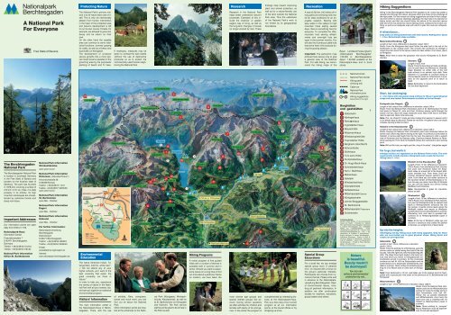
Recreation<br />
A total of 230 km (143 miles) of hiking<br />
paths and climbing trails make<br />
for ideal conditions for an enjoyable<br />
vacation. Starting with<br />
easy walks in the valleys to high<br />
mountain hikes lasting several<br />
days, there is something here for<br />
everyone. To complete the offer,<br />
mountain huts serving refreshments<br />
and overnight huts are<br />
open in the summer months. You<br />
will also find numerous cattle huts<br />
that serve fresh milk products during<br />
the grazing season.<br />
Important: The panoramic map<br />
pictured here serves only to give<br />
a general view of the <strong>National</strong><br />
<strong>Park</strong>. <strong>For</strong> safe hiking, we recommend<br />
the hiking maps of the<br />
Special Group<br />
Excursions<br />
<strong>For</strong> a small fee, we can arrange<br />
special group tours (7 persons<br />
min.) on request with a focus on<br />
the group’s particular interests.<br />
Participants can choose from numerous<br />
themes. Please write well<br />
in advance to the <strong>National</strong>parkverwaltung<br />
<strong>Berchtesgaden</strong>, Dept.<br />
of Environmental Issues, including<br />
all pertinent information. In<br />
addition we offer continuation<br />
studies for teachers, educators,<br />
group leaders and others.<br />
Bayer. Landesvermessungsamt:<br />
„<strong>National</strong>park <strong>Berchtesgaden</strong>“<br />
1:25.000 or „<strong>Berchtesgaden</strong>er<br />
Alpen“ 1:50.000 available at the<br />
<strong>National</strong>park-Haus and in book<br />
stores.<br />
<strong>National</strong> border<br />
<strong>National</strong> <strong>Park</strong> border<br />
Hiking path /<br />
climbing trail<br />
Cable-car<br />
<strong>National</strong> <strong>Park</strong><br />
information point<br />
Hiking suggestions<br />
Description to the right<br />
Publishing Details:<br />
Bavarian State Ministry of the Environmental<br />
Issues and Health – Published by: <strong>National</strong><br />
<strong>Park</strong> Administration <strong>Berchtesgaden</strong>, Doktorberg<br />
6, D-83471 <strong>Berchtesgaden</strong>, Tel: +49(0)8652/<br />
9686-0, Fax: +49(0)8652/968640 – E-Mail:<br />
poststelle@npv-bgd.bayern.de – Internet: www.<br />
nationalpark-berchtesgaden.de – Text: J. Seidenschwarz,<br />
B. Frühwald, A. Sanktjohanser –<br />
English translation: D. Harper, <strong>Berchtesgaden</strong> –<br />
Illustrations: Blaumeiser – Photos: H. Krafft, H.<br />
Munzig, K. Wagner, N. Hasenknopf, – Panoramic<br />
map: W. Krabichler – Layout: N. Hasenknopf &<br />
GL-Werbestudio – Printed by Plenk, <strong>Berchtesgaden</strong><br />
– 4th edition 2011.<br />
Printed on environmentally friendly paper.<br />
Nature<br />
is beautiful.<br />
Beauty mustn’t<br />
be destroyed!<br />
You too can<br />
enforce environmental<br />
protection by not...<br />
Hiking Suggestions<br />
Hiking in the <strong>Berchtesgaden</strong> <strong>National</strong> <strong>Park</strong> appeals to all: some may prefer a<br />
relaxed stroll through the valleys, whereas others are drawn to the challenge of<br />
the high peaks. <strong>For</strong> this reason our hiking suggestions are listed in four categories<br />
from which to choose. Generally speaking, the main idea is to exercise on<br />
alpine terrain and that one should follow the advice of the mountain rescue<br />
staff and of the hut personnel. Good walking shoes, waterproof and warm clothing,<br />
as well as an adequate map with which to plan the route are indispensable!<br />
A relaxed pace...<br />
Easy walks on well-groomed trails with little incline. Walking time: about<br />
1 - 2 hrs. Refreshment stops available.<br />
Malerwinkel-Rundweg<br />
Length of trail: 4 km; difference in elevation: about 100 m<br />
Route: From the Königssee boat dock follow the wide trail to the left of the<br />
boathouses to the outlook point. The circular trail continues on through a<br />
mixed mountain forest to the Jenner cable-car base station. From there, return<br />
to Königssee.<br />
Note: Allow time to enjoy the gorgeous view across Königssee to St. Bartholomew.<br />
Obersee<br />
Length of trail: 2 km<br />
Route: From the boat dock at Salet on Königssee<br />
the path leads via Mittersee to Obersee.<br />
Huge boulders on either side of the trail<br />
bear witness to an ancient rock slide. From<br />
Obersee it is possible to continue along to<br />
Fischunkelalm (open for refreshments in summer)<br />
on the opposite bank or to return to<br />
Salet.<br />
Note: Remember to return to the dock before<br />
the last boat departure!<br />
Short, but challenging:<br />
2 - 3 hrs hikes with occasional steep inclines for those in good physical<br />
shape and sure-footed. Refreshments available at the trail heads.<br />
Eiskapelle (Ice Chapel)<br />
Length of trail: about 6 km; difference in elevation: about 240 m<br />
Route: From the <strong>National</strong> <strong>Park</strong> information point at St. Bartholomew the level<br />
trail leads to Chapel St. John and Paul. Continue steeply uphill through the<br />
woods until you reach the large avalanche snow field at the foot of the Watzmann’s<br />
east wall. Return the same way.<br />
Note: The „ice chapel’s“ shape and size change from season to season and it<br />
is not always easy to discover! Please do not enter: the glacier door can easily<br />
collapse causing a fatal accident.<br />
Halsalm in the Klausbachtal<br />
Length of trail: about 6 km; difference in elevation: about 440 m<br />
Route: Passing the <strong>National</strong> <strong>Park</strong> information point near Hintersee follow the<br />
tarred road a short way before veering to the right. A continuous climb leads to<br />
Halsalm. A narrow path leads from the hut over the pasture to offer a superb<br />
view of Hintersee and the Ramsau valley. Continue towards Ramsau to Fernsebner<br />
parking lot. From here the footpath follows the road back to your starting<br />
point.<br />
Note: With a little luck you might spot the „king of the skies“: the golden eagle!<br />
Far to go, but worth it:<br />
Average inclines are negotiated on the <strong>National</strong> <strong>Park</strong>’s trails. The main<br />
requirements include stamina, hiking boots and a snack for the trail.<br />
Hiking time: 6 - 8 hrs.<br />
Bindalm in the Klausbachtal<br />
Length of trail: 12 km; difference in elevation:<br />
320 m Route: From the <strong>National</strong> <strong>Park</strong> information<br />
point near Hintersee follow the Klausbach<br />
valley on a level trail to the Engert Holzstube<br />
(wooden hut). From there, you’ll encounter<br />
somewhat steeper sections till Bindalm.<br />
From there you can either continue to<br />
the Austrian border at Hirschbichlpass or return<br />
the way you came. From May till October<br />
you can use the regular bus service linking<br />
Weißbach and Hintersee.<br />
Note: Klausbachtal is great for mountainbikers<br />
as well!<br />
Wimbachtal<br />
Length of trail: 18 km; difference in elevation:<br />
700 m Route: From the <strong>National</strong> <strong>Park</strong> information<br />
point at Wimbachbrücke an asphalt road<br />
leads to Wimbachklamm (entrance fee into<br />
the gorge). A gentle incline leads along the<br />
Wimbach stream and woods to Wimbachschloß<br />
which serves refreshments in summer.<br />
Alternating from rock bed to wooded trail,<br />
continue on to Wimbachgrieshütte (open in<br />
summer).<br />
Note: At the top of Wimbach valley one can<br />
discover a botanical rarity called the Spirken<br />
in German, an upright form of dwarf-pine!<br />
Up into the heights:<br />
Challenging full-day hiking tours with steep upgrades. Only for those<br />
who are sure-footed and in good physical shape. Hiking boots and<br />
snacks are prerequisites!<br />
Gotzenalm<br />
Length of trail: 18 km; difference in elevation:<br />
about 1100 m<br />
Route: From the parking lot at Königssee, pass the<br />
Jenner cable-car station along the road till the last<br />
houses. Take the right fork onto Hochbahnweg (Nr.<br />
493). The shady forest path leads to the forest service<br />
road which you follow to Königsbachalm (refreshments<br />
served in summer). At the crossroads<br />
continue on trail Nr. 493 via Gotzentalalm and via<br />
switch-backs on to Gotzenalm (refreshments available<br />
in summer). Return either to Hinterbrand parking<br />
lot or to Kessel dock or Salet dock on Königssee.<br />
Note: From Gotzenalm a 10 min. walk takes you to the lookout point at Feuerpalfen<br />
with a spectacular view down to the peninsula of St. Bartholomew and<br />
Königssee!<br />
Watzmannhaus<br />
Length of trail: 12 km; difference in elevation: about 1300 m<br />
Route: From the <strong>National</strong> <strong>Park</strong> information<br />
point at the Wimbachbrücke<br />
parking lot cross the bridge and turn<br />
right immediately onto trail 441.<br />
Follow this up passed Stubenalm<br />
and Mitterkaseralm. From here the<br />
road turns into a climbing trail via<br />
Falzalm to Watzmannhaus (open in<br />
summer).<br />
Note: Those wishing to „conquer“<br />
Mount Watzmann must be experienced,<br />
fit and well-equipped!
Flyer - NP für alle (e) - 04/2011 18.04.2011 14:52 Uhr Seite 2<br />
View of Lake Königssee and the St. Bartholomew peninsula. Photography: K. Wagner, <strong>National</strong> <strong>Park</strong>