mass falls in the Wachau-Danube Valley (Bohemian Massif
mass falls in the Wachau-Danube Valley (Bohemian Massif mass falls in the Wachau-Danube Valley (Bohemian Massif
infrastructure construction (roads, railways), which eventually had a dual effect on slope morphology: on the one hand, existing quarries were expanded and/or reactivated and, on the other hand, traffic infrastructure construction itself had an enormous impact on the area. With the advent of railway engineering, further difficulties were encountered especially at sites with working conditions comparable to alpine construction sites, as the planned routes led along steep rock slopes over long distances. Route construction often required high slope cuts or subtle engineering structures such as tunnels, bridges and retaining walls. Fig. 1 The extent of the Bohemian Massif in Austria. The box refers to the wider study area as shown in Fig. 4 Interdependences between quarrying and transport infrastructure construction eventually resulted in the development of unstable slopes. Besides several documented events within the 20th century the latest rockmass falls occurred in 2002 (Spitz, Fig. 2) and in 2009 (Dürnstein, Fig. 3). 30 m Fig. 2 Rock-mass fall near the village of Spitz (view towards WNW, photo: Müllegger, May 2010). 2
Fig. 3 Rock-mass fall near the town of Dürnstein (view towards SSE, photo: Müllegger, August 2009). Contrary to many alpine rock-mass falls in uninhabited areas (cf. Weidinger and Vortisch 2005) these two events in abandoned quarries caused major damage and still endanger transport infrastructure, which thus made geo-scientific investigations and protective measures necessary. Aim of this paper is to comment on geomorphological and geotechnical causes of these rockslides/rock-mass falls. Study area Geomorphic overview 40 m Between Passau and Krems, the Danube River runs along the southern edge of the Bohemian Massif, most of which is overlaid by Tertiary and Quaternary sediments. The exposed edge of the hilly fault residual plateau takes the form of a 500-600 m high piedmont stairway. Where higher mountain ridges reach the plateau’s margin, the river cuts down into the granites and gneisses of the crystalline basement, and carves out transverse valleys, such as the Wachau-Danube Valley (Kohl 1966). The morphogenesis of this river section was last analysed by Nagl and Verginis (1987), whose research focused on the palaeogeographic development of the catchment area. They suppose that the valley between Melk and Spitz (cf. Figs 1 and 4)was drained by the Enns River during the Tertiary, while the Danube River at that time run further north. In consequence of Late Tertiary tectonic processes the Danube River was captured by the Wachau-Enns River. The geomorphological appearance is characterised by the fact that the orientation of the river bed follows two conjugated major tectonic lineaments, striking approximately NE-SW and NW-SE. Wide basin and terraced landscapes are therefore non-existent in contrast to adjacent areas with Tertiary and Quaternary cover sediments. The tectonically fragmented and weakened rock mass along fault structures caused accelerated river erosion forming V-shaped valleys with relatively steep rock slopes and triggering large rockslides during the Oligocene. Matura (1983 and 1989) mapped a fossil slide mass deposited in the Wachau-Danube Valley near the village of Weißenkirchen (Fig. 4). He also interprets deposits of gneiss boulders in Weißenkirchen as rockslide sediments of the same age. In the present day, the rock slopes of the Bohemian Massif are usually considered to be stable. Gattinger (1980) assumes that mass movements are of minor relevance to the Bohemian Massif, owing to its relatively small relief ratio, and are limited to single rockfalls or local slope ruptures. 3 Dürnstein Danube river
- Page 1: Geomorphological and geotechnical c
- Page 5 and 6: Tectonically, the whole Bohemian Ma
- Page 7 and 8: There is not much information on fu
- Page 9 and 10: Fig. 8 Monitoring devices in the fo
- Page 11 and 12: Fig. 9 (a) Orientation of bedding p
- Page 13 and 14: Fig. 11 (a) Orientation of joints a
- Page 15 and 16: strength of eight MPa, and a fricti
- Page 17 and 18: Discussion Interpretation of failur
- Page 19 and 20: Conclusions There are two causes of
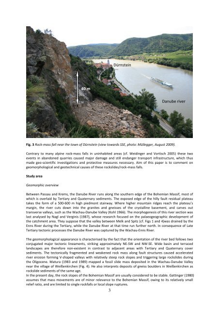
Fig. 3 Rock-<strong>mass</strong> fall near <strong>the</strong> town of Dürnste<strong>in</strong> (view towards SSE, photo: Müllegger, August 2009).<br />
Contrary to many alp<strong>in</strong>e rock-<strong>mass</strong> <strong>falls</strong> <strong>in</strong> un<strong>in</strong>habited areas (cf. Weid<strong>in</strong>ger and Vortisch 2005) <strong>the</strong>se two<br />
events <strong>in</strong> abandoned quarries caused major damage and still endanger transport <strong>in</strong>frastructure, which thus<br />
made geo-scientific <strong>in</strong>vestigations and protective measures necessary. Aim of this paper is to comment on<br />
geomorphological and geotechnical causes of <strong>the</strong>se rockslides/rock-<strong>mass</strong> <strong>falls</strong>.<br />
Study area<br />
Geomorphic overview<br />
40 m<br />
Between Passau and Krems, <strong>the</strong> <strong>Danube</strong> River runs along <strong>the</strong> sou<strong>the</strong>rn edge of <strong>the</strong> <strong>Bohemian</strong> <strong>Massif</strong>, most of<br />
which is overlaid by Tertiary and Quaternary sediments. The exposed edge of <strong>the</strong> hilly fault residual plateau<br />
takes <strong>the</strong> form of a 500-600 m high piedmont stairway. Where higher mounta<strong>in</strong> ridges reach <strong>the</strong> plateau’s<br />
marg<strong>in</strong>, <strong>the</strong> river cuts down <strong>in</strong>to <strong>the</strong> granites and gneisses of <strong>the</strong> crystall<strong>in</strong>e basement, and carves out<br />
transverse valleys, such as <strong>the</strong> <strong>Wachau</strong>-<strong>Danube</strong> <strong>Valley</strong> (Kohl 1966). The morphogenesis of this river section was<br />
last analysed by Nagl and Verg<strong>in</strong>is (1987), whose research focused on <strong>the</strong> palaeogeographic development of<br />
<strong>the</strong> catchment area. They suppose that <strong>the</strong> valley between Melk and Spitz (cf. Figs 1 and 4)was dra<strong>in</strong>ed by <strong>the</strong><br />
Enns River dur<strong>in</strong>g <strong>the</strong> Tertiary, while <strong>the</strong> <strong>Danube</strong> River at that time run fur<strong>the</strong>r north. In consequence of Late<br />
Tertiary tectonic processes <strong>the</strong> <strong>Danube</strong> River was captured by <strong>the</strong> <strong>Wachau</strong>-Enns River.<br />
The geomorphological appearance is characterised by <strong>the</strong> fact that <strong>the</strong> orientation of <strong>the</strong> river bed follows two<br />
conjugated major tectonic l<strong>in</strong>eaments, strik<strong>in</strong>g approximately NE-SW and NW-SE. Wide bas<strong>in</strong> and terraced<br />
landscapes are <strong>the</strong>refore non-existent <strong>in</strong> contrast to adjacent areas with Tertiary and Quaternary cover<br />
sediments. The tectonically fragmented and weakened rock <strong>mass</strong> along fault structures caused accelerated<br />
river erosion form<strong>in</strong>g V-shaped valleys with relatively steep rock slopes and trigger<strong>in</strong>g large rockslides dur<strong>in</strong>g<br />
<strong>the</strong> Oligocene. Matura (1983 and 1989) mapped a fossil slide <strong>mass</strong> deposited <strong>in</strong> <strong>the</strong> <strong>Wachau</strong>-<strong>Danube</strong> <strong>Valley</strong><br />
near <strong>the</strong> village of Weißenkirchen (Fig. 4). He also <strong>in</strong>terprets deposits of gneiss boulders <strong>in</strong> Weißenkirchen as<br />
rockslide sediments of <strong>the</strong> same age.<br />
In <strong>the</strong> present day, <strong>the</strong> rock slopes of <strong>the</strong> <strong>Bohemian</strong> <strong>Massif</strong> are usually considered to be stable. Gatt<strong>in</strong>ger (1980)<br />
assumes that <strong>mass</strong> movements are of m<strong>in</strong>or relevance to <strong>the</strong> <strong>Bohemian</strong> <strong>Massif</strong>, ow<strong>in</strong>g to its relatively small<br />
relief ratio, and are limited to s<strong>in</strong>gle rock<strong>falls</strong> or local slope ruptures.<br />
3<br />
Dürnste<strong>in</strong><br />
<strong>Danube</strong> river


