

The SWIFT BAT Software Guide Version 6.3 30 ... - HEASARC - Nasa
The SWIFT BAT Software Guide Version 6.3 30 ... - HEASARC - Nasa
The SWIFT BAT Software Guide Version 6.3 30 ... - HEASARC - Nasa

You also want an ePaper? Increase the reach of your titles
YUMPU automatically turns print PDFs into web optimized ePapers that Google loves.
166 APPENDIX D. <strong>BAT</strong> SOFTWARE TOOL REFERENCE<br />
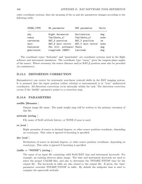
other coordinate systems, then the meaning of the ra and dec parameters changes according to the<br />
following table:<br />
COORD_TYPE RA parameter DEC parameter Units<br />
-----------------------------------------------------------sky<br />
Right Ascension Declination deg<br />
tanxy Tan(theta_x) Tan(theta_y) none<br />
cartesian <strong>BAT</strong>_X position <strong>BAT</strong>_Y position cm<br />
unit <strong>BAT</strong>_X unit vector <strong>BAT</strong>_Y unit vector none<br />
fswlonlat Phi (flt. software) <strong>The</strong>ta deg<br />
grmclonlat Longitude (GRMC) Latitude deg<br />
<strong>The</strong> coordinate types “fswlonlat” and “grmclonlat” are coordinate systems used in the flight<br />
software and instrument simulators. <strong>The</strong> coordinate type “tanxy” gives the tangent-plane angles<br />
of the source. Where necessary the source distance and/or <strong>BAT</strong> Z position must also be provided<br />
(in centimeters).<br />
D.15.5 DISTORTION CORRECTION<br />
Batmaskwtevt can correct for systematic non-linear centroid shifts in the <strong>BAT</strong> imaging system.<br />
It is assumed that the input position (either celestial or instrumental) is in “true” undistorted<br />
coordinates. All distortion corrections occur internally within the task. <strong>The</strong> distortion correction<br />
occurs if the ‘distfile’ parameter points to a correction map.<br />
D.15.6 PARAMETERS<br />
outfile [filename ]<br />
Output image file name. <strong>The</strong> mask weight map will be written to the primary extension of<br />
this file.<br />
attitude [string ]<br />
ra [real ]<br />
File name of Swift attitude history, or NONE if none is used.<br />
Right ascension of source in decimal degrees, or other source position coordinate, depending<br />
on coord type. This value is ignored if incatalog is specified.<br />
dec [real ]<br />
Declination of source in decimal degrees, or other source position coordinate, depending on<br />
coord type. This value is ignored if incatalog is specified.<br />
(infile = “NONE”) [string ]<br />
<strong>The</strong> name of an input file containing valid Swift/<strong>BAT</strong> time and instrument keywords. For<br />
example, an existing detector plane image. <strong>The</strong> time and instrument keywords are used to<br />
select the proper CALDB files, and also to determine the TSTART/TSTOP time for the<br />
output file. <strong>The</strong> keywords in infile are also cloned to the output file. If given, the ‘time’<br />
parameter overrides TSTART/TSTOP in infile. By default the midpoint time is used to<br />
compute the spacecraft attitude.