

Synthesis of late Paleozoic and Mesozoic eolian deposits of the ...
Synthesis of late Paleozoic and Mesozoic eolian deposits of the ...
Synthesis of late Paleozoic and Mesozoic eolian deposits of the ...

You also want an ePaper? Increase the reach of your titles
YUMPU automatically turns print PDFs into web optimized ePapers that Google loves.
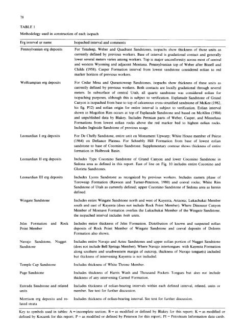
78<br />
TABLE 1<br />
Methodology used in construction <strong>of</strong> each isopach<br />
Erg interval or name Isopached interval <strong>and</strong> comments<br />
Pennsylvanian erg <strong>deposits</strong><br />
Wolfcampian erg <strong>deposits</strong><br />
Leonardian I erg <strong>deposits</strong><br />
Leonardian 11 erg <strong>deposits</strong><br />
Leonardian III erg <strong>deposits</strong><br />
Wingate S<strong>and</strong>stone<br />
Jelm Formation <strong>and</strong> Rock<br />
Point Member<br />
Navajo S<strong>and</strong>stone, Nugget<br />
S<strong>and</strong>stone<br />
Temple Cap S<strong>and</strong>stone<br />
Page S<strong>and</strong>stone<br />
Entrada S<strong>and</strong>stone <strong>and</strong> re<strong>late</strong>d<br />
units<br />
Morrison erg <strong>deposits</strong> <strong>and</strong> re-<br />
<strong>late</strong>d strata<br />
For Tensleep, Weber <strong>and</strong> Quadrant S<strong>and</strong>stones, isopachs show thickness <strong>of</strong> those units as<br />
currently defined by previous workers. Base <strong>of</strong> interval is gradational contact <strong>and</strong> generally<br />
lower several meters varies among workers. Top is major unconformity across most <strong>of</strong> central<br />
<strong>and</strong> western Wyoming <strong>and</strong> adjacent Montana. Pennsylvanian top <strong>of</strong> Weber after Bissell <strong>and</strong><br />
Childs (1958). Casper Formation interval from lowest s<strong>and</strong>stone considered <strong>eolian</strong> to red<br />
marker horizon <strong>of</strong> previous workers.<br />
For Cedar Mesa <strong>and</strong> Queantoweap S<strong>and</strong>stones, isopachs show thickness <strong>of</strong> <strong>the</strong>se units as<br />
currently defined by previous workers. Both contacts are locally gradational through several<br />
meters. In subsurface <strong>of</strong> central Utah, all quartz s<strong>and</strong>stone was considered <strong>eolian</strong> for<br />
isopaching purposes, although this is subject to verification. Esplanade S<strong>and</strong>stone <strong>of</strong> Gr<strong>and</strong><br />
Canyon is isopached from base to top <strong>of</strong> calcareous cross-stratified s<strong>and</strong>stone <strong>of</strong> McKee (1982,<br />
his fig. P12) <strong>and</strong> <strong>eolian</strong> origin for entire interval is subject to verification. Eolian interval<br />
shown in Mogollon Rim occurs at top <strong>of</strong> Esplanade S<strong>and</strong>stone <strong>and</strong> based on McAllen (1984)<br />
<strong>and</strong> unpublished data by Blakey. Includes Permian parts <strong>of</strong> Weber, Casper, <strong>and</strong> Minnelusa<br />
Formations from lowest <strong>eolian</strong> rocks above <strong>the</strong> red marker bed to highest <strong>eolian</strong> rocks.<br />
Includes Ingleside S<strong>and</strong>stone <strong>of</strong> previous usage.<br />
For De Chelly S<strong>and</strong>stone, entire unit on Monument Upwarp; White House member <strong>of</strong> Peirce<br />
(1964) on Defiance P<strong>late</strong>au. For Schnebly Hill Formation from base <strong>of</strong> lowest <strong>eolian</strong><br />
s<strong>and</strong>stone to base <strong>of</strong> Coconino S<strong>and</strong>stone. Supplementary contour shows thickness <strong>of</strong> entire<br />
formation in Holbrook Basin.<br />
Includes Type Coconino S<strong>and</strong>stone <strong>of</strong> Gr<strong>and</strong> Canyon <strong>and</strong> lower Coconino S<strong>and</strong>stone in<br />
Sedona area as defined in this report. East <strong>of</strong> line on Fig. 10 includes entire Coconino <strong>and</strong><br />
Glorieta S<strong>and</strong>stones.<br />
Includes Lyons S<strong>and</strong>stone as recognized by previous workers. Includes eastern phase <strong>of</strong><br />
Toroweap Formation (Rawson <strong>and</strong> Turner-Peterson, 1980) <strong>and</strong> coeval rocks; White Rim<br />
S<strong>and</strong>stone <strong>of</strong> Utah as currently defined; upper Coconino S<strong>and</strong>stone <strong>of</strong> Sedona area as herein<br />
defined.<br />
Includes entire Wingate S<strong>and</strong>stone north <strong>and</strong> west <strong>of</strong> Kayenta, Arizona; Lukachukai Member<br />
south <strong>and</strong> east <strong>of</strong> Kayenta (does not include Rock Point Member). Where Dinosaur Canyon<br />
Member <strong>of</strong> Moenave Formation overlies <strong>the</strong> Lukachukai Member <strong>of</strong> <strong>the</strong> Wingate S<strong>and</strong>stone,<br />
<strong>the</strong> isopached interval includes both units.<br />
Includes entire thickness <strong>of</strong> Jelm Formation. Distribution <strong>of</strong> known <strong>and</strong> suspected <strong>eolian</strong><br />
<strong>deposits</strong> <strong>of</strong> Rock Point Member <strong>of</strong> Wingate S<strong>and</strong>stone <strong>and</strong> coeval <strong>deposits</strong> <strong>of</strong> Dolores<br />
Formation also shown.<br />
Includes entire Navajo <strong>and</strong> Aztec S<strong>and</strong>stones <strong>and</strong> upper <strong>eolian</strong> portion <strong>of</strong> Nugget S<strong>and</strong>stone<br />
(does not include Bell Springs Member). Where Navajo intertongues with Kayenta Formation<br />
along sou<strong>the</strong>rn <strong>and</strong> southwestern margin <strong>of</strong> outcrop, thickness <strong>of</strong> Navajo tongue(s) included<br />
but thickness <strong>of</strong> intervening Kayenta is not included.<br />
Includes thickness <strong>of</strong> White Throne Member.<br />
Includes thickness <strong>of</strong> Harris Wash <strong>and</strong> Thous<strong>and</strong> Pockets Tongues but does not include<br />
thickness <strong>of</strong> any intervening Carmel Formation.<br />
Includes thickness <strong>of</strong> <strong>eolian</strong>-bearing intervals within each defined interval, re<strong>late</strong>d, units or<br />
member. See text for fur<strong>the</strong>r discussion.<br />
Includes thickness <strong>of</strong> <strong>eolian</strong>-bearing interval. See text for fur<strong>the</strong>r discussion.<br />
Key to symbols used in tables: A = incomplete section; B = as modified or defined by Blakey for this report; K = as modified or<br />
defined by Kocurek for this report; P = as modified or defined by Peterson for this report; PI = Petroleum Information data cards.


