

Synthesis of late Paleozoic and Mesozoic eolian deposits of the ...
Synthesis of late Paleozoic and Mesozoic eolian deposits of the ...
Synthesis of late Paleozoic and Mesozoic eolian deposits of the ...

Create successful ePaper yourself
Turn your PDF publications into a flip-book with our unique Google optimized e-Paper software.
The presentation <strong>of</strong> each <strong>eolian</strong>-bearing se-<br />
quence will follow <strong>the</strong> same format. Description in<br />
<strong>the</strong> text will be brief, especially in cases where <strong>the</strong><br />
rocks are well described in previous literature.<br />
Emphasis will be placed on facies <strong>and</strong> geometric<br />
relations <strong>of</strong> <strong>the</strong> <strong>eolian</strong> units, especially <strong>late</strong>ral con-<br />
figurations. We will show that few <strong>eolian</strong> <strong>deposits</strong><br />
are simple layer-cake s<strong>and</strong> bodies, <strong>and</strong> ra<strong>the</strong>r that<br />
most are complex units that change vertically <strong>and</strong><br />
<strong>late</strong>rally <strong>and</strong> show strong diachronous characteris-<br />
tics. Preliminary <strong>and</strong> general interpretations <strong>of</strong> erg<br />
geometry will be <strong>of</strong>fered, although this topic is<br />
more completely discussed in o<strong>the</strong>r papers in this<br />
volume.<br />
Isopachs alone are insufficient for interpreta-<br />
tion <strong>of</strong> complex s<strong>and</strong>stone-body geometry. Most<br />
<strong>of</strong> <strong>the</strong> isopach maps have additional symbols for<br />
interpretation <strong>of</strong> <strong>eolian</strong> s<strong>and</strong>stone-body geometry.<br />
The lines that show percentage <strong>of</strong> <strong>eolian</strong> <strong>deposits</strong><br />
document trends <strong>of</strong> increasing or decreasing <strong>eolian</strong><br />
sediment within an interval. The bounding lines <strong>of</strong><br />
<strong>the</strong> <strong>eolian</strong> interval also aid interpretation <strong>of</strong> <strong>the</strong><br />
maps. Zero lines indicate wedge-out <strong>of</strong> an <strong>eolian</strong><br />
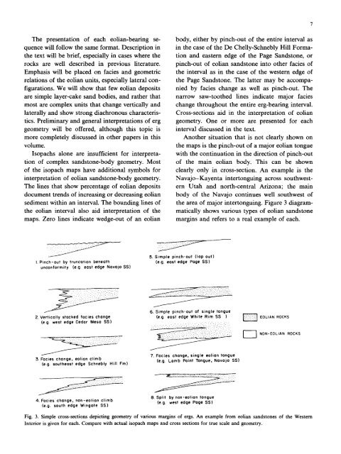
I. Pinch-out by truncation beneath<br />
unconformity (e.g. east edge Navajo SS)<br />
2. Vertically stacked facies change<br />
(e.g. west edge Cedar Mesa SS)<br />
~ ' ~ ~ i<br />
3. Facies change, <strong>eolian</strong> climb<br />
(e.g. sou<strong>the</strong>ast edge Schnebly Hill Fro)<br />
4. Facies change, non-<strong>eolian</strong> climb<br />
(e.g. south edge Wingate SSI<br />
body, ei<strong>the</strong>r by pinch-out <strong>of</strong> <strong>the</strong> entire interval as<br />
in <strong>the</strong> case <strong>of</strong> <strong>the</strong> De Chelly-Schnebly Hill Forma-<br />
tion <strong>and</strong> eastern edge <strong>of</strong> <strong>the</strong> Page S<strong>and</strong>stone, or<br />
pinch-out <strong>of</strong> <strong>eolian</strong> s<strong>and</strong>stone into o<strong>the</strong>r facies <strong>of</strong><br />
<strong>the</strong> interval as in <strong>the</strong> case <strong>of</strong> <strong>the</strong> western edge <strong>of</strong><br />
<strong>the</strong> Page S<strong>and</strong>stone. The latter may be accompa-<br />
nied by facies change as well as pinch-out. The<br />
narrow saw-too<strong>the</strong>d lines indicate major facies<br />
change throughout <strong>the</strong> entire erg-beafing interval.<br />
Cross-sections aid in <strong>the</strong> interpretation <strong>of</strong> <strong>eolian</strong><br />
geometry. One or more are presented for each<br />
interval discussed in <strong>the</strong> text.<br />
Ano<strong>the</strong>r situation that is not clearly shown on<br />
<strong>the</strong> maps is <strong>the</strong> pinch-out <strong>of</strong> a major <strong>eolian</strong> tongue<br />
with <strong>the</strong> continuation in <strong>the</strong> direction <strong>of</strong> pinch-out<br />
<strong>of</strong> <strong>the</strong> main <strong>eolian</strong> body. This can be shown<br />
clearly only in cross-section. An example is <strong>the</strong><br />
Navajo-Kayenta intertonguing across southwest-<br />
ern Utah <strong>and</strong> north-central Arizona; <strong>the</strong> main<br />
body <strong>of</strong> <strong>the</strong> Navajo continues well southwest <strong>of</strong><br />
<strong>the</strong> area <strong>of</strong> major intertonguing. Figure 3 diagram-<br />
matically shows various types <strong>of</strong> <strong>eolian</strong> s<strong>and</strong>stone<br />
margins <strong>and</strong> refers to a real example <strong>of</strong> each.<br />
5. Simple pinch-out (lap out)<br />
(e.g. east edge Page SS)<br />
6. Simple pinch-out <strong>of</strong> single tongue<br />
(e.g. east edge White Rim SS )<br />
.... ..... "... : . ~. "/'."..'. : .'"... ~ ".' : :.;~i :': .".<br />
'~\'"' .... "' ' " ' i'.-..:~::'::':?.""'..<br />
7. Facies change, single <strong>eolian</strong> tongue<br />
(e.g. Lamb Point Tongue, Navajo SS]<br />
B. Split by non-<strong>eolian</strong> tongue<br />
(e.g. west edge Page SS)<br />
EOLIAN ROCKS<br />
I I NON-EOLIAN ROCKS<br />
Fig. 3. Simple cross-sections depicting geometry <strong>of</strong> various margins <strong>of</strong> ergs. An example from <strong>eolian</strong> s<strong>and</strong>stones <strong>of</strong> <strong>the</strong> Western<br />
Interior is given for each. Compare with actual isopach maps <strong>and</strong> cross sections for true scale <strong>and</strong> geometry.


