GEOTOUR GUIDE - City of Kamloops
GEOTOUR GUIDE - City of Kamloops GEOTOUR GUIDE - City of Kamloops
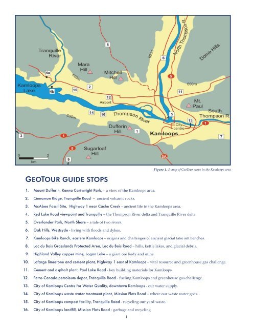
GeoTour Guide sTops 1. Mount Dufferin, Kenna Cartwright Park, – a view of the Kamloops area. 2. Cinnamon Ridge, Tranquille Road – ancient volcanic rocks. 3. McAbee Fossil Site, Highway 1 near Cache Creek – ancient life in the Kamloops area. 1 Figure 1. A map of GeoTour stops in the Kamloops area 4. Red Lake Road viewpoint and Tranquille – the Thompson River delta and Tranquille River delta. 5. Overlander Park, North Shore – a tale of two rivers. 6. Oak Hills, Westsyde - living with floods and dykes. 7. Kamloops Bike Ranch, eastern Kamloops – origins and challenges of ancient glacial lake silt benches. 8. Lac du Bois Grasslands Protected Area, Lac du Bois Road – hills, kettle lakes, and glacial debris. 9. Highland Valley copper mine, Logan Lake – a giant ore body and mine. 10. Lafarge limestone and cement plant, Highway 1 east of Kamloops – vital resource and greenhouse gas challenge. 11. Cement and asphalt plant, Paul Lake Road - key building materials for Kamloops. 12. Petro-Canada petroleum depot, Tranquille Road - fueling Kamloops and greenhouse gas challenge. 13. City of Kamloops Centre for Water Quality, downtown Kamloops - our water supply. 14. City of Kamloops waste water treatment plant, Mission Flats Road – where our waste water goes. 15. City of Kamloops compost facility, Tranquille Road - recycling our yard waste. 16. City of Kamloops landfill, Mission Flats Road - garbage and recycling.
Figure 2. View to the north of Kamloops and the North Thompson River valley from the City of Kamloops scenic lookout on Columbia Street. (Photo by R. Turner) Kamloops, meeTinG of The WaTers We live within the great Interior Plateau of British Columbia where the two major tributaries of the Thompson River join and flow together into Kamloops Lake. To the Secwepemc or Shuswap people, this place is “Tk’emlups”, meaning ‘meeting of the waters’. Two major highways and railways follow these river valleys and also converge here, making it a transportation crossroads. Kamloops is a meeting place in other ways. Grasslands and forests, the two major ecosystems of southern BC are found here. The boundary between the gently rolling Interior Plateau and more rugged Shuswap Highlands lies just east of the city. And as we will discuss in this guide, this landscape boundary follows a geological boundary between ancient North America and “exotic” Pacific islands that make up the landmass of western British Columbia. Kamloops, like any other community, is dependent on the Earth for water, food, materials, and energy. Not only does the Earth provide resources, but it accepts our wastes. This GeoTour field guide explores how the community of Kamloops lives on, lives from, and lives with, the land. What earth materials underlie this landscape and how do they influence our use of the land? What nearby mineral resources do we depend on? What earth hazards do we need to accommodate or avoid? Where does our water supply come from? Where does our waste water go? Where does our garbage go? Where does the energy that fuels our lives come from? The answers to these questions illustrate how our landscape sustains our lives. Figure 3. Kamloops depends on the Earth to provide resources that flow into the city, and to assimilate wastes that flow out. This guide takes us on a tour of the geological landscape of Kamloops. Many GeoTour locations may be familiar to you, but this guide hopes to provide you with new way of looking at the land, with what we might call “landscape eyes”. 2
- Page 1: GeoTour Guide for Kamloops, BriTish
- Page 5 and 6: hoW did all These GeoloGiCal maTeri
- Page 7 and 8: leT’s sTarT The GeoTour of Kamloo
- Page 9 and 10: hoW Would a GeoGrapher desCriBe Kam
- Page 11 and 12: Figure 12a. The stream has cut a de
- Page 13 and 14: Figure 15. Layers of dark mudstone
- Page 15 and 16: Figure 18. A view from the end of T
- Page 17 and 18: Tracing the North and South Thompso
- Page 19 and 20: disaster on the North Thompson and
- Page 21 and 22: Figure 30a. An artistic rendering o
- Page 23 and 24: (sTop 8) laC du Bois Grasslands pro
- Page 25 and 26: An orebody is an unusual concentrat
- Page 27 and 28: (sTop 10) lafarGe limesTone quarry
- Page 29 and 30: (sTop 12) peTro-Canada peTroleum sT
- Page 31 and 32: (sTop 13) Where does our WaTer Come
- Page 33 and 34: (sTop 14) Where does our WasTe WaTe
- Page 35 and 36: (sTop 16) Where does our GarBaGe Go
GeoTour Guide sTops<br />
1. Mount Dufferin, Kenna Cartwright Park, – a view <strong>of</strong> the <strong>Kamloops</strong> area.<br />
2. Cinnamon Ridge, Tranquille Road – ancient volcanic rocks.<br />
3. McAbee Fossil Site, Highway 1 near Cache Creek – ancient life in the <strong>Kamloops</strong> area.<br />
1<br />
Figure 1. A map <strong>of</strong> GeoTour stops in the <strong>Kamloops</strong> area<br />
4. Red Lake Road viewpoint and Tranquille – the Thompson River delta and Tranquille River delta.<br />
5. Overlander Park, North Shore – a tale <strong>of</strong> two rivers.<br />
6. Oak Hills, Westsyde - living with floods and dykes.<br />
7. <strong>Kamloops</strong> Bike Ranch, eastern <strong>Kamloops</strong> – origins and challenges <strong>of</strong> ancient glacial lake silt benches.<br />
8. Lac du Bois Grasslands Protected Area, Lac du Bois Road – hills, kettle lakes, and glacial debris.<br />
9. Highland Valley copper mine, Logan Lake – a giant ore body and mine.<br />
10. Lafarge limestone and cement plant, Highway 1 east <strong>of</strong> <strong>Kamloops</strong> – vital resource and greenhouse gas challenge.<br />
11. Cement and asphalt plant, Paul Lake Road - key building materials for <strong>Kamloops</strong>.<br />
12. Petro-Canada petroleum depot, Tranquille Road - fueling <strong>Kamloops</strong> and greenhouse gas challenge.<br />
13. <strong>City</strong> <strong>of</strong> <strong>Kamloops</strong> Centre for Water Quality, downtown <strong>Kamloops</strong> - our water supply.<br />
14. <strong>City</strong> <strong>of</strong> <strong>Kamloops</strong> waste water treatment plant, Mission Flats Road – where our waste water goes.<br />
15. <strong>City</strong> <strong>of</strong> <strong>Kamloops</strong> compost facility, Tranquille Road - recycling our yard waste.<br />
16. <strong>City</strong> <strong>of</strong> <strong>Kamloops</strong> landfill, Mission Flats Road - garbage and recycling.


