GEOTOUR GUIDE - City of Kamloops
GEOTOUR GUIDE - City of Kamloops
GEOTOUR GUIDE - City of Kamloops

Create successful ePaper yourself
Turn your PDF publications into a flip-book with our unique Google optimized e-Paper software.
Tracing the North and South Thompson Rivers back to their headwaters reveals that both rivers drain the rugged Columbia<br />
Mountains and its many glaciers. Streams that flow from these glaciers are very muddy because they carry a load <strong>of</strong> glacial<br />
silt (finely ground rock). Both the North and South Thompson drainages flow through many large lakes. In this way, both river<br />
systems are similar. However, the lakes <strong>of</strong> the North Thompson River occur only in the Wells Gray Park area, drained by the<br />
Clearwater River. Note the name “Clearwater River”. Rivers that flow into lakes enter a giant settling pond – mud and silt carried<br />
along by energetic river flow settles in the still water to the lake bottom. However, a large part <strong>of</strong> the North Thompson River does<br />
not flow through large lakes and therefore it carries the mud and silt eroded from mountain glaciers all the way to <strong>Kamloops</strong><br />
Lake. In contrast, the headwater streams <strong>of</strong> the South Thompson River all flow into the giant Shuswap Lake system, filtering their<br />
waters. The South Thompson River flows out <strong>of</strong> Shuswap Lake as clear and warm as the Shuswap lakes. The only way for mud<br />
to get into the South Thompson River is through tributaries that enter the river downstream from Shuswap Lake. Chase Creek<br />
is one such stream and floods on Chase Creek can occasionally create muddy water in the South Thompson River. Such muddy<br />
water is important to <strong>Kamloops</strong> because the <strong>City</strong> draws its domestic water from the South Thompson River, and for many years<br />
muddy water (turbidity) created problems for water treatment (see Stop 13).<br />
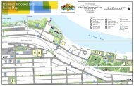
How to get to overlander parK: Cross the Overlander Bridge to the North Shore from the Victoria<br />
Street and the <strong>City</strong> Centre. Turn right on Fort Avenue and then again on Schubert Drive. At the end <strong>of</strong> Schubert, turn<br />
right on Beach Avenue and then left on Kitchener Crescent. There is a parking lot at the park. Cross to the River Walk<br />
trail along the dyke above the river bank. Look for stairs to the sand and gravel beach and bar below.<br />
16