

General Plan Land Use Diagram - San Joaquin County General ...
General Plan Land Use Diagram - San Joaquin County General ...
General Plan Land Use Diagram - San Joaquin County General ...

You also want an ePaper? Increase the reach of your titles
YUMPU automatically turns print PDFs into web optimized ePapers that Google loves.
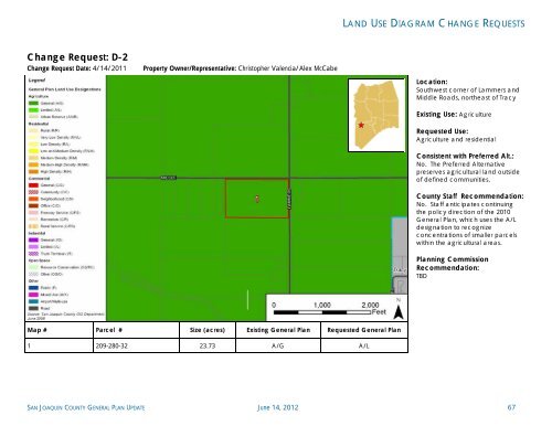
Change Request: D-2<br />
Change Request Date: 4/14/2011 Property Owner/Representative: Christopher Valencia/Alex McCabe<br />
Map # Parcel # Size (acres) Existing <strong>General</strong> <strong>Plan</strong> Requested <strong>General</strong> <strong>Plan</strong><br />
1 209-280-32 23.73 A/G A/L<br />
LAND USE DIAGRAM CHANGE REQUESTS<br />
Location:<br />
Southwest corner of Lammers and<br />
Middle Roads, northeast of Tracy<br />
Existing <strong>Use</strong>: Agriculture<br />
Requested <strong>Use</strong>:<br />
Agriculture and residential<br />
Consistent with Preferred Alt.:<br />
No. The Preferred Alternative<br />
preserves agricultural land outside<br />
of defined communities.<br />
<strong>County</strong> Staff Recommendation:<br />
No. Staff anticipates continuing<br />
the policy direction of the 2010<br />
<strong>General</strong> <strong>Plan</strong>, which uses the A/L<br />
designation to recognize<br />
concentrations of smaller parcels<br />
within the agricultural areas.<br />
<strong>Plan</strong>ning Commission<br />
Recommendation:<br />
TBD<br />
SAN JOAQUIN COUNTY GENERAL PLAN UPDATE June 14, 2012 67