

General Plan Land Use Diagram - San Joaquin County General ...
General Plan Land Use Diagram - San Joaquin County General ...
General Plan Land Use Diagram - San Joaquin County General ...

You also want an ePaper? Increase the reach of your titles
YUMPU automatically turns print PDFs into web optimized ePapers that Google loves.
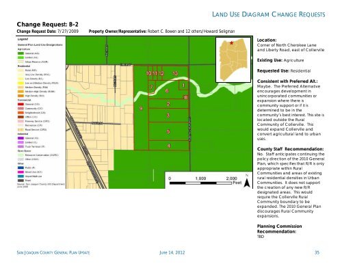
Change Request: B-2<br />
Change Request Date: 7/27/2009 Property Owner/Representative: Robert C. Bowen and 12 others/Howard Seligman<br />
LAND USE DIAGRAM CHANGE REQUESTS<br />
Location:<br />
Corner of North Cherokee Lane<br />
and Liberty Road, east of Collierville<br />
Existing <strong>Use</strong>: Agriculture<br />
Requested <strong>Use</strong>: Residential<br />
Consistent with Preferred Alt.:<br />
Maybe. The Preferred Alternative<br />
encourages development in<br />
unincorporated communities or<br />
expansion where there is<br />
community support or if it is<br />
determined to be in the<br />
community’s best interest. This site is<br />
located outside the Rural<br />
Community of Collierville. This<br />
would expand Collierville and<br />
convert agricultural land to urban<br />
uses.<br />
<strong>County</strong> Staff Recommendation:<br />
No. Staff anticipates continuing the<br />
policy direction of the 2010 <strong>General</strong><br />
<strong>Plan</strong>, which specifies that R/R is only<br />
appropriate within Rural<br />
Communities and areas of existing<br />
rural residential densities in Urban<br />
Communities. It does not support<br />
the creation of any new R/R<br />
designated areas. This would<br />
require the Collierville Rural<br />
Community boundary to be<br />
expanded. The 2010 <strong>General</strong> <strong>Plan</strong><br />
discourages Rural Community<br />
expansions.<br />
<strong>Plan</strong>ning Commission<br />
Recommendation:<br />
TBD<br />
SAN JOAQUIN COUNTY GENERAL PLAN UPDATE June 14, 2012 35