

General Plan Land Use Diagram - San Joaquin County General ...
General Plan Land Use Diagram - San Joaquin County General ...
General Plan Land Use Diagram - San Joaquin County General ...

You also want an ePaper? Increase the reach of your titles
YUMPU automatically turns print PDFs into web optimized ePapers that Google loves.
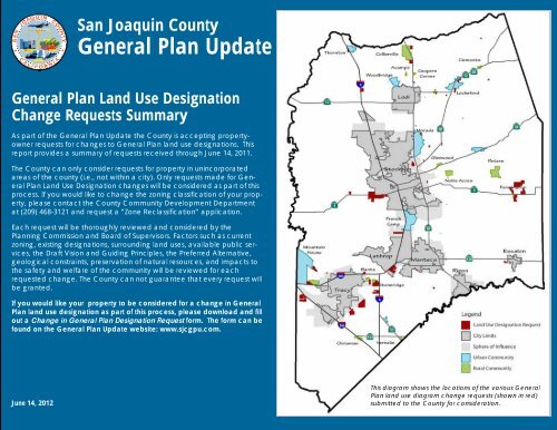
<strong>San</strong> <strong>Joaquin</strong> <strong>County</strong><br />
<strong>General</strong> <strong>Plan</strong> Update<br />
<strong>General</strong> <strong>Plan</strong> <strong>Land</strong> <strong>Use</strong> Designation<br />
Change Requests Summary<br />
As part of the <strong>General</strong> <strong>Plan</strong> Update the <strong>County</strong> is accepting propertyowner<br />
requests for changes to <strong>General</strong> <strong>Plan</strong> land use designations. This<br />
report provides a summary of requests received through June 14, 2011.<br />
The <strong>County</strong> can only consider requests for property in unincorporated<br />
areas of the county (i.e., not within a city). Only requests made for <strong>General</strong><br />
<strong>Plan</strong> <strong>Land</strong> <strong>Use</strong> Designation changes will be considered as part of this<br />
process. If you would like to change the zoning classification of your property,<br />
please contact the <strong>County</strong> Community Development Department<br />
at (209) 468-3121 and request a “Zone Reclassification” application.<br />
Each request will be thoroughly reviewed and considered by the<br />
<strong>Plan</strong>ning Commission and Board of Supervisors. Factors such as current<br />
zoning, existing designations, surrounding land uses, available public services,<br />
the Draft Vision and Guiding Principles, the Preferred Alternative,<br />
geological constraints, preservation of natural resources, and impacts to<br />
the safety and welfare of the community will be reviewed for each<br />
requested change. The <strong>County</strong> can not guarantee that every request will<br />
be granted.<br />
If you would like your property to be considered for a change in <strong>General</strong><br />
<strong>Plan</strong> land use designation as part of this process, please download and fill<br />
out a Change in <strong>General</strong> <strong>Plan</strong> Designation Request form. The form can be<br />
found on the <strong>General</strong> <strong>Plan</strong> Update website: www.sjcgpu.com.<br />
June 14, 2012<br />
This diagram shows the locations of the various <strong>General</strong><br />
<strong>Plan</strong> land use diagram change requests (shown in red)<br />
submitted to the <strong>County</strong> for consideration.
S AN JOAQUIN COUNTY GENERAL PLAN UPDATE<br />
Table of Contents<br />
A. Commercial, Industrial, and Employment-Related <strong>Land</strong> <strong>Use</strong> Requests ................................................. 3<br />
B. Residential <strong>Land</strong> <strong>Use</strong> Requests ..................................................................................................................... 33<br />
C. Multiple <strong>Use</strong> (Residential and Commercial) Requests ............................................................................. 62<br />
D. Agricultural <strong>Land</strong> <strong>Use</strong> Requests ................................................................................................................... 66<br />
E. Miscellaneous Requests ................................................................................................................................. 72<br />
2 June 14, 2012 SAN JOAQUIN COUNTY GENERAL PLAN UPDATE
LAND USE DIAGRAM CHANGE REQUESTS<br />
A. Commercial, Industrial, and Employment-Related <strong>Land</strong> <strong>Use</strong> Requests<br />
Change Request: A-1<br />
Change Request Date: 12/29/2008 Property Owner/Representative: Anthony F. Souza<br />
Map # Parcel # Size (acres) Existing <strong>General</strong> <strong>Plan</strong> Requested <strong>General</strong> <strong>Plan</strong><br />
1 209-310-07 64.42 A/G Industrial<br />
2 209-310-06 69.82 A/G Industrial<br />
3 209-310-03 45.52 A/G Industrial<br />
Location:<br />
Between Bethany Road, Byron<br />
Road, the railroad, and Wicklund<br />
Road (east of Mountain House)<br />
Existing <strong>Use</strong>: Agriculture<br />
Requested <strong>Use</strong>: Industrial<br />
Consistent with Preferred Alt.:<br />
No. The Preferred Alternative<br />
encourages commercial and<br />
employment uses along major<br />
highways provided that appropriate<br />
access and adequate infrastructure<br />
and services are provided;<br />
however, this site is not located<br />
along a major highway.<br />
<strong>County</strong> Staff Recommendation:<br />
No. This change is located<br />
adjacent to Mountain House, where<br />
a surplus of employment<br />
designated land currently exists. This<br />
change could undermine<br />
implementation of the Mountain<br />
House Master <strong>Plan</strong>.<br />
Also, this proposed development<br />
may not connect to the Mountain<br />
House CSD. Staff would recommend<br />
conditions requiring infrastructure<br />
and services to be funded,<br />
constructed, and maintained by the<br />
developer/ property owner.<br />
<strong>Plan</strong>ning Commission<br />
Recommendation:<br />
TBD<br />
SAN JOAQUIN COUNTY GENERAL PLAN UPDATE June 14, 2012 3
S AN JOAQUIN COUNTY GENERAL PLAN UPDATE<br />
Change Request: A-2<br />
Change Request Date: 3/31/2010 Property Owner/Representative: Artemis Vourakis<br />
Map # Parcel # Size (acres) Existing <strong>General</strong> <strong>Plan</strong> Requested <strong>General</strong> <strong>Plan</strong><br />
1 228-030-28 10.13 A/G C/G<br />
Location:<br />
East of Manteca, south of SR 120<br />
Existing <strong>Use</strong>: Agriculture<br />
Requested <strong>Use</strong>: Commercial<br />
Consistent with Preferred Alt.:<br />
No. The Preferred Alternative<br />
preserves agricultural land outside<br />
of defined communities. This<br />
request would convert agricultural<br />
land to urban uses in an area<br />
outside Manteca. Also it would not<br />
promote compact, infill<br />
development in Manteca.<br />
<strong>County</strong> Staff Recommendation:<br />
No. This would expand<br />
unincorporated development<br />
adjacent to Manteca, within its<br />
Area of Interest. This area lacks<br />
infrastructure and services to meet<br />
proposed demand.<br />
<strong>Plan</strong>ning Commission<br />
Recommendation:<br />
TBD<br />
4 June 14, 2012 SAN JOAQUIN COUNTY GENERAL PLAN UPDATE
Change Request: A-3<br />
Change Request Date: 2/28/2009 Property Owner/Representative: John Jory<br />
Map # Parcel # Size (acres) Existing <strong>General</strong> <strong>Plan</strong> Requested <strong>General</strong> <strong>Plan</strong><br />
1 157-263-19 0.61 C/G and R/L C/G<br />
LAND USE DIAGRAM CHANGE REQUESTS<br />
Location:<br />
East Main Street, east of Stockton<br />
Existing <strong>Use</strong>: Residential<br />
Requested <strong>Use</strong>: Commercial<br />
Consistent with Preferred Alt.:<br />
Yes.<br />
<strong>County</strong> Staff Recommendation:<br />
Yes. The parcel is already<br />
designated primarily commercial<br />
and is requesting a minor change to<br />
designate the entire parcel<br />
commercial.<br />
<strong>Plan</strong>ning Commission<br />
Recommendation:<br />
TBD<br />
SAN JOAQUIN COUNTY GENERAL PLAN UPDATE June 14, 2012 5
S AN JOAQUIN COUNTY GENERAL PLAN UPDATE<br />
Change Request: A-4<br />
Change Request Date: 7/1/2009 Property Owner/Representative: Brian O'Conner<br />
Map # Parcel # Size (acres) Existing <strong>General</strong> <strong>Plan</strong> Requested <strong>General</strong> <strong>Plan</strong><br />
1 239-020-02 3.41 OS/RC C/R<br />
Location: South of Lathrop and<br />
south of Mossdale Road<br />
Existing <strong>Use</strong>: Agriculture<br />
Requested <strong>Use</strong>:<br />
Property to be used for: 1. Camp<br />
Ground; 2. Resort for RV's and<br />
boating; 3. Storage facility for RVs<br />
and boats; 4. Highway services; 5.<br />
Recycle center for substances that<br />
can be used for AG and Caltrans<br />
uses (Non-hazardous)<br />
Consistent with Preferred Alt.:<br />
Maybe. The site is located near a<br />
major highway interchange and<br />
would create new commercial<br />
development. However, this request<br />
would convert open space to urban<br />
uses. It is also adjacent to another<br />
request which is identified for<br />
freeway commercial uses (C/FS).<br />
<strong>County</strong> Staff Recommendation:<br />
No. Staff anticipates continuing the<br />
2010 <strong>General</strong> <strong>Plan</strong> policies for C/R<br />
development that require a 100<br />
acre minimum. This would not result<br />
in the intended uses of the C/R<br />
designation. Is also located in a<br />
flood hazard area.<br />
<strong>Plan</strong>ning Commission<br />
Recommendation: TBD<br />
6 June 14, 2012 SAN JOAQUIN COUNTY GENERAL PLAN UPDATE
Change Request: A-5<br />
Change Request Date: 9/10/2009 Property Owner/Representative: Jennifer Lin/Robert Harris & Associates<br />
Map # Parcel # Size (acres) Existing <strong>General</strong> <strong>Plan</strong> Requested <strong>General</strong> <strong>Plan</strong><br />
1 239-090-03 1.00 A/G Industrial, Commercial<br />
2 239-090-01 203.75 A/G Industrial, Commercial<br />
3 239-090-02 190.96 A/G Industrial, Commercial<br />
LAND USE DIAGRAM CHANGE REQUESTS<br />
Location: Southeast of Stoneridge<br />
and West of I-5 between Eleventh<br />
Street, Kasson Road at the I-5 on<br />
ramp<br />
Existing <strong>Use</strong>: Agriculture<br />
Requested use:<br />
Industrial and commercial<br />
Consistent the Preferred Alt.:<br />
Yes. The preferred Alternative<br />
encourages commercial and<br />
employment uses at major highway<br />
interchanges provided that<br />
appropriate access and adequate<br />
infrastructure and services are<br />
provided.<br />
<strong>County</strong> Staff Recommendation:<br />
Yes. This request would support<br />
industrial, job generating<br />
developments with supporting<br />
commercial uses. Staff<br />
recommends <strong>General</strong> <strong>Plan</strong> policy<br />
standards requiring infrastructure<br />
and services to be funded,<br />
constructed, and maintained by the<br />
developer/ property owner.<br />
<strong>Plan</strong>ning Commission<br />
Recommendation: TBD<br />
SAN JOAQUIN COUNTY GENERAL PLAN UPDATE June 14, 2012 7
S AN JOAQUIN COUNTY GENERAL PLAN UPDATE<br />
Change Request: A-6<br />
Change Request Date: 1/6/2010 Property Owner/Representative: Mike Preston/MDP Valley Prop.<br />
Map # Parcel # Size (acres) Existing <strong>General</strong> <strong>Plan</strong> Requested <strong>General</strong> <strong>Plan</strong><br />
1 191-230-08 1.39 A/G I/L<br />
Location:<br />
South Manthey Road, west of I-5<br />
near Lathrop<br />
Existing <strong>Use</strong>: Vacant<br />
Requested <strong>Use</strong>: Industrial<br />
Consistent with Preferred Alt.:<br />
Yes. The preferred Alternative<br />
encourages commercial and<br />
employment uses along major<br />
highways provided that appropriate<br />
access and adequate infrastructure<br />
and services are provided.<br />
<strong>County</strong> Staff Recommendation:<br />
Yes. Designates a site consistent<br />
with surrounding designations/uses.<br />
<strong>Plan</strong>ning Commission<br />
Recommendation:<br />
TBD<br />
8 June 14, 2012 SAN JOAQUIN COUNTY GENERAL PLAN UPDATE
Change Request: A-7<br />
Change Request Date: 5/5/2010 Property Owner/Representative: Foothill Resource Partners LLC/Dillon & Murphy<br />
Map # Parcel # Size (acres) Existing <strong>General</strong> <strong>Plan</strong> Requested <strong>General</strong> <strong>Plan</strong><br />
1 025-110-09 168.34 A/G C/FS<br />
LAND USE DIAGRAM CHANGE REQUESTS<br />
Note: The 2011 parcel data<br />
shows there has been a parcel<br />
split. The new parcel APNs are:<br />
025-110-11 and 025-110-12<br />
Location:<br />
Turner Road at the I-5 on ramp<br />
Existing <strong>Use</strong>: Agriculture<br />
Requested <strong>Use</strong>:<br />
Highway commercial<br />
Consistent the Preferred Alt.:<br />
Yes. The preferred Alternative<br />
encourages commercial and<br />
employment uses at major highway<br />
interchanges provided that<br />
appropriate access and adequate<br />
infrastructure and services are<br />
provided.<br />
<strong>County</strong> Staff Recommendation:<br />
No. While this request would support<br />
highway commercial, tax<br />
generating developments, this<br />
change is located adjacent to Flag<br />
City, where a surplus of highway<br />
commercial designated land<br />
currently exists. If selected, Staff<br />
recommends <strong>General</strong> <strong>Plan</strong> policy<br />
standards requiring infrastructure<br />
and services to be funded,<br />
constructed, and maintained by the<br />
developer/ property owner.<br />
<strong>Plan</strong>ning Commission<br />
Recommendation:<br />
TBD<br />
SAN JOAQUIN COUNTY GENERAL PLAN UPDATE June 14, 2012 9
S AN JOAQUIN COUNTY GENERAL PLAN UPDATE<br />
Change Request: A-8<br />
Change Request Date: 7/15/2010 Property Owner/Representative: Clement and Yvonne Holst<br />
Map # Parcel # Size (acres) Existing <strong>General</strong> <strong>Plan</strong> Requested <strong>General</strong> <strong>Plan</strong><br />
1 191-260-27 155.06 A/G C/G, I/G<br />
2 191-230-01 39.74 A/G C/G, I/G<br />
3 191-230-02 28.00 A/G C/G, I/G<br />
Location:<br />
Between Manila and Frewert<br />
Roads, west of I-5, north of Lathrop<br />
Existing <strong>Use</strong>: Agriculture<br />
Requested <strong>Use</strong>:<br />
Medical campus with surgery<br />
center and assisted living<br />
Consistent with Preferred Alt.:<br />
No.<br />
<strong>County</strong> Staff<br />
Recommendation:<br />
No. Requested uses are not<br />
consistent with I/G. Because sites<br />
are located adjacent to Lathrop,<br />
property owners/developers<br />
should work with the City of<br />
Lathrop to annex the area and<br />
extend infrastructure and services.<br />
<strong>Plan</strong>ning Commission<br />
Recommendation:<br />
TBD<br />
10 June 14, 2012 SAN JOAQUIN COUNTY GENERAL PLAN UPDATE
Change Request: A-9<br />
Change Request Date: 8/19/2010 Property Owner/Representative: Rio Investments/Mike Hakeem<br />
Map # Parcel # Size (acres) Existing <strong>General</strong> <strong>Plan</strong> Requested <strong>General</strong> <strong>Plan</strong><br />
1 193-180-74 1.06 A/L Commercial<br />
LAND USE DIAGRAM CHANGE REQUESTS<br />
Location:<br />
850 W. Matthews Rd, French Camp<br />
Existing <strong>Use</strong>: Fallow farmland<br />
Requested <strong>Use</strong>:<br />
Commercial (bail bonds)<br />
Consistent with Preferred Alt.:<br />
Maybe. The site is located on an un<br />
-farmable site, unoccupied site<br />
between three roads.<br />
<strong>County</strong> Staff Recommendation:<br />
No. Request can be addressed<br />
through a Zoning change. Staff<br />
recommends <strong>General</strong> <strong>Plan</strong> policy<br />
standards requiring infrastructure<br />
and services to be funded,<br />
constructed, and maintained by<br />
the developer/ property owner.<br />
<strong>Plan</strong>ning Commission<br />
Recommendation:<br />
TBD<br />
SAN JOAQUIN COUNTY GENERAL PLAN UPDATE June 14, 2012 11
S AN JOAQUIN COUNTY GENERAL PLAN UPDATE<br />
Change Request: A-10<br />
Change Request Date: 11/30/2010 Property Owner/Representative: Donald Vieira, etal/Quartaroli & Associates<br />
Map # Parcel # Size (acres) Existing <strong>General</strong> <strong>Plan</strong> Requested <strong>General</strong> <strong>Plan</strong><br />
1 209-100-03 201.45 A/G C/FS, I/L, I/G<br />
2 209-100-11 203.36 A/G C/FS, I/L, I/G<br />
3 209-100-14 45.21 A/G C/FS, I/L, I/G<br />
4 209-100-24 76.69 A/G C/FS, I/L, I/G<br />
Location:<br />
North and south of Patterson Pass<br />
Road, west of Tracy<br />
Existing <strong>Use</strong>: Agriculture<br />
Requested <strong>Use</strong>:<br />
A mix of Industrial and Freeway<br />
Service Commercial<br />
Consistent with Preferred Alt.:<br />
Yes. The preferred Alternative<br />
encourages commercial and<br />
employment uses along major<br />
highways provided that<br />
appropriate access and adequate<br />
infrastructure and services are<br />
provided.<br />
<strong>County</strong> Staff Recommendation:<br />
No. The sites are located in the<br />
vicinity of Mountain House and<br />
adjacent to the Patterson Pass<br />
Business Park, where a surplus of<br />
employment designated land<br />
currently exists. This change could<br />
undermine implementation of the<br />
Mountain House Master <strong>Plan</strong>.<br />
If selected, Staff recommends<br />
<strong>General</strong> <strong>Plan</strong> policy standards<br />
requiring infrastructure and services<br />
are funded, constructed, and<br />
maintained by the developer/<br />
property owner, or that the<br />
property owner obtain a “will<br />
serve” letter from the City of Tracy.<br />
<strong>Plan</strong>ning Commission<br />
Recommendation:<br />
TBD<br />
12 June 14, 2012 SAN JOAQUIN COUNTY GENERAL PLAN UPDATE
Change Request: A-11<br />
Change Request Date: 2/16/2011 Property Owner/Representative: Glenn Burgin/Quartaroli & Associates<br />
Map # Parcel # Size (acres) Existing <strong>General</strong> <strong>Plan</strong> Requested <strong>General</strong> <strong>Plan</strong><br />
1 131-400-02 39.59 A/G Industrial<br />
2 131-400-03 39.78 A/G Industrial<br />
3 131-400-09 10.68 A/G Industrial<br />
4 131-070-07 4.60 A/G Industrial<br />
LAND USE DIAGRAM CHANGE REQUESTS<br />
Location:<br />
South Holt Road near Highway 4<br />
Existing <strong>Use</strong>: Agriculture<br />
Requested <strong>Use</strong>:<br />
Farm Services/ Equipment Repair<br />
Consistent with Preferred Alt.:<br />
No. The Preferred Alternative<br />
encourages commercial and<br />
employment uses near major<br />
highway interchanges and<br />
preserves agricultural land outside<br />
of defined communities.<br />
<strong>County</strong> Staff Recommendation:<br />
No. The sites are located within the<br />
Primary Zone of the Delta.<br />
<strong>Plan</strong>ning Commission<br />
Recommendation:<br />
TBD<br />
SAN JOAQUIN COUNTY GENERAL PLAN UPDATE June 14, 2012 13
S AN JOAQUIN COUNTY GENERAL PLAN UPDATE<br />
Change Request: A-12<br />
Change Request Date: 4/1/2011 Property Owner/Representative: David, Randall & Garrett Rajkovich/Rex Ramsey<br />
Map # Parcel # Size (acres) Existing <strong>General</strong> <strong>Plan</strong> Requested <strong>General</strong> <strong>Plan</strong><br />
1 132-070-10 139.8 I/L, C/C, R/M I/G<br />
Location:<br />
Northwest corner of Cherokee and<br />
Newton Roads, east of Stockton<br />
Existing <strong>Use</strong>: Agriculture<br />
Requested <strong>Use</strong>: Industrial park<br />
Consistent with Preferred Alt.:<br />
Yes. The preferred Alternative<br />
encourages employment uses<br />
along major highways provided<br />
that appropriate access and<br />
adequate infrastructure and<br />
services are provided.<br />
<strong>County</strong> Staff Recommendation:<br />
Yes. Staff recommends <strong>General</strong><br />
<strong>Plan</strong> policy standards requiring<br />
sewer services to be funded,<br />
constructed, and maintained by<br />
the developer/ property owner. This<br />
site could potentially be served by<br />
the regional water plant.<br />
<strong>Plan</strong>ning Commission<br />
Recommendation:<br />
TBD<br />
14 June 14, 2012 SAN JOAQUIN COUNTY GENERAL PLAN UPDATE
Change Request: A-13<br />
Change Request Date: 5/4/2011 Property Owner/Representative: Ghana Properties/Zach Wong<br />
Map # Parcel # Size (acres) Existing <strong>General</strong> <strong>Plan</strong> Requested <strong>General</strong> <strong>Plan</strong><br />
1 086-070-06 7.63 R/R Commercial<br />
2 086-070-07 7.60 R/R Commercial<br />
LAND USE DIAGRAM CHANGE REQUESTS<br />
Location:<br />
10720 and 10748 SR-99 East<br />
Frontage Road, east of Stockton<br />
Existing <strong>Use</strong>: Vacant<br />
Requested <strong>Use</strong>: Commercial<br />
Consistent with Preferred Alt.:<br />
Yes. The Preferred Alternative<br />
encourages infill and reinvestment<br />
in Urban Communities, especially<br />
commercial and service uses,<br />
provided adequate infrastructure<br />
and services are provided.<br />
<strong>County</strong> Staff Recommendation:<br />
Yes. However, the CSA currently<br />
(2012) has infrastructure issues and<br />
inadequate funding. The property<br />
owner would need to resolve<br />
inadequate service issues. The<br />
applicant should also be aware of<br />
pending City of Stockton<br />
interchange that will greatly<br />
change access to the site.<br />
<strong>Plan</strong>ning Commission<br />
Recommendation:<br />
TBD<br />
SAN JOAQUIN COUNTY GENERAL PLAN UPDATE June 14, 2012 15
S AN JOAQUIN COUNTY GENERAL PLAN UPDATE<br />
Change Request: A-14<br />
Change Request Date: 5/20/2011 Property Owner/Representative: Paul Johnson/Dillon & Murphy<br />
Map # Parcel # Size (acres) Existing <strong>General</strong> <strong>Plan</strong> Requested <strong>General</strong> <strong>Plan</strong><br />
1 025-030-08 23.40 A/G Commercial<br />
Location:<br />
14595 West Terminous Road, near<br />
Highway 12, west of Lodi<br />
Existing <strong>Use</strong>: Majority of site is<br />
used for agriculture with a small<br />
part commercial<br />
Requested <strong>Use</strong>: Commercial<br />
Consistent with Preferred Alt.:<br />
No. The Preferred Alternative<br />
encourages the preservation of<br />
agricultural and open space lands.<br />
While, the Preferred Alternative<br />
encourages commercial and<br />
employment uses near major<br />
highway interchanges, these sites<br />
are within the Primary Zone of the<br />
Delta.<br />
<strong>County</strong> Staff Recommendation:<br />
No. The site is located within the<br />
Primary Zone of the Delta and has<br />
access issues. Access to Highway 12<br />
requires input from Caltrans.<br />
<strong>Plan</strong>ning Commission<br />
Recommendation:<br />
TBD<br />
16 June 14, 2012 SAN JOAQUIN COUNTY GENERAL PLAN UPDATE
Change Request: A-15<br />
Change Request Date: 5/23/2011 Property Owner/Representative: Malvin Cheney<br />
Map # Parcel # Size (acres) Existing <strong>General</strong> <strong>Plan</strong> Requested <strong>General</strong> <strong>Plan</strong><br />
1 001-150-31 15.50* A/G C/FS<br />
2 001-150-33 1.40 A/G C/FS<br />
3 001-150-35 0.09 A/G C/FS<br />
*Parcel is 56.12 acres, but request is for only 15.5 acres of the total parcel<br />
LAND USE DIAGRAM CHANGE REQUESTS<br />
Location:<br />
Southwest corner of Walnut Grove<br />
Road and I-5<br />
Existing <strong>Use</strong>: Agriculture<br />
Requested <strong>Use</strong>:<br />
Commercial (only 17 acres)<br />
Consistent with Preferred Alt.:<br />
No. The Preferred Alternative<br />
encourages the preservation of<br />
agricultural and open space lands.<br />
While, the Preferred Alternative<br />
encourages commercial and<br />
employment uses near major<br />
highway interchanges, these sites<br />
are within the Primary Zone of the<br />
Delta.<br />
<strong>County</strong> Staff Recommendation:<br />
No. Sites are located within the<br />
Primary Zone of the Delta.<br />
<strong>Plan</strong>ning Commission<br />
Recommendation:<br />
TBD<br />
SAN JOAQUIN COUNTY GENERAL PLAN UPDATE June 14, 2012 17
S AN JOAQUIN COUNTY GENERAL PLAN UPDATE<br />
Change Request: A-16<br />
Change Request Date: 8/2/2011 Property Owner/Representative: Woodbridge Partners/Foothill Engineering<br />
Map # Parcel # Size (acres) Existing <strong>General</strong> <strong>Plan</strong> Requested <strong>General</strong> <strong>Plan</strong><br />
1 017-090-51 26.38 A/G I/G<br />
Location:<br />
18846 North State Route 99, East<br />
Frontage Road, near Lodi<br />
Existing <strong>Use</strong>:<br />
Vacant meat packing plant<br />
Requested <strong>Use</strong>:<br />
Industrial. This property has not<br />
been used for meat processing for<br />
over 20 years. It has very little value<br />
as an agricultural use due to the<br />
large special use building and<br />
parking areas for 300 employees.<br />
Consistent with Preferred Alt:<br />
Yes. The preferred Alternative<br />
encourages employment uses<br />
along major highways provided<br />
that appropriate access and<br />
adequate infrastructure and<br />
services are provided.<br />
<strong>County</strong> Staff Recommendation:<br />
Yes. Staff recommends <strong>General</strong><br />
<strong>Plan</strong> policy standards requiring<br />
infrastructure and services to be<br />
funded, constructed, and<br />
maintained by the developer/<br />
property owner.<br />
<strong>Plan</strong>ning Commission<br />
Recommendation:<br />
TBD<br />
18 June 14, 2012 SAN JOAQUIN COUNTY GENERAL PLAN UPDATE
Change Request: A-17<br />
Change Request Date: 8/25/2011 Property Owner/Representative: Michael and Lisa Douglas/Mike Hakeem<br />
Map # Parcel # Size (acres) Existing <strong>General</strong> <strong>Plan</strong> Requested <strong>General</strong> <strong>Plan</strong><br />
1 017-090-02 8.36 A/G C/FS<br />
2 017-090-35 14.25 A/G C/FS<br />
LAND USE DIAGRAM CHANGE REQUESTS<br />
Location:<br />
4620 East Woodbridge Road, near<br />
Lodi<br />
Existing <strong>Use</strong>:<br />
Vacant<br />
Requested <strong>Use</strong>:<br />
Freeway Service Commercial. The<br />
requested <strong>General</strong> <strong>Plan</strong><br />
Amendment would facilitate<br />
commercial uses adjacent to Hwy<br />
99 at an existing off-ramp to<br />
promote job growth and sales tax<br />
for <strong>San</strong> <strong>Joaquin</strong> <strong>County</strong>.<br />
Consistent with Preferred Alt:<br />
Yes. The preferred Alternative<br />
encourages employment uses<br />
along major highways provided<br />
that appropriate access and<br />
adequate infrastructure and<br />
services are provided.<br />
<strong>County</strong> Staff Recommendation:<br />
Yes. However, this area has<br />
significant flooding and drainage<br />
issues that need to be resolved.<br />
Staff recommends <strong>General</strong> <strong>Plan</strong><br />
policy standards requiring<br />
infrastructure and services to be<br />
funded, constructed, and<br />
maintained by the developer/<br />
property owner.<br />
<strong>Plan</strong>ning Commission<br />
Recommendation:<br />
TBD<br />
SAN JOAQUIN COUNTY GENERAL PLAN UPDATE June 14, 2012 19
S AN JOAQUIN COUNTY GENERAL PLAN UPDATE<br />
Change Request: A-18<br />
Change Request Date: 6/22/2011 Property Owner/Representative: Cochran Properties/Paul Bowman<br />
Map # Parcel # Size (acres) Existing <strong>General</strong> <strong>Plan</strong> Requested <strong>General</strong> <strong>Plan</strong><br />
1 239-110-04 256.8 A/G I/G<br />
Location:<br />
25354 Bird Road, east of Tracy<br />
Existing <strong>Use</strong>:<br />
Farmland<br />
Requested <strong>Use</strong>:<br />
Industrial. The use will be for a unit<br />
train terminal.<br />
Consistent with Preferred Alt:<br />
Yes. The Preferred Alternative<br />
encourages employment uses<br />
along major highways provided<br />
that appropriate access and<br />
adequate infrastructure and<br />
services are provided. While there is<br />
no direct access to I-5, the access<br />
to the railroad is consistent with the<br />
requested use.<br />
<strong>County</strong> Staff Recommendation:<br />
Yes. While the site is miles from the<br />
nearest I-5 exist, the access to the<br />
railroad is sufficient access for the<br />
requested use. Staff recommends<br />
<strong>General</strong> <strong>Plan</strong> policy standards<br />
requiring infrastructure and services<br />
to be funded, constructed, and<br />
maintained by the developer/<br />
property owner.<br />
<strong>Plan</strong>ning Commission<br />
Recommendation:<br />
TBD<br />
20 June 14, 2012 SAN JOAQUIN COUNTY GENERAL PLAN UPDATE
Change Request: A-19<br />
Change Request Date: 8/8/2011 Property Owner/Representative: Spreckels Sugar Company/Rick Woodward<br />
Map # Parcel # Size (acres) Existing <strong>General</strong> <strong>Plan</strong> Requested <strong>General</strong> <strong>Plan</strong><br />
1 212-160-10 53.3 I/G and A/G I/G<br />
LAND USE DIAGRAM CHANGE REQUESTS<br />
Location:<br />
20500 South Holly Drive, adjacent to<br />
Tracy City limits<br />
Existing <strong>Use</strong>:<br />
Agriculture (land disturbed) and<br />
industrial<br />
Requested <strong>Use</strong>: Industrial<br />
Consistent with Preferred Alt.:<br />
Yes. The Preferred Alternative<br />
encourages commercial and<br />
employment uses near major<br />
highway interchanges, most of this<br />
site is already designated for<br />
industrial uses and it is not<br />
productive farmland.<br />
<strong>County</strong> Staff Recommendation:<br />
Yes. This site is not productive<br />
farmland. It has been used for<br />
industrial processing activities and is<br />
adjacent to existing industrial<br />
operations.<br />
<strong>Plan</strong>ning Commission<br />
Recommendation:<br />
TBD<br />
SAN JOAQUIN COUNTY GENERAL PLAN UPDATE June 14, 2012 21
S AN JOAQUIN COUNTY GENERAL PLAN UPDATE<br />
Change Request: A-20<br />
Change Request Date: 1/23/2012 Property Owner/Representative: John Rossi Hay Company<br />
Map # Parcel # Size (acres) Existing <strong>General</strong> <strong>Plan</strong> Requested <strong>General</strong> <strong>Plan</strong><br />
1 201-080-14 4.98 A/G I/L<br />
Location:<br />
8181 French Camp Road, northeast<br />
of Manteca<br />
Existing <strong>Use</strong>:<br />
Residential<br />
Requested <strong>Use</strong>:<br />
Industrial. Hay Co. office/truck<br />
parking.<br />
Consistent with Preferred Alt:<br />
Yes. The use is proposed on an<br />
already-developed site and would<br />
support the agricultural uses in the<br />
surrounding area.<br />
<strong>County</strong> Staff Recommendation:<br />
No. The requested use is already<br />
allowed under the existing <strong>General</strong><br />
<strong>Plan</strong> and Zoning.<br />
<strong>Plan</strong>ning Commission<br />
Recommendation:<br />
TBD<br />
22 June 14, 2012 SAN JOAQUIN COUNTY GENERAL PLAN UPDATE
Change Request: A-21<br />
Change Request Date: 1/23/2012 Property Owner/Representative: Don Roek and R. Lawson Enterprises/Robert Lawson<br />
Map # Parcel # Size (acres) Existing <strong>General</strong> <strong>Plan</strong> Requested <strong>General</strong> <strong>Plan</strong><br />
1 051-390-14 1.37 I/L C/RS<br />
2 051-390-10 0.64 I/L C/RS<br />
3 051-390-12 0.78 I/L C/RS<br />
4 051-050-05 0.16 R/R C/RS<br />
5 051-050-07 0.14 C/RS C/RS (no change)<br />
LAND USE DIAGRAM CHANGE REQUESTS<br />
Location:<br />
North side of Highway 12<br />
between Bruella and Sunrise,<br />
Victor<br />
Existing <strong>Use</strong>:<br />
Warehouse, yard storage, winery<br />
Requested <strong>Use</strong>: Small winery, wine<br />
cellar, retail sales, nursery, farmers<br />
market, restaurant. Wants Dev. Title<br />
T.A. to allow small wineries in C-RS<br />
Consistent with Preferred Alt.:<br />
Yes. The Preferred Alternative<br />
encourages infill and reinvestment<br />
in unincorporated communities,<br />
especially commercial and service<br />
uses, provided adequate<br />
infrastructure and services are<br />
provided. The site is already<br />
developed.<br />
<strong>County</strong> Staff Recommendation:<br />
Yes. Staff recommends <strong>General</strong><br />
<strong>Plan</strong> policy standards requiring<br />
infrastructure and services to be<br />
funded, constructed, and<br />
maintained by the developer/<br />
property owner.<br />
<strong>Plan</strong>ning Commission<br />
Recommendation:<br />
TBD<br />
SAN JOAQUIN COUNTY GENERAL PLAN UPDATE June 14, 2012 23
S AN JOAQUIN COUNTY GENERAL PLAN UPDATE<br />
Change Request: A-22<br />
Change Request Date: 2/3/2012 Property Owner/Representative: Paul Goehman/Genny Godwin<br />
Map # Parcel # Size (acres) Existing <strong>General</strong> <strong>Plan</strong> Requested <strong>General</strong> <strong>Plan</strong><br />
1 005-180-57 3.34 A/G and OS/RC I/L or I/W<br />
Location:<br />
22832 N. State Route 99 E. Frontage<br />
Rd., Acampo<br />
Existing <strong>Use</strong>: Semi truck and trailer<br />
storage<br />
Requested <strong>Use</strong>: Truck and trailer<br />
sales.<br />
Consistent with Preferred Alt:<br />
Yes. The preferred Alternative<br />
encourages employment uses<br />
along major highways provided<br />
that appropriate access and<br />
adequate infrastructure and<br />
services are provided.<br />
<strong>County</strong> Staff Recommendation:<br />
No. This is in an agricultural and<br />
open space area.<br />
<strong>Plan</strong>ning Commission<br />
Recommendation:<br />
TBD<br />
24 June 14, 2012 SAN JOAQUIN COUNTY GENERAL PLAN UPDATE
Change Request: A-23<br />
Change Request Date: 2/21/2012 Property Owner/Representative: Darshan Kaur Dhaliwal/Ravinder Dhaliwal<br />
Map # Parcel # Size (acres) Existing <strong>General</strong> <strong>Plan</strong> Requested <strong>General</strong> <strong>Plan</strong><br />
1 193-170-17 0.11 C/C I/G<br />
2 193-170-18 0.21 C/C I/G<br />
3 193-170-19 0.15 C/C I/G<br />
4 193-170-20 0.33 C/C I/G<br />
LAND USE DIAGRAM CHANGE REQUESTS<br />
Location:<br />
12 East Hurd Road, French Camp<br />
Existing <strong>Use</strong>: Truck parking (under<br />
enforcement)<br />
Requested <strong>Use</strong>: Truck sales and<br />
repair<br />
Consistent with Preferred Alt.:<br />
Yes. The preferred Alternative<br />
encourages employment uses<br />
along provided that appropriate<br />
access and adequate<br />
infrastructure and services are<br />
provided.<br />
<strong>County</strong> Staff Recommendation:<br />
Yes. However, staff recommends<br />
<strong>General</strong> <strong>Plan</strong> policy standards<br />
requiring infrastructure and services<br />
to be funded, constructed, and<br />
maintained by the developer/<br />
property owner.<br />
<strong>Plan</strong>ning Commission<br />
Recommendation:<br />
TBD<br />
SAN JOAQUIN COUNTY GENERAL PLAN UPDATE June 14, 2012 25
S AN JOAQUIN COUNTY GENERAL PLAN UPDATE<br />
Change Request: A-24<br />
Change Request Date: 4/9/2012 Property Owner/Representative: Remitz Family Trust<br />
Map # Parcel # Size (acres) Existing <strong>General</strong> <strong>Plan</strong> Requested <strong>General</strong> <strong>Plan</strong><br />
1 213-170-02 32.58 A/G Commercial<br />
2 213-170-03 23.43 A/G Commercial<br />
3 213-170-04 15.96 A/G Commercial<br />
Location:<br />
Northeast corner of Paradise<br />
Road and I-205<br />
Existing <strong>Use</strong>:<br />
Agriculture and farm equipment<br />
sales<br />
Requested <strong>Use</strong>:<br />
Commercial designation<br />
Consistent with Preferred Alt.:<br />
No. This site is adjacent to the City of<br />
Tracy City limits and Sphere of<br />
Influence.<br />
<strong>County</strong> Staff Recommendation:<br />
No. The property owners should<br />
work with the City of Tracy to annex<br />
the area and extend infrastructure<br />
and services to support commercial<br />
development.<br />
<strong>Plan</strong>ning Commission<br />
Recommendation:<br />
TBD<br />
26 June 14, 2012 SAN JOAQUIN COUNTY GENERAL PLAN UPDATE
Change Request: A-25<br />
Change Request Date: 9/2/2008 Property Owner/Representative: Lillie O’Keeffe Noble, Teichert Aggregate<br />
LAND USE DIAGRAM CHANGE REQUESTS<br />
Location:<br />
South of Linne Road and east and<br />
west of MacArthur Road, south of<br />
Tracy<br />
Existing <strong>Use</strong>: Vacant<br />
Requested <strong>Use</strong>: Industrial<br />
Consistent with the Preferred<br />
Alternative:<br />
Yes for site 3. Maybe for other sites,<br />
which are not located near a<br />
major highway interchange. These<br />
sites could reuse reclaimed quarry<br />
land to create new employment<br />
opportunities provided that<br />
appropriate access and adequate<br />
infrastructure and services are<br />
provided.<br />
<strong>County</strong> Staff Recommendation:<br />
Yes. However, staff recommends<br />
conditions requiring infrastructure<br />
and services to be funded,<br />
constructed, and maintained by<br />
the developer/ property owner, or<br />
that the applicant acquire a “will<br />
serve” letter from the City of Tracy<br />
to provide services.<br />
<strong>Plan</strong>ning Commission<br />
Recommendation:<br />
TBD<br />
SAN JOAQUIN COUNTY GENERAL PLAN UPDATE June 14, 2012 27
S AN JOAQUIN COUNTY GENERAL PLAN UPDATE<br />
Change Request: A-25 (continued)<br />
Change Request Date: 9/2/2008 Property Owner/Representative: Lillie O’Keeffe Noble, Teichert Aggregate<br />
Map # Parcel # Size (acres) Existing <strong>General</strong> <strong>Plan</strong> Requested <strong>General</strong> <strong>Plan</strong><br />
1 253-120-12 32.5 OS/RC I/G<br />
2 253-120-14 30.39 OS/RC I/G<br />
3 253-120-21 37.89 OS/RC I/G<br />
4 253-120-27 28.03 OS/RC I/G<br />
5 253-130-01 7.92 OS/RC I/G<br />
6 253-210-10 39.34 OS/RC I/G<br />
7 253-210-11 15.61 OS/RC I/G<br />
8 253-210-15 155.65 OS/RC I/G<br />
Total 347.33<br />
28 June 14, 2012 SAN JOAQUIN COUNTY GENERAL PLAN UPDATE
Change Request: A-26<br />
Change Request Date: varies Property Owner/Representative: various<br />
*Request to be included in the unincorporated community boundary of Mountain House<br />
LAND USE DIAGRAM CHANGE REQUESTS<br />
Location:<br />
Corner of Mountain House Parkway and<br />
I-205 (between Mountain House and<br />
Lammersville)<br />
Existing <strong>Use</strong>: Agriculture<br />
Requested <strong>Use</strong>:<br />
A mix of commercial, industrial, and<br />
mixed use*<br />
Consistent with Preferred Alt.:<br />
Maybe. The Preferred Alternative<br />
encourages commercial and<br />
employment uses along major highways<br />
provided that appropriate access and<br />
adequate infrastructure and services are<br />
provided. However, the Draft Vision and<br />
Guiding Principles calls for clear<br />
boundaries (i.e., agriculture and open<br />
space areas) to be maintained between<br />
communities. This request would cause<br />
Lammersville and Mountain House to<br />
merge into a contiguous developed<br />
area.<br />
<strong>County</strong> Staff Recommendation: No.<br />
No. This change is located adjacent to<br />
Mountain House, where a surplus of<br />
employment designated lands currently<br />
exists. This change could undermine<br />
implementation of the Mountain House<br />
Master <strong>Plan</strong>. Also, this proposed<br />
development may not connect to the<br />
Mountain House CSD.<br />
<strong>Plan</strong>ning Commission<br />
Recommendation: TBD<br />
SAN JOAQUIN COUNTY GENERAL PLAN UPDATE June 14, 2012 29
S AN JOAQUIN COUNTY GENERAL PLAN UPDATE<br />
Change Request: A-26 (continued)<br />
Change Request Date: 11/4/2009 Property Owner/Representative: Lucia Albers<br />
Map # Parcel # Size (acres) Existing <strong>General</strong> <strong>Plan</strong> Requested <strong>General</strong> <strong>Plan</strong><br />
1 209-46-014 32.07 OS/RC C/FS, I/L<br />
2 209-46-015 38.33 OS/RC C/FS, I/L<br />
3 209-46-016 4.38 OS/RC C/FS, I/L<br />
Change Request Date: 12/29/2008 Property Owner/Representative: A. Michael Souza<br />
Map # Parcel # Size (acres) Existing <strong>General</strong> <strong>Plan</strong> Requested <strong>General</strong> <strong>Plan</strong><br />
4 209-460-18 39.69 A/G C/FS<br />
5 209-460-19 15.06 A/G MX<br />
6 209-460-20 24.16 A/G C/FS<br />
Change Request Date: 11/4/2009 Property Owner/Representative: Mario Jaques<br />
Map # Parcel # Size (acres) Existing <strong>General</strong> <strong>Plan</strong> Requested <strong>General</strong> <strong>Plan</strong><br />
7 209-460-21 34.42<br />
A/G,<br />
OS/RC<br />
C/FS, I/L<br />
30 June 14, 2012 SAN JOAQUIN COUNTY GENERAL PLAN UPDATE
Change Request: A-27<br />
Change Request Date: 7/15/2010 Property Owner/Representative: Various*/Monte Vista Equities<br />
LAND USE DIAGRAM CHANGE REQUESTS<br />
Location:<br />
South of Stockton Sewage Ponds,<br />
south of SR-4<br />
Existing <strong>Use</strong>: Agriculture<br />
Requested <strong>Use</strong>: Industrial<br />
Consistent with Preferred Alt.:<br />
No. The Preferred Alternative<br />
encourages commercial and<br />
employment uses near major<br />
highway interchanges, and<br />
preserves agricultural land outside<br />
of defined communities. The sites<br />
are located within the Primary Zone<br />
of the Delta.<br />
<strong>County</strong> Staff Recommendation:<br />
No. The sites are located within the<br />
Primary Zone of the Delta. Because<br />
sites are located adjacent to<br />
Stockton, property owners/<br />
developers should work with the<br />
City of Stockton to annex the area<br />
and extend infrastructure and<br />
services.<br />
<strong>Plan</strong>ning Commission<br />
Recommendation:<br />
TBD<br />
SAN JOAQUIN COUNTY GENERAL PLAN UPDATE June 14, 2012 31
S AN JOAQUIN COUNTY GENERAL PLAN UPDATE<br />
Change Request: A-27 (continued)<br />
Change Request Date: 7/15/2010 Property Owner/Representative: Various*/Monte Vista Equities<br />
Map # Parcel # Size (acres) Existing <strong>General</strong> <strong>Plan</strong> Requested <strong>General</strong> <strong>Plan</strong><br />
1 131-360-12 130.88 A/G I/G<br />
2 162-040-22 7.03 A/G I/G<br />
3 162-040-23 138.46 A/G I/G<br />
4 162-040-24 61.72 A/G I/G<br />
5 162-040-25 33.31 A/G I/G<br />
6 162-040-26 3.25 A/G I/G<br />
7 162-040-27 8.88 A/G I/G<br />
8 162-050-01 83.92 A/G I/G<br />
9 162-050-02 46 A/G I/G<br />
10 162-050-03 2.07 A/G I/G<br />
11 162-050-04 1.66 A/G I/G<br />
12 162-050-05 25.15 A/G I/G<br />
13 162-050-09 221.15 A/G I/G<br />
14 162-050-10 33.62 A/G I/G<br />
15 162-050-11 2 A/G I/G<br />
16 162-050-12 98.23 A/G I/G<br />
17 162-130-01 77.86 A/G I/G<br />
18 162-130-02 123.13 A/G I/G<br />
19 162-130-04 0.34 A/G I/G<br />
20 162-130-05 14.09 A/G I/G<br />
21 162-130-06 62.66 A/G I/G<br />
22 162-130-07 57.17 A/G I/G<br />
23 162-150-02 67.88 A/G I/G<br />
Property owners include: the Port of Stockton;<br />
32 June 14, 2012 SAN JOAQUIN COUNTY GENERAL PLAN UPDATE
B. Residential <strong>Land</strong> <strong>Use</strong> Requests<br />
Change Request: B-1<br />
Change Request Date: 12/14/2009 Property Owner/Representative: various<br />
LAND USE DIAGRAM CHANGE REQUESTS<br />
Location:<br />
Area bounded by Linne Road,<br />
Chrisman Road, Banta Road, and<br />
Union Pacific railroad<br />
Existing <strong>Use</strong>: Agriculture<br />
Requested <strong>Use</strong>:<br />
About 585 acres of rural residential<br />
Consistent with Preferred Alt.:<br />
No. The Preferred Alternative<br />
preserves agricultural land outside<br />
of defined communities.<br />
<strong>County</strong> Staff Recommendation:<br />
No. Staff anticipates continuing the<br />
policy direction of the 2010 <strong>General</strong><br />
<strong>Plan</strong>, which specifies that R/R is only<br />
appropriate within Rural<br />
Communities and areas of existing<br />
rural residential densities in Urban<br />
Communities. It does not support<br />
the creation of any new R/R<br />
designated areas.<br />
<strong>Plan</strong>ning Commission<br />
Recommendation:<br />
TBD<br />
SAN JOAQUIN COUNTY GENERAL PLAN UPDATE June 14, 2012 33
S AN JOAQUIN COUNTY GENERAL PLAN UPDATE<br />
Change Request: B-1 (continued)<br />
Property Owner/Representative: Clifford & Louelle Robertson Trust/Mike Hakeem<br />
Map # Parcel #<br />
Size<br />
(acres)<br />
Existing<br />
<strong>General</strong> <strong>Plan</strong><br />
Requested<br />
<strong>General</strong> <strong>Plan</strong><br />
1 252-10-001 24.48 A/G R/R<br />
Property Owner/Representative: Gerald Robertson Trust/Mike Hakeem<br />
Map # Parcel #<br />
2 252-10-002 22.32 A/G R/R<br />
Property Owner/Representative: Hal & Courney Robertson Trust/Mike Hakeem<br />
Map # Parcel #<br />
Size<br />
(acres)<br />
Size<br />
(acres)<br />
Existing<br />
<strong>General</strong> <strong>Plan</strong><br />
Existing<br />
<strong>General</strong> <strong>Plan</strong><br />
Requested<br />
<strong>General</strong> <strong>Plan</strong><br />
Requested<br />
<strong>General</strong> <strong>Plan</strong><br />
3 252-09-026 39.27 A/G R/R<br />
4 252-09-017 39.10 A/G R/R<br />
5 252-09-018 1.29 A/G R/R<br />
Property Owner/Representative: Fornasero Ranch LLC/Mike Hakeem<br />
Map # Parcel #<br />
Size<br />
(acres)<br />
Existing<br />
<strong>General</strong> <strong>Plan</strong><br />
Requested<br />
<strong>General</strong> <strong>Plan</strong><br />
6 252-08-002 87.18 A/G R/R<br />
7 252-08-003 1.13 A/G R/R<br />
8 252-08-004 1.09 A/G R/R<br />
Property Owner/Representative: Thomas Tretheway Trust/Mike Hakeem<br />
Map # Parcel #<br />
9 252-09-016 42.98 A/G R/R<br />
Property Owner/Representative: Marjorie Hanson Trust/Mike Hakeem<br />
Map # Parcel #<br />
Size<br />
(acres)<br />
Size<br />
(acres)<br />
Existing<br />
<strong>General</strong> <strong>Plan</strong><br />
Existing<br />
<strong>General</strong> <strong>Plan</strong><br />
Requested<br />
<strong>General</strong> <strong>Plan</strong><br />
Requested<br />
<strong>General</strong> <strong>Plan</strong><br />
10 252-09-020 40.88 A/G R/R<br />
11 252-09-021 2.17 A/G R/R<br />
12 252-09-014 42.48 A/G R/R<br />
Property Owner/Representative: Grewal Walnut Ranch LLC<br />
Map # Parcel #<br />
14 252-09-004 37.07 A/G R/R<br />
Property Owner/Representative: SU Investments LLC<br />
Map # Parcel #<br />
16 252-09-005 75.43 A/G R/R<br />
Property Owner/Representative: Manuel & Patricia Costa Trust/Mike Hakeem<br />
Map # Parcel #<br />
Size<br />
(acres)<br />
Existing<br />
<strong>General</strong> <strong>Plan</strong><br />
Requested<br />
<strong>General</strong> <strong>Plan</strong><br />
17 252-09-025 46.67 A/G R/R<br />
Property Owner/Representative: Amos & Yong Ford/Mike Hakeem<br />
Map # Parcel #<br />
Size<br />
(acres)<br />
Size<br />
(acres)<br />
Size<br />
(acres)<br />
Existing<br />
<strong>General</strong> <strong>Plan</strong><br />
Existing<br />
<strong>General</strong> <strong>Plan</strong><br />
Existing<br />
<strong>General</strong> <strong>Plan</strong><br />
Requested<br />
<strong>General</strong> <strong>Plan</strong><br />
13 252-09-001 37.32 A/G R/R<br />
Requested<br />
<strong>General</strong> <strong>Plan</strong><br />
15 252-09-006 0.98 A/G R/R<br />
Requested<br />
<strong>General</strong> <strong>Plan</strong><br />
18 252-09-012 43.77 A/G R/R<br />
34 June 14, 2012 SAN JOAQUIN COUNTY GENERAL PLAN UPDATE
Change Request: B-2<br />
Change Request Date: 7/27/2009 Property Owner/Representative: Robert C. Bowen and 12 others/Howard Seligman<br />
LAND USE DIAGRAM CHANGE REQUESTS<br />
Location:<br />
Corner of North Cherokee Lane<br />
and Liberty Road, east of Collierville<br />
Existing <strong>Use</strong>: Agriculture<br />
Requested <strong>Use</strong>: Residential<br />
Consistent with Preferred Alt.:<br />
Maybe. The Preferred Alternative<br />
encourages development in<br />
unincorporated communities or<br />
expansion where there is<br />
community support or if it is<br />
determined to be in the<br />
community’s best interest. This site is<br />
located outside the Rural<br />
Community of Collierville. This<br />
would expand Collierville and<br />
convert agricultural land to urban<br />
uses.<br />
<strong>County</strong> Staff Recommendation:<br />
No. Staff anticipates continuing the<br />
policy direction of the 2010 <strong>General</strong><br />
<strong>Plan</strong>, which specifies that R/R is only<br />
appropriate within Rural<br />
Communities and areas of existing<br />
rural residential densities in Urban<br />
Communities. It does not support<br />
the creation of any new R/R<br />
designated areas. This would<br />
require the Collierville Rural<br />
Community boundary to be<br />
expanded. The 2010 <strong>General</strong> <strong>Plan</strong><br />
discourages Rural Community<br />
expansions.<br />
<strong>Plan</strong>ning Commission<br />
Recommendation:<br />
TBD<br />
SAN JOAQUIN COUNTY GENERAL PLAN UPDATE June 14, 2012 35
S AN JOAQUIN COUNTY GENERAL PLAN UPDATE<br />
Change Request: B-2 (continued)<br />
Change Request Date: 7/27/2009 Property Owner/Representative: Robert C. Bowen and 12 others/Howard Seligman<br />
Map # Parcel # Size (acres) Existing <strong>General</strong> <strong>Plan</strong> Requested <strong>General</strong> <strong>Plan</strong><br />
1 005-110-02 2.08 OS/RC R/R<br />
2 005-110-05 8.92 A/G R/R<br />
3 005-110-06 13.23 A/G R/R<br />
4 005-110-08 17.85 A/G R/R<br />
5 005-110-07 9.47 A/G R/R<br />
6 005-110-13 13.13<br />
7 005-110-14 2.21<br />
OS/RC,<br />
A/G<br />
OS/RC,<br />
A/G<br />
8 005-110-15 0.46 A/G R/R<br />
9 005-39-028 29.95 OS/RC R/R<br />
10 005-39-029 1.62 A/G R/R<br />
11 005-39-030 1.62 A/G R/R<br />
12 005-39-031 1.62 A/G R/R<br />
13 005-39-032 9.09 OS/RC R/R<br />
Total 111.25<br />
36 June 14, 2012 SAN JOAQUIN COUNTY GENERAL PLAN UPDATE<br />
R/R<br />
R/R
Change Request: B-3<br />
Change Request Date: 6/11/2009 Property Owner/Representative: Murphy Family<br />
LAND USE DIAGRAM CHANGE REQUESTS<br />
Location: In and around the<br />
community of Farmington<br />
Existing <strong>Use</strong>: Varies (mostly<br />
agriculture)<br />
Requested <strong>Use</strong>:<br />
About 290 acres of residential, 7<br />
acres of commercial, and 700<br />
acres of agriculture<br />
Consistent with Preferred Alt.:<br />
Maybe. The Preferred Alternative<br />
encourages infill in unincorporated<br />
communities, or expansion where<br />
there is community support or if it is<br />
determined to be in the<br />
community’s best interest. These<br />
sites are located within and outside<br />
the Rural Community of<br />
Farmington.<br />
<strong>County</strong> Staff Recommendation:<br />
No. See the Staff Recommended<br />
Alternative Whitepaper for a full<br />
evaluation of this request.<br />
<strong>Plan</strong>ning Commission<br />
Recommendation:<br />
TBD<br />
SAN JOAQUIN COUNTY GENERAL PLAN UPDATE June 14, 2012 37
S AN JOAQUIN COUNTY GENERAL PLAN UPDATE<br />
Change Request: B-3 (Map A)<br />
Change Request Date: 6/11/2009 Property Owner/Representative: Murphy Family<br />
38 June 14, 2012 SAN JOAQUIN COUNTY GENERAL PLAN UPDATE
Change Request: B-3 (Map B)<br />
Change Request Date: 6/11/2009 Property Owner/Representative: Murphy Family<br />
LAND USE DIAGRAM CHANGE REQUESTS<br />
SAN JOAQUIN COUNTY GENERAL PLAN UPDATE June 14, 2012 39
S AN JOAQUIN COUNTY GENERAL PLAN UPDATE<br />
Change Request: B-3 (Map C)<br />
Change Request Date: 6/11/2009 Property Owner/Representative: Murphy Family<br />
40 June 14, 2012 SAN JOAQUIN COUNTY GENERAL PLAN UPDATE
Change Request: B-3 (Map D)<br />
Change Request Date: 6/11/2009 Property Owner/Representative: Murphy Family<br />
LAND USE DIAGRAM CHANGE REQUESTS<br />
SAN JOAQUIN COUNTY GENERAL PLAN UPDATE June 14, 2012 41
S AN JOAQUIN COUNTY GENERAL PLAN UPDATE<br />
Change Request: B-3 (Map E)<br />
Change Request Date: 6/11/2009 and 8/17/2011 Property Owner/Representative: Murphy Family and C & T Murphy Partners/Dillon & Murphy<br />
42 June 14, 2012 SAN JOAQUIN COUNTY GENERAL PLAN UPDATE
Change Request: B-3 (continued)<br />
Change Request Date: 6/11/2009 Property Owner/Representative: Murphy Family<br />
Map # Parcel #<br />
Size<br />
(acres)<br />
Existing<br />
<strong>General</strong> <strong>Plan</strong><br />
Requested<br />
<strong>General</strong> <strong>Plan</strong><br />
1 187-120-02 0.67 A/G C/G<br />
2 187-120-03 0.36 A/G C/G<br />
3 187-120-24 0.88 C/RS C/G<br />
4 187-120-26 0.57 R/R R/M<br />
5 187-120-27 0.83 R/R R/M<br />
6 187-130-01 24.62 A/G R/M<br />
7 187-130-02 0.93 A/G R/M<br />
8 187-130-03 0.14 A/G R/M<br />
9 187-140-05 18.92 A/G R/L<br />
10 187-140-06 19.36 A/G R/L<br />
11 187-140-07 15.41 A/G R/L<br />
12 187-140-09 17.73 A/G R/L<br />
13 187-140-13 10.57 A/G R/L<br />
14 187-140-14 6 A/G R/L<br />
15 187-140-15 12.25 A/G R/L<br />
16 187-140-16 20 A/G R/L<br />
17 187-140-17 20 A/G R/L<br />
18 187-140-18 19.97 A/G R/L<br />
19 187-140-19 19.56 A/G R/L<br />
20 187-180-08 160 A/G A/G*<br />
* indicates a zoning designation change only<br />
LAND USE DIAGRAM CHANGE REQUESTS<br />
SAN JOAQUIN COUNTY GENERAL PLAN UPDATE June 14, 2012 43
S AN JOAQUIN COUNTY GENERAL PLAN UPDATE<br />
Change Request: B-3 (continued)<br />
Change Request Date: 6/11/2009 Property Owner/Representative: Murphy Family<br />
Map # Parcel #<br />
21<br />
Size<br />
(acres)<br />
Existing<br />
<strong>General</strong> <strong>Plan</strong><br />
Requested<br />
<strong>General</strong> <strong>Plan</strong><br />
187-180-09 part 164.07 A/G A/L<br />
187-180-09-part A/G A/G*<br />
22 187-200-21 18.68 A/G R/L<br />
23 187-230-02 3.74 A/G R/M<br />
24<br />
187-230-09-part 5 A/G C/G<br />
187-230-09-part 49.04 A/G R/M<br />
25 187-230-10 35.4 A/G R/L<br />
26 187-230-11 40.21 A/G A/L<br />
27 187-230-12 41.34 A/G A/G*<br />
28 187-230-13 39.99 A/G A/G*<br />
29 187-230-14 43.56 A/G R/L<br />
30 187-310-14 2 A/G A/G*<br />
31 187-310-15 51.57 A/G A/G*<br />
32 187-310-16 1.46 A/G A/G*<br />
33 187-310-17 34.73 A/G A/G*<br />
34 187-310-18 40.2 A/G A/G*<br />
35 187-310-19 49.36 A/G A/G*<br />
36 187-310-20 73.54 A/G A/G*<br />
37 187-180-07 160.0 A/G A/G*<br />
38 187-320-11 40.0 A/G A/G*<br />
39 187-320-10 80.0 A/G A/G*<br />
40 187-320-08 40.0 A/G A/G*<br />
41 187-320-09 40.0 A/G A/G*<br />
* indicates a zoning designation change only<br />
44 June 14, 2012 SAN JOAQUIN COUNTY GENERAL PLAN UPDATE
Change Request: B-4<br />
Change Request Date: 2/23/2009 Property Owner/Representative: Kurt A. Kautz<br />
LAND USE DIAGRAM CHANGE REQUESTS<br />
Location:<br />
East side of Tully Road about onehalf<br />
mile south of Highway 88, near<br />
Lockeford<br />
Existing <strong>Use</strong>: Agriculture<br />
Requested <strong>Use</strong>: Residential<br />
Consistent with Preferred Alt.:<br />
Maybe. The Preferred Alternative<br />
encourages infill in unincorporated<br />
communities, or expansion where<br />
there is community support or if it is<br />
determined to be in the<br />
community’s best interest. This site is<br />
located outside the Urban<br />
Community of Lockeford.<br />
Community Workshop #3<br />
participants in Lockeford preferred<br />
growth be directed within existing<br />
urban areas.<br />
<strong>County</strong> Staff Recommendation:<br />
No. Staff anticipates continuing the<br />
policy direction of the 2010 <strong>General</strong><br />
<strong>Plan</strong>, which states that there will be<br />
no significant expansion of the<br />
growth area of Lockeford until<br />
solutions to the congestion on SR 12<br />
and SR 88 have been developed<br />
and implemented.<br />
<strong>Plan</strong>ning Commission<br />
Recommendation:<br />
TBD<br />
SAN JOAQUIN COUNTY GENERAL PLAN UPDATE June 14, 2012 45
S AN JOAQUIN COUNTY GENERAL PLAN UPDATE<br />
Change Request: B-4 (continued)<br />
Change Request Date: 2/23/2009 Property Owner/Representative: Kurt A. Kautz<br />
Map # Parcel # Size (acres) Existing <strong>General</strong> <strong>Plan</strong> Requested <strong>General</strong> <strong>Plan</strong><br />
1 19-110-13 33.84 A/G R/L<br />
2 19-110-17 14.83 A/G R/L<br />
3 19-110-14 9.87 A/G R/L<br />
4 19-110-16 14.05 A/G R/L<br />
5 19-060-09 14.14 A/G R/L<br />
6 190-60-10 18.30 A/G R/L<br />
Total 105.03<br />
46 June 14, 2012 SAN JOAQUIN COUNTY GENERAL PLAN UPDATE
Change Request: B-5<br />
Change Request Date: 4/5/2011 Property Owner/Representative: Jerry Wackerly<br />
Map # Parcel # Size (acres) Existing <strong>General</strong> <strong>Plan</strong> Requested <strong>General</strong> <strong>Plan</strong><br />
1 226-170-03 13.08 R/L R/L<br />
LAND USE DIAGRAM CHANGE REQUESTS<br />
Location:<br />
4950 East Woodward Avenue, south<br />
of Manteca<br />
Existing <strong>Use</strong>: Agriculture<br />
Requested <strong>Use</strong>:<br />
Residential and agriculture; to<br />
create a 3/4-acre parcel around<br />
homesite.<br />
Note: This request is for a lot split.<br />
This requires a separate process<br />
consistent with the <strong>County</strong>’s<br />
subdivision regulations.<br />
Consistent with Preferred Alt.:<br />
No change requested. No change<br />
needed.<br />
<strong>County</strong> Staff Recommendation:<br />
No change requested. No change<br />
needed. For requested use, staff<br />
recommends <strong>General</strong> <strong>Plan</strong> policy<br />
standards requiring infrastructure<br />
and services to be funded,<br />
constructed, and maintained by<br />
the developer/ property owner, or<br />
that the applicant get a “will serve”<br />
letter from the City of Manteca to<br />
provide services to the site.<br />
<strong>Plan</strong>ning Commission<br />
Recommendation:<br />
TBD<br />
SAN JOAQUIN COUNTY GENERAL PLAN UPDATE June 14, 2012 47
S AN JOAQUIN COUNTY GENERAL PLAN UPDATE<br />
Change Request: B-6<br />
Change Request Date: 3/18/2011 Property Owner/Representative: Ella Knoll Walker and Chris Knoll<br />
Map # Parcel # Size (acres) Existing <strong>General</strong> <strong>Plan</strong> Requested <strong>General</strong> <strong>Plan</strong><br />
1 051-120-56 14.57 A/G R/R<br />
2 051-120-57 14.57 A/G R/R<br />
Location:<br />
9296 and 9382 East Highway 12,<br />
southeast of Victor<br />
Existing <strong>Use</strong>: Residential, fallow<br />
Requested <strong>Use</strong>: Rural residential<br />
Consistent with Preferred Alt.:<br />
Maybe. The Preferred Alternative<br />
encourages expansion of defined<br />
unincorporated communities<br />
where there is community support<br />
or if it is determined to be in the<br />
community’s best interest. This site is<br />
located outside the Rural<br />
Community of Victor. This would<br />
expand Victor and convert<br />
agricultural land to urban uses.<br />
<strong>County</strong> Staff Recommendation:<br />
No. Staff anticipates continuing<br />
the policy direction of the 2010<br />
<strong>General</strong> <strong>Plan</strong>, which specifies that<br />
R/R is only appropriate within Rural<br />
Communities and areas of existing<br />
rural residential densities in Urban<br />
Communities. It does not support<br />
the creation of any new R/R<br />
designated areas. This would<br />
require the Victor Rural Community<br />
boundary to be expanded. The<br />
2010 <strong>General</strong> <strong>Plan</strong> discourages<br />
Rural Community expansions.<br />
<strong>Plan</strong>ning Commission<br />
Recommendation:<br />
TBD<br />
48 June 14, 2012 SAN JOAQUIN COUNTY GENERAL PLAN UPDATE
Change Request: B-7<br />
Change Request Date: 8/31/2010 Property Owner/Representative: Arthur and Nikki Head<br />
Map # Parcel # Size (acres) Existing <strong>General</strong> <strong>Plan</strong> Requested <strong>General</strong> <strong>Plan</strong><br />
1 059-260-14 12.01 A/G R/R<br />
LAND USE DIAGRAM CHANGE REQUESTS<br />
Note to staff: the 2011 parcel<br />
data shows there has been a<br />
parcel split. The new parcel<br />
APNs are: 059-260-78 and 059-<br />
260-79<br />
Location:<br />
4930 Cora Post Road, Lodi, north of<br />
Stockton and south of Lodi<br />
Existing <strong>Use</strong>: Agriculture<br />
Requested <strong>Use</strong>: Rural Residential<br />
Consistent with Preferred Alt.:<br />
No. The Preferred Alternative<br />
preserves agricultural land outside<br />
of defined communities.<br />
<strong>County</strong> Staff Recommendation:<br />
No. Staff anticipates continuing the<br />
policy direction of the 2010 <strong>General</strong><br />
<strong>Plan</strong>, which specifies that R/R is only<br />
appropriate within Rural<br />
Communities and areas of existing<br />
rural residential densities in Urban<br />
Communities. It does not support<br />
the creation of any new R/R<br />
designated areas.<br />
<strong>Plan</strong>ning Commission<br />
Recommendation:<br />
TBD<br />
SAN JOAQUIN COUNTY GENERAL PLAN UPDATE June 14, 2012 49
S AN JOAQUIN COUNTY GENERAL PLAN UPDATE<br />
Change Request: B-8<br />
Change Request Date: 2/9/2011 Property Owner/Representative: Grunsky, T J & L M Trust/Brett Jolley<br />
Map # Parcel # Size (acres) Existing <strong>General</strong> <strong>Plan</strong> Requested <strong>General</strong> <strong>Plan</strong><br />
1 086-530-02 50.72 A/G R/R<br />
Location:<br />
6125 East Quashnick Road, east of<br />
Morada<br />
Existing <strong>Use</strong>: Agriculture<br />
Requested <strong>Use</strong>: Rural Residential<br />
Consistent with Preferred Alt.:<br />
Maybe. The Preferred Alternative<br />
encourages expansion of<br />
unincorporated communities where<br />
there is community support or if it is<br />
determined to be in the<br />
community’s best interest. This site is<br />
located outside the Urban<br />
Community of Morada.<br />
<strong>County</strong> Staff Recommendation:<br />
No. Staff anticipates continuing the<br />
policy direction of the 2010 <strong>General</strong><br />
<strong>Plan</strong>, which specifies that R/R is only<br />
appropriate within Rural<br />
Communities and areas of existing<br />
rural residential densities in Urban<br />
Communities. It does not support<br />
the creation of any new R/R<br />
designated areas.<br />
<strong>Plan</strong>ning Commission<br />
Recommendation:<br />
TBD<br />
50 June 14, 2012 SAN JOAQUIN COUNTY GENERAL PLAN UPDATE
Change Request: B-9<br />
Change Request Date: 8/19/2009 Property Owner/Representative: Ronald Knight<br />
Map # Parcel # Size (acres) Existing <strong>General</strong> <strong>Plan</strong> Requested <strong>General</strong> <strong>Plan</strong><br />
1 143-200-11 0.27 I/L Residential<br />
LAND USE DIAGRAM CHANGE REQUESTS<br />
Location:<br />
Golden Gate Ave, east of Stockton<br />
Existing <strong>Use</strong>: Residential<br />
Requested <strong>Use</strong>:<br />
Residential; to demolish and re-build<br />
house<br />
Consistent with Preferred Alt.:<br />
No. Inconsistent with surrounding<br />
I/L designated areas. Could cause<br />
conflicts with existing or future<br />
industrial uses.<br />
<strong>County</strong> Staff Recommendation:<br />
Yes with additional redesignation of<br />
parcels north of Anita to R/L. This<br />
area is residential and the <strong>Land</strong> <strong>Use</strong><br />
<strong>Diagram</strong> should reflect the existing<br />
uses.<br />
<strong>Plan</strong>ning Commission<br />
Recommendation:<br />
TBD<br />
SAN JOAQUIN COUNTY GENERAL PLAN UPDATE June 14, 2012 51
S AN JOAQUIN COUNTY GENERAL PLAN UPDATE<br />
Change Request: B-10<br />
Change Request Date: 8/23/2010 Property Owner/Representative: Richard Brandstad/Dillon & Murphy<br />
Map # Parcel # Size (acres) Existing <strong>General</strong> <strong>Plan</strong> Requested <strong>General</strong> <strong>Plan</strong><br />
1 089-130-52 30.18 A/G R/R<br />
Location:<br />
Northeast corner of Ferguson and<br />
Baker Roads, near Highway 88<br />
Existing <strong>Use</strong>: Agriculture<br />
Requested <strong>Use</strong>: Rural residential<br />
Consistent with Preferred Alt.:<br />
No. The Preferred Alternative<br />
preserves agricultural land outside<br />
of defined communities.<br />
<strong>County</strong> Staff Recommendation:<br />
No. Staff anticipates continuing the<br />
policy direction of the 2010 <strong>General</strong><br />
<strong>Plan</strong>, which specifies that R/R is only<br />
appropriate within Rural<br />
Communities and areas of existing<br />
rural residential densities in Urban<br />
Communities. It does not support<br />
the creation of any new R/R<br />
designated areas.<br />
<strong>Plan</strong>ning Commission<br />
Recommendation:<br />
TBD<br />
52 June 14, 2012 SAN JOAQUIN COUNTY GENERAL PLAN UPDATE
Change Request: B-11<br />
Change Request Date: 11/17/2008 Property Owner/Representative: Larry Griffith et al.<br />
Map # Parcel # Size (acres) Existing <strong>General</strong> <strong>Plan</strong> Requested <strong>General</strong> <strong>Plan</strong><br />
1 103-080-16 4.85 A/G R/R<br />
2 103-080-15 4.85 A/G R/R<br />
LAND USE DIAGRAM CHANGE REQUESTS<br />
Location:<br />
South Patrick Road, south of Noble<br />
Acres<br />
Existing <strong>Use</strong>: Residential<br />
Requested <strong>Use</strong>: Residential<br />
Consistent with Preferred Alt.:<br />
No. The Preferred Alternative<br />
preserves agricultural land outside<br />
of defined communities.<br />
<strong>County</strong> Staff Recommendation:<br />
No. Staff anticipates continuing the<br />
policy direction of the 2010 <strong>General</strong><br />
<strong>Plan</strong>, which specifies that R/R is only<br />
appropriate within Rural<br />
Communities and areas of existing<br />
rural residential densities in Urban<br />
Communities. It does not support<br />
the creation of any new R/R<br />
designated areas.<br />
<strong>Plan</strong>ning Commission<br />
Recommendation:<br />
TBD<br />
SAN JOAQUIN COUNTY GENERAL PLAN UPDATE June 14, 2012 53
S AN JOAQUIN COUNTY GENERAL PLAN UPDATE<br />
Change Request: B-12<br />
Change Request Date: 11/17/2008 Property Owner/Representative: Shawna Cordova/Chris Matthews<br />
Map # Parcel # Size (acres) Existing <strong>General</strong> <strong>Plan</strong> Requested <strong>General</strong> <strong>Plan</strong><br />
1 181-050-39 4.91 A/L R/R<br />
Location:<br />
<strong>San</strong>ta Ana Road, south of Mariposa<br />
Road, east of Stockton<br />
Existing <strong>Use</strong>: Residential<br />
Requested <strong>Use</strong>: Residential<br />
Consistent with Preferred Alt.:<br />
No. The Preferred Alternative<br />
preserves agricultural land outside<br />
of defined communities.<br />
<strong>County</strong> Staff Recommendation:<br />
No. Staff anticipates continuing the<br />
policy direction of the 2010 <strong>General</strong><br />
<strong>Plan</strong> which does not support the<br />
creation of any new R/R designated<br />
areas. Existing residential use is<br />
consistent with the existing A/L<br />
designation. No change is needed.<br />
<strong>Plan</strong>ning Commission<br />
Recommendation:<br />
TBD<br />
54 June 14, 2012 SAN JOAQUIN COUNTY GENERAL PLAN UPDATE
Change Request: B-13<br />
Change Request Date: 3/18/2009 Property Owner/Representative: Michael J. Orosco<br />
Map # Parcel # Size (acres) Existing <strong>General</strong> <strong>Plan</strong> Requested <strong>General</strong> <strong>Plan</strong><br />
1 059-260-39 3.00 A/G A/L<br />
LAND USE DIAGRAM CHANGE REQUESTS<br />
Location:<br />
East Morse Road, east of SR-99 and<br />
north of Stockton<br />
Existing <strong>Use</strong>: Agriculture<br />
Requested <strong>Use</strong>: Rural residential<br />
Consistent with Preferred Alt.:<br />
No. The Preferred Alternative<br />
preserves agricultural land outside<br />
of defined communities.<br />
<strong>County</strong> Staff Recommendation:<br />
No. Staff anticipates continuing the<br />
policy direction of the 2010 <strong>General</strong><br />
<strong>Plan</strong>, which uses the A/L designation<br />
to recognize concentrations of<br />
smaller parcels within the<br />
agricultural areas.<br />
<strong>Plan</strong>ning Commission<br />
Recommendation:<br />
TBD<br />
SAN JOAQUIN COUNTY GENERAL PLAN UPDATE June 14, 2012 55
S AN JOAQUIN COUNTY GENERAL PLAN UPDATE<br />
Change Request: B-14<br />
Change Request Date: 11/2/2009 Property Owner/Representative: Doug and Kathy Perry<br />
Map # Parcel # Size (acres) Existing <strong>General</strong> <strong>Plan</strong> Requested <strong>General</strong> <strong>Plan</strong><br />
1 049-116-14 4.30 A/G R/R<br />
Location:<br />
Northeast corner of Realty and<br />
Tecklenburg Roads, east of Lodi<br />
Existing <strong>Use</strong>: Residential<br />
Requested <strong>Use</strong>:<br />
Residential development<br />
Consistent with Preferred Alt.:<br />
No. The Preferred Alternative<br />
preserves agricultural land outside<br />
of defined communities.<br />
<strong>County</strong> Staff Recommendation:<br />
No. Staff anticipates continuing the<br />
policy direction of the 2010 <strong>General</strong><br />
<strong>Plan</strong>, which specifies that R/R is only<br />
appropriate within Rural<br />
Communities and areas of existing<br />
rural residential densities in Urban<br />
Communities. It does not support<br />
the creation of any new R/R<br />
designated areas.<br />
<strong>Plan</strong>ning Commission<br />
Recommendation:<br />
TBD<br />
56 June 14, 2012 SAN JOAQUIN COUNTY GENERAL PLAN UPDATE
Change Request: B-15<br />
Change Request Date: 9/3/2009 Property Owner/Representative: Alvin and Shirley Roberts<br />
Map # Parcel # Size (acres) Existing <strong>General</strong> <strong>Plan</strong> Requested <strong>General</strong> <strong>Plan</strong><br />
1 001-230-27 6.90 R/L R/R<br />
LAND USE DIAGRAM CHANGE REQUESTS<br />
Location:<br />
Between New Hope Road, Nowell<br />
Road, and the railroad in the<br />
northeastern corner of Thornton.<br />
Existing <strong>Use</strong>:<br />
Vacant<br />
Requested <strong>Use</strong>:<br />
Residential<br />
Consistent with Preferred Alt.:<br />
No. The preferred Alternative calls<br />
for infill development in Urban<br />
Communities that support<br />
reinvestment. This would lower<br />
densities and not promote<br />
reinvestment in the community.<br />
Development should occur at the<br />
currently R/L designated density.<br />
<strong>County</strong> Staff Recommendation:<br />
No. Thornton is an Urban<br />
Community. Staff anticipates<br />
continuing the policy direction of<br />
the 2010 <strong>General</strong> <strong>Plan</strong>, which only<br />
supports R/R in Urban Communities<br />
for existing R/R developments.<br />
<strong>Plan</strong>ning Commission<br />
Recommendation: TBD<br />
SAN JOAQUIN COUNTY GENERAL PLAN UPDATE June 14, 2012 57
S AN JOAQUIN COUNTY GENERAL PLAN UPDATE<br />
Change Request: B-16<br />
Change Request Date: 6/29/2009 Property Owner/Representative: Mr. George/Quartaroli & Associates, Inc.<br />
Map # Parcel # Size (acres) Existing <strong>General</strong> <strong>Plan</strong> Requested <strong>General</strong> <strong>Plan</strong><br />
1 247-020-23 33.62 A/G A/UR or R/L<br />
2 247-020-24 34.53 A/G A/UR or R/L<br />
Location:<br />
West of Brennan Road and south of<br />
Highway 120, west of Escalon<br />
Existing <strong>Use</strong>: Agriculture<br />
Requested <strong>Use</strong>:<br />
Residential and agriculture<br />
Consistent with Preferred Alt.:<br />
No. The Preferred Alternative<br />
preserves agricultural land outside<br />
of defined communities. This<br />
converts agricultural land to urban<br />
uses in an area outside a city or<br />
defined unincorporated<br />
community. It does not promote<br />
compact, infill development in<br />
Escalon.<br />
<strong>County</strong> Staff Recommendation:<br />
No. There are no services or<br />
infrastructure available to serve this<br />
area. This is located adjacent to<br />
Escalon, but not within its Sphere of<br />
Influence (i.e., planned service<br />
area). Because sites are located<br />
adjacent to Escalon, property<br />
owners/developers should work with<br />
the City of Escalon to expand the<br />
Sphere of Influence, annex the<br />
area, and extend infrastructure and<br />
services.<br />
<strong>Plan</strong>ning Commission<br />
Recommendation:<br />
TBD<br />
58 June 14, 2012 SAN JOAQUIN COUNTY GENERAL PLAN UPDATE
Change Request: B-17<br />
Change Request Date: 11/3/2011 Property Owner/Representative: Robert Caffese<br />
Map # Parcel # Size (acres) Existing <strong>General</strong> <strong>Plan</strong> Requested <strong>General</strong> <strong>Plan</strong><br />
1 051-250-14 91.96 A/G R/L<br />
LAND USE DIAGRAM CHANGE REQUESTS<br />
Location:<br />
17559 Jack Tone Road, south of<br />
Lockeford<br />
Existing <strong>Use</strong>:<br />
Farmland<br />
Requested <strong>Use</strong>:<br />
Residential<br />
Consistent with Preferred Alt:<br />
Maybe. The Preferred Alternative<br />
encourages infill in unincorporated<br />
communities, or expansion of<br />
where there is community support<br />
or if it is determined to be in the<br />
community’s best interest. This site is<br />
located outside the Urban<br />
Community of Lockeford.<br />
Community Workshop #3<br />
participants in Lockeford preferred<br />
growth be directed within existing<br />
urban areas.<br />
<strong>County</strong> Staff Recommendation:<br />
No. Staff anticipates continuing the<br />
policy direction of the 2010 <strong>General</strong><br />
<strong>Plan</strong>, which states that there will be<br />
no significant expansion of the<br />
growth area of Lockeford until<br />
solutions to the congestion on SR 12<br />
and SR 88 have been developed<br />
and implemented<br />
<strong>Plan</strong>ning Commission<br />
Recommendation:<br />
TBD<br />
SAN JOAQUIN COUNTY GENERAL PLAN UPDATE June 14, 2012 59
S AN JOAQUIN COUNTY GENERAL PLAN UPDATE<br />
Change Request: B-18<br />
Change Request Date: 2/4/2010 Property Owner/Representative: Robert Kupka/Baumbach & Piazza, Inc.<br />
Map # Parcel # Size (acres) Existing <strong>General</strong> <strong>Plan</strong> Requested <strong>General</strong> <strong>Plan</strong><br />
1 005-170-07 157.47 P Residential<br />
Location:<br />
Between Jahant Road and State<br />
Route 99 (south of Collierville)<br />
Existing <strong>Use</strong>:<br />
Portion of land is used for airport<br />
purposes<br />
Requested <strong>Use</strong>:<br />
Residential use for land south of the<br />
airport<br />
Consistent with Preferred Alt.:<br />
No. The preferred Alternative<br />
discourages new residential<br />
development outside defined<br />
communities. Could also negatively<br />
impact Lodi Airport operations and<br />
create a safety risk.<br />
<strong>County</strong> Staff Recommendation:<br />
No. Staff anticipates continuing the<br />
policy direction of the 2010 <strong>General</strong><br />
<strong>Plan</strong>, which specifies that R/R is only<br />
appropriate within Rural<br />
Communities and areas of existing<br />
rural residential densities in Urban<br />
Communities. It does not support<br />
the creation of any new R/R<br />
designated areas.<br />
<strong>Plan</strong>ning Commission<br />
Recommendation:<br />
TBD<br />
60 June 14, 2012 SAN JOAQUIN COUNTY GENERAL PLAN UPDATE
Change Request: B-19<br />
Change Request Date: 4/9/2012 Property Owner/Representative: Hitt, Spurgeion, and Homem/Don Moyer<br />
Map # Parcel # Size (acres) Existing <strong>General</strong> <strong>Plan</strong> Requested <strong>General</strong> <strong>Plan</strong><br />
1 257-140-18 34.63 A/G R/R<br />
2 257-140-16 2.03 A/G R/R<br />
257-140-19 2.00 A/G R/R<br />
LAND USE DIAGRAM CHANGE REQUESTS<br />
Location:<br />
24121 to 24239 South Brown Road,<br />
south of Manteca<br />
Existing <strong>Use</strong>:<br />
Residential and farmland<br />
Requested <strong>Use</strong>:<br />
Residential<br />
Consistent with Preferred Alt:<br />
No. The Preferred Alternative<br />
preserves agricultural land outside<br />
of defined communities.<br />
<strong>County</strong> Staff Recommendation:<br />
No. Staff anticipates continuing the<br />
policy direction of the 2010 <strong>General</strong><br />
<strong>Plan</strong>, which specifies that R/R is only<br />
appropriate within Rural<br />
Communities and areas of existing<br />
rural residential densities in Urban<br />
Communities. It does not support<br />
the creation of any new R/R<br />
designated areas.<br />
<strong>Plan</strong>ning Commission<br />
Recommendation:<br />
TBD<br />
SAN JOAQUIN COUNTY GENERAL PLAN UPDATE June 14, 2012 61
S AN JOAQUIN COUNTY GENERAL PLAN UPDATE<br />
C. Multiple <strong>Use</strong> (Residential and Commercial) Requests<br />
Change Request: C-1<br />
Change Request Date: 7/7/2010 Property Owner/Representative: Mossdale Associates & Vernalis Partners/Mike Brown<br />
Map # Parcel # Size (acres) Existing <strong>General</strong> <strong>Plan</strong> Requested <strong>General</strong> <strong>Plan</strong><br />
1 239-030-01 175.45 OS/RC, C/FS A/UR, C/FS<br />
2 239-030-08 147.74 OS/RC, C/FS, A/G A/UR, C/FS<br />
3 239-030-09 102.42 OS/RC, A/G A/UR<br />
Location:<br />
Area bounded by the <strong>San</strong> <strong>Joaquin</strong><br />
River and I-5 at the Mossdale exit of<br />
I-5<br />
Existing <strong>Use</strong>: Quarry<br />
Requested <strong>Use</strong>:<br />
Various; highway commercial,<br />
urban reserve<br />
Consistent with the Preferred<br />
Alternative:<br />
Maybe. The site is located near a<br />
major highway interchange and<br />
could create new commercial and<br />
employment opportunities.<br />
However, sites are currently used for<br />
a quarry. Would require<br />
reclamation.<br />
<strong>County</strong> Staff Recommendation:<br />
No. The sites are located in a flood<br />
hazard area, which will need to be<br />
studied and any issues resolved.<br />
Staff recommends <strong>General</strong> <strong>Plan</strong><br />
policy standards requiring<br />
infrastructure and services to be<br />
funded, constructed, and<br />
maintained by the developer/<br />
property owner, or that the<br />
applicant acquire a “will serve”<br />
letter from the City of Lathrop or<br />
City of Manteca to provide<br />
services.<br />
<strong>Plan</strong>ning Commission<br />
Recommendation:<br />
62 June 14, 2012 SAN JOAQUIN COUNTY GENERAL PLAN UPDATE
Change Request: C-2<br />
Change Request Date: 11/3 and 11/4/2012 Property Owner/Representative: Robert Caffese and Steve Lagomarsino<br />
Map # Parcel # Size (acres) Existing <strong>General</strong> <strong>Plan</strong> Requested <strong>General</strong> <strong>Plan</strong><br />
1 173-280-03 14.14 R/L R/L (zone change request)<br />
2 173-280-25 11.78 R/L R/L (zone change request)<br />
3 173-280-24 2.00 R/L C/G<br />
LAND USE DIAGRAM CHANGE REQUESTS<br />
Location: 5024 and 5116 East Main<br />
Street, east of Stockton<br />
Existing <strong>Use</strong>: Residential and<br />
agriculture<br />
Requested <strong>Use</strong>: Commercial use<br />
on corner (e.g., mini-mart/gas<br />
station, grocery store) and zoning<br />
changes for the residential parcels.<br />
Consistent with Preferred Alt.:<br />
Yes for the 2.0 acre site. The<br />
Preferred Alternative encourages<br />
employment generating uses in<br />
unincorporated areas, provided<br />
that appropriate access and<br />
adequate infrastructure and<br />
services are provided.<br />
<strong>County</strong> Staff Recommendation:<br />
Yes for the site 3; however, staff<br />
recommends <strong>General</strong> <strong>Plan</strong> policy<br />
standards requiring infrastructure<br />
and services to be funded,<br />
constructed, and maintained by the<br />
developer/ property owner. No<br />
change <strong>General</strong> <strong>Plan</strong> <strong>Land</strong> <strong>Use</strong><br />
Designation requested for sites 2<br />
and 3.<br />
<strong>Plan</strong>ning Commission<br />
Recommendation: TBD<br />
SAN JOAQUIN COUNTY GENERAL PLAN UPDATE June 14, 2012 63
S AN JOAQUIN COUNTY GENERAL PLAN UPDATE<br />
Change Request: C-3<br />
Change Request Date: 10/13/2009 Property Owner/Representative: Sam Orlando<br />
Map # Parcel # Size (acres) Existing <strong>General</strong> <strong>Plan</strong> Requested <strong>General</strong> <strong>Plan</strong><br />
1 087-100-52 16.75 R/L Commercial, R/R<br />
Location:<br />
North of Highway 88, east of<br />
Overhiser Road, east of Stockton<br />
Existing <strong>Use</strong>: Agriculture<br />
Requested <strong>Use</strong>: Change 2.87<br />
acres along frontage of SR 88 to<br />
Highway Commercial (or a<br />
commercial zone that allows a<br />
service station) and change<br />
remaining 14.87 acres of the parcel<br />
to Rural Residential<br />
Consistent with Preferred Alt.:<br />
Request to change 2.87 acres to<br />
commercial is supported. Site is<br />
located within Stockton’s Sphere of<br />
Influence. Request for RR is not<br />
consistent with intent to promote<br />
infill and compact forms of<br />
development within cities. Request<br />
is not consistent with surrounding<br />
planned uses.<br />
<strong>County</strong> Staff Recommendation:<br />
Request to change 2.87 acres to<br />
commercial is supported. Staff<br />
anticipates continuing the policy<br />
direction of the 2010 <strong>General</strong> <strong>Plan</strong>,<br />
which does not support the creation<br />
of any new R/R designated areas.<br />
Existing R/L designation is adequate.<br />
No change is needed.<br />
<strong>Plan</strong>ning Commission<br />
Recommendation: TBD<br />
64 June 14, 2012 SAN JOAQUIN COUNTY GENERAL PLAN UPDATE
Change Request: C-4<br />
Change Request Date: 9/10/2009 Property Owner/Representative: James Tong/Robert Harris & Associates<br />
Map # Parcel #<br />
Size<br />
(acres)<br />
Existing<br />
<strong>General</strong> <strong>Plan</strong><br />
1 250-090-07 2.17 C/RS<br />
2 250-090-08 1.98 C/RS, A/G<br />
3 250-090-09 110.51 C/RS, A/G<br />
Requested <strong>General</strong> <strong>Plan</strong><br />
C/RS, R/L<br />
(Southern approximately two-thirds redesignated as Low-Density Residential)<br />
C/RS, R/L<br />
(Southern approximately two-thirds redesignated as Low-Density Residential)<br />
R/R, R/L (Northern 20% redesignated to Low-Density Residential. Remainder<br />
redesignated as Rural Residential)<br />
LAND USE DIAGRAM CHANGE REQUESTS<br />
Location:<br />
South of Grant Line Road, southeast<br />
of Banta (parcels 1 and 2 are within<br />
Banta community boundary)<br />
Existing <strong>Use</strong>: Vacant and farmland<br />
Requested <strong>Use</strong>:<br />
Commercial and residential<br />
Consistent the Preferred Alt.:<br />
Requests for sites 1 and 2 are<br />
already commercial and within the<br />
Rural Community of Banta. Maybe<br />
for request to change site 3. The<br />
Preferred Alternative encourages<br />
infill in unincorporated communities,<br />
or expansion where there is<br />
community support or it is<br />
determined to be in the<br />
community’s best interest. This site is<br />
located outside the Rural<br />
Community of Banta. This would<br />
expand Banta and convert<br />
agricultural land to urban uses.<br />
<strong>County</strong> Staff Recommendation:<br />
Requests for sites 1 and 2 are<br />
already commercial and within the<br />
rural community of Banta. The<br />
request for site 3 is not supported.<br />
Banta is a rural community and<br />
does not have infrastructure and<br />
services to support expansion.<br />
<strong>Plan</strong>ning Commission<br />
Recommendation:<br />
TBD<br />
SAN JOAQUIN COUNTY GENERAL PLAN UPDATE June 14, 2012 65
S AN JOAQUIN COUNTY GENERAL PLAN UPDATE<br />
D. Agricultural <strong>Land</strong> <strong>Use</strong> Requests<br />
Change Request: D-1<br />
Change Request Date: 8/10/2009 Property Owner/Representative: Daryl Smith/Hawkins & Associates Engineering, Inc.<br />
Map # Parcel # Size (acres) Existing <strong>General</strong> <strong>Plan</strong> Requested <strong>General</strong> <strong>Plan</strong><br />
1 051-190-43 19.68 A/G A/L<br />
Location:<br />
Fox Road, south of SR-12, east of<br />
Lodi<br />
Existing <strong>Use</strong>: Agriculture<br />
Requested <strong>Use</strong>:<br />
Agriculture and residential<br />
Consistent with Preferred Alt.:<br />
No. The Preferred Alternative<br />
preserves agricultural land outside<br />
of defined communities.<br />
<strong>County</strong> Staff Recommendation:<br />
No. Staff anticipates continuing the<br />
policy direction of the 2010 <strong>General</strong><br />
<strong>Plan</strong>, which uses the A/L designation<br />
to recognize concentrations of<br />
smaller parcels within agricultural<br />
areas.<br />
<strong>Plan</strong>ning Commission<br />
Recommendation:<br />
TBD<br />
66 June 14, 2012 SAN JOAQUIN COUNTY GENERAL PLAN UPDATE
Change Request: D-2<br />
Change Request Date: 4/14/2011 Property Owner/Representative: Christopher Valencia/Alex McCabe<br />
Map # Parcel # Size (acres) Existing <strong>General</strong> <strong>Plan</strong> Requested <strong>General</strong> <strong>Plan</strong><br />
1 209-280-32 23.73 A/G A/L<br />
LAND USE DIAGRAM CHANGE REQUESTS<br />
Location:<br />
Southwest corner of Lammers and<br />
Middle Roads, northeast of Tracy<br />
Existing <strong>Use</strong>: Agriculture<br />
Requested <strong>Use</strong>:<br />
Agriculture and residential<br />
Consistent with Preferred Alt.:<br />
No. The Preferred Alternative<br />
preserves agricultural land outside<br />
of defined communities.<br />
<strong>County</strong> Staff Recommendation:<br />
No. Staff anticipates continuing<br />
the policy direction of the 2010<br />
<strong>General</strong> <strong>Plan</strong>, which uses the A/L<br />
designation to recognize<br />
concentrations of smaller parcels<br />
within the agricultural areas.<br />
<strong>Plan</strong>ning Commission<br />
Recommendation:<br />
TBD<br />
SAN JOAQUIN COUNTY GENERAL PLAN UPDATE June 14, 2012 67
S AN JOAQUIN COUNTY GENERAL PLAN UPDATE<br />
Change Request: D-3<br />
Change Request Date: 1/23/2012 Property Owner/Representative: Robert and Marie Imfeld<br />
Map # Parcel # Size (acres) Existing <strong>General</strong> <strong>Plan</strong> Requested <strong>General</strong> <strong>Plan</strong><br />
1 203-220-58 1.28 A/G A/G (zone change request)<br />
Location: 17477 East Highway 120,<br />
near Ripon<br />
Existing <strong>Use</strong>: Residential/fallow<br />
Requested <strong>Use</strong>: Agricultural shop<br />
Note: This request is for a lot split.<br />
This requires a separate process<br />
consistent with the <strong>County</strong>’s<br />
subdivision regulations.<br />
Consistent with Preferred Alt.:<br />
No change requested. No change<br />
needed.<br />
<strong>County</strong> Staff Recommendation:<br />
No change requested. No change<br />
needed.<br />
<strong>Plan</strong>ning Commission<br />
Recommendation:<br />
TBD<br />
68 June 14, 2012 SAN JOAQUIN COUNTY GENERAL PLAN UPDATE
Change Request: D-4<br />
Change Request Date: 5/24/2011 Property Owner/Representative: Karen Stoddart<br />
Map # Parcel # Size (acres) Existing <strong>General</strong> <strong>Plan</strong> Requested <strong>General</strong> <strong>Plan</strong><br />
1 065-080-02 9.91 A/G A/L<br />
LAND USE DIAGRAM CHANGE REQUESTS<br />
Location:<br />
14953 East Tokay Colony Road,<br />
near Highway 88<br />
Existing <strong>Use</strong>: Fallow farmland<br />
Requested <strong>Use</strong>: Same<br />
Consistent with Preferred Alt.:<br />
No.<br />
<strong>County</strong> Staff Recommendation:<br />
No.<br />
<strong>Plan</strong>ning Commission<br />
Recommendation:<br />
TBD<br />
SAN JOAQUIN COUNTY GENERAL PLAN UPDATE June 14, 2012 69
S AN JOAQUIN COUNTY GENERAL PLAN UPDATE<br />
Change Request: D-5<br />
Change Request Date: 8/17/2009 Property Owner/Representative: Jack and Judy Adams<br />
Map # Parcel # Size (acres) Existing <strong>General</strong> <strong>Plan</strong> Requested <strong>General</strong> <strong>Plan</strong><br />
1 009-110-02 19.78 A/G A/L<br />
Location:<br />
Mackville Road, north of Clements<br />
Existing <strong>Use</strong>: Residential<br />
Requested <strong>Use</strong>:<br />
Residential; to split 20-acre parcel<br />
into 10/10 or 5/15<br />
Consistent with Preferred Alt.:<br />
No. The Preferred Alternative<br />
preserves agricultural land outside<br />
of defined communities.<br />
<strong>County</strong> Staff Recommendation:<br />
No. 2010 <strong>General</strong> <strong>Plan</strong> seeks to<br />
preserve agricultural land outside of<br />
defined communities. The A/L<br />
designation is intended to recognize<br />
concentrations of smaller parcels<br />
within the agricultural areas.<br />
<strong>Plan</strong>ning Commission<br />
Recommendation:<br />
TBD<br />
70 June 14, 2012 SAN JOAQUIN COUNTY GENERAL PLAN UPDATE
Change Request: D-6<br />
Change Request Date: 2/2/2011 Property Owner/Representative: Robert Freeman/Jeanne Zolezzi<br />
Map # Parcel # Size (acres) Existing <strong>General</strong> <strong>Plan</strong> Requested <strong>General</strong> <strong>Plan</strong><br />
1 087-183-45 41.85 A/G A/L<br />
LAND USE DIAGRAM CHANGE REQUESTS<br />
Location:<br />
7485 Cherokee Road, east of<br />
Morada<br />
Existing <strong>Use</strong>: Agriculture<br />
Requested <strong>Use</strong>: Agriculture<br />
Consistent with Preferred Alt.:<br />
No. The Preferred Alternative<br />
preserves agricultural land outside<br />
of defined communities. The site is<br />
already designated consistent with<br />
the requested use. No change<br />
needed.<br />
<strong>County</strong> Staff Recommendation:<br />
No. 2010 <strong>General</strong> <strong>Plan</strong> seeks to<br />
preserve agricultural land outside of<br />
defined communities. The A/L<br />
designation is intended to<br />
recognize concentrations of smaller<br />
parcels within the agricultural areas.<br />
The site is already designated<br />
consistent with the requested use.<br />
No change needed.<br />
<strong>Plan</strong>ning Commission<br />
Recommendation:<br />
TBD<br />
SAN JOAQUIN COUNTY GENERAL PLAN UPDATE June 14, 2012 71
S AN JOAQUIN COUNTY GENERAL PLAN UPDATE<br />
E. Miscellaneous Requests<br />
Change Request: E-1<br />
Change Request Date: 11/2/2009 Property Owner/Representative: Dolores Navarro<br />
Map # Parcel # Size (acres) Existing <strong>General</strong> <strong>Plan</strong> Requested <strong>General</strong> <strong>Plan</strong><br />
1 179-040-33 5.19 R/VL R/L, Industrial<br />
Location:<br />
Carpenter Road, east of Mariposa<br />
Road, east of Stockton<br />
Existing <strong>Use</strong>: Residential<br />
Requested <strong>Use</strong>: None given<br />
Note: This request is for a lot split.<br />
This requires a separate process<br />
consistent with the <strong>County</strong>’s<br />
subdivision regulations.<br />
Consistent with Preferred Alt.:<br />
Not applicable.<br />
<strong>County</strong> Staff Recommendation:<br />
No. Property owner did not indicate<br />
proposed use. Industrial and R/L is<br />
inconsistent with adjacent uses and<br />
designations.<br />
<strong>Plan</strong>ning Commission<br />
Recommendation: TBD<br />
72 June 14, 2012 SAN JOAQUIN COUNTY GENERAL PLAN UPDATE
Change Request: E-2<br />
Change Request Date: 2/24/2011 Property Owner/Representative: John Kendrick<br />
Map # Parcel # Size (acres) Existing <strong>General</strong> <strong>Plan</strong> Requested <strong>General</strong> <strong>Plan</strong><br />
1 023-050-22 40.24 A/G A/G<br />
LAND USE DIAGRAM CHANGE REQUESTS<br />
Location:<br />
20284 East Acampo Road,<br />
southeast of Clements<br />
Existing <strong>Use</strong>: Residential, fallow<br />
Requested <strong>Use</strong>:<br />
To split into at least two parcels.<br />
Note: This request is for a lot split.<br />
This requires a separate process<br />
consistent with the <strong>County</strong>’s<br />
subdivision regulations.<br />
Consistent with Preferred Alt.:<br />
No change requested. No change<br />
needed.<br />
<strong>County</strong> Staff Recommendation:<br />
No change requested. No change<br />
needed.<br />
<strong>Plan</strong>ning Commission<br />
Recommendation:<br />
TBD<br />
SAN JOAQUIN COUNTY GENERAL PLAN UPDATE June 14, 2012 73
S AN JOAQUIN COUNTY GENERAL PLAN UPDATE<br />
Change Request: E-3<br />
Change Request Date: 2/7/2011 Property Owner/Representative: Lovedeep Sidhu<br />
Map # Parcel # Size (acres) Existing <strong>General</strong> <strong>Plan</strong> Requested <strong>General</strong> <strong>Plan</strong><br />
1 193-160-16 0.95 C/C Commercial<br />
Location:<br />
8004 South El Dorado Street in<br />
French Camp<br />
Existing <strong>Use</strong>: Mobile Home Park<br />
Requested <strong>Use</strong>: Commercial/<br />
Truck Stop<br />
Note: This request indicated a<br />
desire to change the zoning to<br />
C/G. This requires a separate Zone<br />
Reclassification Application.<br />
Consistent with Preferred Alt.:<br />
Not applicable.<br />
<strong>County</strong> Staff Recommendation:<br />
No. Not compatible with<br />
surrounding uses and would need<br />
urban services.<br />
<strong>Plan</strong>ning Commission<br />
Recommendation:<br />
TBD<br />
74 June 14, 2012 SAN JOAQUIN COUNTY GENERAL PLAN UPDATE
Change Request: E-4<br />
Change Request Date: 4/14/2010 Property Owner/Representative: Roy Berg<br />
Map # Parcel # Size (acres) Existing <strong>General</strong> <strong>Plan</strong> Requested <strong>General</strong> <strong>Plan</strong><br />
1 087-053-13 3.73 R/L R/L<br />
2 087-053-14 0.99 R/L R/L<br />
LAND USE DIAGRAM CHANGE REQUESTS<br />
Location:<br />
Cherokee Road near Cherryland<br />
Avenue, east of Stockton<br />
Existing <strong>Use</strong>:<br />
Agriculture and residential<br />
Requested <strong>Use</strong>: Residential<br />
Consistent with Preferred Alt.:<br />
Sites already designated R/L. No<br />
changed needed.<br />
<strong>County</strong> Staff Recommendation:<br />
Sites already designated R/L. No<br />
changed needed.<br />
<strong>Plan</strong>ning Commission<br />
Recommendation:<br />
TBD<br />
SAN JOAQUIN COUNTY GENERAL PLAN UPDATE June 14, 2012 75
S AN JOAQUIN COUNTY GENERAL PLAN UPDATE<br />
Change Request: E-5<br />
Change Request Date: 6/6/2010 Property Owner/Representative: Gabe Karam<br />
ap # Parcel # Size (acres) Existing <strong>General</strong> <strong>Plan</strong> Requested <strong>General</strong> <strong>Plan</strong><br />
1 193-050-14 20 I/L C/FS<br />
2 193-050-14 9 I/L C/FS<br />
Location:<br />
North side of <strong>County</strong> Hospital Rd.<br />
between Hwy 5 and El Dorado St.<br />
and southeast corner of Hwy 5 and<br />
<strong>County</strong> Hospital Rd.<br />
Existing <strong>Use</strong>:<br />
Vacant<br />
Requested <strong>Use</strong>: Commercial<br />
Consistent with Preferred Alt.:<br />
Yes. The Preferred Alternative<br />
encourages commercial and<br />
employment uses along major<br />
highways provided that<br />
appropriate access and adequate<br />
infrastructure and services are<br />
provided.<br />
<strong>County</strong> Staff Recommendation:<br />
Yes. Request is supportive of<br />
adjacent and uses. Staff<br />
recommends <strong>General</strong> <strong>Plan</strong> policy<br />
standards requiring infrastructure<br />
and services to be funded,<br />
constructed, and maintained by<br />
the developer/ property owner.<br />
<strong>Plan</strong>ning Commission<br />
Recommendation:<br />
TBD<br />
76 June 14, 2012 SAN JOAQUIN COUNTY GENERAL PLAN UPDATE