ABANDONMENT: Dunn Road ABSTRACTS: GENERAL FUND ...
ABANDONMENT: Dunn Road ABSTRACTS: GENERAL FUND ...
ABANDONMENT: Dunn Road ABSTRACTS: GENERAL FUND ...
- TAGS
- dunn
- road
- fund
- townofboston.com

You also want an ePaper? Increase the reach of your titles
YUMPU automatically turns print PDFs into web optimized ePapers that Google loves.
Ol<br />
in<br />
«atJ<br />
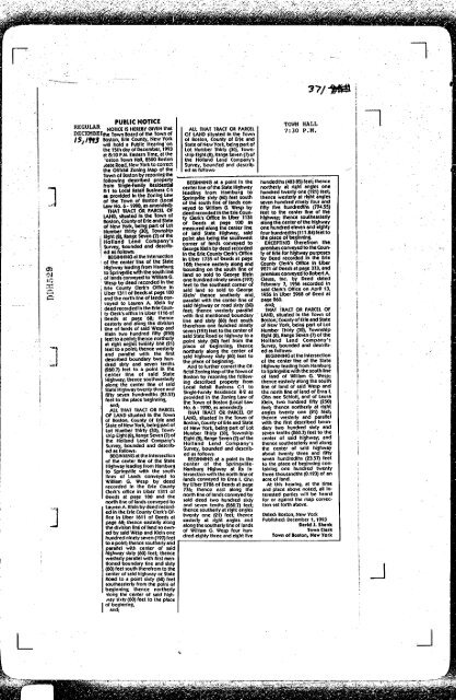
ps^rni »D ''"^"*^ NOTICE<br />
^^^!!..^^ NOTICE IS HEREBY GIVEN that<br />
DECEMBEFtfie Town Board ol the Town of<br />
ISi/9f3 Boston, Erie County. New York<br />
' will hold a Public Hearins on<br />
the 15th day of December, 1993<br />
al 8:10 PM. Eastern Time, at the<br />
'oston Town Hali, 8500 Boston<br />
jtate <strong>Road</strong>, Hew York to correct<br />
the Official Zonins Map of the<br />
Town of Boston by rezonlns the<br />
followlns described property<br />
from Sinsie-Famliy Residential<br />
R-1 to Local Retail Business C-1<br />
es provided In the Zonins law<br />
of the Town of Boston (local<br />
Law No. 6 -1990, as amended):<br />
THAT TRACT OR PARCEL OF<br />
LAND, situated In the Towh of<br />
Boston, County of Erie and State<br />
of New York, beins part of lot<br />
Nutiiber Thirty (30), Township<br />
Elsht (8), Range Seven (7) of the<br />
Holland Land Company's<br />
Survey, bounded and described<br />
as follows:<br />
BEGiNNiNG at the intersection<br />
of the center line of the State<br />
Highway leading from Hamburg<br />
to Sprinsviiie with the south line<br />
of lands conveyed to Wiiiiam G.<br />
Wesp by deed recorded in the<br />
Erie County Clerk's Office In<br />
Liber 1311 of Deeds at page 100<br />
and the north line of lands conveyed<br />
to Lauren A. Klein by<br />
deed recorded in the Erie County<br />
Clerks office in Liber 1116 of<br />
Deeds at page '68; thence<br />
easteriy and along the division<br />
line of lands of said Wesp ahd<br />
Klein hvo hundred fifty (250)<br />
feet to a point; thence northerly<br />
at right angles twenty one (21)<br />
feel to a point; thence westerly<br />
and parallel with the first<br />
described traundary two hundred<br />
sixty and seven tenths<br />
026O.7) feet lo a point In the<br />
center line of said Stale<br />
Highway; thence southwesterly<br />
along the center line of said<br />
State Highway twenty three and<br />
fifty seven hundredths (23.57)<br />
feet to the piace beginning,<br />
and;<br />
ALL THAT TRAO OR PARCEL<br />
OF LAND situated In the Town<br />
of Boston, County of Erie and<br />
State of New York, being part of<br />
Lot Number Thirty pO), Township<br />
Eight (8), Range Seven (7) of<br />
the Holland Land Company's<br />
Survey, ttounded and descrlt><br />
ed as follows:<br />
BEGINNING al the Intersection<br />
of the center line of the State<br />
Highway leading from Hamburg<br />
to Springvilie with the south<br />
lines of Lands conveyed to<br />
William G. Wesp by deed<br />
recorded in the Erie Couniy<br />
Oerks office In Uber 1311 of<br />
Deeds al page 100 and the<br />
north line of lands conveyed to<br />
Lauren A. Klein by deed recorded<br />
In the Erie County Clerk's Office<br />
In Liber 1611 of Deeds al<br />
page 68; thence easterly along<br />
the division line of land so owned<br />
by said Wesp and Klein one<br />
hundred ninety seven (197) feet<br />
to a point; thence southerly and<br />
parallel with center of said<br />
highway sixty (60) feet; Ihehce<br />
westerly parallel with first mentioned<br />
boundary line and sixty<br />
(60) feet soulh therefrom to the<br />
center of said highway or State<br />
<strong>Road</strong> lo a point sixty (60) feet<br />
southeasterly from the point of<br />
beginning; thence northerly<br />
ilong the center of said hlghfJSY<br />
sixty (60) feet lo the place<br />
of beginning,<br />
and;<br />
ALL THAT TRACT OR PARCEL<br />
OF LAND Situated In the Town<br />
of Boston, County of Erje and<br />
State of New York, being part of<br />
Lot Numt>er Thirty (30), Township<br />
Eight (8), Range Seven (7) o(<br />
the Holland land Company's<br />
Survey, bounded and de$crlt>ed<br />
as follows-<br />
BEGINNING at a point In the<br />
center line ofthe Stale Highway<br />
leading from Hamburg to<br />
Springvilie Sixty (60) feet south<br />
of the south line of lands conveyed<br />
to William G. Wesp by<br />
deed recorded In the Erie County<br />
Oerk's Office In Uber 1131<br />
of Deeds at page 100 as<br />
measured afons the center line<br />
of said State Highway, said<br />
point also being the southwest<br />
corner of lands conveyed to<br />
George Klein by deed recorded<br />
In the Erie County Clerk's Office<br />
In Uber 1735 of Deeds at page<br />
108; thence easterly along and<br />
txjundins on the south line of<br />
land so sold to George Klein<br />
one hundred ninety seven (197)<br />
feet to the southeast corner of<br />
said land so sold to George<br />
Klein' thence southerly and.<br />
parallel with the center line of<br />
said highway or road sixty (60)<br />
feet; thence westeriy parallel<br />
with first mentioned boundary<br />
line and sixty (60) feet south<br />
therefrom one hundred ninety<br />
seven (197) feet to the center of<br />
said Stale <strong>Road</strong> or highway to a<br />
point sixty (60) feel from the<br />
place of l>eginnlng; thence<br />
northerly along the center of<br />
said highway sixty (60) feet to<br />
the place of beginning.<br />
And to further correct the Official<br />
Zoning Map of the Town of<br />
Boston by rezoning the following<br />
descriljed property from<br />
local Retail Business C-1 lo<br />
Single-Family Residence R-2 as<br />
provided tn the Zoning Law of<br />
the Town of Boston (Local Law<br />
No. 6 -1990, as amended);<br />
THAT TRACT OR PARCEL OF<br />
LAND, situated in the Town of<br />
Boston, County of Erie and State<br />
of New York, t)elng part of Lot<br />
Number Thirty (30), Township<br />
Eight (8), Range Seven (7) of the<br />
Holland Land Company's<br />
Survey, bounded and descrit>ed<br />
as follows:<br />
BEGINNING at a point In the<br />
center of the Sprlngville-<br />
Hamburg Highway at its intersection<br />
with the north line of<br />
lands conveyed to Erna I. Ohn<br />
by Libier 2726 of Deeds at page<br />
776; thence east along the<br />
north line of lands conveyed by<br />
said deed two hundred sixty<br />
and seven tenths (260.7) feet;<br />
thence southerly at right angles<br />
twenty one (21) feet; thence<br />
easterly at right angles and<br />
along the southerly line of lands<br />
of William G. Wesp four hundred<br />
eighty three and eight five<br />
?7/<br />
TOWN HALL<br />
7:30 P.M,<br />
hundedths (483.85) feel; thence<br />
northerly at right angles one<br />
hundred twenty one (1S1) feet;<br />
thence westerly at right angles<br />
seven hundred ninety four and<br />
fifty five hundredths (794.55)<br />
feet lo the center line of the<br />
highway; thence southeasterly<br />
along the center of the highway<br />
one hundred eleven and eightyfour<br />
hundredths (111.84) feet lo<br />
the place of t>eglnning.<br />
EXCEPTING therefrom the<br />
premises conveyed to the County<br />
of Erie for highway purposes<br />
by Deed recorded In the Erie<br />
County Clerk's Office In Lll)er<br />
2271 of Deeds at page 373, and<br />
premises conveyed lo Rot>ert A.<br />
Clauss, Inc. by Deed dated<br />
February 7, 1956 recorded In<br />
said Oerk's Office on April 13,<br />
1956 in Uber 5968 of Deed at<br />
page 260.<br />
and; ,<br />
THAT TRAa OR PARCEL OF<br />
LAND, Situated In the Town of<br />
Boston, County of Erie and Stale<br />
of New York, being part of lot<br />
Number Thirty (30), Township<br />
Eight (8), Range Seven (7) of the<br />
Holland Land Company's<br />
Survey, (lounded and descri(>ed<br />
as follows:<br />
BEGINNING at the Intersection<br />
of the center line of the State<br />
Highway leading from Hamburg<br />
to Springvilie with the soulh line<br />
of land of William G. Wesp;<br />
thence easterly along the sOulh<br />
Dne of land of said Wesp and<br />
the north line of land of Erna 1.<br />
Ohn nee Schiotl, and of Laura<br />
Klein, two hundred fifty (250)<br />
feet; thence northerly at right<br />
angles twenty one (21) feet;<br />
thence westerly and parallel<br />
with the first descritied txjundary<br />
two hundred sixty and<br />
seven tenths (260.7) feet to the<br />
center of said highway; and<br />
thence southeasterly and along<br />
the center of said highway<br />
about twenty three and fifty<br />
seven hundredths (23.57) feet<br />
lo the place of beginning containing<br />
one hundred twenty<br />
three thousandths (0.123) of an<br />
acre of land.<br />
At this hearing, at the time<br />
and place above noted, all interested<br />
parties will be heard<br />
for or against the map correction<br />
set forth atx>ve.<br />
Dated: Boston, New York<br />
Published: December 1,1993<br />
David J. Shenk<br />
Town Clerk<br />
Town of Boston, New York