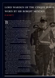
An important vellum manuscript chart of the Dutch East India Company
An important vellum manuscript chart of the Dutch East India Company
An important vellum manuscript chart of the Dutch East India Company

You also want an ePaper? Increase the reach of your titles
YUMPU automatically turns print PDFs into web optimized ePapers that Google loves.
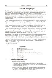
The <strong>chart</strong> here belongs to <strong>the</strong> first group and is specified on <strong>the</strong> list as ‘Indische zee<br />
gelijkgradige van de Caap tot de Straat Sunda’ [Plane <strong>chart</strong> <strong>of</strong> <strong>the</strong> <strong>India</strong>n Ocean, from <strong>the</strong><br />
Cape to Sunda Straits], for a price <strong>of</strong> six guilders and ten stuivers (halfpennies). The <strong>chart</strong><br />
plays a key role for <strong>the</strong> crossing and navigation <strong>of</strong> <strong>the</strong> <strong>India</strong>n Ocean. After a compulsory<br />
period <strong>of</strong> rest at <strong>the</strong> Cape <strong>of</strong> Good Hope, <strong>the</strong> VOC ships were required to follow a prescribed<br />
route (sailing instructions or sailing orders) for <strong>the</strong> journey from <strong>the</strong> Cape to <strong>the</strong> Sunda Strait.<br />
The course first had to be set due south to <strong>the</strong> regions with continuous blowing westerns<br />
winds. With <strong>the</strong>se advantageous sailing winds one had to sail 850 miles to <strong>the</strong> east and <strong>the</strong>n<br />
steer <strong>the</strong> bow north towards Sunda Strait.<br />
Because determining longitude on <strong>the</strong> open sea was <strong>of</strong> great difficulty in those days, <strong>the</strong><br />
crossing <strong>of</strong> <strong>the</strong> <strong>India</strong>n Ocean was a hazardous journey. By changing eastern to nor<strong>the</strong>rn course<br />
too late, some VOC ships unexpectedly ran aground on <strong>the</strong> reefs and shoals <strong>of</strong> <strong>the</strong> west coast<br />
<strong>of</strong> Australia and sank, especially in darkness. A famous fatality is <strong>the</strong> 1727 shipwreck <strong>of</strong> <strong>the</strong><br />
Zeewijck, a 70 tonnes vessel equipped by <strong>the</strong> Chamber <strong>of</strong> Zeeland.<br />
Part <strong>of</strong> <strong>the</strong> west coast <strong>of</strong> Australia is visible on this <strong>chart</strong> (ill. 5). Despite <strong>the</strong> fact that <strong>the</strong> outer<br />
corner has been cut <strong>of</strong>f (because <strong>of</strong> <strong>the</strong> later use as book binding), <strong>the</strong> Australian coast is<br />
visible under <strong>the</strong> name [Land van] den Eendragt, a name originating from <strong>the</strong> oldest <strong>Dutch</strong><br />
contact with this coast by <strong>the</strong> ship Eendracht in 1616. On our <strong>chart</strong> this is also testified by <strong>the</strong><br />
name Dirck Hartogs Rhee.<br />
A remarkable feature <strong>of</strong> this <strong>chart</strong> is <strong>the</strong> reference to <strong>the</strong> 1727 calamity <strong>of</strong> <strong>the</strong> Zeewijck:<br />
Zee[wijck] geble[ven] (Zee[wijck] lost here). On June 9, 1727, this 145 foot ship ran aground<br />
on one <strong>of</strong> <strong>the</strong> coral reefs (Half Moon Reef) <strong>of</strong> <strong>the</strong> Houtman Abrolhos. Part <strong>of</strong> <strong>the</strong> castaways<br />
could survive on nearby Gun Island and after many miseries <strong>the</strong>y succeeded to build a small<br />
sloop from <strong>the</strong> wreck <strong>of</strong> <strong>the</strong> Zeewijck. After ten months, approximately 90 men (<strong>of</strong> <strong>the</strong> crew<br />
<strong>of</strong> 208 that had sailed from Zeeland) managed to leave Gun Island. Incredibly, <strong>the</strong>y managed<br />
to reach Sunda Strait and arrived in Batavia in April 30, 1728.<br />
The reference to <strong>the</strong> wreckage <strong>of</strong> <strong>the</strong> Zeewijck has not been recorded on any o<strong>the</strong>r known<br />
VOC <strong>vellum</strong> <strong>chart</strong> <strong>of</strong> <strong>the</strong> <strong>India</strong>n Ocean, <strong>the</strong> fact that it is recorded here is a fur<strong>the</strong>r<br />
confirmation that this <strong>chart</strong> was produced in Middelburg. In <strong>the</strong> waters between <strong>the</strong> Australian<br />
coast and Java a few islands can be seen. The name Trials Rudsen reminds <strong>the</strong> loss <strong>of</strong> <strong>the</strong><br />
English ship Trial in 1622, and <strong>the</strong> name Monij (today’s Christmas Island) goes back to <strong>the</strong><br />
visit <strong>of</strong> <strong>the</strong> fleet <strong>of</strong> Willem de Vlamingh in 1697.<br />
Our <strong>chart</strong> shows hundreds <strong>of</strong> toponyms along <strong>the</strong> coasts. Although <strong>the</strong> majority is in Portuguese,<br />
we also see <strong>Dutch</strong> names along <strong>the</strong> west coast <strong>of</strong> Sumatra (Cocos Eijlanden, ’t Verkens Eijland,<br />
Goefortuijn, Nassou); on Sumatra (gebroken Hoek, vlacke Hoek); in Sunda Strait (t Prince<br />
Eijland). Remarkable in Malacca is <strong>the</strong> reference to Straet Sincapura. In Bengal <strong>the</strong><br />
Timmerswerf (carpenter’s wharf) is mentioned. On <strong>the</strong> Orissa coast is a reference to <strong>the</strong> 1643<br />
disaster <strong>of</strong> ano<strong>the</strong>r VOC ship: Neptunus verongeluckt (Neptunus lost).<br />
The plane <strong>chart</strong> f <strong>the</strong> <strong>India</strong>n Ocean did not only serve for <strong>the</strong> crossing to Sunda Strait, but also for<br />
<strong>the</strong> journey to Ceylon. After approximately 700 miles east <strong>of</strong> <strong>the</strong> Cape, <strong>the</strong> course is changed<br />
north, as is testified on our <strong>chart</strong> by faint traces <strong>of</strong> a plotted track in pencil (<strong>of</strong> which<br />
unfortunately only <strong>the</strong> number 14 is decipherable, tracks were drawn in pencil and erased later).